Showing 414 items matching "parker road"
-
 Mont De Lancey
Sewing kit
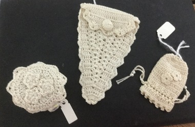
Worked by Edna Parker (nee Rouget)Set of 3 antique white, crocheted sewing equipment items: Scissors bag, tape measure holder and a thimble bag, each with a different crocheting pattern. The scissors bag has a crocheted button closer, the tape measure holder has 3 crocheted flowers and 3 small crystal beads on the lid and a toggle-shaped crystal closer and the thimble bag has a cotton drawstring closer with 2 pearl beads on either side and 2 crocheted flowers on front side of bag.sewing equipment, personal effects. -
 Camberwell Historical Society
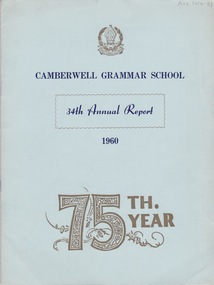
Booklet (Item), Camberwell Grammar School, Camberwell Grammar School 34th Annual Report 1960, 1960
camberwell, school -
 Camberwell Historical Society
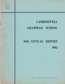
Booklet (Item), Camberwell Grammar School, Camberwell Grammar School 36th Annual Report 1962, 1962
camberwell, school -
 Camberwell Historical Society
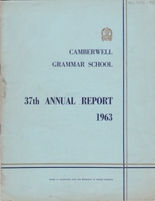
Booklet (Item), Camberwell Grammar School, Camberwell Grammar School 37th Annual Report 1963, 1963
camberwell, school -
 Mont De Lancey
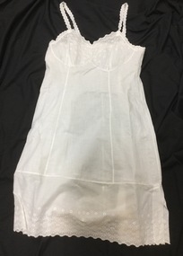
Petticoat
Worn by Mrs. Edna ParkerWhite lawn full petticoat. Lace on bodice and hem.petticoats, underwear -
 Mont De Lancey
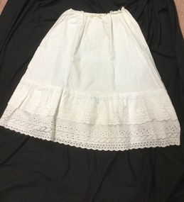
Petticoat
Worn by Mrs. Edna ParkerWhite lawn half slip petticoat, with deep two tiered broderie anglaise lace hem. Has blue ribbon trim.petticoats, underwear -
 Mont De Lancey
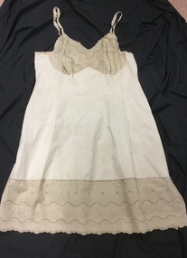
Petticoat
Worn by Mrs. Edna ParkerCoffee coloured full petticoat with lace trim on bodice and hem.petticoats, underwear -
 Wodonga & District Historical Society Inc
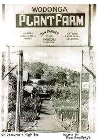
Photograph - Wodonga Plant Farm
Stan and Mary Parker commenced the Plant Farm in Smythe Street Wodonga in February 1949. The nursery consisted of two blocks, on one of which their house was built. They started off with approximately £70 and a 1939 Singer mini-Ute. In the early days most customers came from the farming community. In late 1951 the Parkers purchased to a new site on the corner of High and Osburne Streets. Business went well and in 1957 they purchased the adjoining block. They later demolished the old house on the corner of High Street and Osburne Street, building a new home lower on the same block. As the nursery prospered Stan and Mary built a shop and showrooms with glassed-in portion for the indoor plants and a large shaded area for the display of shrubs. In 1978 they sold the nursery to Mr. & Mrs. John Gale. In 1981 the Wodonga Plant farm was purchased Geoff and Kay Pollard and they moved to its current location at the corner of Beechworth Road and Huon Creek Road. Initially they brought it as an investment but it soon got into their blood and chose to not only continue but expand the nursery and its offerings. This included a large showroom, a water shop which specialises in pool equipment, chemicals and water testing, a children's playground and an outdoor blind centre. Further expansions led to the addition of a Tuscan-style cafe on the site which has become a meeting place. The business was nominated the Yates Victorian Best Garden Centre in Australia for many years and won the award in 1997. In 2024, the Wodonga Plant Farm is still a vibrant and popular business being operated by the Pollard Family.These items are significant because they document the story of respected Wodonga Business which has served the community for over 60 years.A selection of photographs and article documenting the story of the Wodonga Plant Farmearly wodonga businesses, wodonga plant farm, pollard family, geoff and kay pollard -
 Wodonga & District Historical Society Inc
Drawing - The Green Hills School
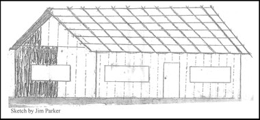
Green Hills School was the first school in the Wodonga area. Before the school could open and a teacher commence duties, the Government had to be assured that a minimum of 20 children would be attending. The school was built of round timber, slab walls, bark roof, dirt floor and shuttered windows. The school opened in 1850 and closed in 1870. This sketch, completed by Jim Parker, a Life Member of Wodonga & District Historical Society, was included on a commemorative plaque as part of the Wodonga Heritage Drive established by the Society to recognise the story of key historic locations in the Wodonga area.This drawing is significant because it depicts the first school opened in Wodonga.A sketch of Green Hills School completed by Jim Parker, a life member of Wodonga & District Historical Society. This sketch was completed as part of a project to place commemorative plaques at key locations around Wodonga green hills school, wodonga schools, education wodonga -
 City of Kingston
Photograph - Black and white, c. 1960
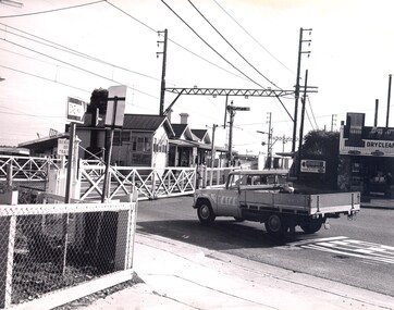
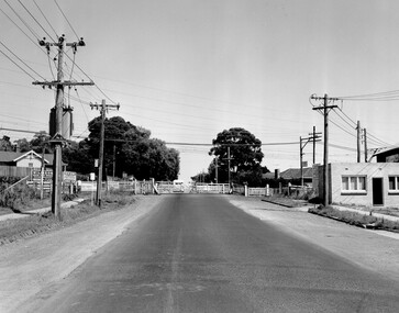
... City of Kingston Parkdale Library 96 Parkers Road, Parkdale ...Highett railway station with crossing gates closed and traffic waiting.Black and white photograph of Highett railway gates. Gates are closed and a ute is waiting at the crossing.Stamped on reverse: COPYRIGHT / Public Transport Corporation / For re-ordering photographs / Please quote negative No H3985 / Enquiries C/- PIC Photographic Unit / Telephone switchboard 519 1111highett, city of kingston, level crossing, railway station -
 City of Kingston
Photograph - Black and white, c. 1960
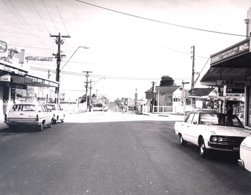
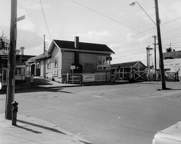
... City of Kingston Parkdale Library 96 Parkers Road, Parkdale ...One image from a collection of images produced by Public Transportation Corporation showing train stations and other public transport options around the (now) City of KingstonBlack and white photograph of Highett railway station and nearby shops, Highett Road, Highett.Stamped in blue ink on reverse: COPYRIGHT / Public Transport Corporation / For re-ordering photographs / Please quote negative No H3986 / Enquiries C/- PTC Photographic Unit / Telephone switchboard 619 111highett, railway station, strip shopping -
 City of Kingston
Photograph - Black and white, c. 1960
... City of Kingston Parkdale Library 96 Parkers Road, Parkdale ...This image is part of a larger collection of images from the Public Transport Corporation displaying train stations and streetscapes in what is now the City of Kingston.Black and white photograph of crossed level crossing gates at McKinnon railway station. The image also affords a street view which includes the shopping strip where advertising signs abound.Stamped in blue ink on reverse: COPYRIGHT / Public Transport Corporation / For re-ordering photographs / Please quote negative No PR4764 / Enquiries C/- PTC Photographic Unit / Telephone switchboard 619 111mckinnon, railway station, streetscape, shopping strip, suburbs -
 City of Kingston
Photograph - Black and white, Public Transport Corporation, c. 1960
... City of Kingston Parkdale Library 96 Parkers Road, Parkdale ...This image is part of a larger collection of images from the Public Transport Corporation displaying train stations and streetscapes in what is now the City of Kingston.Black and white photograph of level crossing at McKinnon railway station with crossing gates open. The image also provides a streetscape which includes businesses and signage.Stamped in blue ink on reverse: COPYRIGHT / Public Transport Corporation / For re-ordering photographs / Please quote negative No PR4762 / Enquiries C/- PTC Photographic Unit / Telephone switchboard 619 111mckinnon, suburbs, railway station, streetscape, shopping strip -
 City of Kingston
Photograph - Black and white, c. 1958
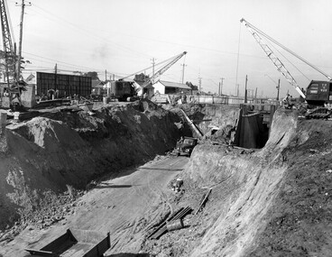
... City of Kingston Parkdale Library 96 Parkers Road, Parkdale ...Moorabbin station sits on the Frankston line which first opened in 1882 when the line was extended from Mordialloc. Moorabbin station opened in 1881 and was originally called South Brighton station. It was renamed Moorabbin station in 1907. In 1958 the station was relocated below street level which coincided with other construction works on Nepean Highway and South Road. This image is part of a larger collection of images from the Public Transport Corporation displaying train stations and streetscapes in what is now the City of Kingston.Black and white photograph showing excavations for Moorabbin station to be moved below street level. Stamped in blue ink on reverse: COPYRIGHT / Public Transport Corporation / For re-ordering photographs / Please quote negative No M6004 / Enquiries C/- PTC Photographic Unit / Telephone switchboard 619 111moorabbin, railway station, construction works, suburbs, nepean highway -
 City of Kingston
Photograph - Black and white, Public Transport Corporation, c. 1960
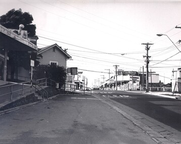
... City of Kingston Parkdale Library 96 Parkers Road, Parkdale ...This image is part of a larger collection of images from the Public Transport Corporation displaying train stations and streetscapes in what is now the City of Kingston.Black and white photograph depicting the run in to the level crossing at Cheltenham railway station, along Charman Road. The image also depicts a streetscape which includes a shopping strip. The level gates are closed and two cars can be seen stopping and waiting, while several more cars are parked on each side of the road.Stamped in blue ink on reverse: COPYRIGHT / Public Transport Corporation / For re-ordering photographs / Please quote negative No H3378 / Enquiries C/- PTC Photographic Unit / Telephone switchboard 619 111cheltenham, railway station, streetscape, surburb -
 City of Kingston
Photograph - Black and white, c. 1960
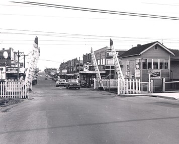
... City of Kingston Parkdale Library 96 Parkers Road, Parkdale ...This image is part of a larger collection of images from the Public Transport Corporation displaying train stations and streetscapes in what is now the City of Kingston.Black and white photograph depicting the level crossing at Highett, with the shopping street visible in the foreground. There are several cars parked on both sides of the road and a bus has just crossed the crossing (on the left hand side).Stamped in blue ink on reverse: COPYRIGHT / Public Transport Corporation / For re-ordering photographs / Please quote negative No H3983 / Enquiries C/- PTC Photographic Unit / Telephone switchboard 619 111highett, railway station, suburbs, streetscape -
 City of Kingston
Photograph - Black and white, Public Transport Corporation, c. 1960
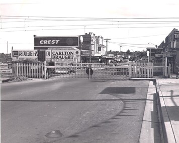
... City of Kingston Parkdale Library 96 Parkers Road, Parkdale ...Black and white photograph depicting closed crossing gates at the level crossing at Park Road, Cheltenham. This image is part of a larger collection of images from the Public Transport Corporation displaying train stations and streetscapes in what is now the City of Kingston.Black and white photograph of Cheltenham level crossing at Park Road, Cheltenham. The gates are closed. Stamped in blue ink on reverse: COPYRIGHT / Public Transport Corporation / For re-ordering photographs / Please quote negative No H3052 / Enquiries C/- PTC Photographic Unit / Telephone switchboard 619 111 White paper stuck to reverse of image, with black typed text: Cheltenham Park Road, Cheltenham / 1965 / $50 reproduction fee appliescheltenham, railway crossing, suburbs, public transport -
 City of Kingston
Photograph - Black and white, c. 1969
... City of Kingston Parkdale Library 96 Parkers Road, Parkdale ...Black and white photograph of level crossing gates and railway station at Bentleigh at the intersection of Burgess Street and Centre Road. This image is part of a larger collection of images from the Public Transport Corporation displaying train stations and streetscapes in what is now the City of Kingston.Black and white photograph of level crossing gates and railway station at Bentleigh at the intersection of Burgess Street and Centre Road.Stamped in blue ink on reverse: COPYRIGHT / Public Transport Corporation / For re-ordering photographs / Please quote negative No H3405 / Enquiries C/- PTC Photographic Unit / Telephone switchboard 619 111 White paper adhered to reverse of photograph with black typed text: Railway gates, Centre Road Bentleigh / 1969 / $50 reproduction fee appliesbentleigh, railway station, railway crossing, suburbs, public transport -
 City of Kingston
Photograph - Black and white, Public Transport Corporation, c. 1959
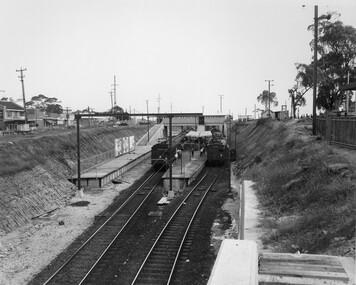
... City of Kingston Parkdale Library 96 Parkers Road, Parkdale ...Black and white photograph of Moorabbin railway station, at the completion of works to relocate it to below street level. There are two "red rattler" trains pulled in to the station, utilising each of its two tracks and two of its three platforms. A third platform is visible to the left of the image, but no tracks have been laid to allow for an additional train. This image is part of a larger collection of images from the Public Transport Corporation displaying train stations and streetscapes in what is now the City of Kingston.Black and white photograph of Moorabbin railway station, at the completion of works to relocate it to below street level. There are two "red rattler" trains pulled in to the station, utilising each of its two tracks and two of its three platforms. A third platform is visible to the left of the image, but no tracks have been laid to allow for an additional train. Stamped in blue ink on reverse: COPYRIGHT / Public Transport Corporation / For re-ordering photographs / Please quote negative No M6859 / Enquiries C/- PTC Photographic Unit / Telephone switchboard 619 111moorabbin, railway station, red rattler, public transport -
 City of Kingston
Photograph - Black and white, c. 1957
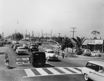
... City of Kingston Parkdale Library 96 Parkers Road, Parkdale ...Copy black and white photograph of railway level crossing on Nepean Highway Moorabbin before excavations for the below ground rail crossing. The level crossing gates are closed and five cars are waiting, while other cars can be seen coming in the opposite direction. A woman with a child in a pram is walking along the road, and a number of men, probably construction workers, are standing behind a barricade on the right hand side of the road. Gilbey's Gin distillery is visible in the background. TCopy black and white photograph of railway level crossing on Nepean Highway Moorabbin before excavations for the below ground rail crossing. The level crossing gates are closed and five cars are waiting, while other cars can be seen coming in the opposite direction. A woman with a child in a pram is walking along the road, and a number of men, probably construction workers, are standing behind a barricade on the right hand side of the road. Gilbey's Gin distillery is visible in the background. Handwritten in blue ink on reverse: 57-465C Handwritten in red ink on reverse: 71% A red circle has been drawn around all handwritten text.moorabbin, railway station, railway crossing, suburbs, cars, local production -
 City of Kingston
Photograph - Black and white, c. 1956
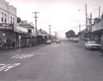
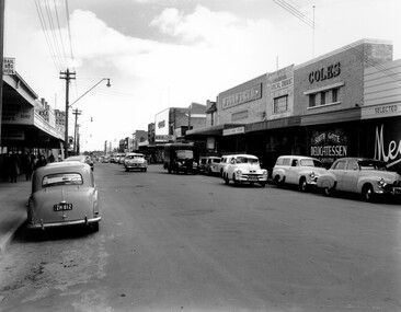
... City of Kingston Parkdale Library 96 Parkers Road, Parkdale ...Black and white photograph depicting Centre Road Bentleigh, looking west. On the right hand side of the road there are two Coles stores. The one in the background is the newly opened store while the one in the foreground has been repurposed and is now a delicatessen. There are numerous cars parked on both sides of the road, including one that appears to be "double parked" on the right hand side of the road.Black and white photograph depicting Centre Road Bentleigh, looking west. On the right hand side of the road there are two Coles stores. The one in the background is the newly opened store while the one in the foreground has been repurposed and is now a delicatessen. There are numerous cars parked on both sides of the road, including one that appears to be "double parked" on the right hand side of the road.Handwritten in blue ink on a white sticker adhered to the reverse of the photograph: COLES BENTLEIGH c. 1956 / Centre Road looking west / The Old Coles store is in the foreground / and the new Coles is in the background.bentleigh, suburbs, shopping strip, cars -
 City of Kingston
Photograph - Black and white, c. 1950
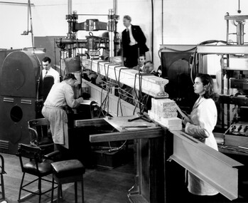
... City of Kingston Parkdale Library 96 Parkers Road, Parkdale ...CSIRO, the Commonwealth Scientific and Industrial Research Organisation, moved into a former RAAF factory in Highett in the post-war years. CSIRO closed down the Highett facility and sold it in 2011.Black and white photograph of workers at CSIRO (Commonwealth Scientific and Industrial Research Organisation) complex in Highett. In this image, building materials are being tested. In the foreground is physicist Valerie Goullet, standing top centre is Dr Keith Martin both CSIRO Division of Building Research.Small white sticker adhered to reverse of image with printed black text: 206 Handwritten in red ink on reverse of image: 53%science, highett, workers, industry -
 City of Kingston
Photograph - Black and white, c. 1950
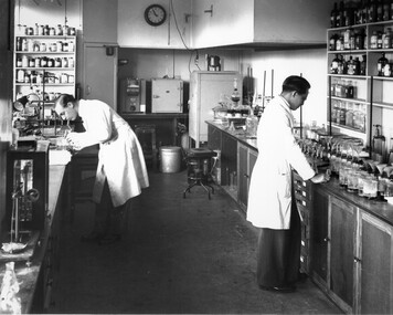
... City of Kingston Parkdale Library 96 Parkers Road, Parkdale ...CSIRO, the Commonwealth Scientific and Industrial Research Organisation, moved into a former RAAF factory in Highett in the post-war years. CSIRO closed down the Highett facility and sold it in 2011.Black and white photograph of workers at the CSIRO (Commonwealth Science and Industrial Research Organisation) facility in Highett.Small white circular sticker with black printed text: 205 Handwritten in red ink: 55%science, highett, workers, industry -
 City of Kingston
Photograph - Colour, Paul Tresize, 1998
... City of Kingston Parkdale Library 96 Parkers Road, Parkdale ...The name Mordialloc was derived from the name Moody Yallock, which comes from the Bunurong language. The Bunurong Peoples are the Traditional Owners of this area. The name means “high water” or “high creek”. In 1839, colonial authorities declared the mouth of the creek, and an additional 830 odd acres as an Aboriginal Reserve, although this proclamation was never gazetted. The reserved land included part of the Carrum Carrum Swamp which was abundant with wild life and natural resources. Regular encroachments, including land sales which began in 1863, were made on the land until 1878 when the Reserve was declared closed, and the land was opened up to land sales. Market gardening and suburban house lots quickly began to develop, and Mordialloc became a renowned picnic and holiday site. Mordialloc Creek is a popular bay side destination for local and visitors, and is a site for boating, kayaking, fishing and swimming, along with many other activities.Colour photograph of Mordialloc Creek, looking out to the bay. Many small fishing and leisure craft are moored on either side of the banks of the creek. To the right hand side can be seen parklands, while the left hand side has a small inlet in which more small crafts are moored.mordialloc, bunurong, traditional owners, suburbs, boats, fishing, waterways -
 City of Kingston
Photograph - Colour, 1998
... City of Kingston Parkdale Library 96 Parkers Road, Parkdale ...The name Mordialloc was derived from the name Moody Yallock, which comes from the Bunurong language. The Bunurong Peoples are the Traditional Owners of this area. The name means “high water” or “high creek”. In 1839, colonial authorities declared the mouth of the creek, and an additional 830 odd acres as an Aboriginal Reserve, although this proclamation was never gazetted. The reserved land included part of the Carrum Carrum Swamp which was abundant with wild life and natural resources. Regular encroachments, including land sales which began in 1863, were made on the land until 1878 when the Reserve was declared closed, and the land was opened up to land sales. Market gardening and suburban house lots quickly began to develop, and Mordialloc became a renowned picnic and holiday site. Mordialloc Creek is a popular bay side destination for local and visitors, and is a site for boating, kayaking, fishing and swimming, along with many other activities.Colour photograph of Mordialloc Creek, looking inland.Small fishing and leisure boats are moored on either side of creek, with a view of the Mordialloc Bridge Hotel in the background.mordialloc, bunurong, traditional owners, suburbs, boats, fishing, waterways, hotel -
 City of Kingston
Photograph - Colour, Paul Tresize, 1998
... City of Kingston Parkdale Library 96 Parkers Road, Parkdale ...The name Mordialloc was derived from the name Moody Yallock, which comes from the Bunurong language. The Bunurong Peoples are the Traditional Owners of this area. The name means “high water” or “high creek”. In 1839, colonial authorities declared the mouth of the creek, and an additional 830 odd acres as an Aboriginal Reserve, although this proclamation was never gazetted. The reserved land included part of the Carrum Carrum Swamp which was abundant with wild life and natural resources. Regular encroachments, including land sales which began in 1863, were made on the land until 1878 when the Reserve was declared closed, and the land was opened up to land sales. Market gardening and suburban house lots quickly began to develop, and Mordialloc became a renowned picnic and holiday site. Mordialloc Creek is a popular bay side destination for local and visitors, and is a site for boating, kayaking, fishing and swimming, along with many other activities.Colour photograph of Mordialloc Creek, looking inland. Boats are moored on either side of the creek and the Bridge Hotel is visible in the background.mordialloc, bunurong, traditional owners, suburbs, boats, fishing, waterways, hotel -
 City of Kingston
Photograph - Colour, Paul Tresize, 1998
... City of Kingston Parkdale Library 96 Parkers Road, Parkdale ...The name Mordialloc was derived from the name Moody Yallock, which comes from the Bunurong language. The Bunurong Peoples are the Traditional Owners of this area. The name means “high water” or “high creek”. In 1839, colonial authorities declared the mouth of the creek, and an additional 830 odd acres as an Aboriginal Reserve, although this proclamation was never gazetted. The reserved land included part of the Carrum Carrum Swamp which was abundant with wild life and natural resources. Regular encroachments, including land sales which began in 1863, were made on the land until 1878 when the Reserve was declared closed, and the land was opened up to land sales. Market gardening and suburban house lots quickly began to develop, and Mordialloc became a renowned picnic and holiday site. Mordialloc Creek is a popular bay side destination for local and visitors, and is a site for boating, kayaking, fishing and swimming, along with many other activities.Colour photograph of Mordialloc Creek with boats moored on both sides of the street and Pompei's boat yard visible on the right hand side of the creek., Main Street and St Brigid's Catholic Church are visible in backgroundmordialloc, bunurong, traditional owners, suburbs, boats, fishing, waterways, hotel, church -
City of Kingston
Photograph - Colour, Paul Tresize, 1998
... City of Kingston Parkdale Library 96 Parkers Road, Parkdale ...The name Mordialloc was derived from the name Moody Yallock, which comes from the Bunurong language. The Bunurong Peoples are the Traditional Owners of this area. The name means “high water” or “high creek”. In 1839, colonial authorities declared the mouth of the creek, and an additional 830 odd acres as an Aboriginal Reserve, although this proclamation was never gazetted. The reserved land included part of the Carrum Carrum Swamp which was abundant with wild life and natural resources. Regular encroachments, including land sales which began in 1863, were made on the land until 1878 when the Reserve was declared closed, and the land was opened up to land sales. Market gardening and suburban house lots quickly began to develop, and Mordialloc became a renowned picnic and holiday site. Mordialloc Creek is a popular bay side destination for local and visitors, and is a site for boating, kayaking, fishing and swimming, along with many other activities.Colour photograph of Mordialloc Creek with boats moored on both sides of the street and Pompei's boat yard visible on the right hand side of the creek., Main Street and St Brigid's Catholic Church are visible in background.mordialloc, bunurong, traditional owners, boats, fishing -
 City of Kingston
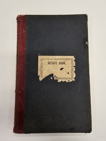
Book - Minute book, Minute book of the Cheltenham Rifle Club, 1900
... City of Kingston Parkdale Library 96 Parkers Road, Parkdale ...At a well attended meeting at the Mechanics Hall in Cheltenham in March 1900, attendees decided to form a rifle club. The newly appointed secretary of the newly formed Cheltenham Rifle Club, Mr E.C. Rippon, enrolled 55 new members on the day, and the club resolved to consult with the Defence Department regarding the suitability of Cheltenham Park for that purpose, and Moorabbin Council to grant the use of the park. By 1912 the club was already on the verge of disintegrating. The Cheltenham Park range had been disbanded two years earlier. A new, shorter range and club rooms were completed in October 1912. The club continued to have difficulties over location and funds, despite being granted an exemption from paying rates for the duration of the First World War. In 1919, a proposal to disband was put forward at a club meeting. Members rejected the proposal deciding instead to wait on the rumoured reopening of the Langwarrin range. By 1921 it became evident the Langwarrin range would not reopen. A resolution to wind up the organisation was put to the meeting and accepted.Green, cloth bound book with red leather spine. A white label is adhered to the front of the book with MINUTE BOOK printed in black text. The book is hardcovered and, inside, are approximately 186 pages which have been filled with handwritten text as meeting minutes and lists, including a list of commitee officers. The inside fly pages are decorated with blue and red marbling.Handwritten text on the white paper adhered to the front of the book is no longer legible.cheltenham, sport, club, rifles -
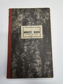 City of Kingston
Book - Minute book, Minute book of the Cheltenham Junior Tennis Club, 1923
... City of Kingston Parkdale Library 96 Parkers Road, Parkdale ...This minute shows committee members and participants in the Cheltenham Junior Tennis Club, as well as their activities over the years 1923 to 1948. Hardcover book with marbled appearance and white paper label on the front. Handwritten in blue ink on paper label: CHELTENHAM JUNIOR TENNIS / CLUB / 1945cheltenham, sport, tennis, committee