Showing 315 items
matching playground
-
 Eltham District Historical Society Inc
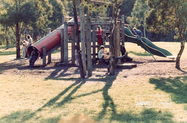
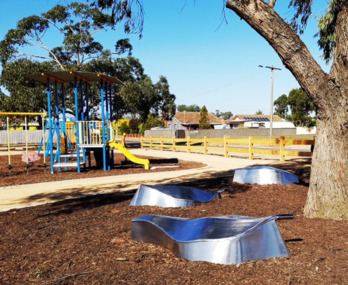
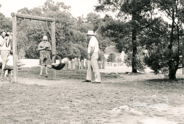
Photograph, Eltham Town Park, Shire of Eltham, 1985, 1985
Shire of Eltham Archives Series 13, Photograph Album, 1985. Originally contained in a 2-ring PVC binder and document sleevesOne colour and four black and white photographsseries 13, shire of eltham archives, shire of eltham, eltham town park, playground -
 Ringwood and District Historical Society
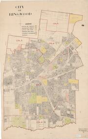
Map, City of Ringwood - Rateable Properties Layout - c.1966. Overlay showing Reserves, Open Space, Playgrounds, and Schools
A0-size (approx) map of named streets, lot-numbered properties and locality features within City of Ringwood boundary. Colour-coded legend identifying Existing Rec Reserves, Proposed Rec Reserves, Existing Open Space, Children's Playgrounds, and Schools.Scale: 8 chains to 1 inch. Map picked up in Engineer's office at old town hall prior to demolition 1971. -
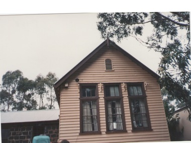
 Galen Catholic College
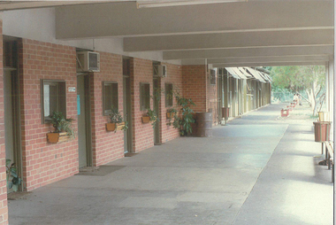
Photograph - Galen Catholic College Junior School buildings and schoolyards c. 1988
These photographs were taken of various interiors and exteriors of the buildings and the playground at the junior school at Galen Catholic College. in about 1988. This was an important time in the school's history, as the Ryley Street campus closed at the end of 1989. .school grounds & buildings, galen catholic college, galen college -
 Ringwood and District Historical Society
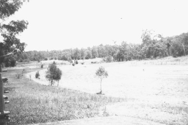
Photograph, Boundary Photo across Dandenong Ck towards Ringwood (H E Parker Reserve). 1979
Written on back of photograph, "Jan. 79 - boundary photo. Looking across Dandenong Creek towards Ringwood (H.E. Parker Reserve) - ?? South East corner of Ringwood. From children's playground end of Derwent (?) St." -
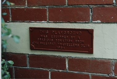 Ballarat Heritage Services
Photograph - Photograph - Colour, Dorothy Wickham, Sign at Alexandra Babies' Home, 2000
The plaque reads: This playground was equipped by a gracious donation from the Ballarat Travellers Club 1954. The plaque was on the wall of the Alexandra Babies' Home in Scott's Parade Ballarat. The home is adjacent to the building known as the Ballarat Female Refuge. Postcard size coloured photographellis, sarah ellis, ballarat female refuge, ballarat, welfare, town and city mission, women, alexandra babies home, baby, orphanage -
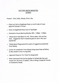 Bendigo Historical Society Inc.
Document - LONG GULLY HISTORY GROUP COLLECTION: HISTORY GROUP MINUTES 12/8/97
History Group Minutes 12/8/97. Present: Carol, Kelly, Wendy, Peter and Ray. Mentioned in the minutes are: Hall on Eaglehawk Road, Diary on Eaglehawk Road, back of Spotlight, Community House Meeting, Gold Mine Vic Hill, Playground, Why chosen to live in Long Gully, Approach Powercor for trees for playground and Peter has spoken to Carmel who has just moved into the area. History Group Minutes. Present: Kelly and Linda. Items on the agenda are: Visited Rae's house, Visited Wayne from the Cheapest Butcher in Bendigo. and Peter has passed on the National Trust phone number earlier in the week.bendigo, history, long gully history group, the long gully history group - history group minutes 12/8/97, spotlight, community house, gold mine vic hill, powercor, carol, kelly, wendy, peter, ray, carmel -
 University of Melbourne, Burnley Campus Archives
Plan, Royal Children's Hospital, 1989-1991
(1) Landscape Concept Royal Children's Hospital by Bates Smart and McCutcheon. (2) Tracing paper Sketch Plan. Scale 1:250 dated 29.3.90 by Jill Kellow. (3) Garden Project, The Foundation Royal Children's Hospital by Denise L. Stephens, DLS Design. Sheet 6 of 7, May 1990. Scale 1:100. (4) Photocopy of Surfaces and Playground Equipment, Royal Children's Hospital, August 1991. No 9046/01. Scale 1:100. (5) Photocopy of Surfaces and Playground Equipment, Royal Children's Hospital, August 1991. No 9046/02. Drawn By R.K. Scale 1:100.royal children's hospital, bates smart, jill kellow -
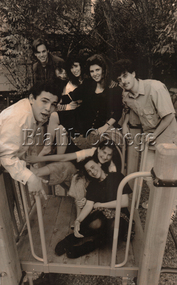 Bialik College
Photograph - Year 12 graduating students, 1990, 1990
Year 12 students on the playground, Hawthorn East campus, 1990. The photograph was published in newspaper article, 'Bialik's class of '90', The Australian Jewish News, 9 November 1990. Please contact [email protected] to request access to this record.vce, graduation, 1990s -
Bialik College
Plan (item) - Extensions to Bialik College, c. 1990s and 2002
Plans for extensions to Bialik College, 429 Auburn Rd, Hawthorn, created by Ron Unger & Associates Architects, c. 1990s. Includes a plan for the new Primary School playground, 2002. Please contact [email protected] to request access to this record.1990s -
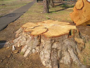 Sunbury Family History and Heritage Society Inc.
Photograph, Rosa McCall, Felled tree, October 2014
A large gum tree, which was growing ing the Village Green was shedding its branches and as it was growing in a public area and in front of a kindergarten the tree was felled as it was dying. St. Andrew's Kindergarten recycled the timber to make playground equipment and furniture in the garden.A print of a coloured digital photograph of the base of a large tree that has been felled. Part of the trunk can be seen in the top RH corner.sunbury village green, st. andrew's kindergarten, gum trees -
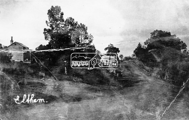 Eltham District Historical Society Inc
Photograph, Eltham, Main Road. Looking south
Source: Miss E. McColl, 8 Anderson St., Heidelberg. 3084 Cross Ref: 0614 Henry Street on left - now (1970) closed off at this point. House on left now demolished and site is playground for R.C. School. Bakery centre.This photo forms part of a collection of photographs gathered by the Shire of Eltham for their centenary project book,"Pioneers and Painters: 100 years of the Shire of Eltham" by Alan Marshall (1971). The collection of over 500 images is held in partnership between Eltham District Historical Society and Yarra Plenty Regional Library (Eltham Library) and is now formally known as the 'The Shire of Eltham Pioneers Photograph Collection.' It is significant in being the first community sourced collection representing the places and people of the Shire's first one hundred years.Digital imagesepp, shire of eltham pioneers photograph collection, eltham, main road -
Greensborough Historical Society
Magazine, Banyule City Council, Banyule Banner July 2024, 2024_07
The Banyule Banner is published by Banyule Council to advertise upcoming events in the City of Banyule and to report on past events. This edition contains reports on local playgrounds, protection for trees on private property, Watsonia Town Square and the start of work on the new Rosanna Library.A record of events within the City of Banyule.24 pages, colour illustrations. banyule banner, banyule council -
 Eltham District Historical Society Inc
Photograph, Liz Pidgeon, Heritage Excursion; Eltham Lower Park Walk and Talk, 1 July 2017, 1 July 2017
Newsletter No., 234, June 2017 Heritage Excursion - Saturday 1st July - Eltham Lower Park - Walk and Talk Eltham Lower Park has played an important part in the history of our area since the early days of European settlement when it was used by local residents as an informal racecourse. Prior to that its location at the junction of the Diamond Creek and the Yarra River made it an important meeting place for the Wurundjeri people. The park combines formal elements and sporting facilities with remnant bushland that is of environmental significance. It is home to sporting and horse riding clubs, popular play spaces and the Diamond Valley Miniature Railway, which attracts large numbers of visitors. The park will be the venue for our July excursion which will comprise a walk of about 3.5 km around the park and adjacent areas. Along the way we will discuss the history and natural history of the area. The path along the creek and the river provides a pleasant and scenic walk. This walk on Saturday 1st July is about 3.5 km in length and will take 2 to 2.5 hours. It will start at 2pm at the Main Road car park at the front of the park. (Melway ref 21 H 10). Born Digitalheritage excursion, activities, eltham district historical society, eltham lower park, playground, picnic area -
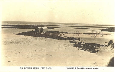 Port Fairy Historical Society Museum and Archives
Photograph - Postcard, The Bathing Beach Port Fairy, 1890
South Beach - bathing boxes and play equipmentBlack and white Photograph of South Beach - bathing boxes and play equipmentWalker & Palmer Series M.4261 The Bathing Beach Port Fairybeach, swings, playground, south beach, pea soup, bathing boxes -
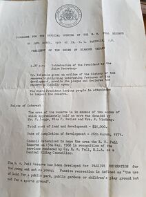 Greensborough Historical Society
Program - Digital Image, Shire of Diamond Valley, Fell Reserve opening 1971, 26/03/1971
Program for the opening of the Fell Reserve on 26/03/1971. Named after Councillor R.W. Fell, MLA, for services rendered as a Central Riding councillor of the Shire of Diamond Valley. The Fell Reserve is located at 170 Grimshaw Street Greensborough. The playground at Fell Reserve is to be renovated in 2020.Digital copy of programr w fell reserve, shire of diamond valley, grimshaw street greensborough -
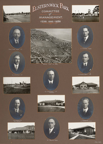 Bayside Gallery - Bayside City Council Art & Heritage Collection
Photograph - gelatin silver photograph, H. Singer, Elsternwick Park Committee of Management 1935-36, 1936
elsternwick park, tennis, football, hockey, playground, sports pavilion, club, ralph tyner, l.l. chapman, cr. g.a. giles, cr. eustace tracey, cr. j.a. kennedy, chairman, cricket, c.e. tuxen, engineer, j.h. taylor, town clerk, treasurer, c.j. pollock, councillor, aerial view, golf, croquet, club house -
Glen Eira Historical Society
Plan - Mount Scopus College, St. Kilda East
A copy of the amended Planning brief for the development of Mount Scopus College dated 24/10/1982. It includes a covering letter listing the amendments. The planning brief describes the school’s facilities, classrooms, playground and the planned development of the school. It includes a site plan and an architect’s illustration of the proposed development.mount scopus college, st. kilda east, city of caulfield, mayfield street, talbot avenue, floyd jeff, building permits, planning act, shaw house, m.m.b.w. planning scheme, classrooms, kindergarten, playgrounds, library, multipurpose hall, car parking, students, teachers, staff, secondary school, primary school, synagogue, architects, syman justin and bialek, site plan, hall, building development, education department, town and country planning board, brick, zoning, traffic, property, landscape planning, planting, fence -
 Lakes Entrance Historical Society
Photograph - Ensay Primary School, 1993
Taken July 1993.Colour photograph of the Ensay Primary School number 2953, East Gippsland. Taken from rear school ground, it shows original timber building with gable roof, brick chimney with chimney pot, portable classroom, playground and out buildings. Large corrugated iron tank on stand at side fence. Ensay Victoriaschools, buildings -
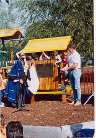 Glen Eira Historical Society
Letter - Halley Park
This file contains three items. A letter to Ms Wendy A. Ross from Hazel Ford, secretary of the Glen Eira Historical Society, dated 31/05/2002. A letter to Felicitie Camplbell from Wendy A. Ross dated 07/05/2002, along with three photographs which were enclosed with the letter, including two of Mayor of Moorabbin, Cr. R. J. Bob Flavell, opening the playground at Halley Park, and one of a plaque. Three photographs including two of Halley Park Opening Ceremony where the Mayor of Moorabbin opened the playground at Halley Park which was the winner of the COMMUNITY PROJECT OF THE YEAR 1994 award, and one of the plaque commemorating the organisations that developed the park, photographs taken on 01/05/1994.ross wendy a., campbell felicitie, moorabbin, bentleigh, marquis road bentleigh, halley park, glen eira historical society, ford hazel, flavell r. j. cr., flavell bob cr., jasper road bentleigh, mortimore street bentleigh, playgrounds, parks, reserves, friends of halley park inc., community project of the year, apex club, playground equipment, children’s playgrounds, gardens, recreations establishments, healthy hearts local government state awards 1994, plaques -
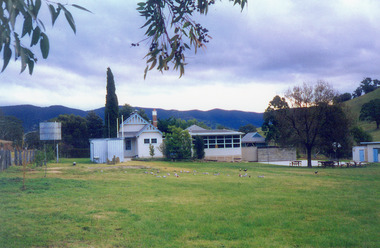
 Greensborough Historical Society
Photograph - Digital image, Ian Gilbert, Petrie Park 1960s, 1960s
Petrie Park Montmorency in the 1960s. The long drive can be seen with some children's play equipment. Today the park has a sports oval for cricket and football, a tennis court and lawn bowls as well as a children's playground. It is also the home of the Montmorency – Eltham RSL. The park is situated on Mountainview Road.Digital copy of black and white photo.petrie park montmorency, mountainview road montmorency -
 City of Ballarat
Artwork, other - Public Artwork, Col Henry, Spirit of the Forest by Col Henry, 2018
The artwork sought inspiration by the local history of Wendouree West and is a feature at the Wendouree West Recreation Reserve commissioned as part of a redevelopment of the park in 2017-2018. The artwork is located within close proximity to new playground facilities and promotes positive stories about Wendouree West to locals and the wider community.The artwork is of aesthetic significance to the people of BallaratThree stainless steel sculptures of Kurrajong tree leaves Col Henry 2018spirit of the forest, wendouree west, col henry, australian sculpture -
 Warrnambool and District Historical Society Inc.
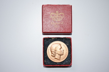
Medal, Queen Elizabeth 11 Coronation, 1953
This medal was issued in 1953 to commemorate the coronation of Queen Elizabeth 11 of Britain in 1953. It was issued by the National Playing Fields Association, an organization formed in 1925 to acquire, protect, improve and increase Britain’s playing fields and playgrounds. From 1947 to 2013 the Duke of Edinburgh was the President and in 2013 the Duke of Cambridge became the President.This medal has no known local provenance but it is retained for display purposes. .1 A bronze-coloured metal medal with the raised image of Qeen Elizabeth and printing on one side and four crowns and printing on the other side. .2 A rectangular-shaped red box with blue paper padding and a lid with some printing and the image of a crown. .1 Queen Elizabeth 11 crowned 2 June 1953 Issued by the National Playing Fields Association President H.R.H. The Duke of Edinburgh .2 Elizabeth R 1953 Coronation E11R 1953 Souvenir coronation of queen elizabeth 11, national playing fields association (britain), history of warrnambool -
 Melbourne Tram Museum
Photograph - Set of 7 postcard size photographs - Wattle Park MMTB, Melbourne & Metropolitan Tramways Board (MMTB), 1960s
Set of 7 photographs, probably by the MMTB of Wattle Park. 1 - Wattle Park Chalet building 2 - ditto - side view 3 - Children's playground area 4 - General view of the footpaths and park 5 - one of the water features 6 - View of some of the buildings. 7 - part of the golf course.Yields information about Wattle Park during the 1960s, which was owned and maintained by the MMTB.Set of 7 black and white photographs.tramways, mmtb, wattle park, golf -
 St Kilda Historical Society
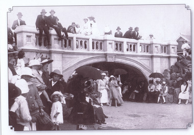
Photograph, Catani Arch, St Kilda Foreshore 1916, c.1916
St Kilda's Edge postcard showing people near the Catani Arch, St Kilda foreshoreblack and white postcard, original, unmountedSt Kilda's Edge. St Kilda foreshore, Melbourne's favourite seaside playground for 150 years. St Kilda's Edge is making sure it stays this way. Photo: Catani Arch, St Kilda Foreshore, Melburne, Australia, 1916. Port Phillip City Collection -
 Ringwood and District Historical Society
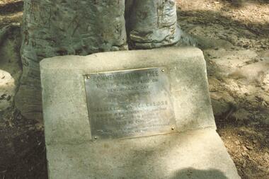
Photograph, Commemoration Tree Plaque, North Ringwood Primary School - circa 1990s
Commemoration Tree and plaque in the grounds of North Ringwood Primary School in Oban Road. These coloured photographs are undated, however the playground equipment suggests circa 1990s. The plaque mounted at the base of the tree in 1965 reflects the wording of a sign attached to the tree when it was planted ten years earlier, in 1955. (See also Reg. no. 139 - "Commemoration Tree"). Writing on plaque reads, "Commemoration Tree. This tree was planted on Remembrance Day 11th November 1955 by Maj. Gen. L.E. Beavis, C.B, CBE, DSO in memory of all servicemen who took part in the wars of 1914-18 and 1939-45. Lest We Forget. Presented by Ringwood Sub-branch R.S.S.A.I.L.A. 11th November 1965" -
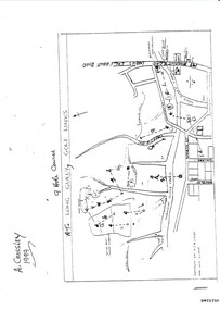 Bendigo Historical Society Inc.
Document - LONG GULLY HISTORY GROUP COLLECTION: THE LONG GULLY GOLF LINKS
Some history of the Long Gully Golf Links, a 9 Hole Course, by John Harvey. First page has a map of the area showing where the holes are and different features. There is a description of the tees and the route taken around the course.Dates when the Eaglehawk, Neangar park, Kangaroo Flat Golf Clubs and the Long Gully Playground were opened.bendigo, history, long gully history group, the long gully history group - the long gully golf links, a crossley, john harvey, long gully rec, dai gum san reservation, quarry hill golf club, bendigo golf club, marong gulf club, miss colgan, sacred heart cathedral choir, mechanics institute, rose of australia hotel, north hercules and energetic mine site, les thomas, tom austen, pearl south mullock heap, doc catford, clubs wearne, pearl mining co's diggings, pearl south, pearl east, bill and faye osterfield, ellen lee osterfield, eaglehawk gold club, neangar park golf club, f m fitzpatrick, kangaroo flat golf club, long gully playground, pearl sands, ennor brothers, birchmore brothers, shirley harvey, belvoir park, harold ennor, george ennor -
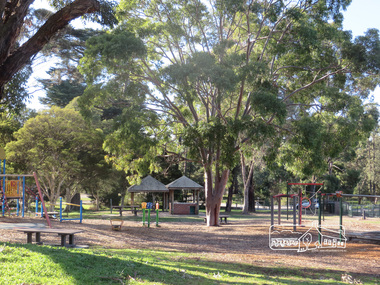
 Eltham District Historical Society Inc
Photograph, Eltham Town Park, 1985, 1985
Shire of Eltham Archives Series 13, Photograph Album, 1985. Originally contained in a 2-ring PVC binder and document sleevesNine sepia photographsseries 13, shire of eltham archives, alistair knox park, eltham town park, playground, markets, festival -
Greensborough Historical Society
Newsletter, Greenhills and North Greensborough Progress Association, Community News: official journal of the Greenhills and Nth. Greensborough Progress Association and the Apollo Parkways Progress Association. June 1978. Edition No. 5/78, 06/1978
Of mice, men & motorways, Diamond Valley Railway, Who runs your home? You or T.V.?, Real adventure playgrounds, The Montessori method, Septic tanks **!!***!!!, Depression, Kinder news, Nillumbik Historical Society, Karingal Tennis Club, Nursing Mothers Association, Parent Australia, From the Council Chamber, Montmorency & District Horticultural Society, This and that.Newsletter, 23 p., illus.greenhills and north greensborough progress association, greenhills, apollo parkways progress association, apollo parkways -
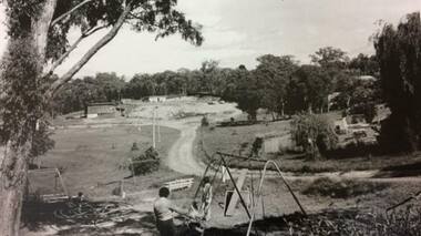
 Bendigo Historical Society Inc.
Photograph - VIEW OF MINING AREA - VICTORIA HILL
Black and white photograph. View overlooking north from Victoria Hill, mullock heaps, houses - some mid to late 20th century and some miner's cottages, formed road, children's playground centre foreground. Inscriptions: on back - purple rubber stamp 'Robert Wallace Studios, 6 Ruth Street, Golden Square, Phone Bgo 37565.Robert Wallaceplace, mining site, victoria hill, bendigo, mines and mining, landscape, mining landscape, mullock heaps -
 Sunbury Family History and Heritage Society Inc.
Photograph, Bulla Primary, 1994
There are a series of photographs in the collection which featured school improvements which were carried out on the building and the grounds in 1994 at the Bulla Primary School No. 46. The improvements included painting the school buildings, installing new playground equipment and laying our the school garden to include a vegetable garden. The first classroom to be built was a bluestone building, which opened in 1870. Two years after these improvements took place the Bulla Primary School was closed.A coloured photograph of one of the classrooms at the Bulla Primary School.bulla primary school, school improvements, school grounds