Showing 278 items
matching plenty - maps
-
 Greensborough Historical Society
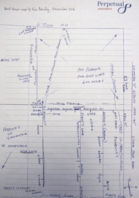
Book - Atlas, Victoria. Department of Sustainability and Environment, Melbourne atlas, 2006_
The purpose of the Melbourne Atlas is to give a spatial view of physical , environmental, social, economic and cultural aspects of Melbourne which can be used in planning. It contains maps and graphs depicting many aspects of life in Melbourne. A snapshot of life in Melbourne in 2006.Various paging, text, illus., colour maps. Wire binding.melbourne, maps, town planning, social conditions -
 Greensborough Historical Society
Book - Planning Document, TTM Consulting Pty Ltd, Greensborough District Centre: Structure plan, 1989, 1989_07
A summary of investigations into impacts of the Greensborough District Centre in 1989, with plans for the development of the East side of Main Street Greensborough.91 pages text and black and white line drawings. One colour fold out map. Black plastic binding and clear plastic cover. greensborough district centre, main street greensborough, greensborough plaza -
 Greensborough Historical Society
Book - Report, Ross King et al, Youth, leisure and public policy: the case of Diamond Valley, 1977, 1977_11
119 pages text and black and white line drawings and tables. One colour fold out map. White plastic binding. non-fictionshire of diamond valley, leisure activities, sport -
 Greensborough Historical Society
Book, Isabel Ellender, The Plenty Valley Corridor: the archaeological survey of Aboriginal sites / by Isabel Ellender 1991, 1991_
This archaeological survey of the Plenty Valley was conducted by Isabel Ellender in 1991 for the Board of Works (Melbourne Water), in particular the Plenty Gorge Metropolitan Park. The area studied is north of Greensborough to Whittlesea. A number of Aboriginal sites were identified and recommendations made for the future.67 p., illus., maps. Plastic spiral binding.plenty river, aboriginal heritage sites, plenty gorge metropolitan park -
 Greensborough Historical Society
Pamphlet, Friends of the Plenty River, "a beautiful stream": The Plenty River, 2004_04
A publicity pamphlet for "Friends of the Plenty River", a group formed in 1995 to help rehabilitate the Plenty River and adjacent land.2 p., illus., map. Tri-fold pamphlet.plenty river, lower plenty, friends of the plenty river -
 Greensborough Historical Society
Article, Gary Vines, Mills of the Plenty River, by Gary Vines, 2017_10
Transcript of conference paper on flour mills on the Plenty River, including Arthur Sergeantson's Carome Mill, George Coulstock's Janefield Mill and Moses Thomas's Mayfield Mill. The paper was presented at the 19th Australasian Engineering Heritage Conference in Mildura, October 2017Transcript of conference paper, 26 pages, illus. (some col.), maps.plenty river, flour mills -
![Map - Maps, [John Batman in Melbourne], 1976](/media/collectors/4f729f5697f83e03086015b8/items/60965f673c71fad916b3a651/item-media/60965fc33c71fad916b3a805/item-fit-380x285.jpg) Greensborough Historical Society
Greensborough Historical SocietyMap - Maps, [John Batman in Melbourne], 1976
... Plenty Lower Plenty melbourne Maps Map [John Batman in Melbourne ...Photocopies of 4 maps showing aspects of John Batman's time in Melbourne: Map of the settlement of the Yarra 1837; Batman's map of Port Phillip and his route of exploration, 1835, drawn by Wedge; Proposed route of Batman's initial exploratiion, and Enlargement of the Geelong region of Batman's map. No citations on any copy.Photocopy of maps, 4 pages.john batman, melbourne, port phillip -
 Greensborough Historical Society
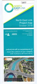
Leaflet, North East Link Authority, North East Link: project map October 2018, 2018_10
North East Link Authority was set up to lead development of this project. This map shows the proposed route with major intersections/interchanges. Map, colour text and images.north east link -
 Greensborough Historical Society
Map, Keelbundora. Counties of Bourke and Evelyn, 1950_11
... Plenty Lower Plenty melbourne Map Keelbundora. Counties of Bourke ...Covers area bounded by Merri Creek, Yarra River, Plenty River and Crown Portions 24 to 28, with section including Maroondah Aqueduct and Darebin Creek.Photocopy of digitised mapkeelbundora (parish) -
 Greensborough Historical Society
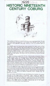
Leaflet, Coburg Historical Society, Historic nineteenth century Coburg, 1980s
A short history of 19th century Coburg, Victoria covering points of interest. Includes a map of the landmarks covered in the text. One page, printed on both sides in black and white text, drawings and photographs. Folded into 5. coburg (victoria), pentridge -
 Greensborough Historical Society
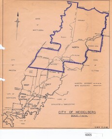
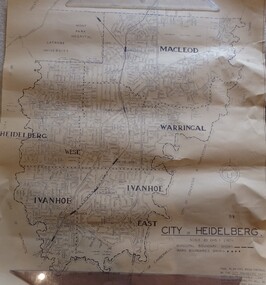
Map, City of Heidelberg, 1962, 02/02/1962
... Plenty Lower Plenty melbourne Map City of Heidelberg, 1962 Blue ...Map of City of Heidelberg showing boundaries of its six wards; North Ward is highlighted, covering Watsonia, Greensborough, part Bundoora, St Helena, Plenty, Yarrambat and Diamond Creek.Blue print mapCity of Heidelberg Scale: 1" to 1 ml. G.M.H. 2.2.62city of heidelberg, heidelberg - maps -
 Greensborough Historical Society
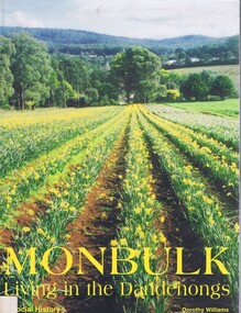
Book, Dorothy Williams, Monbulk: living in the Dandenongs, a social history, by Dorothy Williams, 1998_
History of Monbulk from early settlement in 1837 to 1997.Paperback, 325 p., black and white photographs, maps.monbulk, mount dandenong -
 Greensborough Historical Society
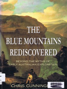
Book, Chris Cunningham, The Blue Mountains rediscovered: beyond the myths of early Australian exploration, by Chris Cunningham, 1996_
Written from both an historical and geographical view, this book tells the story of early inland exploration across the Blue Mountains.Paperback, 192 p., col. photographs, black and white maps.blue mountains nsw -
 Greensborough Historical Society
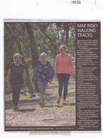
Newspaper Clipping, Diamond Valley Leader, Map risky walking tracks, 29/03/2017
... Plenty Lower Plenty melbourne Newspaper Clipping Map risky ...Walkers are being urged to dob in dubious walking tracks in a bid to attract funding for improvements.News article 1 page, black text, colour image.walking tracks, walkspot project, womens walking wanderers -
 Greensborough Historical Society
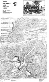
Map, Dennis Ward, John Batman's 1835 Treaty Trail on the Plenty River, 2010_
... Map of the Plenty River through Greensborough... Plenty Lower Plenty melbourne Map John Batman's 1835 Treaty Trail ...Map of the Plenty River through Greensborough and surrounding areas, annotated with historic places. Prepared by Dennis Ward, this map shows places of interest with historic markers for a proposed Heritage Trail along the Plenty. This was a joint project of Dennis Ward, Rotary Greensborough and Nillumbik Historical Society.This map shows many places of interest along the Plenty River. Large laminated map, including land subdivisions and street names.plenty river heritage trail -
 Greensborough Historical Society
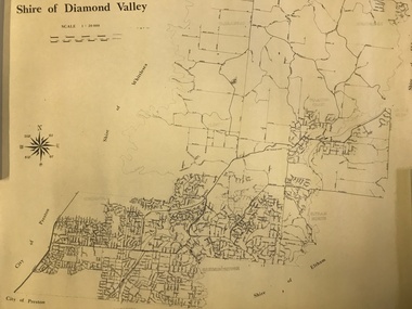
Map, Shire of Diamond Valley, 1964-1994
... Plenty Lower Plenty melbourne Map Shire of Diamond Valley Map ...Map of the former Shire of Diamond Valley, 1964-1994, showing the local government area from Greensborough to Hurstbridge.Map on yellowed paper.shire of diamond valley, greensborough, hurstbridge -
 Greensborough Historical Society
Map, Victoria. Department of Crown Lands and Survey, Keelbundoora; Counties of Bourke and Evelyn, 1950c
... Plenty Lower Plenty melbourne Map Keelbundoora; Counties ...Map of the Victorian counties of Bourke and Evelyn showing parish boundaries and land ownership.Show the original landholders for this area.Map on light brown parchment, covered in plastic."L.5305" and "3462" -
 Greensborough Historical Society
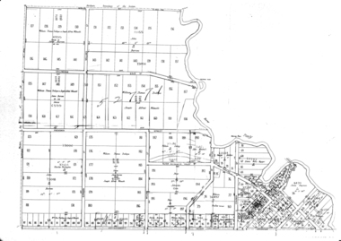
Map, Green's subdivision of Greensborough, 1860c
... Plenty Lower Plenty melbourne Map Green's subdivision ...This map shows the original subdivision of Greensborough by Edward Bernard Green. Some street names are different to today. This map shows the plan on which the town of Greensborough was based.Copy of early map showing subdivision of Greensborough. Black ink on white paper.edward bernard green, greensborough -
 Greensborough Historical Society
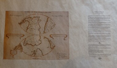
Map, Mapping Authority of NSW, Terra Australis: Quinta Pars Orbis, 1676_
... Plenty Lower Plenty melbourne Map Terra Australis: Quinta Pars ...The original of this map was drawn by an Italian priest Father Victorio Riccio in 1676 from knowledge brought to Manila on Dutch ships. Father Riccio was suggesting a Catholic mission to Terra Australia.Reproduction of an early map of Australia, pre-dating the voyages of Captain Cook.Facsimile map in cardboard protective tubeterra australis -
 Greensborough Historical Society
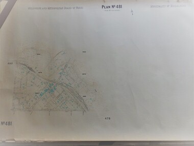
Map, Melbourne & Metropolitan Board of Works, MMBW Plan No.481, 23/09/1949
... Plenty Lower Plenty melbourne Map MMBW Plan No.481 MMBW plan ...MMBW plan of part of central Greensborough, Main Street and surrounds, from sports ovals in North to Grimshaw Street in South.Map shows buildings and topography for the area.MMBW plan, black and colour ink on beige parchment, 2 copies."Scale:160 feet to 1 inch"melbourne and metropolitan board of works, mmbw, greensborough -
 Greensborough Historical Society
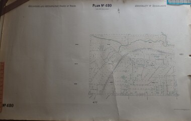
Map, Melbourne & Metropolitan Board of Works, MMBW Plan No.480, 17/10/1949
... Plenty Lower Plenty melbourne Map MMBW Plan No.480 MMBW plan ...MMBW plan of part of central Greensborough, from Plenty River in North to Grimshaw Street in South, Sellars Street in West to Kerr Street in East.Map shows buildings and topography for the area.MMBW plan, black and colour ink on beige parchment, 4 copies."Scale:160 feet to 1 inch"melbourne and metropolitan board of works, mmbw, greensborough -
 Greensborough Historical Society
Map, City of Heidelberg. Engineers Dept, City of Heidelberg, 1960s
... Plenty Lower Plenty melbourne Map City of Heidelberg Map showing ...Map of the City of Heidelberg from the Yarra River in the South to North of Watsonia Military Camp. Shire of Diamond Valley is shown to the north.Map showing municipal and ward boundaries, black text on light brown paper."Scale: 20 CHS = to 1 IN"city of heidelberg -
 Greensborough Historical Society
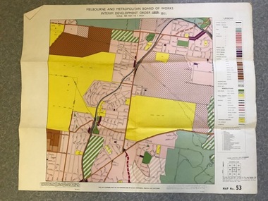
Map, Melbourne and Metropolitan Board of Works Interim Development Order 1961 Map No. 53, 27/09/1961
... Plenty Lower Plenty melbourne Map Melbourne and Metropolitan ...Denotes Zones and Reservations comprising part of the municipalities of Eltham, Heidelberg, Preston and Whittlesea, approved 27.9.61. Includes Mont Park Hospital and Watsonia Military Camp.Colour plan Date printed on plan (1959) has been over stamped with 1961. Also stamped with Government Gazette date of 27.9.1961. "Scale 800 feet to 1 inch"greensborough, watsonia -
 Greensborough Historical Society
Map - Digital Image, Eric Barclay's Grace Park map, November 2016, 2016_11
... Plenty Lower Plenty melbourne Map - Digital Image Eric Barclay's ...Eric Barclay's Grace Park map, November 2016. Eric recalls the area around Grace Park from the late 1940s.Digital copy of black and white maperic barclay, barclay family, grace park -
 Greensborough Historical Society
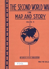
Book, Neville Smith, The Second World War in Map and Story, volume 4, ed. by Neville Smith, 1944_07
Series of articles published by the "Argus" 1941-1945, dealing with events and campaigns in World War 2.48 p., col. maps.world war 2 -
 Greensborough Historical Society
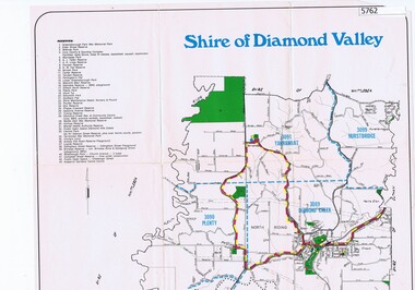
Map, Map - Shire of Diamond Valley, 1990c
... Plenty Lower Plenty melbourne Map Map - Shire of Diamond Valley ...Map issued by the Shire of Diamond Valley showing location of key organisations and features Map printed in colour, one sideshire of diamond valley -
 Greensborough Historical Society
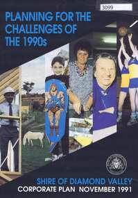
Pamphlet, Planning for the challenges of the 1990s: Shire of Diamond Valley Corporate Plan, 1991_11
Shire of Diamond Valley Corporate Plan 1991. Includes Shire map and statistics with plans for services to the community.16p. text and coloured photographsshire of diamond valley -
 Greensborough Historical Society
Article, Dawn Bennetts (nee Petts), Eltham Community Market, 1978o
A history of the Eltham Community Market by stallholder Dawn Bennetts. The Market began in 1978 and Dawn joined in 1985.7 typed pages, col. illus. and maps.eltham community market, dawn bennetts -
 Greensborough Historical Society
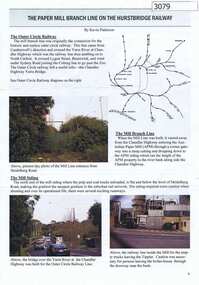
Article, Journal, Keith Patterson, The Paper Mill branch line on the Hurstbridge Railway, by Kevin Patterson, 2012_12
A branch line from the Outer Circle Line was built for the delivery of coal and paper pulp to the Australian Paper Mill at Fairfield. It operated as a branch from the Hurstbridge line until the 1970s, when the Australian Paper Mill plant changed to power by Bass Strait oil. 3 p., text , map and coloured photographs, pp. 4-6 of Nillumbik Custodian December (?) 2012husrstbridge railway line, outer circle railway line, australian paper mill -
 Greensborough Historical Society
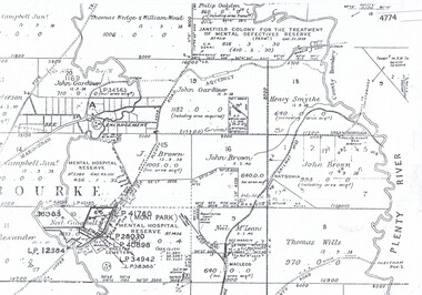
Maps, Greensborough west of Plenty River, 1840o
... Plenty Lower Plenty melbourne Maps Greensborough west of Plenty ...Areas of Greensborough, west of the Plenty River, showing land holdings in the 1840s. Comprises Sections 8, 9, 10, 14, 15, 16, 17, 18, 19, 20 Parish of KeelbundoraOne A4 photocopy, one A3 enlargementgreensborough, watsonia, lower plenty, janefield