Showing 215 items
matching plenty river bridge
-
 Eltham District Historical Society Inc
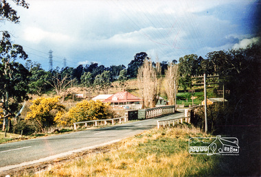
Photograph, Old Lower Plenty Bridge and Hotel
Colour photograph of Lower Plenty Bridge from the west prior to opening of new bridge. Hotel in background. 4 x 6 print and also laminated 8 x 10 print.lower plenty, main road, plenty river, golf club hotel, hotels, bridges -
 Eltham District Historical Society Inc
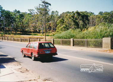
Photograph, Main Road Bridge, Lower Plenty
Colour photographbridges, lower plenty, main road, plenty river -
 Eltham District Historical Society Inc
Photograph, Doug Orford, Lower Plenty Bridge, Old Eltham Road, Lower Plenty, 1998
... River Trail. bridges lower plenty main road plenty river Old ...Originally the boundary between the former Shire of Eltham and the City of Heidelberg, a toll gate existed on the Eltham side. The bridge has since been restored and is now part of the Plenty River Trail.Two colour photograph prints 10 x 15 cm (2 copies)bridges, lower plenty, main road, plenty river, old eltham road -
 Eltham District Historical Society Inc
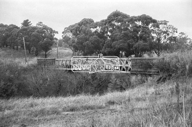
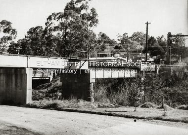
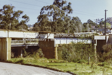
Photograph, Para Road Bridge construction, Briar Hill, near Greensborough, c.1971, 1971c
... works of the bridge over the Plenty River at Briar Hill and one... construction works of the bridge over the Plenty River at Briar Hill ...Three black and white photographs; two showing construction works of the bridge over the Plenty River at Briar Hill and one of Greensborough Park, Grimshaw Street, summer 1971-1972greensborough, briar hill, para road, bridges, construction, plenty river -
 Eltham District Historical Society Inc
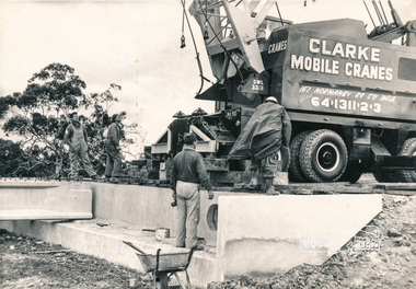
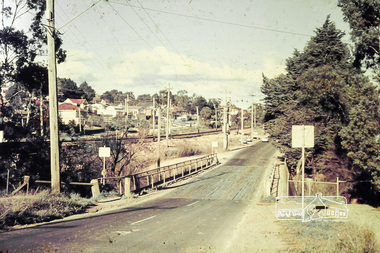
Photograph, Construction of Lower Plenty Bridge, Main Road, c.August 1966, 1966
Black and white photograph of construction of northern Lower Plenty Bridge 1969bridges, bridge construction, main road, lower plenty, plenty river, cranes -
 Eltham District Historical Society Inc
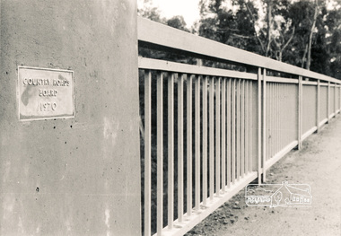
Photograph, Lower Plenty Bridge, 1970, 1970
Black and white photograph showing the hand rail and plaque 'Country Road Board 1970'bridges, main road, lower plenty, plenty river -
 Eltham District Historical Society Inc
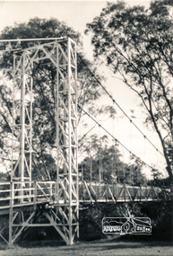
Photograph, Pedestrian suspension bridge over the Yarra River at Lower Plenty
Odyssey House drug rehabilitation centre in Bonds Road, Lower Plenty is a distinctive landmark, especially when viewed from across the Yarra at Templestowe. It was built in the 1950’s as a seminary for the Blessed Sacrament Fathers. Because of the poor and circuitous road access, a suspension footbridge was built across the river. As well as providing easy access for the priests residents of Templestowe could attend services at the seminary. The bridge is now part of the Yarra Trails system.Two black and white photographs of footbridge over Yarra River, part of the Ruffey Trail just off the Main Yarra Trail near the former seminary (now Odyssey House) Lower Plentybridges, yarra river, odyssey house, bonds road, lower plenty, seminary, blessed sacrament fathers -
 Eltham District Historical Society Inc
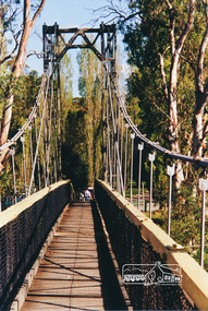
Photograph, Pedestrian suspension bridge over the Yarra River at Lower Plenty
... . bridges yarra river lower plenty seminary blessed sacrament ...Odyssey House drug rehabilitation centre in Bonds Road, Lower Plenty is a distinctive landmark, especially when viewed from across the Yarra at Templestowe. It was built in the 1950’s as a seminary for the Blessed Sacrament Fathers. Because of the poor and circuitous road access, a suspension footbridge was built across the river. As well as providing easy access for the priests residents of Templestowe could attend services at the seminary. The bridge is now part of the Yarra Trails system.Colour photograph of footbridge over Yarra River, part of the Ruffey Trail just off the Main Yarra Trail near the former seminary (now Odyssey House) Lower Plentybridges, yarra river, lower plenty, seminary, blessed sacrament fathers, odyssey house, bonds road -
 Eltham District Historical Society Inc
Negative - Photograph, Warrandyte Bridge over River Yarra, c.1910
View of the 1875 timber trestle bridge over the Yarra River reproduced from a newsprint image. Also known as Anderson's Creek (Road) Bridge A contract was accepted for William Elliot to erect a bridge over the Yarra River at Warrandyte on Anderson's Creek Road and other improvements for £1,331.6.2 - Gazette No. 143. Tuesday, November 13th 1860 - http://gazette.slv.vic.gov.au/view.cgi?year=1860&class=general&page_num=2161&state=V&classNum=G143&id=). The bridge was washed away by floods in 1863. It was replaced with a taller timber trestle structure in October 1875, designed and built by C.S. Wingrove, Shire Clerk, Engineer and Surveyor for Eltham Shire Council. A replacement for this bridge was commenced in 1955 to cope with increasing traffic and this structure was widened in 2018 to meet further traffic demands. Argus (Melbourne, Vic. : 1848 - 1957), Thursday 23 September 1875, page 7 ________________________________________ THE WARRANDYTE BRIDGE. The ceremony of formally opening the newly erected bridge over the Yarra at Ander-son's Creek was performed on Monday last, in the presence of the members of the Eltham and Bulleen shire councils whose territories it joins, and a goodly number of the residents of the district. The task was delegated to Mr. Cameron, M.L.A., who, after a few introductory remarks declared the bridge to be opened, and christened it the " Warrandyte Bridge." The party then adjourned to Grant's Hotel, where a cold collation had been prepared. The chair was taken by the president of the Eltham shire (Mr. John Bell) and the vice chair by Mr. Kent, a member of the Bulleen council. Mr Robert Williamson proposed "Success to the bridge," coupling with it the name of Mr. Cameron, to whose exertions was in the main to be attributed the erection of that structure which was an ornament to the district and would prove of great service to both sides of the river. Mr. Cameron, in responding, alluded to the great difficulties, mainly of a pecuniary nature, that had been encountered in carrying out the project, and which had only been got over by their united efforts and by the liberal spirit in which the late Commissioner of Roads had dealt with the case. The healths of the contractor and the engineer were also drunk. The bridge is a trussed timber one, resting on yellow box piles sunk into the solid rock, each pier being weighted with 50 tons of stone. The abutments consist of dry stone walls, 6ft. thick at the base, and tapering to 3ft. on the top, the face of the work having a batter of 1 to 1. The length of the bridge is 308ft., there being four openings in the centre of 66ft. each, and two at the ends of 20ft. each. The width in the clear is 9½ft., and the height from the bed of the river about 33ft. The approaches comprise 1,100 cubic yards of earthwork, and the formation of 48 chains of sideling, the whole cost of the work, which was carried out under the direction of the engineer to the Eltham Shire Council, being £1,413.This photo forms part of a collection of photographs gathered by the Shire of Eltham for their centenary project book,"Pioneers and Painters: 100 years of the Shire of Eltham" by Alan Marshall (1971). The collection of over 500 images is held in partnership between Eltham District Historical Society and Yarra Plenty Regional Library (Eltham Library) and is now formally known as the 'The Shire of Eltham Pioneers Photograph Collection.' It is significant in being the first community sourced collection representing the places and people of the Shire's first one hundred years.Digital image 4 x 5 inch B&W Neg B&W Print 12.5 x 9 cmsepp, shire of eltham pioneers photograph collection, warrandyte, bridge -
 Eltham District Historical Society Inc
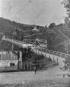
Photograph, Warrandyte Bridge on River Yarra
Bridge across the Yarra River which links North Warrandyte and Warrandyte. A house sits prominantly on a hill in the distance. A wooden building on the side of the road before the bridge has advertising for Wardrop Tailor, Smith Street, Collingwood. It is suggested that the photo has had this fake information added at a later date. Wardrop Tailor did operate from about 1915 to 1921. Alternataive title: Warrandyte Bridge - River Yarra. "Wardrop-Tailor, Smith St. C'wood" sign - faked?This photo forms part of a collection of photographs gathered by the Shire of Eltham for their centenary project book,"Pioneers and Painters: 100 years of the Shire of Eltham" by Alan Marshall (1971). The collection of over 500 images is held in partnership between Eltham District Historical Society and Yarra Plenty Regional Library (Eltham Library) and is now formally known as 'The Shire of Eltham Pioneers Photograph Collection.' It is significant in being the first community sourced collection representing the places and people of the Shire's first one hundred years.Digital imagesepp, shire of eltham pioneers photograph collection, warrandyte, bridge, north warrandyte, yarra river, wardrop tailor, collingwood -
 Eltham District Historical Society Inc
Photograph, Eltham - Floods in 1934
To the left of picture is the Main Road Bridge over the Diamond Creek in Eltham South when the Diamond Creek was in flood. The Yarra also was in flood. In early December 1934 the "Greatest flood in the history of the Yarra" occured, according to The Argus newspaper. Bridges and houses were swept away with hundreds of people left homeless across the state. The historic 1934 flood of the Diamond Creek and Yarra River set the criteria for future planning with respect to flood water rise.This photo forms part of a collection of photographs gathered by the Shire of Eltham for their centenary project book, "Pioneers and Painters: 100 years of the Shire of Eltham" by Alan Marshall (1971). The collection of over 500 images is held in partnership between Eltham District Historical Society and Yarra Plenty Regional Library (Eltham Library) and is now formally known as 'The Shire of Eltham Pioneers Photograph Collection.' It is significant in being the first community sourced collection representing the places and people of the Shire's first one hundred years.Digital image 4 x 5 inch B&W Negsepp, shire of eltham pioneers photograph collection, eltham, diamond creek (river), 1934 flood, diamond creek, floods, main road bridge -
 Eltham District Historical Society Inc
Photograph, Floodwaters, Diamond Creek, Eltham, 1934
The Diamond Creek in flood near the Main Road bridge at Eltham, Victoria. The Yarra also was in flood. In early December 1934 the "Greatest flood in the history of the Yarra" occured, according to The Argus newspaper. Bridges and houses were swept away with hundreds of people left homeless across the state. The historic 1934 flood of the Diamond Creek and Yarra River set the criteria for future planning with respect to flood water rise.This photo forms part of a collection of photographs gathered by the Shire of Eltham for their centenary project book, "Pioneers and Painters: 100 years of the Shire of Eltham" by Alan Marshall (1971). The collection of over 500 images is held in partnership between Eltham District Historical Society and Yarra Plenty Regional Library (Eltham Library) and is now formally known as 'The Shire of Eltham Pioneers Photograph Collection.' It is significant in being the first community sourced collection representing the places and people of the Shire's first one hundred years.Digital image 4 x 5 inch B&W Neg (2 frames on one neg) 9 x 15.5 cm B&W printflooding, eltham, shire of eltham pioneers photograph collection, sepp, diamond creek (river), floods, 1934 flood, diamond creek -
 Eltham District Historical Society Inc
Photograph, Odyssey House Victoria, 28 Bonds Road, Lower Plenty, 6 March 1990
Odyssey House drug rehabilitation centre in Bonds Road, Lower Plenty is a distinctive landmark, especially when viewed from across the Yarra at Templestowe. It was built in the 1950’s as a seminary for the Blessed Sacrament Fathers. Because of the poor and circuitous road access, a suspension footbridge was built across the river. As well as providing easy access for the priests residents of Templestowe could attend services at the seminary. The bridge is now part of the Yarra Trails system.Colour photographlower plenty, bonds road, odyssey house -
 Eltham District Historical Society Inc
Negative - Photograph, Russell Yeoman, Para Road / Carter Street Bridge over the Plenty River, Briar Hill, c.Jul. 1969
... Para Road / Carter Street Bridge over the Plenty River...Bridge over the Plenty River at Briar Hill before widening... melbourne Bridge over the Plenty River at Briar Hill before widening ...Bridge over the Plenty River at Briar Hill before widening and alterations. The Plenty River at Briar Hill represented the boundary between the Shire of Eltham and the Shire of Diamond Valley. The bridge was known as the Carter Street Bridge as prior to 1969 Para Road, Briar Hill became Carter Street, Greensborough across the river. It was at this time that the name Para Road was continued and replaced Carter Street.This photo forms part of a collection of photographs gathered by the Shire of Eltham for their centenary project book,"Pioneers and Painters: 100 years of the Shire of Eltham" by Alan Marshall (1971). The collection of over 500 images is held in partnership between Eltham District Historical Society and Yarra Plenty Regional Library (Eltham Library) and is now formally known as the 'The Shire of Eltham Pioneers Photograph Collection.' It is significant in being the first community sourced collection representing the places and people of the Shire's first one hundred years.Digital image 35 mm B&W negativeshire of eltham pioneers photograph collection, briar hill, 1969-07, bridge, carter street bridge, para road, para road bridge, plenty river, shire of diamond valley, shire of eltham -
 Eltham District Historical Society Inc
Negative - Photograph, Carl Walter 1831-1907, Coffer dam in the Yarra River at Anderson's Creek, 1864
1864 photograph of the Coffer Dam in the River Yarra situated (approximately) opposite Whipstick Gully. Remains of bridge built in 1860(?) wrecked by 1863 flood in background. Reproduced page 29 of ‘Pioneers & Painters’ Gold was first discovered in this area at Andersons Creek (Warrandyte) in June 1851 by Louis Michel. Discoveries north of the Yarra did not occur until about 1854. Although it took some months for a true rush to develop it was not long before alluvial workings were being carried on in most of the Shire of Eltham. The last area in which gold was discovered was Kinglake. As the gold became harder to find, deep mining took over from alluvial diggings in the gullies. Perhaps the most extensive of the deep workings was the Diamond Creek Mine just outside the boundary of the Shire. This form of mining was continued into the 1930s. There are believed to be some mines in the area still capable of producing gold but present prices make working these uneconomical. Some gold is still found by weekend prospectors. Photo: Carl Walter 1831-1907 – inscribed on tent “C. Walter Photo” The State Library of Victoria holds over 150 photos by Carl Walter, most of which are portraits of Aboriginal natives including William Barak.This photo forms part of a collection of photographs gathered by the Shire of Eltham for their centenary project book,"Pioneers and Painters: 100 years of the Shire of Eltham" by Alan Marshall (1971). The collection of over 500 images is held in partnership between Eltham District Historical Society and Yarra Plenty Regional Library (Eltham Library) and is now formally known as 'The Shire of Eltham Pioneers Photograph Collection.' It is significant in being the first community sourced collection representing the places and people of the Shire's first one hundred years.Digital image 4 x 5 inch B&W Neg (2) Print 20 x 25 cmshire of eltham pioneers photograph collection, anderson's creek, coffer dam, floods, gold mining, other areas, pioneers and painters, warrandyte, warrandyte bridge, yarra river -
 Eltham District Historical Society Inc
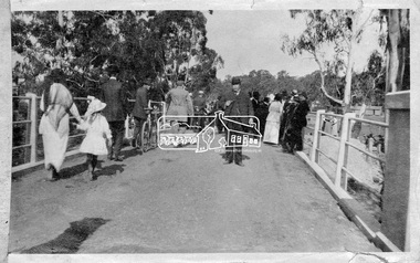
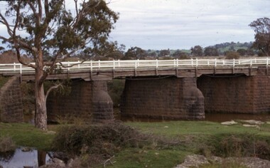
Photograph, Hurstbridge - Cr. Price crossing New Bridge (Opening Day), 1917, 1917
Eltham Shire Councillor Albert Price joined over 500 spectators for the official opening of the new re-inforced concrete bridge across the Diamond Creek at Hurstbridge. Eltham Shire shared the cost of the construction of the bridge with Heidelberg and Whittlesea Shires.This photo forms part of a collection of photographs gathered by the Shire of Eltham for their centenary project book, "Pioneers and Painters: 100 years of the Shire of Eltham" by Alan Marshall (1971). The collection of over 500 images is held in partnership between Eltham District Historical Society and Yarra Plenty Regional Library (Eltham Library) and is now formally known as 'The Shire of Eltham Pioneers Photograph Collection.' It is significant in being the first community sourced collection representing the places and people of the Shire's first one hundred years.Digital imagesepp, shire of eltham pioneers photograph collection, diamond creek, hurstbridge, wattle glen, bridge, councilor price, opening day, diamond creek (river) -
 Eltham District Historical Society Inc
Negative - Photograph, J. P. Lind, Hurst's Bridge, 1885
Looking northwest onto the first bridge at Hurstbridge, 1885. Timber bridge amid rural setting. Two horses graze in an open paddock in the foreground. A house is situated on a rise behind the bridge on a tree lined hill. The area of Hurstbridge was originally known as Hurst’s-bridge after the timber bridge built over the Diamond Creek near Hurst’s station in late 1881/early 1882 on the Hurstbridge-Arthurs Creek Road, Hurstbridge. It was built by John McDonald, of Arthur's Creek and was demolished and replaced in 1917 by a reinforced concrete arch bridge designed by John Monash. Cross Reference Photo No.(s): 1012/1013This photo forms part of a collection of photographs gathered by the Shire of Eltham for their centenary project book, "Pioneers and Painters: 100 years of the Shire of Eltham" by Alan Marshall (1971). The collection of over 500 images is held in partnership between Eltham District Historical Society and Yarra Plenty Regional Library (Eltham Library) and is now formally known as 'The Shire of Eltham Pioneers Photograph Collection.' It is significant in being the first community sourced collection representing the places and people of the Shire's first one hundred years.Digital image 4 x 5 inch B&W Negshire of eltham pioneers photograph collection, hurstbridge, bridge, diamond creek (river), diamond creek (creek), hurst's bridge -
 Eltham District Historical Society Inc
Photograph, Footbridge across Plenty River, Montmorency (leading to Plenty Lane, Greensborough)
... melbourne infrastructure bridge Footbridge Montmorency plenty river ...Black and white photographinfrastructure, bridge, footbridge, montmorency, plenty river -
 Eltham District Historical Society Inc
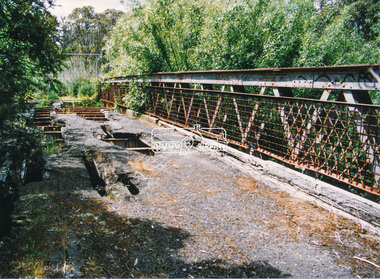
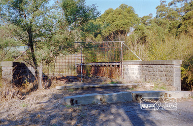
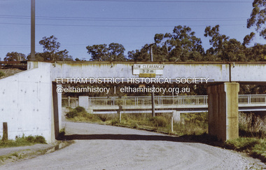
Negative - Photograph, Old Lower Plenty Bridge, 18 Apr 1998
... iron bridge at Lower Plenty - now re-opened and used ...EDHS Autumn excursion to Lower Plenty area The blocked-off iron bridge at Lower Plenty - now re-opened and used as a footway/bike path section joining the Yarra River path.Roll of 35mm colour negative film, 2 strips and associated colour printKodak Gold 200-6activities, lower plenty bridge, autumn excursion, eltham district historical society, lower plenty -
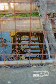 Eltham District Historical Society Inc
Negative - Photograph, Old Lower Plenty Bridge, 18 April 1998
... melbourne Plenty River reflections through the old iron Lower Plenty ...Plenty River reflections through the old iron Lower Plenty Bridge; Autumn Excursion to Lower Plenty area. The blocked-off iron bridge at Lower Plenty - now re-opened and used as a footway/bike path section joining the Yarra River path.Roll of 35mm colour negative film, 2 strips and associated colour printKodak Gold 200-6activities, lower plenty bridge, autumn excursion, eltham district historical society, lower plenty -
 Eltham District Historical Society Inc
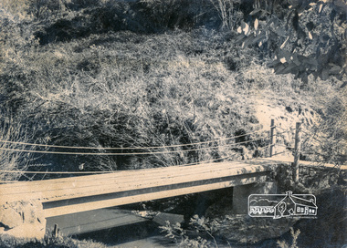
Negative - Photograph, Russell Yeoman, Old Lower Plenty Bridge, c.1970
... Old bridge across the Plenty River at Lower Plenty now part... melbourne Old bridge across the Plenty River at Lower Plenty now ...Old bridge across the Plenty River at Lower Plenty now part of the Plenty River Trail. Part of a slide show presentation "Bridges & Waterways of the Shire" by Russell Yeoman to the 13 September 1989 Society meeting. The presentation included slides of historic photos from the Shire of Eltham Pioneers collections as well as several recent views.Roll of 35mm black and white negative film, 4 of 7 stripsIlford HP4bridge, lower plenty, main road, plenty river, plenty river trail -
 City of Whittlesea
Photograph - Photographs - Bridges, Moses Thomas bridge over the Plenty River 1970, 1970
... Moses Thomas bridge over the Plenty River 1970...Bluestone bridge across the Plenty River, Mernda... bridge across the Plenty River, Mernda. Commissioned by Moses ...Bluestone bridge across the Plenty River, Mernda. Commissioned by Moses Thomas, Secretary Morang District Road Board 1867bridges, moses thomas, mernda, bridge inn road -
 Eltham District Historical Society Inc
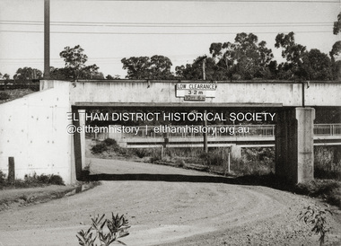
Photograph - Black and White Print, Railway Bridge across Plenty River near Railway Road, Briar Hill, Vic, c. August 1977
... Railway Bridge across Plenty River near Railway Road, Briar...Para Road bridge across Plenty River can be seen behind...Para Road bridge across Plenty River can be seen behind ...Para Road bridge across Plenty River can be seen behind railway bridge.Black and white photographinfrastructure, bridge, greensborough, para road bridge, railway road bridge, shire of eltham infrastructure -
 Eltham District Historical Society Inc
Photograph - Colour Print, Railway Bridge across Plenty River near Railway Road, Briar Hill, Vic, c. August 1977
... Railway Bridge across Plenty River near Railway Road, Briar...Para Road bridge across Plenty River can be seen behind...Para Road bridge across Plenty River can be seen behind ...Para Road bridge across Plenty River can be seen behind railway bridge.Colour photographinfrastructure, bridge, greensborough, para road bridge, railway road bridge, shire of eltham infrastructure -
 Eltham District Historical Society Inc
Photograph, Russell Yeoman, Para Road (Carter Street) Bridge over the Plenty River, Briar Hill, Vic, 1970s
... Para Road (Carter Street) Bridge over the Plenty River... the Plenty River, Briar Hill, Vic. Photograph Russell Yeoman ...Digital file only; created from original colour positive slide transparencystreets, para road, carter street, bridge, railway line, russell yeoman collection -
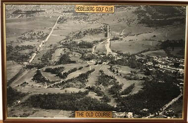 Heidelberg Golf Club
Photograph - Framed Photograph, Heidelberg Golf Club: The old course, 1966c
... bridge over the Plenty River). Known as the 'old course... the Plenty River). Known as the 'old course' it was designed by Harry ...An aerial photograph of the Heidelberg Golf Course, around 1966 (this date is taken from the road work to build the new bridge over the Plenty River). Known as the 'old course' it was designed by Harry Alexander and was in play until a redesign of the course in 1968. The clubhouse is in top centre of photograph.One of several aerial photogrphs showing the layout of the Heidelberg Golf CourseLarge Black and white aerial photograph, timber frame. Brass plaque top and bottom."Heidelberg Golf Club" "The old course"heidelberg golf club, old course -
 Greensborough Historical Society
Newsletter, Greenhills and North Greensborough Progress Association, Community News: official journal of the Greenhills and Nth. Greensborough Progress Association and the Apollo Parkways Progress Association. 12th September, 1977. Edition No. 8/77, 12/09/1977
... on the Plenty River, Scout news, Diamond Valley Arts Society. A digital... on the Plenty River, Scout news, Diamond Valley Arts Society. A digital ...You could be the first [private swimming pool safety], Swimming pool safety debate, Market to market, In Diamond Valley, we commission our commissioner - Brian Waters, This and that, Children's Week, From the Council Chamber, Nillumbik Historical Society: history at Apollo Parkways - The Siphon Bridge on the Plenty River, Scout news, Diamond Valley Arts Society. A digital copy of this Newsletter is available from Greensborough Historical Society.Newsletter, 24 p., illus.greenhills and north greensborough progress association, greenhills, apollo parkways progress association, apollo parkways -
 Eltham District Historical Society Inc
Photograph - Digital Photograph, Alan King, Nillumbik Shire Offices, Greensborough, 30 March 2008
Nillumbik Shire Council transferred to the former Diamond Valley Shire Offices in Greensborough after municipal restructuing. The offices became the official Nillumbik Shire Council Offices on 16 October 1995. The former Shire of Diamond Valley Civic Centre or Shire Office building was officially opened on 26th February 1972. Archtiects were A.K. Lines, McFarlane & Marshall and it was built by L.U. Simon Pty Ltd, The Diamond Valley Shire had been created in 1964 from part of the City of Heidelberg. On December 15, 1994 the Shire of Nillumbik was established. Under the Council amalgamations imposed by the Kennett government, the Shire of Eltham, Shire of Diamond Valley and City of Heidelberg ceased to exist with the establishment of Nillumbik Shire Council and the City of Banyule.The new Nillumbik shire surrended the west riding from Eltham to Banyule but in place gained parts of the former Diamond Valley Shire which itself had been created in 1964 from parts of the City of Heidelberg. Three unelected and non-local Commissioners were put in place by the government bringing democracy into question by many members of the local community. The Commissioners determined to abandon the former Shire of Eltham offices located in Main Road, Eltham and in turn occupy the former Shire of Diamond Valley offices located at the boundary of the new shire with Banyule, in Civic Drive, Greensborough. In July 1996 the Commissioners sold the former Eltham Shire Offices and had them bulldozed leading to many years of communiity protest over the process and future development applications. The site has remained vacant ever since. Published: Nillumbik Now and Then / Marguerite Marshall 2008; photographs Alan King with Marguerite Marshall.; p43 It was the need for roads that led to this district’s first council. In 1853 a committee was formed to improve the rough roads, some in Kangaroo Ground being almost impassable in winter.1 The committee fundraised by voluntary levies and grants to improve in particular, the main road between Kangaroo Ground and the Plenty River. From this committee arose the Eltham District Road Board, in 1856, which was the precursor to the Eltham Shire Council. The Board’s first chairman was Kangaroo Ground farmer, John Barr. Secretary was the former committee’s secretary, Andrew Ross, Kangaroo Ground’s first school teacher, and founder of the district newspaper, The Evelyn Observer.2 Most of the board’s income came from a toll-house north of the Lower Plenty Bridge, which funded such projects as a road from Kangaroo Ground to the Caledonia Diggings. In 1871 the Shire of Eltham was proclaimed, with its boundaries the same as those of the Road Board, and Councillor A Donaldson of Kangaroo Ground was the first president. Eltham was at the southern tip of the shire, which extended north to Kinglake and east beyond Yarra Glen. In 1878, part of Kinglake was added to the shire, while the area east of Watts River, near Healesville was removed. In 1912, then again in 1958, the shire was further reduced. Yarra Glen, Steels Creek, Tarrawarra, parts of Healesville and Christmas Hills, were transferred to the Shire of Healesville. In 1972 a smaller area, at Kinglake, was transferred to the Shire of Yea, leaving 277 square kilometres in the Eltham Shire. Perhaps no other Victorian municipality has had so many meeting places. Although from 1858 to 1904, the council convened at the office in the home of Secretary Charles Wingrove, the board, and later the council, also met at other more central locations.3 The board moved from the Fountain of Friendship Hotel to the Eltham Courthouse, to the Kangaroo Ground schoolhouse. It then met at the Kangaroo Ground Hotel, which some considered put it in danger of interruptions by people ‘the worse for liquor’.4 In 1885 the council met at the hall on Mr J Donaldson’s land at Kangaroo Ground. After Wingrove’s retirement, the council rented space at the Kangaroo Ground General Store and Post Office. Then, in 1917, the council bought the former office of The Evelyn Observer, after its printing works transferred to Hurstbridge. In 1934, fire destroyed the shire office, which was temporarily relocated to the Kangaroo Ground home of Shire Secretary, Mr P J McMahon. In 1941, the shire office moved to a new building (which included a public hall) in Eltham, at the corner of Arthur Street and Main Road, where the Eltham Village Shopping Centre was eventually built. Growth required new offices, which opened in 1965, on the former Shillinglaw property in Main Road.5 In 1994, as part of municipal restructuring under the Jeff Kennett Liberal Government, most of the Eltham Shire formed part of the new Shire of Nillumbik. It joined with the north section of the Diamond Valley Shire and parts of the Healesville and Whittlesea municipalities. The Diamond Valley Shire had been created in 1964, from part of the City of Heidelberg. Turbulence followed Nillumbik Shire’s formation. Under the Commissioners the council transferred to the former Diamond Valley Shire offices in Greensborough, and the Eltham council offices were demolished. In March 1997 the first five-member Nillumbik Council was elected. But, in October 1998, the government suspended the council and appointed an administrator . Early in 1999, shire residents voted to increase councillors to nine: comprising five ward councillors and four shire-wide councillors. Elections were held in March 1999. Then, before the March 2002 elections, nine new wards were created.6 In 2008 these were reduced to seven. Today [2008] the council governs a varied population of more than 60,000 people living in townships and on bush properties in the green wedge.This collection of almost 130 photos about places and people within the Shire of Nillumbik, an urban and rural municipality in Melbourne's north, contributes to an understanding of the history of the Shire. Published in 2008 immediately prior to the Black Saturday bushfires of February 7, 2009, it documents sites that were impacted, and in some cases destroyed by the fires. It includes photographs taken especially for the publication, creating a unique time capsule representing the Shire in the early 21st century. It remains the most recent comprehenesive publication devoted to the Shire's history connecting local residents to the past. nillumbik now and then (marshall-king) collection, greensborough, nillumbik shire council offices, civic drive