Showing 25571 items matching "plenty-township-estate"
-
 Greensborough Historical Society
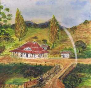
Painting, Lower Plenty Hotel c1940-1950, 1940-1950
Artists impression of the Lower Plenty Hotel mid-20th century. An original painting of the Lower Plenty Hotel.Mixed media on canvas board. Landscape with hotel in middle ground.Signed with initials "S.J." on front. On back: "From photo. Painted 1960-1970. LOWER PLENTY HOTEL c1940-1950. Sylvia Jones"lower plenty, lower plenty hotel, sylvia jones -
 Greensborough Historical Society
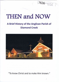
Booklet, Nillumbik Historical Society, Then and now: a brief history of the Anglican Parish of Diamond Creek, 22/10/2019
A history of the Anglican Parish of Diamond Creek, prepared for the Yarra Plenty Regional Library's "Diamond Valley History Tour 2019". The Diamond Creek parish includes St John's Diamond Creek, St Michael's Yarrambat and St Katherine's St Helena.Booklet, 8 pages, text and colour illus.diamond valley, yarra plenty regional library, anglican parish of diamond creek, st john's diamond creek, st katherine's st helena, st michael's yarrambat -
 Greensborough Historical Society
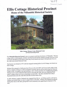
Document - Article and Leaflet, Nillumbik Historical Society, Ellis Cottage Historical Precinct, 22/10/2019
Article about Ellis Cottage Historical Precinct, home of Nillumbik Historical Society prepared by the Society for the Yarra Plenty Regional Library's "Diamond Valley History Tour 2019". Describes Ellis Cottage and the Ellis family who lived there. Includes a leaflet on the historical society.Article and leaflet, text and colour illus.diamond valley, yarra plenty regional library, nillumbik historical society, ellis cottage, william ellis -
![View of the Township of Mt. Blackwood / [by] Nicholas Caire, circa 1876](/media/collectors/550653872162f11fb04854aa/items/57830cfbd0cdd1176c424e00/item-media/57830d7ad0cdd1176c428423/item-fit-380x285.jpg) Kew Historical Society Inc
Kew Historical Society IncPhotograph, Anglo-Australasian Photographic Company, View of the Township of Mt. Blackwood, c. 1876
Nicholas Caire was born on Guernsey in the Channel Islands in 1837. He arrived in Adelaide with his parents in about 1860. In 1867, following photographic journeys in Gippsland, he opened a studio in Adelaide. From 1870 to 1876 he lived and worked in Talbot in Central Victoria. In 1876 he purchased T. F. Chuck's studios in the Royal Arcade Melbourne. In 1885, following the introduction of dry plate photography, he began a series of landscape series, which were commercially successful. As a photographer, he travelled extensively through Victoria, photographing places few of his contemporaries had previously seen. He died in 1918. Reference: Jack Cato, 'Caire, Nicholas John (1837–1918)', Australian Dictionary of Biography.An original, rare photograph from the series 'Views of Victoria: General Series' by the photographer, Nicholas Caire (1837-1918). The series of 60 photographs that comprise the series was issued c. 1876 and reinforced a neo-Romantic view of the Australian landscape to which a growing nationalist movement would respond. Nicholas Caire was active as a photographer in Australia from 1858 until his death in 1918. His vision of the Australian bush and pioneer life had a counterpart in the works of Henry Lawson and other nationalist poets, authors and painters.‘View of the Township of Mt. Blackwood’ : Views of Victoria (General Series) No.42 : Albumen silver photograph | Photo on card with Title and Description on reverse | Mounted 24 x 30 cm; Photo 12 x 17 cm.On Reverse: ‘The locality which this illustration represents was formerly known as the Blackwood Forest, and has been the scene of considerable mining activity. The shallow alluvial diggings of the early days have given place to the deep sinking in search of reefs. This scene is characteristic of the wild appearance which many of the inland townships of Victoria represent.’nicholas caire (1837-1918), blackwood (vic), mount blackwood, landscape photography - victoria -
 Greensborough Historical Society
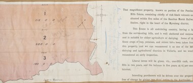
Application, Squatters, speculators and settlers: Plenty River Cultural heritage trail, 20/12/2011
This application is for the restoration and preservation of listed heritage sites along the Plenty River in Greensborough and surrounding area. Although the 2011 application was not successful there is much information about the Plenty River trail in this document.This document contains relevant information regarding the various sites along the Plenty River. 3 copies. 60 p., ill. (some col.). Copy 1 is in an A4 3 ring binder and plastic pockets (Location Greensborough Historical Society publications shelf), copy 2 is spiral bound (Location Plenty River Cultural heritage Trail file), copy 3 has loose pages (Location GHS file)Heritage Victoria application reference: 53149plenty river cultural heritage trail, dennis ward, anne paul, rotary club of greensborough, plenty historical society, plenty river -
![View of the Township of Ballan / [by] Nicholas Caire, circa 1876](/media/collectors/550653872162f11fb04854aa/items/578258d3d0cdd1176ce23812/item-media/57825939d0cdd1176ce27694/item-fit-380x285.jpg) Kew Historical Society Inc
Kew Historical Society IncPhotograph, Anglo-Australasian Photographic Company, View of the Township of Ballan, c. 1876
Nicholas Caire was born on Guernsey in the Channel Islands in 1837. He arrived in Adelaide with his parents in about 1860. In 1867, following photographic journeys in Gippsland, he opened a studio in Adelaide. From 1870 to 1876 he lived and worked in Talbot in Central Victoria. In 1876 he purchased T. F. Chuck's studios in the Royal Arcade Melbourne. In 1885, following the introduction of dry plate photography, he began a series of landscape series, which were commercially successful. As a photographer, he travelled extensively through Victoria, photographing places few of his contemporaries had previously seen. He died in 1918. Reference: Jack Cato, 'Caire, Nicholas John (1837–1918)', Australian Dictionary of Biography.An original, rare photograph from the series 'Views of Victoria: General Series' by the photographer, Nicholas Caire (1837-1918). The series of 60 photographs that comprise the series was issued c. 1876 and reinforced a neo-Romantic view of the Australian landscape to which a growing nationalist movement would respond. Nicholas Caire was active as a photographer in Australia from 1858 until his death in 1918. His vision of the Australian bush and pioneer life had a counterpart in the works of Henry Lawson and other nationalist poets, authors and painters.‘View of the Township of Ballan’.; Views of Victoria (General Series) No.35; Albumen silver photograph | Photo on card with Title and Description on reverse | Mounted 24 x 30 cm; Photo 12 x 17 cm.On Reverse: ‘The Township of Ballan is situated near the Bullarook Forest, and is distant about twenty miles from Ballarat. It is chiefly a small agricultural town, but it has become notable of late owing to its Mineral Springs, of which there are several in the neighbourhood. The most important one is owned by Messrs. Joske & Co., who supply the public with this delightful beverage.’ nicholas caire (1837-1918), ballan, bullarook forest, mineral water, ballan mineral springs, post and rail fence -
 Ringwood and District Historical Society
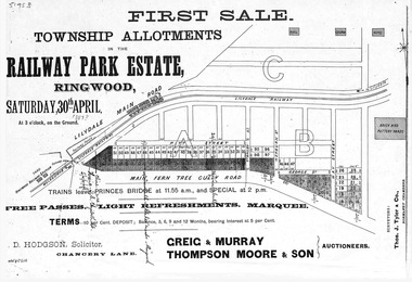
Flyer, Subdivision advertisement - Railway Park Estate, Ringwood, Victoria - circa 1887
Photocopy of advertisement for auction sale of township allotments in Railway Park Estate, Ringwood, on Saturday 30th April (1887?), with terms of sale and location map.Subdivision map includes Pitt Street and Main Ferntree Gully Road (later Bedford Road). (Agents) Greig & Murray, Thompson Moore & Son, Auctioneers. -
 Stawell Historical Society Inc
Map, Township of Stawell, County of Borung, 1958
Township of Stawell, County of Borungstawell -
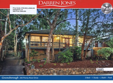
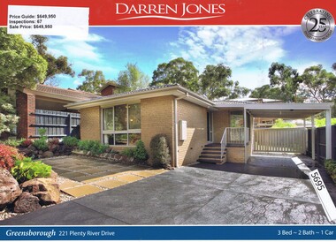 Greensborough Historical Society
Advertising Leaflet, Darren Jones, 221 Plenty River Drive Greensborough, 13/05/2017
221 Plenty River Drive Greensborough. Three bedroom house, sold for $649,950 in July 2017. Real estate advertising leaflet, 1 sheet, printed in colour both sides. plenty river drive greensborough -
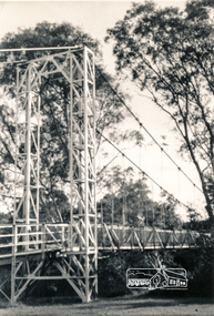
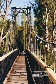 Eltham District Historical Society Inc
Photograph, Pedestrian suspension bridge over the Yarra River at Lower Plenty
Odyssey House drug rehabilitation centre in Bonds Road, Lower Plenty is a distinctive landmark, especially when viewed from across the Yarra at Templestowe. It was built in the 1950’s as a seminary for the Blessed Sacrament Fathers. Because of the poor and circuitous road access, a suspension footbridge was built across the river. As well as providing easy access for the priests residents of Templestowe could attend services at the seminary. The bridge is now part of the Yarra Trails system.Colour photograph of footbridge over Yarra River, part of the Ruffey Trail just off the Main Yarra Trail near the former seminary (now Odyssey House) Lower Plentybridges, yarra river, lower plenty, seminary, blessed sacrament fathers, odyssey house, bonds road -
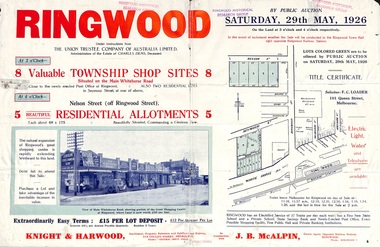 Ringwood and District Historical Society
Flyer, Township Shop Sites and Residential Allotments Sale By Public Auction, Ringwood, Victoria - 1926
Advertisement for eight township shop sites and five residential allotments for sale by Public Auction on the land in Ringwood on Saturday, 29th May, 1926, with location map, and summary of local features and services. Locality plan highlights sites for auction in Nelson Street, Seymour Street and Whitehorse Road. (Agents) Knight & Harwood, 315 Collins Street, Melbourne, Phones 10615, 10616 Central, in conjunction with J.B. McAlpin, Estate Agent, Opposite Railway Station, Ringwood, Phone Ringwood 7. -
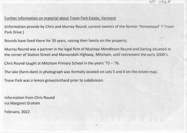 Whitehorse Historical Society Inc.
Document - Real estate notes, maps, flyers, Trove Park Estate, 1969, 2022
A history of the Trove Park Estate, Vermont from 1880's to 2022 is provided by notes, maps, pictures and auction flyers. The Estate was originally part of the Uplands Estate of 34 acres in the Mount Pleasant district.A history of the Trove Park Estate, Vermont from 1880's to 2022 is provided by notes, maps, pictures and auction flyers. The Estate was originally part of the Uplands Estate of 34 acres in the Mount Pleasant district.A history of the Trove Park Estate, Vermont from 1880's to 2022 is provided by notes, maps, pictures and auction flyers. The Estate was originally part of the Uplands Estate of 34 acres in the Mount Pleasant district.trove park drive estate vermont, mt pleasant, trove park, uplands vermont, bishop edward, round chris & murray, mulcahy mendelson & round, trove park drive vermont no 7 -
Port Melbourne Historical & Preservation Society
Map - "The Township of Sandridge", Public Lands Office, 1859
Photocopy 1859 map of township of Sandridgelocal government - municipal district of sandridge, frank callaghan -
 Bacchus Marsh & District Historical Society
Map, Pentland Hills Estate Land Sale 1904
The Pentland Hills Estate property shown in this auction plan was put up for sale in 1904. It was a deceased estate sale. The property had been owned by Peter Grant who died in 1899. Peter Grant had worked and farmed in the Myrniong area for many years and had also been a Councillor on the Bacchus Marsh Shire for a number of terms. A property sales report in the Express newspaper recorded that the land for sale comprised 500 acres of the old Pentland Hills Estate. It was subdivided into three lots, all of which were sold at good prices. Lot l, 212 acres was sold to Messrs Thomas and Robert Lidgett of Myrniong, at £11/15/ per acre, lot 2, 200 acres, to Mr David Robertson, of Bacchus Marsh, at £9 17/0 per acre, and lot 3, 38 acres, was sold to Mr James Norton, jun at £11 per acre. A single page paper map showing a portions of land available for sale from the Pentland Hills Estate near Bacchus Marsh.The name of the seller, Mrs Grant, can seen handwritten on this map and the buyers of the three portions for sale, Lidgett lot 1, Robertson lot 2 and Morton lot 3. Parts of the text are missing along the edges due to tearing or excessive trimming of the edges. The map is pasted into a bound volume containing 76 maps or plans in total. High resolution digital image stored on BMDHS computer network. Handwritten: Mrs Grant, Myrniong, Executrix in the deceased Estate of Mr. Peter Grant to sell by public auction.land sales, pentland hills maps, myrniong area land sales, pentland hills estate -
 Greensborough Historical Society
Leaflet, Coventry and Co Real Estate, Is winter the new spring?, 2015_
Advertisement for Coventry and Co Real Estate 129 Main Street Greensborough. Jon Challands joined Coventry & Co.as real estate agent, in December 2014. This advertising appeared during the winter 2015 season.Col. leaflet soliciting real estate vendorscoventry and co real estate -
 Greensborough Historical Society
Advertising Leaflet, Darren Jones, 20 Plenty River Drive Greensborough, 16/12/2017
20 Plenty River Drive Greensborough. Three bedroom home, sold for $830,000 in December 2017. Previous sales: January 1980, $15,250.Real estate advertising leaflet, 1 sheet, printed in colour both sides. plenty river drive greensborough -
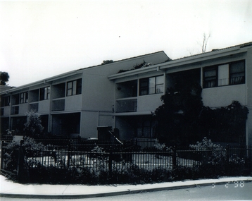 Broadmeadows Historical Society & Museum
Photograph, Banksia Gardens Housing Estate, Broadmeadows 1998, 3 February 1998
This photograph from 1998 captures the public housing at Banksia Gardens Housing Estate in Broadmeadows. The image provides a valuable historical record of the estate's development and the living conditions during that period. Banksia Gardens was designed to offer accessible and inclusive housing, reflecting the broader social and economic context of the time. The estate served as a vital community hub, fostering social connections and providing support to its residents.This photograph of the public housing at Banksia Gardens Housing Estate in Broadmeadows, taken in 1998, holds significant historical value. It captures the essence of the estate's development and the living conditions of the time. Banksia Gardens was designed to provide accessible and inclusive housing, reflecting the social and economic priorities of the late 1990s. The estate served as a crucial community hub, fostering social connections and offering essential support to its residents. This image stands as a testament to the efforts made to create a supportive and cohesive community environment, highlighting the importance of public housing in enhancing the quality of life for its inhabitants.Black and white photograph on glossy paper.Banksia Gardens Housing Estate/Broadmeadows 1998banksia gardens, broadmeadows, 1998 -
 Eltham District Historical Society Inc
Photograph, Pedestrian suspension bridge over the Yarra River at Lower Plenty
Odyssey House drug rehabilitation centre in Bonds Road, Lower Plenty is a distinctive landmark, especially when viewed from across the Yarra at Templestowe. It was built in the 1950’s as a seminary for the Blessed Sacrament Fathers. Because of the poor and circuitous road access, a suspension footbridge was built across the river. As well as providing easy access for the priests residents of Templestowe could attend services at the seminary. The bridge is now part of the Yarra Trails system.Two black and white photographs of footbridge over Yarra River, part of the Ruffey Trail just off the Main Yarra Trail near the former seminary (now Odyssey House) Lower Plentybridges, yarra river, odyssey house, bonds road, lower plenty, seminary, blessed sacrament fathers -
 Ringwood and District Historical Society
Map, Department of Mines, Plan of area applied for under the mining leases regulations in the township of Ringwood between Maroondah Highway and Mt. Dandenong Road. Mining District of Castlemaine, County of Mornington, Parish of Ringwood T Area 58(A) 2 (R)15(P) Acres, Roods, Perches. 1934, 20-Feb-34
Map of the township of Ringwood with subdivisions between Maroondah Highway and Mt. Dandenong Road. the area applied for on lease No.8210 by E.G.Browne.Mining District of Castlemaine, County of Mornington, Parish of Ringwood T Area 58(A) 2 (R)15(P) Acres, Roods, Perches.Buff coloured sheet foolscap with black printing showing map of the township of Ringwood between Maroondah Highway and Mt. Dandenong Road. Mining District of Castlemaine, County of Mornington, Parish of Ringwood T Area 58(A) 2 (R)15(P) Acres, Roods, Perches +Additional Keywords: Browne E.G. -
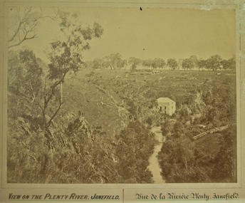 City of Whittlesea
Photograph (item) - Photographs - Landscapes, View on the Plenty River, Janefield
View on the Plenty River, Janefield / Vue de la Riviere Plenty - Janefield -
Whitehorse Historical Society Inc.
Document, Mitcham Township 1914 - 1917, n.d
Hand drawn map of Mitcham township c1914.Hand drawn map of Mitcham township c1914.Hand drawn map of Mitcham township c1914.boxshall, hilda, mitcham -
Stawell Historical Society Inc
Map, Township of Moyston, Parish of Moyston, County of Borung, 1956
Township of Moyston, Parish of Moyston, County of Borungstawell -
Stawell Historical Society Inc
Map, The Township of Elmhurst, Parish of Glenpatrick, Wimmera District
The Township of Elmhurst, Parish of Glenpatrick, Wimmera Districtstawell -
Stawell Historical Society Inc
Map, Department of Lands & Survey J. Noone, Township of Heatherlie. Parish of Baroka. County of Borung 1888, 1888
Stawell & Grampians Freestone Quarry Company Railway Reserve. Cross & masons Quarry Site. Mamnager'sHouse, Stead's boarding House Stawell and Grampians railwaySurveyed Township Showing Quarry and railway Reservephoto Lithographed at the Department of lands and Survey Melbourne By J Noone 15.6.88railway quarry -
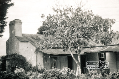 Eltham District Historical Society Inc
Photograph, House, 'Rosehill', Lower Plenty, 1968, 1968
Three black and white photographs of views of 'Rosehill' at Lower Plenty, 1968rosehill, bonds road, lower plenty, houses, henry stooke -
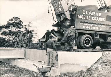 Eltham District Historical Society Inc
Photograph, Construction of Lower Plenty Bridge, Main Road, c.August 1966, 1966
Black and white photograph of construction of northern Lower Plenty Bridge 1969bridges, bridge construction, main road, lower plenty, plenty river, cranes -
Whitehorse Historical Society Inc.
Map, Gill's Springfield Road Estate, 1950?
Plan of subdivision for Gill's Springfield Road Estate, former orchard, 16 lots.Plan of subdivision for Gill's Springfield Road Estate, former orchard, 16 lots. Reprinted by Real Estate Agent, Spencer Jackson.Plan of subdivision for Gill's Springfield Road Estate, former orchard, 16 lots. land subdivision, norway avenue, blackburn, springfield road, blackburn, beverley crescent, blackburn, kevin avenue, blackburn, kerr street, blackburn, bordeaux avenue, blackburn, gill's estate, orchards, spencer jackson -
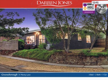 Greensborough Historical Society
Advertising Leaflet, 31 Plenty Lane Greensborough, 16/06/2018
31 Plenty Lane Greensborough. 3 bedroom home, on 380 sqm, auctioned 16 June 2018, P.I. $660,000 vendor bid, sold July 2018 for $610,000Real estate advertising leaflet, 2 sheets, 1 printed in colour both sidesplenty lane greensborough -
 City of Kingston
Pamphlet - Colour, Stillwell and Co, The Hill Estate, Highett, 1917
Sales plan for land in the suburb of Highett, bounded by Point Nepean Road and including Sandford Street, Turner Road, Alfred Street and Peace Street.The developing urban area of Highett within the City of Kingston. This land sale pamphlet illustrates the subdivision of land within the municipality and the changing demographic of the district as new houses are constructed close to infrastructure.Colour pamphlet advertising for sale at auction The Hill Estate, Highett. Incorporates a map of the estate bordered by Point Nepean Road and including Sandford Street, Turner Road, Alfred Street and Peace Street.Handwritten in grey pencil on subdivision map next to subdivisions 91, 92, 93, 106, 107 and 108: x Handwritten in grey pencil on back cover: The / Hill Estate / Highettland sales, estate, highett -
Stawell Historical Society Inc
Map, Township of Crowlands, Parish of Crowlands, County of Kara Kara, 1857
Township of Crowlands, Parish of Crowlands, County of Kara Kara stawell