Showing 6777 items matching "river"
-
 Ballarat Heritage Services
digital photographs, L.J. Gervasoni, Yarra River Melbourne Docklands wharves and markers, 2015
Digital Imagesyarra river melbourne docklands, yarra river, dock, docklands, shipping, port, channel, water, ship, wharf, channel marker -
 Ballarat Heritage Services
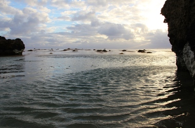
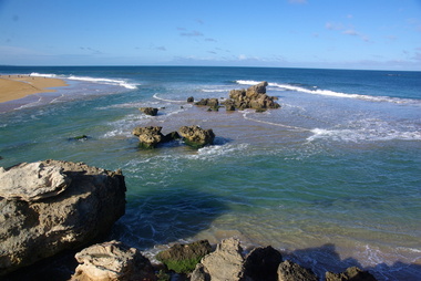
Digital photographs, L.J. Gervasoni, Hopkins River Mouth blocked, c2010 - 2017
hopkins river, mouth, point ritchie, bluehole, warrnambool, coast, coastal, beach, seascape, blocked -
 Ballarat Heritage Services
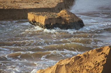
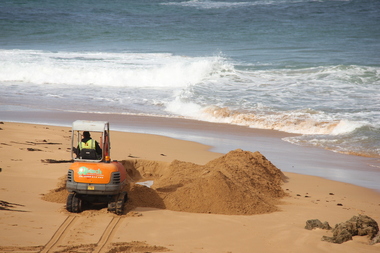
Digital photographs, L.J. Gervasoni, Hopkins River Mouth blocked - artificial channel - sand falling in, c2010 - 2017
hopkins river, mouth, point ritchie, bluehole, warrnambool, coast, coastal, beach, seascape, blocked, digger, opening mouth, mechanical opening -
 Ballarat Heritage Services
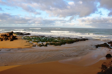
Digital photographs, L.J. Gervasoni, Hopkins River Mouth reef exposed after flood, c2010 - 2017
hopkins river, mouth, point ritchie, bluehole, warrnambool, coast, coastal, beach, seascape, flood, post flood, reef, exposed, geology, coastal geomorphology -
 Ballarat Heritage Services
Digital photographs, L.J. Gervasoni, Hopkins River Mouth in flood - waters receeding, c2010 - 2017
hopkins river, mouth, point ritchie, bluehole, warrnambool, coast, coastal, beach, seascape, flood, post flood, geology, coastal geomorphology, waters receeding -
 Ballarat Heritage Services
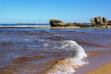
Digital photographs, L.J. Gervasoni, Hopkins River Mouth after the flood, c2010 - 2017
hopkins river, mouth, point ritchie, bluehole, warrnambool, coast, coastal, beach, seascape, flood, post flood, geology, coastal geomorphology, waters receeding -
 Ballarat Heritage Services
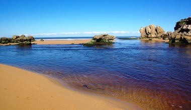
Digital photographs, L.J. Gervasoni, Hopkins River Mouth - double channel post flood, c2010 - 2017
hopkins river, mouth, point ritchie, bluehole, warrnambool, coast, coastal, beach, seascape, coastal geomorphology -
 Ballarat Heritage Services
Digital photographs, L.J. Gervasoni, Hopkins River Mouth - blocked - mechanical digger, c2010 - 2017
hopkins river, mouth, point ritchie, bluehole, warrnambool, coast, coastal, beach, seascape, coastal geomorphology -
 Marysville & District Historical Society
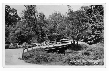
Postcard (Item) - Black and white postcard, Valentine Publishing Co. Pty. Ltd, BRIDGE OVER STEAVENSON RIVER, MARYSVILLE. V.34, 1923-1963
A black and white photograph of a bridge over the Steavenson River in Marysville in Victoria.A black and white photograph of a bridge over the Steavenson River in Marysville in Victoria. The Steavenson River is named after the Victorian Assistant Commissioner of Roads and Bridges, John Steavenson who arrived in Victoria in the early 1860s. This postcard was produced by Valentine Publishing Co Pty. Ltd. as a souvenir of Marysville.VALENTINE'S POST CARD A GENUINE PHOTOGRAPH 1940marysville, victoria, steavenson river, valentine publishing co, postcard, souvenir, john steavenson -
 Stawell Historical Society Inc
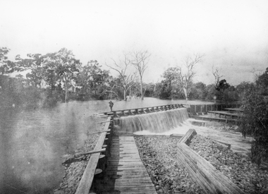
Photograph, Wimmera River Weir at Glenorchy
Wimmera River Weir Glenorchy. Part of Wimmera Mallee Irrigation SystemBlack & white photograph of a weir across a river. Construction of weir is log & wood with a person walking along the weir. Trees in the background.Reproduction Rights Reserved Copied by State Library of Victoriawater -
 Kew Historical Society Inc
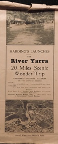
Flyer, Melbourne Ferries Pty Ltd, River Yarra: 20 Miles Scenic Wonder Trip
Bifold brochure including route map of the full 44 mile 'Wonder Trip' on pages 2 & 3. Photos used include an 'Aerial view over Dight's Falls', two ferries, and a 'Scene near Dight's Falls'.Flyer for Harding’s Launches on the River Yarra: 20 miles scenic wonder trip. Aerial view over Dight’s Falls on front. non-fictionBifold brochure including route map of the full 44 mile 'Wonder Trip' on pages 2 & 3. Photos used include an 'Aerial view over Dight's Falls', two ferries, and a 'Scene near Dight's Falls'.river yarra, melbourne ferries pty ltd, yarra river -- tourism, harding's cruises, christian-washfold collection -
 Hume City Civic Collection
Book, Saltwater River History Trails
This book which was printed in 1984 gives not only the geology of the area but also the history of the various areas that Jacksons Creek and the Saltwater River now known as the Maribyrnong River pass through. There are many drawings and photos accompanying the information relating to the various areas and buildings researched in this book. From Sunbury to Williamstown some of the names and places mentioned include John Aitken, George Evans, William J.T. Clarke, Ben Eadie, Rupertswood, Goonawarra Vineyard, Organ Pipes, Glenara, Walter Clark, Keilor, Overnewton, Avondale Heights, Solomons ford, Riverview Tea Gardens, Anglers Hotel, Aberfeldie Park, Humes Pipe Works, Powder Magazine, Maribyrnong, Munitions factories, Footscray Park, Flemington, Footscray, Yarraville, Newport, Williamstown, Commonwealth reserve, the blue stone lighthouse. A small cream/olive green colour covered printed book of 74 pages. The front cover shows part of a pen and wash drawing of a homestead. It has the name of the book and the author Hugh Anderson printed at the top of the cover and Sunbury to the Sea printed at the bottom. There are many drawings and photos included in the book.SALTWATER RIVER/HISTORY TRAILS/HUGH ANDERSON/Sunbury to the Seasaltwater river, maribyrnong river, jacksons creek, anderson hugh, sunbury, keilor, organ pipes national park, solomons ford, riverview tea gardens, humes pipe works, powder magazine, footscray, yarraville, newport, williamstown -
 Ballarat Heritage Services
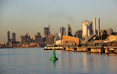
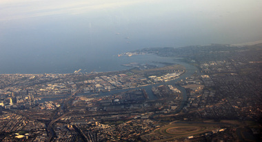
Photograph, L.J. Gervasoni, Mouth of the Yarra River from the air, 2016
Digital Image showing an aerial view of the mouth of the Yarra River from the airaerial, melbourne, mouth, yarra, river, port phillip bay, flemington, docklands, bolte bridge, west gate bridge -
 Orbost & District Historical Society
plan, before 1948
Drainage infrastructure was developed and maintained in this region by the Snowy River Improvement Trust. The Trust was administered by a local committee and its activities funded by a local rate charged on the farmers and land owners in the Trust’s designated district. The level of the rate charged by the Trust was designed to be proportionate to the benefit derived from the works undertaken. Financial assistance was provided by the State Government from time to time for specific projects such as post flood repairs but not for new capital works. The Trust undertook new drainage and river management works including tree planting, rock beach construction and servicing of the drains and flood gates. The Trust also provided a personal flood warning service to the farmers in its district. The Trust ceased to operate in 1997 with the advent of the East Gippsland Catchment Management Authority. The infrastructure developed by the Trust continues to provide a service to the farmers in the region. (ref. 4 East Gippsland CMA Submission to Inquiry into Flood Mitigation Infrastructure in Victoria) This plan is significant as a historical document. The Snowy River Improvement Trust was vital to the Orbost district because of its ability to apply local knowledge and to engage the local farming community.A large plan of divisions of land for the purpose of levying the Snowy River Improvement District - Bete Bolong, Orbost, Waygara, Newmerella and Orbost East. The properties are coloured according to levy amount. The scale is 1" - 20 chains. snowy-river-improvement-trust -
 Charlton Golden Grains Museum Inc
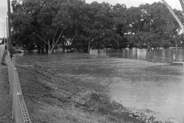
Photograph, Cameron, Ian, 1973 flooded Avoca River, Feb 19873
1973 flooded Avoca River. Viewed from west side of Paterson Bridge behind the shire office.B/W photograph of 1973 flooded Avoca River. View West side of Paterson Bridge behind Shire Officeflood, avoca river, charlton -
 Orbost & District Historical Society
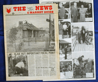
newspaper clippings, April, May 1987
The Slab Hut (Orbost Visitor Information Centre) was opened on March 28, 1987. It was officially opened by Dr D. Caughey, the governor of Victoria. The Orbost Visitor Information Centre is situated in Forest Park on Nicholson Street. The centre is housed in the historic Slab Hut. The hut was an original family dwelling built in 1872, on a site approximately three kilometres upstream from the junction of the Buchan and Snowy Rivers. The Hut was removed from its original site around 1970, and stored until 1984 when the Shire Council approved the current site. It was restored and brought to life as a Tourist Information Centre in 1987.The Slab Hut is an icon of Orbost. These newspaper articles are contemporary records of the opening of this building.A selection of articles from The News and the Snowy River Mail. All relate to the opening of the Slab Hut, the Orbost Visitor Information Centre. They are photographs, information and the history of the Slab Hut.slab-hut-orbost newspaper-snowy-river-mail -
 Kiewa Valley Historical Society
Black and white photograph of Surveyor's Camp, 1938, Kiewa River and surveyor's Camp 25/8/38, 25/08/1938
Surveying under the prevailing conditions at this time was an arduous and demanding task. There were no roads beyond Tawonga and access was by bridle tracks, on foot or horseback. This camp was to provide accommodation to those men who were surveying the road from South Tawonga to the Bogong High Plains which was commenced in April, 1938. The actual work was undertaken by the Country Roads Board, on behalf of the State Electricity Commission, using three Caterpillar diesel crawler tractors equipped with Kay Bruneriei (Brunner) lhydraulically operated trailbuilders (angle dozers)This photograph shows the primitive living conditions that were endured by those carrying out the initial field investigations and surveys for the Kiewa Hydro Electric Scheme. It is possibly one of the few photographs in existence of this camp and of the very rustic timber foot bridge across the West Kiewa river. It has been taken from approx. 100m up Simmonds Creek Road. A black and white photograph showing a small, timber foot bridge across the West Kiewa River. There is a man standing on the bridge and two small huts on the far side of the river, against a backdrop of Mt. Beauty and Mt. Bogong.At the top of the photograph, handwritten in black ink is the inscription "Kiewa River and Surveyor's Camp 25/8/38". The number 4 is stamped towards the right upper corner. On the back, in a circle, about 1.3cm in diameter, are the words "Kodak Print". The word "Velox" is faintly discernible on the back as well.surveyor, tawonga, west kiewa river, bridge, camp, secv -
 Australian Commando Association - Victoria
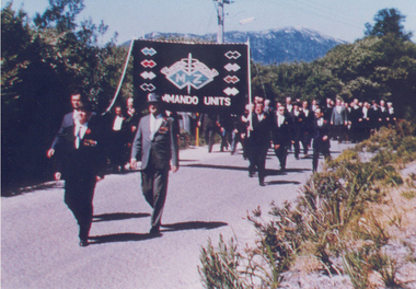
Photograph, Inaugural march of M& Z Commando Association members at The Australian Commando Memorial at Tidal River 16 November 1964
The WW2 Commando memorial cairn was unveiled at Tidal River on 15 November 1964 by the Lieutenant Governor of Victoria Lieutenant General Sir Edmund Herring. Former WW2 Commandos march under their Association banner to the cairn for the dedication ceremony.This was the first dedication of a significant WW2 Commando memorial. The Victorian Governor, Lieutenant General Sir Edmund Herring, unveiled the Commemorative Cairn that has become the de facto national Commando memorial.Rectangular colour glossy print photograph of former WW2 Commandos marching at Tidal River.From Don Bergmanww2, world war ii, australian commandos, independent companies, australian commando association, tidal river, wilsons promontory national park -
 Marysville & District Historical Society
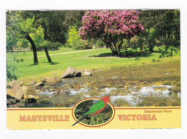
Postcard (item) - Colour postcard, Neil Cutts, Marysville Victoria-Steavenson River, Pre 2009
A postcard in a series produced by the Rose Stereograph Company in Victoria, Australia as a souvenir of Marysville.A colour photograph of the Steavenson River which flows through Marysville in Victoria. The Rose Series postcard No. 3527.POST CARD The "Rose" Series/ De Luxe Proudly Printed in/ Australia Since 1880 AFFIX/ STAMP/ HERE/ Rose Series/ Post Card No./ 3527 ADDRESS/ POSTCODE Steavenson River/ MARYSVILLE, VICTORIA, AUSTRALIA/ Photo Neil Cutts Copyright Rose Stereograph Co., Glen Waverley, Victoria (03) 9560 7772marysville, victoria, steavenson river, postcard, souvenir, rose stereograph co, 3527 -
 Sunbury Family History and Heritage Society Inc.
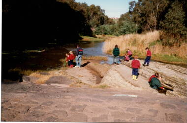
Photograph, River studies
Students from Bulla Primary school were taken to the nearby Deep Creek to study some of the river life inn the local water course.Bulla township is situated in the Deep Creek valley and was an ideal place to take students to study river life close to their school.A coloured photograph of eight children with two adults standing on a rocky outcrop beside a river and looking at the riverlife in the water.rivers, deep creek, river studies, bulla, bulla primary school -
 Kew Historical Society Inc
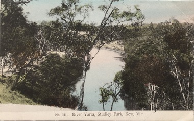
Postcard, The VSM.Series, No.351. River Yarra, Studley Park, Kew, Vic, c.1905
This is a colour postcard of the River Yarra at Studley Park, circa 1905. The postcard, which has handwritten notes on the reverse. It was printed in Prussia as part of the Victoria Stamp Market (VSM) Series. Coloured postcard of the Yarra River looking north from Galatea Point, near the Johnson Street Bridge.Donated by Miss B. Challen. ?Taken from bend above Galatea Point, looking north. Identified by Darcy Dugan, Yarra Bend Parks.river yarra, victoria stamp market (vsm) series, postcards -
 Wodonga & District Historical Society Inc
Album - Ringer's River by Des Martin - Plate 8 - O'Day meets Grapeshot
Pushing his mob along the back boundary of Barmagulla Station, whose owner, Edmund Montieth, a wealthy, well educated, and forward thinking gentleman accepted as a leader of the N.S.W. pastoralists "just across the border", O'Day hears the shrill whinny of a stallion. On riding over to investigate he finds that, in the practise of the day, a superb thoroughbred horse has been turned out on the river flats to acclimatise. Later he learns that this is Grapeshot, a classic winner just imported from England.The albums and images are significant because they document literature written by a prominent member of the Wodonga community. The presentation of this precis was supported by several significant district families and individuals.Ringer's River Album Coloured photo Plate 8des martin, many a mile, ringer's river, northeast victoria stories -
 Orbost & District Historical Society
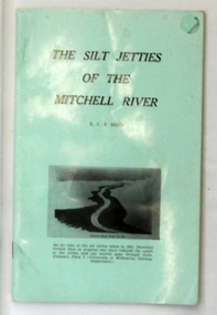
book, James Yeates & Sons (Printing) Pty Ltd, The Silk Jetties of the Mitchell river, 1972
This booklet was the first of a series of scientific and historical studies of Gippsland to be published by the Bairnsdale Advertiser. The author, Eric Charles Frederick Bird was Principal Fellow, Department of Geography, University of Melbourne, Australia. The Mitchell River silt jetties are an unusually long, thin landform located in the Gippsland Lakes region. They have been formed over millions of years by sediment deposition from the Mitchell River during periods of low water flow and subsequent wash-through during periods of high water flow. The long narrow banks of silt extend more than eight kilometres east into Lake King. This item is a useful reference for the silt jetties of the Mitchell River.A 32 pp book with alight green cover. The title is in black print, " The Silk Jetties of the Mitchell River" and underneath the title there is a b/w photograph of the Mitchell River and silt jetties taken from above in 1931. It was written by E. C. F. Bird.silt-jetties mitchell-river paynesville bird-e.c.f. -
 Otway Districts Historical Society
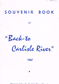
Book, "Back to Carlisle River", 1967
The settlement and settlers of Carlisle River, first known as "New Church Run" in 1861 until its name change in 1890-91.Souvenir bbok of "Back to Carlisle River", 1967. Colac (Vic); Herald Print; 1967. 25 p.; illus. Soft cover.Under Hotel, an insertion entitled "The Carlisle Hotel" containing the names of the licencees until its surrender on 31 December 1928.carlisle river; new chuch run; butter; history; sport; -
 Stawell Historical Society Inc
Photograph, Dunmunkle Creek where it originally connected to Wimmera River 2017 -- Coloured
Colour Photo of Dunmunkle Creek originally connected to Wimmera River at this point. Just before the Glenorchy Weir. 2017Colour photograph of what looks to be a dry creek bed. Timber on creek bank. Dunmunkle Creek originally connected to Wimmera River at this point. Just before the Glenorchy Weir (Photo taken 2017) water -
 Orbost & District Historical Society
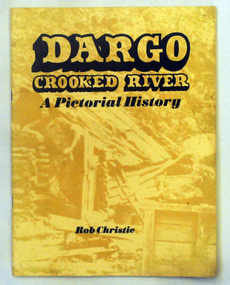
book, Enterprise Press Pty Ltd, Dargo Crooked River, C 1994-1997
This is a pictorial history of the Crooked River district.This is a useful reference tool on the history of gold mining in the Dargo area.A thin 56 pp paperback book titled,"Dargo Crooked River a Pictorial History". On the yellow front cover is a sepia photograph of a man standing outside a rough wooden hut. The title and author are printed in black text over this. The book contains Black / white photographs and the history of Dargo and Crooked River. The information is divided int decades. Inside there is a newspaper cutting of Victorian cattlemen on Junction Plain near Omeo.dargo-crooked-river gold-mining east-gippsland-history -
 Vision Australia
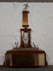
Photograph - Image, River Run Female Winner trophy
A race along the banks of the Yarra River (?) this trophy was awarded to the female winners from 1978-1987. A golden running figure sits atop a pedestal that rests on a bell located above two pedestals behind a golden laurel wreath. Two eagles, with wings outstretched as if just landing, are either side of the wreath and the inscription 'Rotary Club of Glenferrie - River Run - Female winner - Donated by Bob Bruner' is written on the plinth below them. On the base plinth are inscribed the names of the previous winners: 1978 Lynne Williams 1979 Lynne Williams 1980 Lynne Williams 1981 Dorothy Browne 1982 Dorothy Browne 1983 Michelle Baumgarten 1984 Laura Dess 1985 Mary Edwards 1986 Julie McKie 1987 Julie McKieGold running figure atop two levels of columns with a wreath and two eagles at the base, whereupon names are inscribedRotary Club of Glenferrie River Run Female Winner Donated by Bob Brunerassociation for the blind, awards -
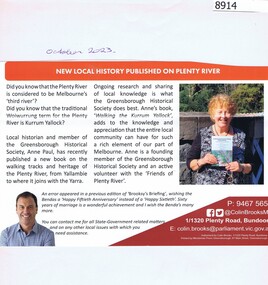 Greensborough Historical Society
Article - Newsletter Clipping, Colin Brooks, New Local History published on Plenty River, 2023
Article about Anne Paul's book, "Walking the Kurrum Yallock" regarding the walking tracks and heritage of the Plenty River, from Brooksy's BriefingPrinted article about book written by Anne Paul regarding th walking track and heritage of the Plenty River from Brooksy's Briefingplenty river, anne paul, greensborough historical society, colin brooks -
 Wodonga & District Historical Society Inc
Album - Ringer's River by Des Martin - Plate 32 - The shooting of Nugent
Advised of the tragedy by one of the stockmen Ellen O'Hara drives the gig towards Overton, but meets Klinberg who tells her the police have found a body near Nugent's place. Ellen gets there as Nugent is pulling Keiran's body from the river. Shock grief, and old bitternesses unhinge her mind. Seizing Trooper Ryan's pistol from on top of his clothes she shoots Nugent dead, and bolts up a rough back track towards her home with the police in pursuit. Her pony falls while belting along a narrow, dangerous piece of the track, and the gig goes over a cliff. Ellen is killed.The album and images are significant because they document literature written by a prominent member of the Wodonga community. The presentation of this precis was supported by several significant district families and individuals.Ringer's River Album Coloured photo Plate 32des martin, many a mile, ringer's river, northeast victoria stories -
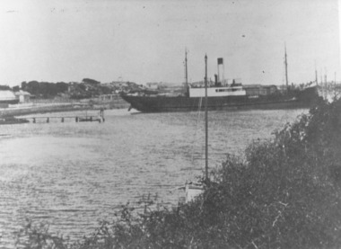 Port Fairy Historical Society Museum and Archives
Photograph
This shows the S.S.Wannon turning in the specially widened part of the river called the "turning basin" before slipping into her berth at the Belfast and Koroit Steam Navigation Company wharfBlack and white photograph of SS Wannon turning in the Moyne Rivership, boat, sea, moyne river, belfast and koroit steam navigation company, turning basin