Showing 217 items
matching rural landscape
-
 Wodonga & District Historical Society Inc
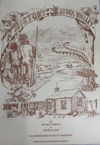
Book - A History of the Kiewa Valley, Esther Temple et al, 1989
... years to a more commercial rural/industrial landscaped valley ...This book briefly covers the period from the indigenous tribes who lived in the valley well before English settlers arrived. It documents the transformation of the area from a pristine valley environment to one that has been gradually over 200 years to a more commercial rural/industrial landscaped valley. The book details the first pioneers and their descendants, along with the changes to their environment.This book briefly covers the period from the indigenous tribes who lived in the valley well before English settlers arrived. It documents the transformation of the area from a pristine valley environment to one that has been gradually over 200 years to a more commercial rural/industrial landscaped valley. The book details the first pioneers and their descendants, along with the changes to their environment.kiewa river valley, pioneers victoria, kiewa valley social life and cusstoms -
 Wodonga & District Historical Society Inc
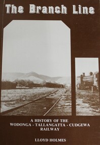
Book - The Branch Line : A history of the Wodonga - Tallangatta - Cudgewa Railway, Lloyd Holmes, 1985
This railway story concerns just one of the many branch lines that snaked across the landscape of Victoria. This book concentrates on the Wodonga - Tallangatta - Cudgewa line, a railway that took 32 years to complete from starting point to eventual terminus. The first section of the Wodonga to Tallangatta line opened in 1889 and was further extended in 1891. It was a vital community link until the passenger service closed in September 1961. The last regular goods train on the line ran on 21st April 1978. The north- east train line to Wodonga remained a significant factor in the development of Wodonga as a rural city in the 20th century.non-fictionThis railway story concerns just one of the many branch lines that snaked across the landscape of Victoria. This book concentrates on the Wodonga - Tallangatta - Cudgewa line, a railway that took 32 years to complete from starting point to eventual terminus. The first section of the Wodonga to Tallangatta line opened in 1889 and was further extended in 1891. It was a vital community link until the passenger service closed in September 1961. The last regular goods train on the line ran on 21st April 1978. The north- east train line to Wodonga remained a significant factor in the development of Wodonga as a rural city in the 20th century.railroads -- victoria, northeastern victoria, tallangatta, wodonga railways, cudgewa railroad -
 City of Kingston
Photograph - Black and white, 20 December 1945
This aerial photograph depicts the changing landscape of Cheltenham and Highett since WWII. Photographed in 1945, there is a mix of urban dwellings and industrial development and precedes the major transformation of Cheltenham with the development of the Southland shopping centre in the 1960s and expansion in the 1990s.A large part of Cheltenham was originally established as a rural market gardening community. The railway line and station brought urban development to the area and in the north, the Highett area was dominated by the Highett Gas Works. Cheltenham became a major destination for shopping in the 1960s with the opening of Southland.Aerial photograph taken in 1945 of Cheltenham and Highett within the City of Kingston. The image includes the Highett Reserve, (top right), the Methodist Children Homes (now Southland), Nepean Highway and Jamieson Street. Highett Gas Works is visible in the top left and the land now named William Fry Reserve at the intersection of Bay Road and Nepean Highway. A visible large parcel of land on the corner of Bay Road and Nepean Highway was developed in the 1990s as the west side addition to Southland. The densely vegetated area in the upper right sector of the image is now dense with housing. Tulip Grove, Heather Grove and Gilford Street are visible bottom left. This image is possibly from the collection of aerial photographs commissioned by the Department of Crown Lands and Survey and taken by Adastra Airways.Black ink: 57252 White lettering: VIC-10 57252 20.12.45 [lens information indecipherable] PROJ. No.5 MELB. METROP AREA Black pencil: 80highett, cheltenham, highett gas works, urbanisation -
 City of Kingston
Photograph - Black and white, 20 December 1945
This aerial photograph depicts the changing landscape of Cheltenham and Highett since WWII. Photographed in 1945, there is a mix of urban dwellings and industrial development and precedes the major transformation of Cheltenham with the development of the Southland shopping centre in the 1960s and expansion in the 1990s.A large part of Cheltenham was originally established as a rural market gardening community. The railway line and station brought urban development to the area and in the north, the Highett area was dominated by the Highett Gas Works. Cheltenham became a major destination for shopping in the 1960s with the opening of Southland.Aerial photograph taken in 1945 of Cheltenham and Highett within the City of Kingston. The image includes the Highett Reserve, (top right), the Methodist Children Homes (now Southland), Nepean Highway and Jamieson Street. Highett Gas Works is visible in the top left and the land now named William Fry Reserve at the intersection of Bay Road and Nepean Highway. A visible large parcel of land on the corner of Bay Road and Nepean Highway was developed in the 1990s as the west side addition to Southland. The densely vegetated area in the upper right sector of the image is now dense with housing. Tulip Grove, Heather Grove and Gilford Street are visible bottom left. This image is possibly from the collection of aerial photographs commissioned by the Department of Crown Lands and Survey and taken by Adastra Airways.Black type: Reverse lettering VIC-10 57252 20.12.45 [lens information indecipherable] PROJ. No.5 MELB. METROP AREA White lettering: Reverse writing 57252cheltenham, highett, highett gas works, urbanisation -
 City of Kingston
Photograph - Black and white, 5 January 1984
Cheltenham and Heatherton are suburbs in the City of Kingston that were originally established as a rural market gardening community. The market gardens, farms and paddocks have gradually been sub-divided into housing and industrial estates and associated infrastructure such as schools and shopping facilities. This aerial image covers a diverse section of the City of Kingston, taking in the suburbs of Cheltenham, Heatherton, Mentone and Parkdale. By 1984, the market gardens of the district have been replaced by housing and factories. The Nylex factory is visible and now closed. Mentone Bowl on the corner of Warrigal Road and Nepean Highway has now been replaced by high rise apartments, another feature of the changing landscape in the City of Kingston. The vacant land now occupied by the Moorabbin Airport Direct factory Outlet (DFO) is also depicted.Aerial photograph of Cheltenham, Heatherton, Mentone and Parkdale within the City of Kingston. The area depicted in the 1984 aerial view includes Centre Dandenong Road and Cheltenham East Primary School (top left), Kingston Heath Reserve (top right), intersection of Lower Dandenong Road, Warrigal Road, Balcombe Road and Nepean Highway (bottom left), Balmoral Drive/McSwain Street Parkdale (bottom right).White text: 3831-179 Lens information [indecipherable] RINGWOOD M/S 7922-3 RUN 16 [Clockface image] 5,300' ASL VIC DLS© 5-1-84cheltenham, heatherton, mentone, parkdale, market gardens, urbanisation -
 Buninyong & District Historical Society
Photograph - Black and white photograph, Mount Mercer circa 1920
View of landscape and farming land at Mt Mercer in the early part of the twentieth century Representation of the small outlying rural areas near Buninyong in the early twentieth centuryLandscape around Mt Mercer circa 1920mt mercer, landscape -
 Mission to Seafarers Victoria
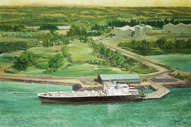
Painting - Painting, Acrylic, Ramon Honisett, Untitled, 1990-2000
Ramon (Ray) Francis Honisett (11.04.1931 - 30.08.2019), Fellow RMIT and medallist specialised in philatelic design, marine and military aircraft painting art and was active in the 1960s - 1990s. Ray Honisett used to live in Rye, in the Mornington Peninsula. According to Gavin Fry's book: The painting likely depicts the Lysaght Endeavour loading at Hastings. "The Lysaght Endeavour and its sister ship Lysaght Entreprise were built in Newcastle in 1973 specifically to serve the regional steel industry on the route Port Kembla - Westernport - Adelaide. Even after being lengthened by 17 metres, the two ships had remarkably short working lines, with both being broken up by 1988."Maritime artLarge framed unglazed landscape format painting predominantly green depicting in foreground a merchant vessel, a roll-on roll-off cargo ship moored at a single quayside on a river or river mouth. The middle ground shows a moderate solid jetty leading to large storage sheds at right. The background appears primarily rural with fields and hills in the distance. The location is probably Hastings Western Port in Victoria - notice the forklifts loading rolls of steel produced at the nearby steel rolling mill - the buildings in the distance. You can see the rolls of steel lined up on the hard stand to the right of the ship. The funnel colours suggest the Australian National Line. The frame incorporates a beige fabric slip with gilt edge the actual dark wood frame also with inset banded gilt edge. The back of the painting is covered with brown paper in places damaged. Hangs on a cotton cord threaded between two screw in eyelet hooks.at lower right corner single uc word in black paint : "HONISETT"tankers, marine painting, maritime art, ramon honisett, ray honisett, anl maritime art prize, acta maritime art prize, hastings, western port, victoria, steel, roll on roll off, forklift, mornington peninsula, artwork-paintings -
 Eltham District Historical Society Inc
Photograph - Digital Photograph, Alan King, Eltham Railway Trestle Bridge, 28 December 2007
Covered under National Trust of Australia (Victoria) State Significance and Heritage Overlay, Nillumbik Planning Scheme. Published: Nillumbik Now and Then / Marguerite Marshall 2008; photographs Alan King with Marguerite Marshall.; p103 The Eltham railway trestle bridge is the only one of its kind still regularly used in Melbourne’s metropolitan railway network. Opened in 1902, it is also one of Victoria’s very few timber rail bridges that still carries trains.1 The bridge is part of the railway line extension from Heidelberg - extended to Hurstbridge in 1912. This extension resulted in one of the greatest social changes experienced in Eltham Shire, as it considerably lessened its isolation attracting tourists, artists and suburban commuters particularly after World War Two.2 The bridge has been classified by the National Trust as historically, scientifically, aesthetically and socially significant at state level. But this has not always been recognised, and in 1977, locals fought to save it from destruction. The Victorian Railways proposed to replace the bridge with an earth embankment and large culverts to avoid maintenance problems and fire. This was rejected by the Eltham Council who protested that the bridge helped maintain the area’s rural character, historic link and beauty, as well as avoiding possible serious flooding on the flood plain if a culvert was blocked. The bridge stands as part of a National Trust classified landscape which includes the Alistair Knox Park, named after the local conservationist and architect who helped to make Eltham famous for its mud-brick houses. The landscape includes tall and spreading manna gums and candlebarks, and the historic Shillinglaw Cottage. Artist Walter Withers, one of the Heidelberg School of painters, painted the bridge early in the 20th century. The 38 span single-track railway bridge over creek and road has 34 timber-beam spans and four steel-joist spans, supported by four-pile timber piers and timber abutments. It has almost 200m of timber deck. All of the timbers have been replaced over the years, but the only change to the bridge’s character was the addition of pylons and wiring for electric trains in 1923. A petition for a railway to the shire was first made in 1883. A large deputation of local citizens to the Commissioner of Railways proposed a route passing through Alphington to midway between Greensborough and Eltham up the Diamond Creek valley towards Queenstown and Kinglake. As a result the Princes Bridge-Heidelberg Railway was opened in 1888. From 1888 locals demanded a railway extension. Kangaroo Ground farmers in particular, led by Shire Councillor and Member for Evelyn, Ewen Cameron, said it would assist local farmers and orchardists send their produce to the Melbourne market. In 1890, before the severe economic Depression, an extension of the line to Hurst’s Bridge (now Hurstbridge) was included in a new Railways Bill. The parliamentary delegations were regaled with a banquet at Hurst’s barn and entertained by the Diamond Creek Brass Band, but the extension was abandoned when the Depression struck in 1892-1893. The extension of the railway to Eltham, completed in 1902, was one of the few built in those hard times. That is why the Eltham timber-trestle railway bridge is a rare example of a broad-gauge rail bridge constructed between 1893 and 1910. At the opening, despite persistent drizzle, 300 children waving flags and banners were among the large crowd welcoming the first train, carrying official dignitaries, to Eltham. It had taken 24 years to bring the railway to Eltham. From then Eltham became a popular destination for outings. Mr Orford of Eltham recalled that after the railway came to Eltham ‘the craze for picnics on weekends and holidays began…. During the wattle season, wattle trains came to Eltham frequently. The visitors roamed the creek pulling great armfuls of wattle blossom to take back with them to Melbourne’.3 In 1926 the railway line was electrified as part of the metropolitan rail network. But the Victorian Railways decided not to complete the formerly planned Diamond Valley Railway to Queenstown (now St Andrews) and Kinglake.This collection of almost 130 photos about places and people within the Shire of Nillumbik, an urban and rural municipality in Melbourne's north, contributes to an understanding of the history of the Shire. Published in 2008 immediately prior to the Black Saturday bushfires of February 7, 2009, it documents sites that were impacted, and in some cases destroyed by the fires. It includes photographs taken especially for the publication, creating a unique time capsule representing the Shire in the early 21st century. It remains the most recent comprehenesive publication devoted to the Shire's history connecting local residents to the past. nillumbik now and then (marshall-king) collection, eltham railway trestle bridge, eltham trestle bridge -
 Eltham District Historical Society Inc
Photograph - Digital Photograph, Marguerite Marshall, 'Landscape', 60 Lavender Park Road, Eltham South, 24 June 2008
Built by artist and cartoonist Percy Leason in 1927 in what was then New Street but renamed Lavender Park Road in the late 1950s/early 1960s. Covered under Heritage Overlay, Nillumbik Planning Scheme. Published: Nillumbik Now and Then / Marguerite Marshall 2008; photographs Alan King with Marguerite Marshall.; p121 Said to be a genius, cartoonist Percy Leason’s career was at its peak when in 1925 to 1926 he built his home at New Street (now Lavender Park Road) Eltham. The Herald newspaper owner, Sir Keith Murdoch, had hired Leason for his newly acquired Melbourne Punch magazine at a salary of £1750, making him ‘one of the highest paid cartoonists in the world’.1 With this salary and financial help from Murdoch, Leason was able to build his lovely home in Eltham. At the crest of a sweeping drive, the home now two-storey in white brick with a gabled grey slate roof and dormer windows is flanked by an extension built by another owner in the 1980s. Leason lived in the home with his wife, Isabel and children, until 1937, when he left for the United States of America, where he lived until his death in 1959. The four-bedroom house and garden would have been well-suited to bringing up his family and to entertaining their friends in style. Large airy rooms have high ceilings with moulded plaster, timber floors and several are brightened with bay windows. Leason made friends with many of the artists and personalities who gravitated to Eltham. Around 1931 Justus Jörgensen, founder of the Montsalvat Artists’ Colony, helped Leason build his large studio at the back of the house. Another friend was journalist Mervyn Skipper, father of jeweller and sculptor Matcham, and artists Helen and Sonia. Leason’s teacher, artist Max Meldrum, also visited and rented accommodation in Eltham, opposite Wingrove Park. Punch folded in 1925, but Leason continued as cartoonist for Table Talk. In 1926 Leason began the cartoons of a mythical Australian town Wiregrass, which were inspired by Kaniva, his home town. The art gallery in Main Road Eltham was named Wiregrass in Leason’s honour. Leason completed 1000 drawings from 1919 to 1937, which author Garrie Hutchinson claimed, were technically unsurpassed and had regional and universal interest. Leason’s acute observations of country life stemmed from his childhood in Kaniva in Victoria’s western Wimmera, where he was born, the son of a selector, in 1889. Meldrum claimed that Leason could name every plant and the habits of every animal.2 Leason also painted 28 portraits of the last full-blooded aboriginals in Victoria at Lake Tyers in Gippsland, most of which are in a private collection. In Sydney Leason illustrated Henry Lawson’s Selected Poems and worked for The Bulletin. Leason had begun his career at 13 as an apprentice lithographic artist at Sands and MacDougall. He attended night classes at the National Gallery and the Victorian Artists Society. Leason first visited Eltham in 1910 to paint with fellow artist William ‘Jock’ Frater. They camped near Bible and Pitt Streets and along the Diamond Creek on the site of the present Eltham Retirement Centre. Despite his success as a cartoonist, Leason wanted to be recognised as a serious painter and for his anthropological work.3 He was also conservative and felt uncomfortable with the modern art scene in Melbourne.4 So he left for the United States of America to work as a painter. Ironically his time in New York saw the burgeoning of modern art, notably by artists such as Jackson Pollock. But Leason found his niche by running an art school, painting society portraits and illustrating books and magazines.This collection of almost 130 photos about places and people within the Shire of Nillumbik, an urban and rural municipality in Melbourne's north, contributes to an understanding of the history of the Shire. Published in 2008 immediately prior to the Black Saturday bushfires of February 7, 2009, it documents sites that were impacted, and in some cases destroyed by the fires. It includes photographs taken especially for the publication, creating a unique time capsule representing the Shire in the early 21st century. It remains the most recent comprehenesive publication devoted to the Shire's history connecting local residents to the past. nillumbik now and then (marshall-king) collection, landscape, lavender park road, percy leason, new street -
 Eltham District Historical Society Inc
Photograph - Digital Photograph, Marguerite Marshall, Former home of Professor William MacMahon Ball, York Street, Eltham, 24 May 2007
Situated at the eastern end of York Street, Eltham, 'Shinrone', the former home of Professor William (Mac) MacMahon Ball was one of the first in the Shire of Eltham to incorporate mud-brick. Professor MacMahon Ball, a political scientist, writer, broadcaster and diplomat and family moved to York Street, Eltham in 1945 into a timber cottage built around the 1890s and in poor repair. Mac asked Alistair Knox to renovate the home and he expanded the living area and added verandahs. In 1948 Montsalvat artist and sculptor Sonia Skipper supervised the building of most of the mud-brick studio. Neighbour Gordon Ford made the mud-bricks. Mac also asked John Harcourt, who had worked with him as a journalist in shortwave broadcasting, to build a pise (rammed earth) and stone addition to the largely timber house. Harcourt built two bedrooms - including an attic bedroom - a balcony with a shower and toilet, a nd a fireplace and chimney of local stone. Published: Nillumbik Now and Then / Marguerite Marshall 2008; photographs Alan King with Marguerite Marshall.; p141 At the eastern tip of York Street, Eltham, stands Shinrone, the former home of one of Australia’s intellectual leaders. Professor William Macmahon Ball, was one of the first to bring Asia as a foreign policy issue to the Australian public.1 He was a political scientist, writer, broadcaster and diplomat. The house was one of the first in Eltham Shire to incorporate mud-brick,2 because of the acute shortage of building materials after World War Two. Its novice builders later become leaders in Eltham’s built and garden design. Mac (as he was usually called), who was the son of a Church of England minister, was born in Casterton, Victoria in 1901 and died in 1986. In 1945 he helped establish the United Nations, as political consultant to the Australian Delegation at the San Francisco Conference.3 Then in 1946 Mac was appointed British Commonwealth Representative on the Allied Council for Japan, which is recorded in detail in his diary.4 In 1948 Mac led an Australian Government Goodwill Mission to South East Asia. However, Mac was perhaps most successful as an academic and public speaker.5 He was a commentator on the Australian Broadcasting Commission, from the early 1930s to the early 1960s. He was also Controller of the Short-Wave Broadcasting Unit during World War Two, which later became Radio Australia. From 1923 he taught at The University of Melbourne, then became foundation Professor of Political Science in 1949 and was Chair until his retirement in 1968.6 In 1942, as the government expected a Japanese invasion, Mac’s wife Katrine and their only child Jenny, moved from Kew to Eltham as temporary evacuees. However Mac and Katrine lived in Eltham for almost the rest of their lives. After staying with friends, they rented a house in Reynolds Road, where, as it was wartime, they needed to keep horses for transport and a cow and poultry for milk and eggs. In 1945 the family moved to the house at York Street, which was then a timber cottage, built around the 1890s and in poor repair. The underground well, cellar and part of the garden are all that remain of what stood on the original 18 acre (7.3ha) allotment. Thanks largely to Katrine’s hard work, the house was gradually renovated and extended. The long rambling house was partially built by several young neighbours, who were inspired by the cheap mud-brick and stone building style of Montsalvat, the Eltham artists’ colony. Mac asked Alistair Knox to renovate Shinrone, named after an Irish village near Katrine’s family home. Knox later popularised the mud-brick style of house construction, for which Eltham became known. He expanded the living area and added verandas. In 1948 Montsalvat artist and sculptor Sonia Skipper supervised the building of most of the mud-brick studio. Another neighbour, Gordon Ford, who was to have a major influence on the Australian garden style, made the mud-bricks. Mac also asked John Harcourt, who had worked with him as a journalist in short-wave broadcasting, to build a pisé (rammed earth) and stone addition to the largely timber house. Harcourt built two bedrooms – including an attic bedroom – a balcony with a shower and toilet, and a fireplace and chimney of local sandstone. With pioneering work naturally came mistakes, including one particularly dramatic incident when Harcourt was building walls with unsupported sections. Jenny Ellis, Mac’s daughter, remembers being awakened from sleep by a thundering shudder. The wall of her room had fallen down – fortunately away from her! In 1950 artist Peter Glass – another neighbour and later landscape designer – built Katrine a mud-brick pottery. As a result, the house features at one end Harcourt’s characteristic steep gable roof, while at the other the flatter construction characteristic of Knox. Mac referred to the home as the Eltham ‘experimental building site’.7 Surprisingly, the combination works, perhaps partly because it has the warm inviting feel of timber, mud-brick and stone.This collection of almost 130 photos about places and people within the Shire of Nillumbik, an urban and rural municipality in Melbourne's north, contributes to an understanding of the history of the Shire. Published in 2008 immediately prior to the Black Saturday bushfires of February 7, 2009, it documents sites that were impacted, and in some cases destroyed by the fires. It includes photographs taken especially for the publication, creating a unique time capsule representing the Shire in the early 21st century. It remains the most recent comprehenesive publication devoted to the Shire's history connecting local residents to the past. nillumbik now and then (marshall-king) collection, eltham, alistair knox, gordon ford, john harcourt, mudbrick construction, pise construction, professor macmahon ball, shinrone, sonia skipper, york street -
 Eltham District Historical Society Inc
Photograph - Digital Photograph, Marguerite Marshall, Smith Dam, Karingal Drive, Eltham, 19 September 2006
The dam at the entrance to the Nerreman Gateway in Eltham was built according to an internationally acclaimed theory developed by the builder's father. In 1920, Victorian engineer B.A. Smith was awarded the American Society of Civil Engineers J. James R. Cross Gold Medal for his Technical Paper titled 'Arched Dams'. It was the first time this medal had been awarded outside the United States. The concrete arched dam across the Eltham West Drain was built in 1940 by B.A. Smith's son and engineer, D. B. (Bernie) Smith to water the 24 acre (9.75 ha) hobby farm owned by himself and new wife, Isa Smith. Upon completion of the dam a pump-house was constructed beside the creek but before the water could be pumped up the hill they had to dig a trench and lay 500m of 100mm water main to an elevated holding tank. The Smiths made the pump-house their home for several years until they constructed their home at the top of the hill overlooking Eltham and views extending to Kinglake. Following Bernie's death in 1983, Nerreman Park was subdivided between 1993 and 1995. Gordon Ford designed the landscaping and the pump-house was demolished. Covered under Heritage Overlay, Nillumbik Planning Scheme. Published: Nillumbik Now and Then / Marguerite Marshall 2008; photographs Alan King with Marguerite Marshall.; p137 The dam at the entrance to the Nerreman Gateway in Eltham, was built according to an internationally acclaimed theory developed by the builder’s father. In 1920, Victorian engineer B A Smith was awarded the American Society of Civil Engineers J. James R. Croes Gold Medal, for his Technical Paper titled Arched Dams. It was the first time this medal had been awarded outside America. An international example of the application of Smith’s work can be found in the design of the Hoover Dam on the Colorado River, Nevada, USA. Built between 1930 and 1936, it is recognised by the ASCE as one of ‘America’s Seven Modern Civil Engineering Wonders’.1 The concrete arched dam across the Eltham West Drain was built by B A Smith’s son and engineer, D B (Bernie) Smith. Bernie’s dam followed his father’s theory, having a curvature that takes maximum advantage of concrete’s great strength in compression. The water load is carried into the abutments because of this curvature, which permits a wall thickness of only 225 millimetres thick at its crest, despite the dam’s capacity of more than 4.5 megalitres. The Eltham dam was designed to water the 24 acre (9.75 ha) hobby farm belonging to newly married couple Bernie and Isa Smith. Bernie, from Armadale, and Isa, from a farm at Tyntynder near Swan Hill, were attracted to the hilly topography and the creek running through the property. It extended from Ryans Road, Eltham, to Karingal Drive, Montmorency and was adjacent to Meruka Park. The Smiths named it Nerreman Park using the Aboriginal word Nerreman meaning ‘River Bend’ as their creek had a pronounced bend.2 In 1940 the first thing Bernie did was to build a dam, and with Isa’s help, a pump-house, to secure a water supply for their cattle, pigs, chickens, orchard and vegetable gardens. It was also available for the fire-plugs, which they placed all over the property in case of bushfire. The couple built the pump-house beside the creek and installed a Tange three-plunger pump, which had originally supplied the City of Wodonga with water. But before the Smiths could pump water up the hill from the dam they had to dig a trench and lay about 550 yards (500m) of a four-inch (100mm) water main up to an elevated holding tank. The trench was dug with a single furrow plough drawn by an old draught horse. Living in rough conditions did not deter the Smiths, who made the pump-house their home, where they still lived when their first child was born in 1944. They later built their home at the top of their property overlooking Eltham, with magnificent views to Kinglake, the Dandenong Ranges and Melbourne. From 1946 it took them almost 20 years to complete the 36-square house with its 12-foot (3.6m) high ceilings. Material for the concrete roof and walls faced with sandstone, was ripped out of the ground on their property by plough pulled by tandem Clydesdale horses. Isa was a strong woman – two days before their second child was born – she set three huge sandstone boulders in place in the bottom wall of the garage. She also mixed all the cement for the house. A collapsed kitchen wall did not discourage her from rebuilding it in a week, while her husband was away working in the country. She later recalled: ‘We stood back to admire this beautiful wall we’d built and while we were looking at it, it came tumbling down’.3 Following Bernie’s death in 1983, Nerreman Park was subdivided, between 1993 and 1995. Local Gordon Ford designed the landscaping and the pump-house was pulled down. But the dam remains as a reminder of exceptional engineering4 – and of a remarkable couple.This collection of almost 130 photos about places and people within the Shire of Nillumbik, an urban and rural municipality in Melbourne's north, contributes to an understanding of the history of the Shire. Published in 2008 immediately prior to the Black Saturday bushfires of February 7, 2009, it documents sites that were impacted, and in some cases destroyed by the fires. It includes photographs taken especially for the publication, creating a unique time capsule representing the Shire in the early 21st century. It remains the most recent comprehenesive publication devoted to the Shire's history connecting local residents to the past. nillumbik now and then (marshall-king) collection, eltham, karingal drive, smiths dam, bernie smith, gordon ford, isa smith, nerreman gateway, nerreman park estate, dams -
 Eltham District Historical Society Inc
Photograph - Digital Photograph, Alan King, St Andrews Hotel, 2 February 2008
The c1860 St Andrews Hotel, with the c1930 additions, and the Canary Island Palm, and the surrounding site to the title boundaries are historically, socially and aesthetically significant to the Shire of Nillumbik. The St Andrews Hotel is historically significant because it may have given its name 'St Andrews' to the town (another suggestion is that the name came from St Andrews church) and for its connection to Ewen Hugh Cameron (1831-1915) the prosperous local farmer, member of the Eltham Roads Board/Shire Council and local MP. It is also significant as the oldest hotel building in the former Shire of Eltham, as one of the few surviving buildings connected with the Caledonian goldfields era and as one of a handful of early structures to have survived the 1960s bushfires; the additions and alterations to the hotel reflect its long life. The hotel is socially significant because it has served as an important meeting place for more than 160 years. The Canary Island Palm is historically significant as a rare example of exotic tree planting in this rural area. The tree is aesthetically and historically significant as a local landmark and for its contribution to the streetscape and landscape value. Covered under Heritage Overlay, Nillumbik Planning Scheme. Published: Nillumbik Now and Then / Marguerite Marshall 2008; photographs Alan King with Marguerite Marshall.; p71 Built around 1860, St Andrews Hotel has changed little since it first welcomed thirsty gold diggers from the Caledonia Goldfields. The timber building, with gabled roof, beamed ceilings and a massive fireplace, is Nillumbik Shire’s oldest hotel and has always been an important community centre, particularly in its early days. Fortunately, the hotel and the near-by Canary Island Palm Tree, which is quite rare in this area, survived the 1960s bushfires, along with a few other early buildings. St Andrews (formerly Queenstown) was founded on gold, as were Panton Hill (formerly Kingstown), Research and Diamond Creek, from the mid-1850s to the 1860s. But by the early 20th century common use changed the name Queenstown to St Andrews, possibly after this hotel or after the church or the mining district.1 The Caledonia Diggings were probably named by Scottish settlers after the Roman name for Scotland, despite this land bearing little similarity to their homeland.2 Queenstown, which was proclaimed as a township in 1861, was the gold-mining centre on the Upper Diamond and in the 1850s had up to 600 European inhabitants and a small camp of Chinese on the flats along the creek. Queenstown was the administrative centre of the Upper Diamond with three hotels, a brewery and a slaughterhouse.3 It is unclear which hotel was the district’s first, as distinct from the earliest unlicensed grog shops, some of which operated in tents. John Corke Knell was one of eight unlicensed storekeepers supplying drink to miners at Caledonia in 1857, named by Sgt. McNamara of the Caledonia Police Station.4 In February 1859, Knell apparently bought most of the present hotel’s site at the first township land sales. As he was a local storekeeper, he might have first established a store there.5 Knell and his wife Eliza were early licensees of the St Andrews Hotel. The hotel had eight bedrooms – including three for public use – and the dining-room seated 30 people. It is thought they named the hotel St Andrews after Eliza’s hometown of St Andrews in Scotland. St Andrews Hotel was an important local centre in several ways. In the same building the Knells also operated a post office and general store. In 1867 Mrs Knell was appointed Deputy Registrar of Births and Deaths for Queenstown. The hotel was also used to hold inquests into people’s deaths when the police residence became too small.6 The hotel also became a fashionable destination at Christmas for parties from Melbourne. In 1868, possibly following her husband’s death, Mrs Knell applied for a temporary licence, which was then transferred to Robert Smith after their marriage in 1869. But then, possibly after Robert’s death, Mrs Smith operated the hotel until 1892. This contradicts a report in The Evelyn Observer 1882 that JC Knells of the St Andrews Hotel was granted a publican’s licence in the Queenstown Police Court. At that time he was supposed to have been dead for around 14 years! Although Mrs Smith was a respected citizen, known for her geniality and as an ideal hostess, she had a minor brush with the law when she was fined ten shillings for not lighting a lamp outside her licensed premises.7 From 1892 several publicans owned the hotel including W Atkins, from 1895. In 1909 the licensee was apparently Mrs Smith’s son, Walter Knell, who held the licence until at least the 1920s. Not surprisingly, this old hotel has attracted romantic stories. Mrs Smith is said to be seen roaming the pub in her nightdress – even though she was buried in the Queenstown Cemetery in 1911.8 A musical The Hero of Queenstown, set in the hotel, was written and produced by local actor Reg Evans in the 1970s.This collection of almost 130 photos about places and people within the Shire of Nillumbik, an urban and rural municipality in Melbourne's north, contributes to an understanding of the history of the Shire. Published in 2008 immediately prior to the Black Saturday bushfires of February 7, 2009, it documents sites that were impacted, and in some cases destroyed by the fires. It includes photographs taken especially for the publication, creating a unique time capsule representing the Shire in the early 21st century. It remains the most recent comprehenesive publication devoted to the Shire's history connecting local residents to the past. nillumbik now and then (marshall-king) collection, st andrews hotel -
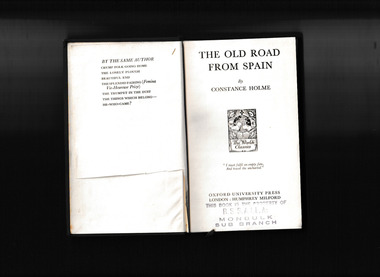 Mrs Aeneas Gunn Memorial Library
Book, Oxford University Press, The old road from Spain, 1932
... England - Adventure fiction English fiction The landscape ...The landscape, social life, and rural traditions of Holme’s native Westmorland are vividly evoked in The Old Road from Spain, the story of two brothers. When the younger brother arrives home from Spain it disrupts the even tenor of life in their Westmorland home. Meanwhile, a wreck in Morecambe bay links the story back to the Spanish Armada.p.282.fictionThe landscape, social life, and rural traditions of Holme’s native Westmorland are vividly evoked in The Old Road from Spain, the story of two brothers. When the younger brother arrives home from Spain it disrupts the even tenor of life in their Westmorland home. Meanwhile, a wreck in Morecambe bay links the story back to the Spanish Armada.england - adventure fiction, english fiction -
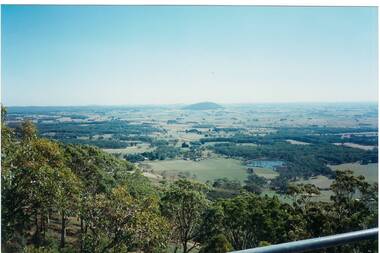 Buninyong & District Historical Society
Photograph - Colour photograph, Mt. Warrenheip
... . Buninyong Tower 1995 The view of Mt. Warrenheip shows the rural ...Distant view of Mt. Warrenheip Lookout tower from Mt. Buninyong Tower 1995The view of Mt. Warrenheip shows the rural landscape from Mt. Buninyong in the late twentieth centuryDistant view of Mt. Warrenheip looking North from Mt. Buninyong Lookout TowerFrom the Mt. Buninyong Tower, Feb 1995mt. warrenheip, landscape -
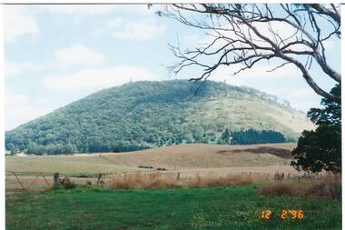 Buninyong & District Historical Society
Photograph - Colour photograph, Mt. Buninyong
... of Mt. Buninyong shows the rural landscape in the late twentieth ...View of Mt. Buninyong taken as a record, 1996The view of Mt. Buninyong shows the rural landscape in the late twentieth century View of Mt. Buninyong looking East from Harbours Road, YendonMt. Buninyong from Harbours Rd, Scotsburn - Yendon Rd. landscape, mt. buninyong, agriculture -
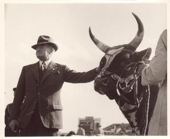
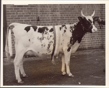 Melbourne Royal
Photograph, Frank Johnson, 1953
Black and white photograph of a black and white cow with horns. Champion sash from 1953This item is a part of a larger collection of 4,500 Frank Johnson photographs and negatives donated to Melbourne Royal by Frank Johnson’s daughter, Francis Beatty Wallace in 2016. This collection spanning from the 1930s to the 1980s holds important social and historical significance in preserving and sharing Victoria’s agricultural history and community. The photographs capture the local, regional, and state’s shared relationships developed through agriculture and the importance of farming and husbandry to the population and development of Australia. A large proportion of these photographs depict events from the Royal Melbourne Show, including livestock competitions, exhibitions and awards ceremonies. Dating back to 1848 when the society first began, the Royal Melbourne Show has held a special place in the hearts and minds of Victorians, allowing for extensive showcasing and celebration of agricultural excellence, bridging the divide between metropolitan and rural Victoria.A black and white photograph, landscape, printed on gloss paper with a white borderroyal melbourne show, cattle, cow, winners, blue ribbon competition, agricultural shows -
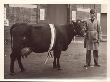
 Melbourne Royal
Photograph, Frank Johnson, 1954
Black and white photograph of a man standing with a long horned cow. The cow has a ribbon from the Royal Melbourne Coronation Show across its head, but it is unclear what colour (and therefore placing) it has received.This item is a part of a larger collection of 4,500 Frank Johnson photographs and negatives donated to Melbourne Royal by Frank Johnson’s daughter, Francis Beatty Wallace in 2016. This collection spanning from the 1930s to the 1980s holds important social and historical significance in preserving and sharing Victoria’s agricultural history and community. The photographs capture the local, regional, and state’s shared relationships developed through agriculture and the importance of farming and husbandry to the population and development of Australia. A large proportion of these photographs depict events from the Royal Melbourne Show, including livestock competitions, exhibitions and awards ceremonies. Dating back to 1848 when the society first began, the Royal Melbourne Show has held a special place in the hearts and minds of Victorians, allowing for extensive showcasing and celebration of agricultural excellence, bridging the divide between metropolitan and rural Victoria.A black and white photograph, landscape, printed on gloss paper with a white borderroyal melbourne show, cattle, cow, agricultural shows, blue ribbon competitions -
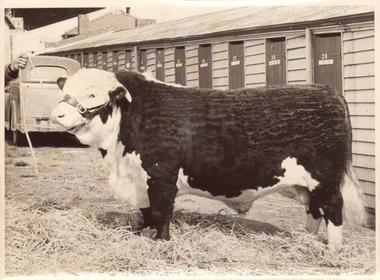
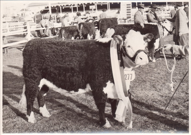 Melbourne Royal
Photograph, Frank Johnson, 1954
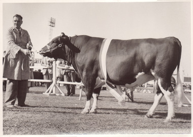
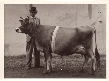
Champion Poll Hereford Cow. The Brass Maple 17th. JA Hanson "The Braes" MacarthurThis item is a part of a larger collection of 4,500 Frank Johnson photographs and negatives donated to Melbourne Royal by Frank Johnson’s daughter, Francis Beatty Wallace in 2016. This collection spanning from the 1930s to the 1980s holds important social and historical significance in preserving and sharing Victoria’s agricultural history and community. The photographs capture the local, regional, and state’s shared relationships developed through agriculture and the importance of farming and husbandry to the population and development of Australia. A large proportion of these photographs depict events from the Royal Melbourne Show, including livestock competitions, exhibitions and awards ceremonies. Dating back to 1848 when the society first began, the Royal Melbourne Show has held a special place in the hearts and minds of Victorians, allowing for extensive showcasing and celebration of agricultural excellence, bridging the divide between metropolitan and rural Victoria.A black and white photograph, landscape, printed on gloss paper with a white borderChampion Poll Hereford Cow. The Brass Maple 17th. JA Hanson "The Braes" Macarthurroyal melbourne show, cattle, hereford, cow, winner, blue ribbon competition, agricultural shows, mcarthur, hanson, ja hanson -
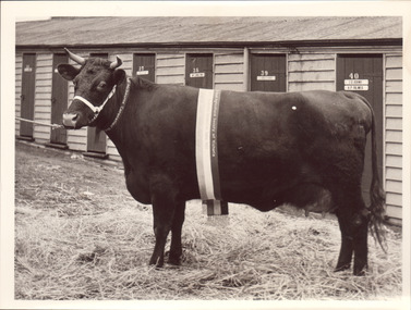
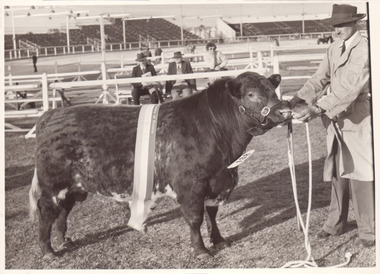
 Melbourne Royal
Photograph, Frank Johnson, 1953
Black and white photograph of a Champion cow, possibly a shorthorn, 1953This item is a part of a larger collection of 4,500 Frank Johnson photographs and negatives donated to Melbourne Royal by Frank Johnson’s daughter, Francis Beatty Wallace in 2016. This collection spanning from the 1930s to the 1980s holds important social and historical significance in preserving and sharing Victoria’s agricultural history and community. The photographs capture the local, regional, and state’s shared relationships developed through agriculture and the importance of farming and husbandry to the population and development of Australia. A large proportion of these photographs depict events from the Royal Melbourne Show, including livestock competitions, exhibitions and awards ceremonies. Dating back to 1848 when the society first began, the Royal Melbourne Show has held a special place in the hearts and minds of Victorians, allowing for extensive showcasing and celebration of agricultural excellence, bridging the divide between metropolitan and rural Victoria.A black and white photograph, landscape, printed on gloss paper with a white borderroyal melbourne show, cattle, cow, blue ribbon competitions, agricultural shows, winners -
 Melbourne Royal
Photograph, Frank Johnson, 1953
Black and white photograph of a Champion shorthorn cow 1953This item is a part of a larger collection of 4,500 Frank Johnson photographs and negatives donated to Melbourne Royal by Frank Johnson’s daughter, Francis Beatty Wallace in 2016. This collection spanning from the 1930s to the 1980s holds important social and historical significance in preserving and sharing Victoria’s agricultural history and community. The photographs capture the local, regional, and state’s shared relationships developed through agriculture and the importance of farming and husbandry to the population and development of Australia. A large proportion of these photographs depict events from the Royal Melbourne Show, including livestock competitions, exhibitions and awards ceremonies. Dating back to 1848 when the society first began, the Royal Melbourne Show has held a special place in the hearts and minds of Victorians, allowing for extensive showcasing and celebration of agricultural excellence, bridging the divide between metropolitan and rural Victoria.A black and white photograph, landscape, printed on gloss paper with a white borderroyal melbourne show, shorthorn, cattle, cow, agricultural shows, winners, blue ribbon competitions -
 Melbourne Royal
Photograph, Frank Johnson, 1954
Black and white photograph of a Champion Friesian Bull Champion Friesian Bull. Glenhope Keystone Burkeyje. FJ Fox "Kingstone Park" Merricks NorthThis item is a part of a larger collection of 4,500 Frank Johnson photographs and negatives donated to Melbourne Royal by Frank Johnson’s daughter, Francis Beatty Wallace in 2016. This collection spanning from the 1930s to the 1980s holds important social and historical significance in preserving and sharing Victoria’s agricultural history and community. The photographs capture the local, regional, and state’s shared relationships developed through agriculture and the importance of farming and husbandry to the population and development of Australia. A large proportion of these photographs depict events from the Royal Melbourne Show, including livestock competitions, exhibitions and awards ceremonies. Dating back to 1848 when the society first began, the Royal Melbourne Show has held a special place in the hearts and minds of Victorians, allowing for extensive showcasing and celebration of agricultural excellence, bridging the divide between metropolitan and rural Victoria.A black and white photograph, landscape, printed on gloss paper with a white borderChampion Friesian Bull. Glenhope Keystone Burkeyje. FJ Fox "Kingstone Park" Merricks Northroyal melbourne show, friesian, bull, agricultural shows, blue ribbon competitions, winners, glenhope, kingstone, fj fox, fox -
 Melbourne Royal
Photograph, Frank Johnson, 1954
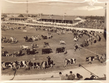
Grand Parades on the main arena were a popular Melbourne Royal Show attraction and tradition. The first was in 1910 - prior to this, horses and cattle had been paraded around the arena separately, but at this particular Show they were paraded together for the first time in a ‘Massed’ (Grand) Parade. This innovation proved very popular with exhibitors and the general public alike. The last Grand Parade was in 2004.This item is a part of a larger collection of 4,500 Frank Johnson photographs and negatives donated to Melbourne Royal by Frank Johnson’s daughter, Francis Beatty Wallace in 2016. This collection spanning from the 1930s to the 1980s holds important social and historical significance in preserving and sharing Victoria’s agricultural history and community. The photographs capture the local, regional, and state’s shared relationships developed through agriculture and the importance of farming and husbandry to the population and development of Australia. A large proportion of these photographs depict events from the Royal Melbourne Show, including livestock competitions, exhibitions and awards ceremonies. Dating back to 1848 when the society first began, the Royal Melbourne Show has held a special place in the hearts and minds of Victorians, allowing for extensive showcasing and celebration of agricultural excellence, bridging the divide between metropolitan and rural Victoria.A sepia photograph, landscape, printed on gloss paper with a white border.royal melbourne show, grand parade, cattle, horses, main arena, melbourne showgrounds, agricultural shows -
 Melbourne Royal
Photograph, Frank Johnson, 1954
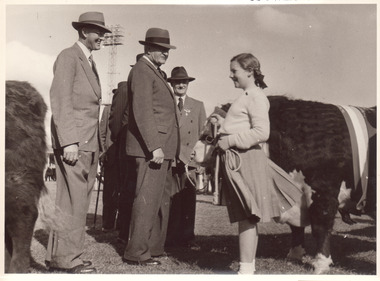
Black and white photograph of cattle judges speaking to a young girl leading a hereford bullThis item is a part of a larger collection of 4,500 Frank Johnson photographs and negatives donated to Melbourne Royal by Frank Johnson’s daughter, Francis Beatty Wallace in 2016. This collection spanning from the 1930s to the 1980s holds important social and historical significance in preserving and sharing Victoria’s agricultural history and community. The photographs capture the local, regional, and state’s shared relationships developed through agriculture and the importance of farming and husbandry to the population and development of Australia. A large proportion of these photographs depict events from the Royal Melbourne Show, including livestock competitions, exhibitions and awards ceremonies. Dating back to 1848 when the society first began, the Royal Melbourne Show has held a special place in the hearts and minds of Victorians, allowing for extensive showcasing and celebration of agricultural excellence, bridging the divide between metropolitan and rural Victoria.A black and white photograph, landscape, printed on gloss paper with a white borderroyal melbourne show, cattle, hereford, bull, kids at show, judging, agricultural shows, blue ribbon competitions -
 Melbourne Royal
Photograph, Frank Johnson, 1954
Black and white photograph of a Champion Jersey cow 1953This item is a part of a larger collection of 4,500 Frank Johnson photographs and negatives donated to Melbourne Royal by Frank Johnson’s daughter, Francis Beatty Wallace in 2016. This collection spanning from the 1930s to the 1980s holds important social and historical significance in preserving and sharing Victoria’s agricultural history and community. The photographs capture the local, regional, and state’s shared relationships developed through agriculture and the importance of farming and husbandry to the population and development of Australia. A large proportion of these photographs depict events from the Royal Melbourne Show, including livestock competitions, exhibitions and awards ceremonies. Dating back to 1848 when the society first began, the Royal Melbourne Show has held a special place in the hearts and minds of Victorians, allowing for extensive showcasing and celebration of agricultural excellence, bridging the divide between metropolitan and rural Victoria.A black and white photograph, landscape, printed on gloss paper with a white borderroyal melbourne show, jersey, cow, cattle, 1953 royal melbourne coronation show, blue ribbon competitions, winners, agricultural shows -
 Melbourne Royal
Photograph, Frank Johnson, 1953
A Champion bull (small) 1953This item is a part of a larger collection of 4,500 Frank Johnson photographs and negatives donated to Melbourne Royal by Frank Johnson’s daughter, Francis Beatty Wallace in 2016. This collection spanning from the 1930s to the 1980s holds important social and historical significance in preserving and sharing Victoria’s agricultural history and community. The photographs capture the local, regional, and state’s shared relationships developed through agriculture and the importance of farming and husbandry to the population and development of Australia. A large proportion of these photographs depict events from the Royal Melbourne Show, including livestock competitions, exhibitions and awards ceremonies. Dating back to 1848 when the society first began, the Royal Melbourne Show has held a special place in the hearts and minds of Victorians, allowing for extensive showcasing and celebration of agricultural excellence, bridging the divide between metropolitan and rural Victoria.A black and white photograph, landscape, printed on gloss paper with a white border[on bull's neck number] 138royal melbourne show, bull, cattle, blue ribbon competitions, agricultural shows -
 Melbourne Royal
Photograph, Frank Johnson, 1954
Black and white photograph of a hereford bullThis item is a part of a larger collection of 4,500 Frank Johnson photographs and negatives donated to Melbourne Royal by Frank Johnson’s daughter, Francis Beatty Wallace in 2016. This collection spanning from the 1930s to the 1980s holds important social and historical significance in preserving and sharing Victoria’s agricultural history and community. The photographs capture the local, regional, and state’s shared relationships developed through agriculture and the importance of farming and husbandry to the population and development of Australia. A large proportion of these photographs depict events from the Royal Melbourne Show, including livestock competitions, exhibitions and awards ceremonies. Dating back to 1848 when the society first began, the Royal Melbourne Show has held a special place in the hearts and minds of Victorians, allowing for extensive showcasing and celebration of agricultural excellence, bridging the divide between metropolitan and rural Victoria.A black and white photograph, landscape, printed on gloss paper with a white borderroyal melbourne show, hereford, bull, agricultural shows, blue ribbon competitions -
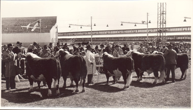 Melbourne Royal
Photograph, Frank Johnson, 1954
Black and white photograph of a poll Hereford bulls lined up for judgingThis item is a part of a larger collection of 4,500 Frank Johnson photographs and negatives donated to Melbourne Royal by Frank Johnson’s daughter, Francis Beatty Wallace in 2016. This collection spanning from the 1930s to the 1980s holds important social and historical significance in preserving and sharing Victoria’s agricultural history and community. The photographs capture the local, regional, and state’s shared relationships developed through agriculture and the importance of farming and husbandry to the population and development of Australia. A large proportion of these photographs depict events from the Royal Melbourne Show, including livestock competitions, exhibitions and awards ceremonies. Dating back to 1848 when the society first began, the Royal Melbourne Show has held a special place in the hearts and minds of Victorians, allowing for extensive showcasing and celebration of agricultural excellence, bridging the divide between metropolitan and rural Victoria.A black and white photograph, landscape, printed on gloss paper with a white border[printed and taped on the reverse] Poll Hereford line up for Ch. Bullroyal melbourne show, hereford, bull, cattle, livestock, blue ribbon competitions, agricultural shows, judging -
 Eltham District Historical Society Inc
Photograph - Digital Photograph, Alan King, Downing-Le Gallienne house, Yarra Braes Road, Eltham, 30 January 2008
The property is a classic example of what made Eltham famous from the late 1940s to the 1960s. Covered under Heritage Overlay, Nillumbik Planning Scheme. Published: Nillumbik Now and Then / Marguerite Marshall 2008; photographs Alan King with Marguerite Marshall.; p149 The first view of the large double-storey house at Yarra Braes Road, Eltham South, is of a jutting roofline over a balcony, reminiscent of a large sailing vessel or galleon – very appropriate, considering the name of one of the first owners, Le Gallienne. The Downing-Le Gallienne property is a classic example of what made Eltham famous from the late 1940s to the 1960s and attracted so many artists and intellectuals to the area. Set in a largely indigenous bush-style garden, the mud-brick and timber house was built by Alistair Knox. It was built for economist Richard Downing, to become a founder of the welfare state in Australia and Chairman of the Australian Broadcasting Commission, and musician and composer Dorian Le Gallienne. Le Gallienne was a pioneering composer of modern music in Victoria before 1945, whose works included the Symphony in E.1 He wrote several pieces of film music for Eltham Films, including The Prize, working with its writer and artistic director Tim Burstall. Le Gallienne was also a music critic for The Argus and later for The Age. In 1967 the music critic Roger Covell argued that Le Gallienne’s Symphony, was ‘still the most accomplished and purposive . . . written by an Australian’. According to Alan Marshall the main inspiration behind the building that evolved from 1948 to 1964 was Le Gallienne. ‘He was able to see value in the simplest things and many who worked there had their eyes opened for the first time to the Eltham environment, to the bush and the trees and the fauna which lived there.’ The garden included no formality, no lawns, nor exotic plants. ‘Natural informal growth came right up to their doors and so did the indigenous birdlife.’ This informal style – consisting of mass and void – was to be developed and popularised by landscaper Gordon Ford from the 1950s. The large mud-brick and timber house, which was built in four stages and has three separate but linked sections, began as a small weekend retreat for the couple. In 1948, Downing and Le Gallienne (Dick and Dor to their friends), asked Knox to build the 36 x18 foot (11mx5.4m) building with a pitched slate roof. It was built on a concrete slab and included a fireplace, which is still in use. The second wing was built in 1954 after Downing had returned from working at the International Labour Office and the couple decided to live there full-time. The third section was built after the death of Le Gallienne in 1963, aged 48. He is buried in the Eltham Cemetery. When Downing married widow, Jean Norman (nee McGregor) and had to accommodate a large family, including her six children and one of their own, the last stage was built by 1964. At that time the house was considered one of the largest mud-brick houses in Victoria. It consists of five living areas, including a small ballroom. Several artists helped Knox build the Downing-Le Gallienne house, which was one of his first of mud-brick. They included painter Clifton Pugh, artist John Howley and actor Wynn Roberts. Ellis Stones had landscaped the first wing and Gordon Ford set the boulder steps and made a pool as part of the landscaping he completed. Inside, the mud-bricks are largely whitewashed with pine-lined ceilings and Oregon beams. A winding timber staircase in the front extends behind a glass window from the ground floor to the top. The property, of a little more than 0.5 ha, is bordered by Parks Victoria land, which extends to the Yarra River.This collection of almost 130 photos about places and people within the Shire of Nillumbik, an urban and rural municipality in Melbourne's north, contributes to an understanding of the history of the Shire. Published in 2008 immediately prior to the Black Saturday bushfires of February 7, 2009, it documents sites that were impacted, and in some cases destroyed by the fires. It includes photographs taken especially for the publication, creating a unique time capsule representing the Shire in the early 21st century. It remains the most recent comprehenesive publication devoted to the Shire's history connecting local residents to the past. nillumbik now and then (marshall-king) collection, dorian le gallienne, downing-le gallienne house, eltham, mudbrick construction, mudbrick houses, richard downing, yarra braes road -
 Bendigo Historical Society Inc.
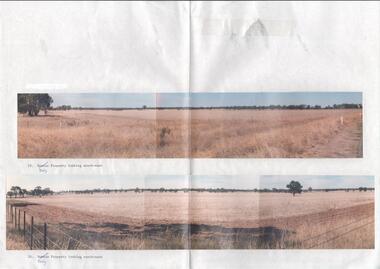
Photograph - Kangaroo Flat Gold Mine Collection: photos of Woodvale site, Daly property, pre dam construction, 1986
Photographs taken at the time of the purchase by Western Mining Corporation of the property owned by G.P. Daly of Raywood Road, Woodvale, in 1986. The intent of the purchase was to provide land for the Woodvale ponds. Land size was 16 acres, known as Allotment 13, Section 3, Parish of Nerring. Paper with two colour photographs attached, each of three photos joined to show landscape view, of the property purchased from G.P Daly by Western Mining Corporation. Photographs show rural land, grassy paddocks with tree line in background. Barb wire fence visible in foreground of bottom photo. Top photograph is titled 23. Daly property looking south-east. Bottom photograph is titled 24. Daly property looking north east. woodvale, g.p. daly, western mining corporation, purchase -
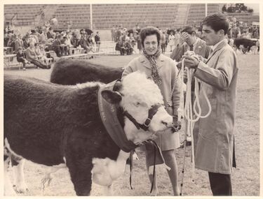 Melbourne Royal
Photograph, Frank Johnson, 1969
This photograph shows the Champion Poll Hereford Bull at the 1969 Royal Melbourne Show. The animal is exhibit 536, Springfield Hiawatha, exhibited by S, K & C Hawkins. The people in the photograph are Thea Manson and Terry Ryan, who was stud-groom at Springfield Poll Herefords in Finley NSW.This item is a part of a larger collection of 4,500 Frank Johnson photographs and negatives donated to Melbourne Royal by Frank Johnson’s daughter, Francis Beatty Wallace in 2016. This collection spanning from the 1930s to the 1980s holds important social and historical significance in preserving and sharing Victoria’s agricultural history and community. The photographs capture the local, regional, and state’s shared relationships developed through agriculture and the importance of farming and husbandry to the population and development of Australia. A large proportion of these photographs depict events from the Royal Melbourne Show, including livestock competitions, exhibitions and awards ceremonies. Dating back to 1848 when the society first began, the Royal Melbourne Show has held a special place in the hearts and minds of Victorians, allowing for extensive showcasing and celebration of agricultural excellence, bridging the divide between metropolitan and rural Victoria.A black and white, landscape photograph printed on card.royal melbourne show, manson, thea manson, ryan, terry ryan, springfield poll hereford, poll hereford, hereford, cattle, beef cattle, bull, livestock, blue ribbon competition, beef cattle competition, agricultural show, champion, grand champion, grand champion bull, winners, 1969 royal melbourne show