Showing 16975 items
matching snowy-river-bridge-1976
-
 Tarnagulla History Archive
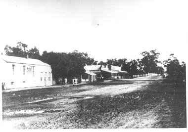
Photographs: Buildings in Newbridge near Loddon River bridge, Buildings in Newbridge near Loddon River bridge, 1908 (original image)
Depicts at left, Petersen's bakery, a store shed, Simpson's storekeepers and Simpson's Hotel. Hollands blacksmith shop & wheelwrights on right opposite bakery. Murray Comrie Collection. Three copies of a monochrome photograph, image depicts buildings in the eastern approach to the Loddon River bridge at Newbridge This is a fairly dark copy of an older original. Copy probably made by Murray Comrie in the 1960s.newbridge, loddon river, bridge, shops, stores, businesses, hotels, simpsons, petersens, bakery -
 Kiewa Valley Historical Society
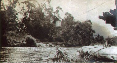
Photo - Tawonga Bridge.( Set of 2 photos)
Photo 1 - Rene Roper (Postmistress) crossing swollen Kiewa River on a milk can flying fox at Tawonga, during high winter waters Photo 2 - First Tawonga bridge was built in 1884- destroyed by floods in 1916. New bridge constructed 1923 and destroyed in 1953. Present concrete bridge constructed in 1986 and named Ryders BridgeBridge construction over Kiewa River at TawongaCopies of two original black and white photos. Photo 1 - Flying fox at site of Tawonga Bridge over the Kiewa River Photo 2 - Timber pile bridge over the Kiewa River at Tawongatawonga bridge, kiewa valley -
 Kew Historical Society Inc
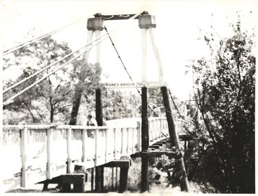
Photograph - Photograph (copy), Kanes Bridge, Studley Park, 195-1955
In 1928 a footbridge was erected to link Kew with the public golf course across the Yarra. The total cost of construction came to 250 pounds and the bridge became known as Kane's Bridge. During the 1934 floods the bridge was washed downstream, and was subsequently rebuilt. The present form of the bridge resembles the earlier bridge which crossed from the Yarra Bend Asylum to Kew, further upstream. (VHD)This work forms part of the collection assembled by the historian Dorothy Rogers, that was donated to the Kew Historical Society by her son John Rogers in 2015. The manuscripts, photographs, maps, and documents were sourced by her from both family and local collections or produced as references for her print publications. Many were directly used by Rogers in writing ‘Lovely Old Homes of Kew’ (1961) and 'A History of Kew' (1973), or the numerous articles on local history that she produced for suburban newspapers. Most of the photographs in the collection include detailed annotations in her hand. The Rogers Collection provides a comprehensive insight into the working habits of a historian in the 1960s and 1970s. Together it forms the largest privately-donated collection within the archives of the Kew Historical Society.A photographic copy of an older photograph of Kanes Bridge."Kanes Bridge"kanes bridge, yarra river, bridges - kew (vic.) -
 Eltham District Historical Society Inc
Slide - Photograph, Russell Yeoman, Para Road / Carter Street Bridge over the Plenty River, Briar Hill, c.Jul 1969
Bridge over the Plenty River at Briar Hill before widening and alterations. The Plenty River at Briar Hill represented the boundary between the Shire of Eltham and the Shire of Diamond Valley. The bridge was known as the Carter Street Bridge as prior to 1969 Para Road, Briar Hill became Carter Street, Greensborough across the river. It was at this time that the name Para Road was continued and replaced Carter Street.35mm colour positive transparency blue Agfacolour Service plastic mount1969-07, briar hill, carter street bridge, para road, para road bridge, shire of diamond valley, shire of eltham, bridge, plenty river, shire of eltham pioneers photograph collection -
 Eltham District Historical Society Inc
Negative - Photograph, Russell Yeoman, Para Road / Carter Street Bridge over the Plenty River, Briar Hill, c.Jul. 1969
Bridge over the Plenty River at Briar Hill before widening and alterations. The Plenty River at Briar Hill represented the boundary between the Shire of Eltham and the Shire of Diamond Valley. The bridge was known as the Carter Street Bridge as prior to 1969 Para Road, Briar Hill became Carter Street, Greensborough across the river. It was at this time that the name Para Road was continued and replaced Carter Street.This photo forms part of a collection of photographs gathered by the Shire of Eltham for their centenary project book,"Pioneers and Painters: 100 years of the Shire of Eltham" by Alan Marshall (1971). The collection of over 500 images is held in partnership between Eltham District Historical Society and Yarra Plenty Regional Library (Eltham Library) and is now formally known as the 'The Shire of Eltham Pioneers Photograph Collection.' It is significant in being the first community sourced collection representing the places and people of the Shire's first one hundred years.Digital image 35 mm B&W negativeshire of eltham pioneers photograph collection, briar hill, 1969-07, bridge, carter street bridge, para road, para road bridge, plenty river, shire of diamond valley, shire of eltham -
 Stawell Historical Society Inc
Photograph, Old Wooden Bridge - over the Wimmera River at Joel Joel -- Coloured
Wooden Bridge - Joel Joel (Wimmera River) stawell shire -
 Stawell Historical Society Inc
Photograph, Old Campbells Bridge over Wimmera River
Old Campbells Bridge over Wimmera Riverstawell shire -
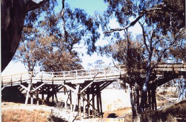
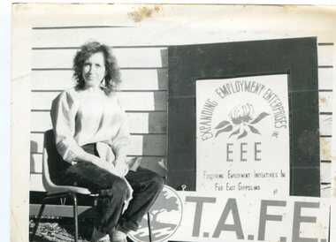 Orbost & District Historical Society
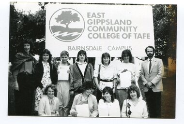
black and white photograph, Snowy River Mail
The Orbost Education Centre has been in operation since 1976 and is run by a team of volunteers and paid staff. Programs and activities offered respond to the needs of the local community and the Centre works closely with its community partners. It is supported by funding and goodwill from the community, state government and non-government organisations. TAFE offered adult education to those new out of school and mothers coming out of motherhood as well as others. This photograph is associated with Adult Learning in Orbost.A black / white photograph of a woman sitting on a chair next to a sign - :Expanding Employment Enterprises Fostering Employment Initiatives in Far East Gippsland T.A.F.E."education-adult-orbost t.a.f.e. -
 Eltham District Historical Society Inc
Photograph, Doug Orford, Completion of bridge works across Yarra River at rear of Eltham Lower Park, July 2004
Bitumen shared pathway under construction at the new Eltham-Templestowe footbridge over the Yarra River off Homestead Road, Eltham which was completed in July 2004. The Yarra River Footbridge was opened in August 2004 and links the Diamond Creek Trail between the Shire of Nillumbik and City of Manningham. It is a shared pathway and also links with the Main Yarra Trail. It affords lovely views over the Yarra River.Three colour photographs showing commencement of construction of Eltham-Templestowe footbridge over Yarra River off Homestead Road, Eltham which was completed July 2004. Third photograph of dedictaion plaque at opening 30 Aug 2004bridges, yarra river, eltham south, eltham lower park, lenister farm, homestead road, asphaldt, bitumen, shared pathway, diamond creek trail -
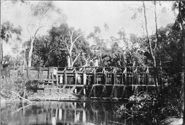 Stawell Historical Society Inc
Photograph, Weir on the Wimmera River between Glenorchy & Campbells Bridge -- Postcard
Weir on Wimmera River between Glenorchy & Campbells Bridgestawell -
 Stawell Historical Society Inc
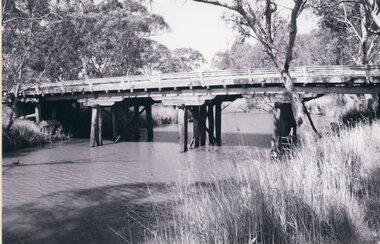
Photograph, Wooden Wimmera River Bridge at Glenorchy -- 2 Photos
Two photographs of Wooden Wimmera River Bridge at Glenorchystawell -
 Greensborough Historical Society
Photograph - Digital image, Old Bridge, Plenty River, 1911c
Photograph of old bridge over Plenty River, date unknown.Digital copy of black and white photograph.plenty river -
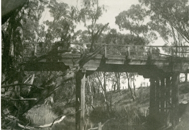
 Orbost & District Historical Society
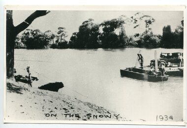
black and white photograph, 1934
This photograph shows vehicles and people being ferried across the Snowy River during the 1934 flood. The Orbost punt was reinstated on a temporary basis following damage to the bridge. Damage estimated at £500,000 was caused by the 1934 floods in the Orbost district. This 1934 flood was devastating, destroying a section of the 1922 Orbost bridge, wrecking fences, bridges and roads, dumping silt and debris on the rich river flats and drowning cattle. The centre span of the Orbost Bridge was washed away.This is a pictorial record of the effects of the 1934 floods in the Orbost district.A large black / white photograph of a punt with a motor vehicle and people making their way across a river.on front - "On the Snowy 1934"snowy-river-orbost flood-1934 river-transport-punt -
 Lakes Entrance Regional Historical Society (operating as Lakes Entrance History Centre & Museum)
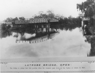
Photograph, Caire, Nicholas John, Swing Bridge Sale Victoria c1905, 1905c
Latrobe Bridge - Open. The bridge is swung into this position when the steamers pass down to the Lakes or return to Sale.Black and white photograph of the Latrobe River Bridge over the Latrobe River, shows the bridge open to river traffic, with a good view of the supporting structure. Sale Victoriawaterways, bridges, civil engineering -
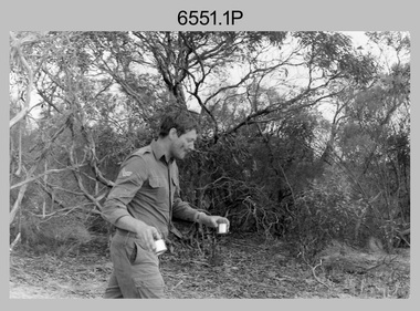 Bendigo Military Museum
Photograph - 4th Field Survey Squadron Regimental Training, Murray Bridge Training Area, SA, 1988
This is a set of eight photographs of 4th Field Survey Squadron personnel undergoing regimental training held at the Murray Bridge Training Area of South Australia in 1988. The aim of regimental training was typically to provide personnel a practical knowledge of infantry and minor tactics at the section level, navigation and map reading, RATEL and survival in the Field.This is a set of eight photographs of 4th Field Survey Squadron personnel undergoing regimental training held at the Murray Bridge Training Area of South Australia in 1988. The black and white photographs are on 35mm negative film and are part of the Army Survey Regiment’s Collection. The photographs were scanned at 96 dpi. .1) - Photo, black & white, 1988. CPL Steve McGuiness. .2) - Photo, black & white, 1988. L to R: Unidentified, SPR Charmian McKean. .3) - Photo, black & white, 1988. SPR Andrew Quin. .4) - Photo, black & white, 1988. L to R: Unidentified, LT Geoff ‘GT’ Ford. .5) & .6) - Photo, black & white, 1988. Unidentified personnel. .7) - Photo, black & white, 1988. L to R: Unidentified (x2), SPR Perry Langeberg, SGT Laurie Justin (3rd from right), remainder unidentified. .8) - Photo, black & white, 1988. L to R: Unidentified, SGT Laurie Justin, remainder unidentified..1P to .8P – There are no personnel identified. ‘1988 REGT ADV TRAINING MURRAY BRIDGE’ annotated on negatives sleeve.royal australian survey corps, rasvy, 4 fd svy sqn -
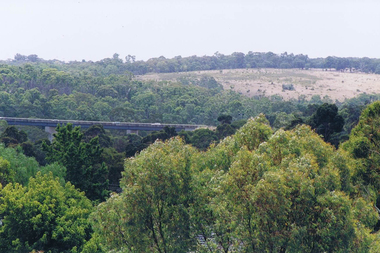 Greensborough Historical Society
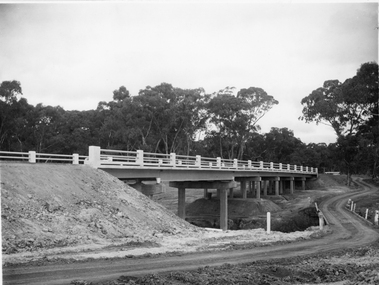
Photograph - Digital image, Frank Solomon, View over Greensborough to Plenty River Drive bridge, 2010c
View over trees to the Greensborough By-pass bridge over Plenty River Drive.Digital copy of colour photographplenty river drive, greensborough bypass -
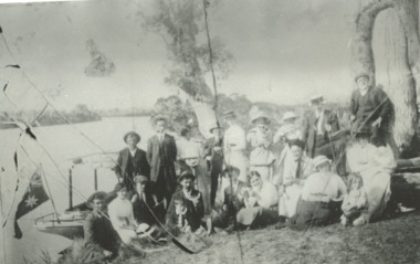 Lakes Entrance Regional Historical Society (operating as Lakes Entrance History Centre & Museum)
Photograph, Phillip Hancock, Howlett, Legg, Froud, Bly, Brideson, Bull, Bell, Thompson, Wilson Families on the bank of the Tambo River Gippsland Victoria, January 1915 c
James, Maud, Eva, May, Mabel Howlett, Fred, Marion, Alf, Gladys Legg, Carrie Froud, Jessie Bly, Lena Brideson, George Bull, Will Bell, Jim Thompson, Mr Wilson on the bank of the Tambo River Gippsland VictoriaBlack and white photograph showing small launch beside river and large Aboriginal canoe tree in background and eighteen adults and two children, genealogy, families -
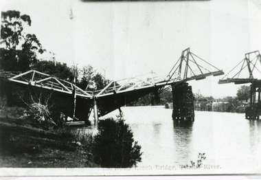 Lakes Entrance Regional Historical Society (operating as Lakes Entrance History Centre & Museum)
Photograph - Bridges, Bulmer H D, 1925
Swan Reach Bridge collapsed 10.00 am 16 November 1925Black and white photograph showing collapsed bridge over the Tambo River, bridge collapsed at eastern end. Photo looking downstream. Two people on landing on far right bank behind right hand bridge pylon. Thick vegetation on bank. Swan Reach VictoriaSwan Reach Bridge on the Tambo Riverwaterways, boats and boating, disasters -
 Orbost & District Historical Society
black and white photographs, Snowy River Mail, 1990
Wendy Blackburn was in charge of T.A..F.E. Orbost and the photographs were taken in her office. Also in the photographs are Tracey Barnett, Peter Cook and Dan Osborne. The Orbost Education Centre is a community based not-for-profit local organisation. It has been in operation since 1976. The programs respond to the needs of the community and short courses are delivered throughout the year for people of all ages and backgrounds. The basis is promoting learning, connectedness and belonging. It is supported by funding from the community, state government and non-government organisations. TAFE offered adult education to those new out of school and mothers coming out of motherhood as well as others. These photographs are pictorial records associated with adult education in Orbost.Five black / white photographs related to adult learning in Orbost. education-adult-orbost t.a.f.e.-orbost -
 Greensborough Historical Society
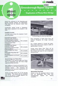
Newsletter, Vic Roads, Vic Roads , Greensborough Bypass Upgrade - Duplication of Plenty River Bridge, August 2005
Vic Roads Newsletter regarding the Greensborough Bypass Upgrade and duplication of the Plenty River Bridge.2 page Newsletter with print and black & white photosgreensborough bypass, vicroads, plenty ri, plenty river bridge -
 Orbost & District Historical Society
black and white photographs, 1915
This photograph is of the construction of the first road bridge over the Genoa River - 1915. Before today's timber truss and concrete bridge was constructed between 1926-1928 by contractor J.T. Noble Anderson, two earlier bridges crossed the Genoa River at this location. They provided crucial links in the Princes Highway route from Melbourne to Sydney. The letter on the back of the postcard was written by Gordon ? to Alex ? on 2nd October 1917. "this represents the opening of Genoa Bridge. Mrs Alexander cutting the ribbon and Mr Martin holding it at the other side. Did most of the speaking. The gent holding the roll of paper is who came to open the bridge. I can't think of his name. Hubert is standing up at the right / Gordon " This is a pictorial record associated with the history of Genoa in East Gippsland.1100 -A large black / white photograph on a cream coloured buff card. It is of an unfinished bridge with men working there. A small rowboat can be seen on the far side of the river. 1100.1 - A photograph / postcard of the opening of "Genoa Bridge 1917". There is a ribbon stretched across the timber decking road in front of a group of people. 1100.2 - A black / white photograph of a road bridge across a river.on back - "Princes Highway - the 1st bridge over the Genoa River - 1915" on back of 1100.1 is a hand-written letter.genoa-bridge princes-highway-east-gippsland -
 Ringwood RSL Sub-Branch
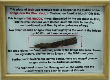
Souvenir Framed item, Piece of bridge from the Burma Railway, C 1987
Wooden frame with text and a piece of teak from the Bridge over the River Kwai.Collected from the bridge on 10th March 1987. -
 Winchelsea and District Historical Society
Photograph, Old wooden bridge and New Bluestone Bridge circa 1867
photograph taken circa 1867/8 Original wooden bridge built about 1857Photo of Blue stone bridge, as is today This photo is important, shows Winchelsea before many buildings.Very early Winchelsea circa 1867/8.photo taken from opposite old Library. Early wooden bridge right foreground and present bluestone bridge centre foreground. First Shire Hall and Dr. Meyler,s residence right above wooden bridge. On the left is Stirling's StoreOld wooden Bridge and New Bluestone Bridge circa 1867. Winchelsea Shire Hall top right (First Shire Hall).bridge, dr. meyler, stirling's store, first shire hall, wooden. -
 Greensborough Historical Society
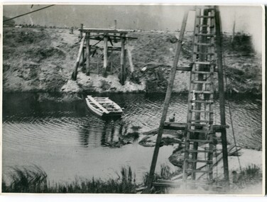
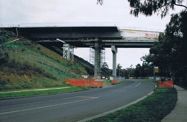
Photograph - Digital image, Frank Solomon, Plenty River Drive Bridge Roadworks 1, 1995c
These photos show the duplication of the bridge over Plenty River Drive on the Greensborough Bypass, circa 1995.Digital copy of colour photographplenty river drive, greensborough bypass -
 Greensborough Historical Society
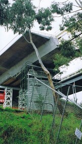
Photograph - Digital image, Frank Solomon, Plenty River Drive Bridge Roadworks 3, 2005c
These photos show the duplication of the bridge over Plenty River Drive on the Greensborough Bypass, circa 2005.Digital copy of colour photographplenty river drive, greensborough bypass -
 Greensborough Historical Society
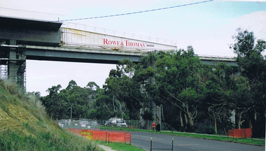
Photograph - Digital image, Frank Solomon, Plenty River Drive Bridge Roadworks 4, 2005c
These photos show the duplication of the bridge over Plenty River Drive on the Greensborough Bypass, circa 2005.Digital copy of colour photographplenty river drive, greensborough bypass -
 Stawell Historical Society Inc
Photograph, Campbell’s Bridge over the Wimmera River 1961
Newly built Campbell’s Bridge over the Wimmera River. Built by Redman Bros. Opened in 1961.stawell shire -
 Orbost & District Historical Society
black and white photographs, Snowy River Mail, 1990
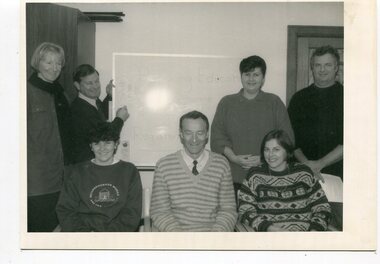
These photographs are related to adult Learning in Orbost.. They are connected to the "East Gippsland Community College of T.A.F.E. Bairnsdale Campus" The Orbost Education Centre has been in operation since 1976 and is run by a team of volunteers and paid staff. Programs and activities offered respond to the needs of the local community and the centre works closely with its community partners. It is supported by funding and goodwill from the community, state government and non-government organisations. TAFE offered adult education to those new out of school and mothers coming out of motherhood as well as others. In the photographs are: Janet Hambling; Irene Rowley; Clive Jenkins; Keith Knight; Wendy Major; Wendy Blackburn; Peter Bommer; Helen Shiels, Jeff Wilson and Peter Griebenow.These photographs are associated with Adult Learning in Orbost.Seven black / white photographs related to Adult Education in Orbost. education-adult-orbost t.a.f.e.-orbost -
 Greensborough Historical Society
Photograph - Digital image, Bridge over Plenty River, 1930-1940
Photograph of old bluestone bridge over the Plenty River in Greensborough. This photo is from the Lorraine Coates Collection.Digital copy of black and white photograph.plenty river greensborough, bluestone bridge greensborough -
 Stawell Historical Society Inc
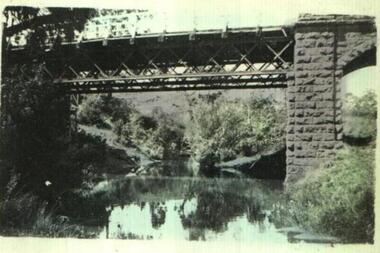
Photograph, Glenorchy Bridge on the Wimmera River 1866
Glenorchy Bridge Wimmera River. Part of a collection of Photographs by Mr. O.G. Armstrong as commissioned by the Shire of Stawell for the Inter-colonial and Paris Exhibition in Melbourne in 1866. Prior to the construction of this bridge in 1860, there existed two forwards across the Wimmer River at Glenorchy. One was 2 miles on the Stawell side of Glenorchy and 500 metres from the present railway bridge. It was well made, stone floor and can be seen today. The second was located 800 metres downstream of the town and was known as Stuart’s Crossing. These Fords were popular crossing spots for Bullock Drays which were delayed for days during floods before the bridge was built. The original Bridge was built near the site of the present ‘old’ bridge. stawell