Showing 325 items
matching south avenue
-
 Ballarat Tramway Museum
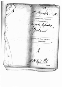
Document - Photocopy, Public Records Office of Victoria, "Proceedings of Inquest - Elizabeth Clarke, Ballarat", 19/02/2007 12:00:00 AM
Yields information about a serious head on collision between two trams in Wendouree Parade, issues with the systems and tramcars and training. Gives extensive details of the accident and its consequences.Twenty Seven page photocopy of a Coroner's Inquest and proceedings into the death of Elizabeth Clark in Ballarat following a collision between Scrubber Tram and No. 26 in Wendouree Parade, 5/2/1936, near Barrett Avenue. The Coroners Inquest was held on 4/3/1936. The copy of the inquest from the Public Records Office Victoria - VPRS 24/P/O, unit 1303, file 1936/302. For detail scans of photographs by the Police Photographer see Reg. Item 3688. Contains witness statements by: Henry Morganti (Barrister & Solicitor), Dr. William Griffiths, Lillian Oliver (passenger on tram), Jean Oliver (passenger on tram), George Stock (Police Photographer), Alfred Forte (SEC - Tram track assistant), Albert Mawby (Inspector - SEC), Frederick Thompson (Driver of No. 26), John Tucker (Driver of the Scrubber Car) and 1st Constable Roy Vinnicombe (Victoria Police).On rear - PROV stamp and file number.trams, tramways, accidents, collision, coroners inquests, wendouree parade, barrett ave -
 Ballarat Tramway Museum
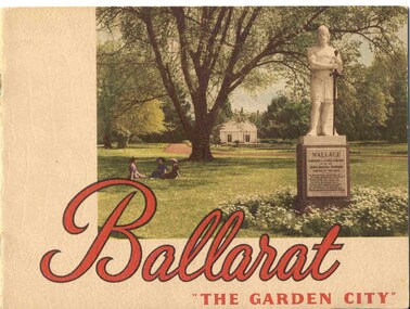
Book, Nu-color-vue or Nucolorvue Productions, "Ballarat - 'The Garden City' ", late 1940's or early 1950s
Yields information about Ballarat through pictures of the 1940-50's various locations, institutions and street scenes, including tramways. Good comparison with earlier books, eg Item 3900.24 page book, plus embossed covers saddle stapled with two staples titled "Ballarat - 'The Garden City' ". Features photographs of Ballarat and district - full colour with accompanying text about Ballarat and its history. Cover features Gardens view with statute of Wallace in foreground - see image c1 p3 - photo of No. 22 (bogie) at Grenville St in Sturt St with a single trucker behind in the City loop - see image c2 - see also Reg Item 5354 for a postcard version. p5 - Eureka Stockade memorial p6 - Lake Wendouree p7 - Sturt St with Town hall in background, and No. 33 in Sturt St. south side. p9 - Begonia hothouse p10 - St Andrews Kirk p11 - St Peter's Church of England p12 - Lake Wendouree p13 - Botanical Gardens p14 - Monuments and statues around Ballarat p15 - Post Office, State Offices, Ballarat Orphanage and Queen Elizabeth Benevolent Home p16 - A Ballarat Reservoir p17 - Botanical Gardens p18 - Gordon's Cottage, Congregational Church, Lydiard St and The Cenotaph p19 - Ballarat Grammar School, St. Patrick's Cathedral (no spire), St. Patrick's College, street scene p20 - Arch of Victory, Lake Wendouree, Sturt St with tram in distance and Eureka Swimming pool p22 - Avenue of Prime Ministers p23 - Harvest near Mt Warrenheip, Country side photo, I&R Morley Pty Ltd factory and houses in the lake area. Purchased through eBay 25/10/2004. See worksheet for eBay emails. See also Reg. Item 3041 for the same image of No. 22. 2nd Copy added 26/12/2007 - donation of Ron Scholten. pdf image of the full book added 8/5/19 as btm2925i.pdf trams, tramways, ballarat, sturt st, history, gardens -
 Ballarat Tramway Museum
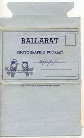
Postcard - Folder set, Valentine & Sons Publishing Co, "Ballarat Photographic Booklet", 1940's
Shows views of the Ballarat CBD and nearby features in the 1930's and 1940's of views of Ballarat, including some trams in the photographs. Demonstrates production of souvenirs of the era - folded postcards. The photos could also be used for individual postcards.Set of 9 black and white views of Ballarat printed on a folded strip, glued within a blue colour light weight cardboard folder, titled "Ballarat Photographic Booklet". Booklet printed with an address area with title and kookaburras. Produced by The Valentine Publishing Co. Pty Ltd Melbourne & Sydney The rear has a slit on the rear cover that allowed the folder to be secured. Pictures are: 1. Panorama from Sturt Street, looking up Bridge St 2. City Hall 3. The Avenue of Honour (14 Miles Long) 4. Lake Wendouree 5. King George V. Memorial 6. The Pergola, Botanical Gardens 7. Eureka Stockade 8. Lydiard Street, showing Craig's Hotel 9. Sturt Street, Ballarat. Made during 1940, with photographs of the 1930's as well given motor cars in the photo. Has a date of "5/10/1951" on the front cover in ink. Has a date of "5/10/1951" on the front cover in ink.trams, tramways, sturt st, town hall, lake wendouree, memorial arch avenue of honour, memorial, gardens, lydiard st, eureka -
 Ballarat Tramway Museum
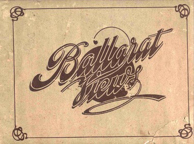
Book, Baxter & Stubbs, "Ballarat Views", 1920's
Yields information about Ballarat through pictures of the 1910-1920's various locations, institutions and street scenes, including tramways and railways.Twenty four page book within light brown covers, titled "Ballarat Views". Sheets, other than covers have been individually printed both sides, stapled within the covers. Cover - gives title, rear cover has printer details - Baxter and Stubbs. Pages 1 - Tonner Memorial , Fountain Lake Wendouree, Ballarat District Hospital, Sturt St south side at Grenville St with tram in distance and Sturt St North Side showing shops (image btm3900i2.jpg). 2 - Ballarat Street Scenes - Sturt Streets, Lydiard St with ESCo 18 in view, and Railway station with R193 in platform on passenger train. (image btm3900i3.jpg). 3 - Lake Wendouree views. 4 - Lake Wendouree, fish hatchery, Gardens and Sturt St at Dawson St (image btm3900i4.jpg). 5 - Art Gallery Ballarat 6 - Botanical Gardens 7 - Public Institution s- Benevolent asylum, Orphanage, Nazareth House, St Joseph Home, Hospital 8 & 9 - Statues, the Flight from Pompeii and others. 10 & 11 - Churches of Ballarat 12 - The Arch at The Avenue of Honour 13 - McDonald Pergola at the Gardens 14 - Zoological Gardens Ballarat 15 - Gardens aerial view and gates at the South End with tram in the distance (image btm3900i5.jpg). 16 - Some views in Ballarat East - Eureka Stockade, Ballarat East Bowling Green, Bridge St looking east and the lake at the Eureka Gardens (image btm3900i6.jpg). 17 - Snow Scene at Botanical Gardens, Begonia House 18 & 19 - Ballarat Water supply reservoirs 20 - Ballarat State Schools 21 - Ballarat East Views, includes view of track in Victoria St looking east (image btm3900i7.jpg). 22 - Views of the Water Reserves 23 - Views about the City - includes City fire station , agricultural High School, City Baths and View Point. 24 - Views at Lake Wendouree. \ Pdf copy of full book added 8/5/2019 - see btm3900i9.pdf trams, tramways, ballarat, lydiard st, sturt st, gardens, railway station, hospital, lake wendouree, wendouree parade, carlton st, esco -
 Ballarat Tramway Museum
Slide - 35mm slide/s, Glen Mills, Sept. 1971
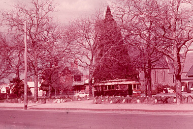
White cardboard mount, 35mm slide, from the Association of Railway Enthusiast's film strip titled "Provincial Tramway Film Strip" of Tram 12 bound for Gardens, photographed across the median strip plantation near Dawson St. with St. Peters Church in the background. The film strip notes (Reg. Item 2560), provided the following caption details: "The wide Avenue of Sturt St. was the central spine of the Ballarat system -all routes traversed it for at least part of its length. Here No. 12 "GARDENS" bound, is seen through the foliage of the centre plantation in Sturt St. -Sept. '71 (Glen Mills)" See image btm2567p.tif for high level scan of image. Stamped on base of slide "11777" and written in ink on top edge "No. 12 Sturt St Ballarat"tramways, trams, are, film strip, sturt st, st peters, tram 12 -
 Ballarat Tramway Museum
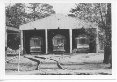
Photograph - Black & White Photograph/s - set of 8, late 1978, early 1978
Yields information the construction of the depot fan and access track to Wendouree Parade and has a strong association with the workers in the photograph.Set of eight Black and white photographs of the extensions to the tram depot and commencement of the trackwork to lay the King points, late 1978, early 1979. .1 - View from south of the level crossing showing the depot front - note the road numbers and sign at the front have been taken down. The steelwork for the depot extension has been erected. .2 - site for the King points with the track materials lay roughly out alongside . .3 - No. 27 in front of 40 on 3 road. .4 - sleepers interlaced for the King Points .5 - all the future materials laid out on the avenue - was like this for a long time .6 - King point materials looking with the mound of earth in the background. .7 - close up of the site of the King point, with the trolley in the background. .8 - rear view of the depot showing the steelwork that had erected. trams, tramways, depot construction, btps, operations, trackwork, tram 27 -
 Department of Health and Human Services
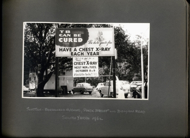
Photograph, "TB Can be Cured - Have a Chest X-Ray Each Year" promotional street signage at the junction of Birdwood Avenue, Park St and Domain Rd South Yarra 1962 - Department of Health - Tuberculosis Branch - Publicity material
-
 Melton City Libraries
Map, Streets of Melton, 1963
MELTON’S STREETS Heritage Week 2014 What’s in a Name? Alphabetical List Aboriginal place names, Early Family Names and landowners, Agricultural, Shop and Commercial premises, Places and Events Melton & District Historical Society Street Naming Project 1972 – c 1998 Suburb Name – KURUNJANG - Kirkton, 1972, Brookfield, West, 1988 Melton and Town Centre - A joint collaboration with the Shire of Melton and Subdivision Developers ARNOLD Court – Family house - Arnolds Creek ALKEMADE Drive Family – Lime kilns Coimadia ALEXANDRA Street 1902 – Corination of King Edward VII and Queen Alexandra AVIATOR Place Event, location of plane crash – Jimmy Melrose 1936 Adina ?Annibee - Anniba? Agricultural Avon court .. .. BAKERY Square - Location of Jongebloed shop, bakehouse and stables BALUK Place Aboriginal BARLEYCORN Place Agricultural BILLING Place Name of Jimmy Melrose Uncle Noel Pemberton Billing BLACKWOOD Drive - Alexander Blackwood 1860c Registrar BARRIES Road C. E. Barrie “Darlingsford” farmer 1911, chaff mill owner BROOKLYN Road Staughton family residence. 1875 – Dismantled c 193? CAHILL Drive Family - Glenville Dairy CAMERON Court Family Canopus Place ? CANALLAN Drive Early Surveyor CAMPBELL Court Aviation – Melrose passenger 6th July 1936 CARBERRY Drive Michael, early landowner family CAREW Court Edward and Michael. Royal Hotel. Vera (Carew) Forran Singer - Opera CASEY Court Family CASHIN Court Family CHEVIOT Court Agriculture, breed of sheep CHESNEY Road was re named ( Minns Road being duplicated c 1973) CHRISTINA Crescent Christina McPherson, daughter of James and Mary Mary McPherson. Died 1955 aged 85 years COLLYER Close a deleted street (parallel to Yuille) re-used CORRIEDALE Road Breed of sheep CORR Court Teacher at first school, landowner CROXTON Court Name of the Hornbuckle and Knox family home DALEY Court - William Daley and family 1865 Bootmaker High Street DARLINGSFORD Boulevard - Name of early homestead Thomas B Darling 1853 DJERRIWARRH Court - Parish County of Bourke - very early map. DODEMAIDE Place Early land owners - Melton Football Team had 6 brothers playing c 1924 DONALD Court McPherson family 6 generations in Melton in 1936 DOUGAL Court DUNCAN Court .. .. DUNVEGAN Circuit Home of the McPherson family, castle Isle of Skye Name of bluestone house Smith Street (now at Willows) EMIL Court Jongebloed family EXELL Avenue Farming family Melton Sth- Closer Settlement 1907 EXFORD Road Exe former name of the Werribee river FARMER Court Name of early postmistress FERRIS Road John Ferris Farmer HANNAH Close First name of Hannah Watts – midwife HAYBALE Place Agricultural HELDER Court Early surveyor J Helder Wedge map HEWSON Street Winston Hewson Shire Engineer – check title c 1960 HENRY Street Township map c 1860 HESTON Street Heston Phoenix – C.J. Melrose plane HILDEGARDE Court Jimmy Melrose’s mothers name HOMESTEAD Close HORNBUCKLE Cres Farmers. Three members of family - Shire Presidents HURLEY Street Farmers IAIN Court Descendent of James and Mary McPherson JAMES MELROSE Drive Name appears on 2013 Melton information map JANG Place KURUN – jang KIRKTON Drive Name of the McPherson family home Toolern Vale Road KIRWIN Street Michael early landowners (deleted for freeway construction) KILPATRICKS Road Deleted when Barries Road was extended across Station Rd KOROROIT Court Early map, Parish of Kororoit. Creek name KNOX Circuit Family – Hornbuckle “Croxton Park” KURRUNJANG Drive Aboriginal name for people of the red earth – Suburb name Lara Place ? LLOYD Court Garage owners High Street. Laura lived to 100 years D 1955 LUBY Court John Luby – Crown Grant Land Title LITTLE Court MANNING Avenue Richard, hotel owner 1891 MARGARET Drive McPherson family McDONALD Street Melton South family name McKENZIE Street Township c1860 MORROW Street Early name MOWBRAY Crescent Name of English Melton, popularly believed origin of Melton MYERS Court Early setters c 1866 Crown Grant Land Title NIMMO Street Early name NIXON Street Name submitted by Mary nee Nixon Collins c1985 OLDERSHAW Road Early builder PALMERSTON Street Early township map c 1860 PEART Court Early name PENNYROYAL Avenue Plant growing by the creek. Early name used for the Toolern Toolam Creek PINKERTON Street Family name and early street map PINNACLE Crescent Agricultural - type of wheat PHOENIX Circuit C.J. Melrose Phoenix Heston Plane 2013 map PRATT Family PRIOR Court PYKE Place Brothers – early settlement 1838 RADFORD Court Land owners and business operators. Former Royal Hotel Grocer High Street demolished 1970 RAGLAN Court Hotel 19th century Lord Raglan RALEIGHS Road Oliver Reierson family (Norweigen) Shopkeeper – Dressmakers RIDDELL Drive (misspelt Riddle) Resident and land owner RODERICK Road McPherson family – a re occurring name ROLLAND Court Jones family ROSS Court Daniel. Landowner. Agnes Ross music teacher RUSSELL Court Robert. Early land surveyor of Melton 1853 RYAN Court Family early landowner. Member of the 1862 Road Board SHEBLER Place Augustus early Melton resident – Golden Fleece Hotel SHEEPFOLD Court Farming SHERWIN Court Sherwin Street earliest Township map– became Golf course SMITH Street Early township map. STRATHULLOH Circuit Strathtulloh Homestead. STAUGHTON Street Family – LARGE land owners Strachan ? SWANEY Court Marie Swaney earlier resident of Strathtulloh. SUTHERLAND Family name TOOLERN Street TOOLAM – TOOLERN Creek TULLIDGE St Road marked on 1861 map UNITT Street Early Township c 1860 WALLACE Square Cr Jack Wallace 5 terms as President 46 years unopposed WATTS Court Hannah Watts – midwife, cottage hospital WALSINGHAM Name of house of Minns family. From Walsingham Norfolk England WESTLEY Place Name of Jimmy Melrose Percival Gull Plane WESTLAKE Drive Early resident WHICKHAM Street Family Name Melton South WILSON Road Albert, Melton South YUILLE Street William Cross, early landowner, Rockbank run Zoomed in section of Melton Streets including Church and High Streetlandscapes of significance -
 Melton City Libraries
Photograph, 'Melton South Chaff Mill employees, Unknown
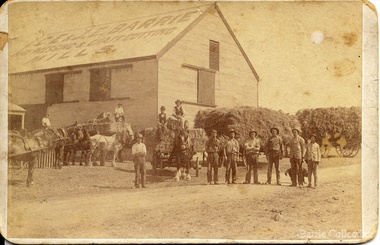
Charles E “Ernie” Barrie started constructing a Chaff mill on the corner of Brooklyn and Station road in 1900. It soon became a thriving business and was ideally located close to the railway line. Ernie and his father William and other Barrie brothers had been operated travelling chaff cutters in the district of Melton and Werribee. Within a short time the mill expanded into two big sheds in partnership with his brother James E known as “Ted”. The eldest brother William was in the Manager living in Melton South. In 1906 Ernie applied for a railway crossing on Brooklyn Road to have direct access for railway trucks to be shunted to the mill to be loaded. The Mill was also had the first phone to be connected, No 1, and No’s 2, 3 were the Golden Fleece and Macs Hotels. In 1906 Ernie married Jessie Lang daughter of the Head Teacher at Melton State School No 430 (1896 –1917). The Barrie house on the north side of the mill was completed in August 1906. It survived for almost 60 years until demolition. Chaff mills were very susceptible to fires and often burnt down and would be rebuilt again ready for the peak of the harvesting season. The final demise of the Mill occurred in a spectacular blaze on the night of Friday 2nd December 1977, just before the earth tremor as reported in the local paper. Brian Dobson the local photographer lived close by and captured the night blaze. A video was also taken of the action by the fire brigade. My parents Bon and Edna Barrie were living at 19 First Avenue, and took colour slides of the smouldering ruins in the half -light. Ironically Bon had spent the first year of his life (born in April 1909 and sister Mary born October 1907) at the house beside the mill. Trethowan’s Chaff mill in Brooklyn road was also destroyed by fire, which stated in the evening on Tuesday April 28th 1987. It was established in 1910 by Dixon Brothers, followed by, Ebbot & Kebby, Robinson, Trethowan and Butler and was with the Trethowan family when it burnt down. Melton South was small a community referred to as Melton Railway Station. Member of the community raised the idea to have a public hall. In 1909 Cr Barrie, Mr Nesbitt and Delany formed a committee to build a community hall. Cr Barrie donated the land and The Exford Hall was completed in September 1910 later to be named Victoria Hall. It was demolished in 1992. Colour slide in Barrie archive. In April 1910 the Ernie sold the Mill to Glover Onians (HSK Ward) family moved away to a property in Trundle NSW. Ernie had acquired 640 acres (a square mile) and leased a further 1920 acres of adjoining land. It was the practise of the farmers in the area at the time to buy up or lease the surrounding land from the 640 acre crown land blocks to make up acerage for a viable wheat farm. His wife Jessie found the climate to be very hot and when the Darlingsford property at Melton was put up for sale in the latter part of 1910 and was passed in at the auction. My grandfather saw this an opportunity to return to Melton. The negotiations to Darlingsford were finalised on May 11th 1911. Barrie bothers with connections to Chaff mills and farming in Melton from the 1900s William Henry, Charles Ernest, James Edwin, Samuel John, Robert, Arthur Roger, Albert Walter. Three grandsons and a great-grandson are in business earthmoving and farming in Melton today. (2013) Memoirs by Wendy BarrieEmployees at Chaff Mill, it was located on the corner of Brooklyn and Station Road, Melton South. local identities, agriculture -
 Kew Historical Society Inc
Map, MMBW, MMBW Plan No.65 Kew & Heidelberg, 1900-1910
... by Florence Avenue, in the south by Barkers Road, and in the east... Street, in the west by Florence Avenue, in the south by Barkers ...The Melbourne and Metropolitan Board of Works (MMBW) was established by an act of the Victorian Parliament in 1890 to prepare for and to implement a sewerage and water reticulation system across what was then inner Melbourne, its surrounding and middle distance suburbs, including Kew. The MMBW was disbanded in 1991.The map collection of the Kew Historical Society has at its core the historic maps assembled and originally stored in the City Engineer's Department of the City of Kew. These include maps in a number of scales. The vast majority of maps were produced by the MMBW in the first two decades of the twentieth century, and are solid working maps, backed by linen for durability. These maps are historically significant to Kew, the City of Boroondara and to the history of the development of state utilities in Victoria. A number of the Kew maps have additional details added by former municipal officers, including the levels reached by various floods. As these were working documents, information was added to them long after the period of their initial production and distribution.Early map of part of the Borough of Kew, created in the first decade of the twentieth century, at a scale 160 ft to 1 inch. The map covers what was then the south central part of Kew, bordered on its north by Malmsbury Street, in the west by Florence Avenue, in the south by Barkers Road, and in the east by Princess Street. The map shows the extent of urban development by that time, prominent institutions and the outlines of built structures in the municipality. Contour lines were added in ink to the map at a later stage.MELBOURNE AND METROPOLITAN BOARD OF WORKS / PLAN NO. 65 / KEW & HEIDELBERGmelbourne & metropolitan board of works, mmbw maps, mmbw plans, borough of kew, cartography -
 Kew Historical Society Inc
Map, MMBW, MMBW Plan No.66 Kew, 1900-1910
The Melbourne and Metropolitan Board of Works (MMBW) was established by an act of the Victorian Parliament in 1890 to prepare for and to implement a sewerage and water reticulation system across what was then inner Melbourne, its surrounding and middle distance suburbs, including Kew. The MMBW was disbanded in 1991.The map collection of the Kew Historical Society has at its core the historic maps assembled and originally stored in the City Engineer's Department of the City of Kew. These include maps in a number of scales. The vast majority of maps were produced by the MMBW in the first two decades of the twentieth century, and are solid working maps, backed by linen for durability. These maps are historically significant to Kew, the City of Boroondara and to the history of the development of state utilities in Victoria. A number of the Kew maps have additional details added by former municipal officers, including the levels reached by various floods. As these were working documents, information was added to them long after the period of their initial production and distribution.Early map of part of the Borough of Kew, created in the first decade of the twentieth century, at a scale 160 ft to 1 inch. The map covers what was then the south eastern part of Kew, bordered on its north by Adeney Avenue, in the west by Sackville Street, in the south by Barkers Road, and in the east by Burke Road. The map shows the extent of urban development by that time, prominent institutions and the outlines of built structures in the municipality. Contour lines were added in ink to the map at a later stage.MELBOURNE AND METROPOLITAN BOARD OF WORKS / PLAN NO. 66 / KEW melbourne & metropolitan board of works, mmbw maps, mmbw plans, borough of kew, cartography -
 Kew Historical Society Inc
Map, MMBW, MMBW Plan No.67 Kew, 1900-1910
The Melbourne and Metropolitan Board of Works (MMBW) was established by an act of the Victorian Parliament in 1890 to prepare for and to implement a sewerage and water reticulation system across what was then inner Melbourne, its surrounding and middle distance suburbs, including Kew. The MMBW was disbanded in 1991.The map collection of the Kew Historical Society has at its core the historic maps assembled and originally stored in the City Engineer's Department of the City of Kew. These include maps in a number of scales. The vast majority of maps were produced by the MMBW in the first two decades of the twentieth century, and are solid working maps, backed by linen for durability. These maps are historically significant to Kew, the City of Boroondara and to the history of the development of state utilities in Victoria. A number of the Kew maps have additional details added by former municipal officers, including the levels reached by various floods. As these were working documents, information was added to them long after the period of their initial production and distribution.Early map of part of the Borough of Kew, created in the first decade of the twentieth century, at a scale 160 ft to 1 inch. The map covers what was then the north central part of Kew, bordered on its north by the Outer Circle Railway Spruzen and Beresford Avenues, in the west by Princess Street, in the south by High Street, and in the east by (about) Belford Road. The map shows the extent of urban development by that time, prominent institutions and the outlines of built structures in the municipality. Contour lines were added in ink to the map at a later stage.MELBOURNE AND METROPOLITAN BOARD OF WORKS / PLAN NO. 67 / KEW melbourne & metropolitan board of works, mmbw maps, mmbw plans, borough of kew, cartography -
 Kew Historical Society Inc
Map, MMBW, MMBW Plan No.68 Kew, 1900-1910
The Melbourne and Metropolitan Board of Works (MMBW) was established by an act of the Victorian Parliament in 1890 to prepare for and to implement a sewerage and water reticulation system across what was then inner Melbourne, its surrounding and middle distance suburbs, including Kew. The MMBW was disbanded in 1991.The map collection of the Kew Historical Society has at its core the historic maps assembled and originally stored in the City Engineer's Department of the City of Kew. These include maps in a number of scales. The vast majority of maps were produced by the MMBW in the first two decades of the twentieth century, and are solid working maps, backed by linen for durability. These maps are historically significant to Kew, the City of Boroondara and to the history of the development of state utilities in Victoria. A number of the Kew maps have additional details added by former municipal officers, including the levels reached by various floods. As these were working documents, information was added to them long after the period of their initial production and distribution.Early map of part of the Borough of Kew, created in the first decade of the twentieth century, at a scale 160 ft to 1 inch. The map covers what was then the north central part of Kew, bordered in the north by Oak Avenue, in the west by the Yarra River and Connor's Creek, in the south by Beresford and Carnegie Avenues, and in the east by Glass's Creek and Burke Road. The map shows the extent of urban development by that time, prominent institutions and the outlines of built structures in the municipality. Contour lines and the levels of historic floods were added in ink to the map at a later stage.MELBOURNE AND METROPOLITAN BOARD OF WORKS / PLAN NO. 68 / KEW melbourne & metropolitan board of works, mmbw maps, mmbw plans, borough of kew, cartography -
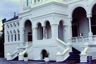 Kew Historical Society Inc
Slide - 'Burke Hall', Nolan Avenue, 1976
Colour transparency (slide) created in June 1976 during a tour by the Junior National Trust, which was led by members of Kew Historical Society. The collection of 21 slides reveals that the tour covered all parts of Kew, but focused understandably on heritage buildings and sites.Image of an historic place in Kew that can be dated to an exact time and place. The images, albeit amateurish in composition, frequently reveal aspects of important buildings and sites that have changed over time.35mm colour transparency of the front portico of Burke Hall (formerly Studley Hall, Waverley) and now Xavier Junior School in Nolan Avenue, Kew. Since its construction in the 19th century, the building has had numerous additions made by subsequent owners. The original render has been painted and sections of the original colonnades glazed in. The facade of Burke Hall faces away from Studley Park Road to take advantage of the views to the south.historic houses -- kew (vic), xavier college -- kew (vic.), burke hall -- kew (vic.), waverley -- kew (vic.), nolan avenue -- kew (vic.), studley hall -- kew (vic.) -
 Kew Historical Society Inc
Photograph - High Street, Kew, 1960-65
The borders of the main components of Kew and Kew East have not always conformed to current boundaries. In the past this photograph has been labelled as East Kew, whereas for most of the twentieth century the site has been within Kew's borders. The purpose of the photograph is unrecorded yet it has value in that it shows those businesses who occupied this site in Kew during the early 1960s.This small photograph is significant as it shows the location of and building used by WD Vaughan, former Mayor of Kew who was a successful newspaper proprietor in Melbourne.Small polaroid colour positive of High Street in Kew, probably in the 1960s. From left we can see the brick viaduct covering the tracks of what was once the Outer Circle Railway. Behind this brick wall, Dunnings Timber Yard was situated. At the end of the walls of the viaduct there is an entrance to a walkway [now the Anniversary Trail], which once provided access to Windsor Avenue, and also to the East Kew Station (now demolished and part of the Outer Circle Railway Reserve). On the other side of this walkway is a cream brick building (demolished) occupied at this time by WD Vaughan Pty Ltd, printer and publisher of the Kew Advertiser (newspaper). Stretching behind the brick facade is an extensive building that must have housed the printing works. Beside Vaughan's, there is a large building (demolished) housing at that time an estate agent named AJ Kennedy. This area is now separated by kerbing.High St East Kew / Corner of Harp Rd. / Looking South -
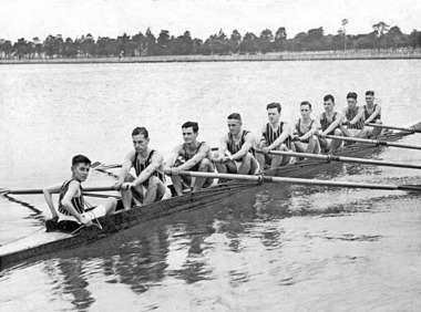
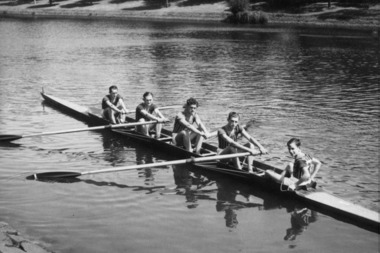
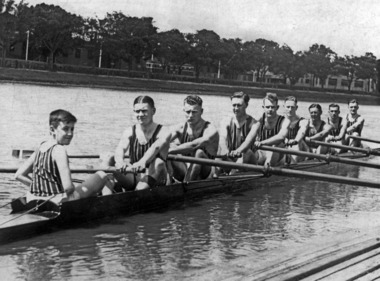 Power House Rowing Club
Black and white photograph, PHRC Maiden VIII Henley Regatta, 1933
... Power House Rowing Club 164 Alexandra Avenue South Yarra ...Digital scan of black and white photograph. J Barton Jr (cox) H Rutter (Str) P Hiddlestone (7) R Luff (6) R Manser (5) J Ramsbottom (4) W Wakeham (3) W Tutt (2) V Muller (Bow) J Barton Senr (Coach)rowing, rowers, sweep rowing, men, river, riverbank, sportsmen, sports -
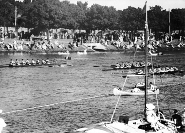
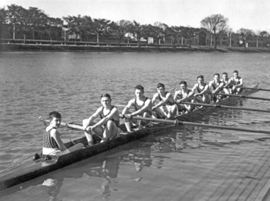
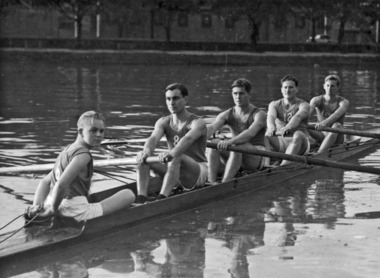
 Power House Rowing Club
Black and white photograph, Maiden VIII, 1935
... Power House Rowing Club 164 Alexandra Avenue South Yarra ...Digital scan of black and white photograph.J Barton (Coach) H Rutter (Str) R Luff (7) L Orr (6) F Hiddlestone (5) J Glover (4) Not recorded (3) J Fuller (2) V Muller (Bow) -
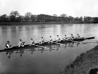
 Power House Rowing Club
Black and white photograph, PHRC Maiden VIII Henley win, 1935
... Power House Rowing Club 164 Alexandra Avenue South Yarra ...Digital scan of black and white photograph. Names not recorded.rowing, rowers, river, riverbank, spectators, boats -
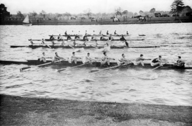
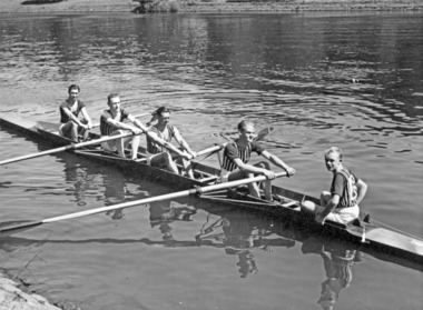
 Power House Rowing Club
Black and white photograph, PHRC Maiden VIII Henley, 1935
... Power House Rowing Club 164 Alexandra Avenue South Yarra ...Digital scan of black and white photograph. J Barton Jnr (cox) H Rutter (Str) F Huddlestone (7) R Luff (6) R Manser (5) W Ramsbottom (4) W Wakeham (3) W Tatt (2) V Muller (Bow) J Barton Snr (Coach)rowers, rowing, sportsmen, men, river, riverbank, sports, row -
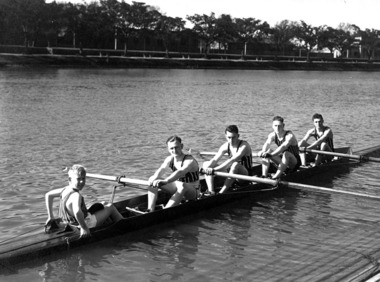
 Power House Rowing Club
Black and white photograph, The Sears Studio St Kilda, PHRC Novice VIII, 1936
... Power House Rowing Club 164 Alexandra Avenue South Yarra ...Digital scan of framed black and white photograph.J Barton Jnr (cox) I Scales (Str) N West (&) J Chadwick (6) J Fuller (5) D Stewart (4) L Orr (3) D Garside (2) E Campbell (Bow) J Barton Snr (Coach) -
 Power House Rowing Club
Black and white photograph, PHRC crew practice 4, 1937
... Power House Rowing Club 164 Alexandra Avenue South Yarra ...Digital scan of black and white photograph. Names not recorded.rowers, rowing, row, sports, sportsmen, river, riverbank -
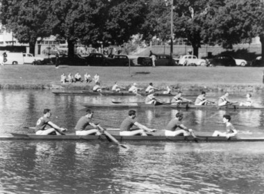
 Power House Rowing Club
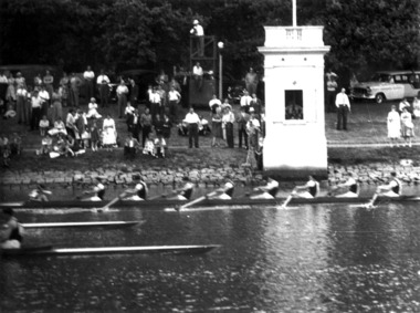
Black and white photograph, Head of the Lake, 1938
... Power House Rowing Club 164 Alexandra Avenue South Yarra ...Digital scan of black and white photograph. Names not recorded.rowing, rowers, lake, sports, sportsmen -
 Power House Rowing Club
Black and white photograph, PHRC crew racing 4, 1938
... Power House Rowing Club 164 Alexandra Avenue South Yarra ...Digital scan of black and white photograph. Names not recorded. -
 Power House Rowing Club
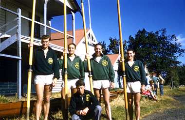
Maiden IV Winner MRA regatta, 1938
... Power House Rowing Club 164 Alexandra Avenue South Yarra ...Digital scan of black and white photograph.POWER HOUSE MAIDEN IV - WINNERS MURRAY ROWING ASSOCIATION REGATTA 1938 C BARNES (BOW) J COWLEY (2) A GEYTON (3) E ISRAEL (STR) J GATES (COX) R KEON-COHEN (COACH) -
 Power House Rowing Club
Black and white photograph, PHRC Winners Army Service Regatta, 1939
... Power House Rowing Club 164 Alexandra Avenue South Yarra ...Digital scan of black and white photograph. Names not recorded. -
 Power House Rowing Club
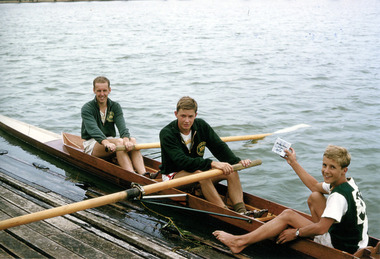
Black and white photograph, PHRC Maiden IV Winner VRA regatta, 1939
... Power House Rowing Club 164 Alexandra Avenue South Yarra ...Digital scan of black and white photograph.WINNERS MAIDEN FOUR. V.R.A. REGATTA. 30TH JAN.,1939. V. Muller, W. Pollock, J. Fuller, D. Fisher, A. Beattie (Cox) Coach Russel – Keon-Cohen -
 Power House Rowing Club
Black and white photograph, 02 PHRC Novice IV UY Regatta, 1957
... Power House Rowing Club 164 Alexandra Avenue South Yarra ...Digital scan of black and white photograph. -
 Power House Rowing Club
Black and white photograph, 02 Maiden VIII, 1958
... Power House Rowing Club 164 Alexandra Avenue South Yarra ...Digital scan of black and white photograph. Names not recorded. -
 Power House Rowing Club
Colour photograph, 03 Albert Park Novice IV, 1959
... Power House Rowing Club 164 Alexandra Avenue South Yarra ...Digital scan of colour photograph. Names not recorded. -
 Power House Rowing Club
Colour photograph, 08 Albert Park Maiden II, 1960
... Power House Rowing Club 164 Alexandra Avenue South Yarra ...Digital scan of colour photograph. Names not recorded.