Showing 409 items matching "south court"
-
 Federation University Historical Collection
Photograph - Sepia, Photopress, St Hilda's Band, 1930's?
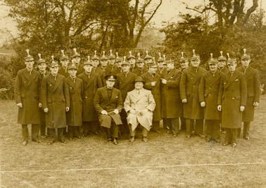
Frank Wright was a renown resident of Smeaton, where he was born. He lived at Laura Villa, and attended Smeaton State School. His father William was a gold miner and his mother's name was Sarah. Their family won many singing and instrumental awards. Frank was tutored by Percy Code and was awarded a gold medal for the highest marks in the ALCM examinations in the British Colonies at the age of seventeen years. He became the Australian Open Cornet Champion by the age of eighteen. A year later, Frank conducted the City of Ballarat Band, and later the Ballarat Soldiers’ Memorial Band. He formed the Frank Wright Frisco Band and Frank Wright and his Coliseum Orchestra. These bands won many South Street awards, and Frank as conductor won many awards in the Australian Band Championship contest. In 1933 Frank Wright sailed to England to conduct the famous St Hilda’s Band and was later appointed Musical Director of the London County Council, where he organized many amazing concerts in parks, in and around the London district. He was made Professor of Brass and Military Band Scoring and conducted at the Guildhall of Music and Drama. Frank was often invited to adjudicate Brass Band Championships around Europe, in Australia, including South Street and in New Zealand. The Frank Wright Medal at the Royal South Street competition is awarded to an individual recognized as making an outstanding contribution to brass music in Australia.Sepia photograph of the members of a brass band dressed in their winter coats standing in a park with trees in the background. The conductor and another man are seated in the foreground. The conductor is Frank Wright and the band is St. Hilda's Band of London.Stamped on back - Photo supplied by Photopress, Johnson's Court, Fleet Street, London BC.4, Phone Central 5335frank wright, cornet, conductor, ballarat, st hilda's band, london -
 Federation University Historical Collection
Photograph - Black and White, Photopress, St Hilda's Band, 1920's
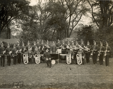
Frank Wright was a renown resident of Smeaton, where he was born. He lived at Laura Villa, and attended Smeaton State School. His father William was a gold miner and his mother's name was Sarah. Their family won many singing and instrumental awards. Frank was tutored by Percy Code and was awarded a gold medal for the highest marks in the ALCM examinations in the British Colonies at the age of seventeen years. He became the Australian Open Cornet Champion by the age of eighteen. A year later, Frank conducted the City of Ballarat Band, and later the Ballarat Soldiers’ Memorial Band. He formed the Frank Wright Frisco Band and Frank Wright and his Coliseum Orchestra. These bands won many South Street awards, and Frank as conductor won many awards in the Australian Band Championship contest. In 1933 Frank Wright sailed to England to conduct the famous St Hilda’s Band and was later appointed Musical Director of the London County Council, where he organized many amazing concerts in parks, in and around the London district. He was made Professor of Brass and Military Band Scoring and conducted at the Guildhall of Music and Drama. Frank was often invited to adjudicate Brass Band Championships around Europe, in Australia, including South Street and in New Zealand. The Frank Wright Medal at the Royal South Street competition is awarded to an individual recognized as making an outstanding contribution to brass music in Australia.Black and white photograph of a brass band standing with their instruments in a park with trees in the background. The conductor and the four bassoon players are seated. The conductor is Frank Wright and the band is St. Hilda's Band of London.Stamped on back - Copyright photograph by Photopress, Johnson's Court, Fleet Street, BC.4, Phone: Central 5335-6, Not to be reproduced or copied without our official permission.frank wright, cornet, conductor, ballarat, st hilda's band, london -
 Federation University Historical Collection
Photograph - Photograph - Digital, Geoff Little, Ballarat Gaol Under Demolition, 1968, 1968
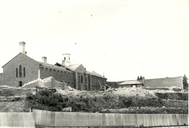
The Ballarat Gaol was one of the earliest gaols. Building commenced in 1856 and was completed in 1862. It provided accommodation for 74 prisoners - male and female. The materials use to build the gaol were locally quarried basalt combined with local bricks. At that time there were about 14 brick making plants in Ballarat. 1870 saw the opening of the School of Mines, Australia's third oldest tertiary institution. The purpose of the school was "to impart instruction in the various branches of science relating to mining engineering. It is proposed, as soon as practicable, to extend the operation of the school so as to impart instruction in those branches of technical science which may be considered most likely to exert a beneficial influence on the prosperity of Victoria." School was in a disused Circuit Court House in Lydiard Street South. Sir Redmond Barry was first President of the School of Mines Council.Seven black and white and sepia photographs of the Ballarat Gaol under demolition. Progressive demolition showing rubble and machinery used. Gift of photographer. ballarat gaol, ballarat school of mines, gaol, basalt, local bricks, prisoners, circuit court house, mining engineering, sir redmond barry, lydiard street, tertiary institution, geoff little -
 Federation University Historical Collection
Photograph - Photograph - Black and White, Former Ballarat Gaol, c1861, c1861
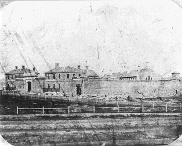
The former Ballarat Gaol was commenced in 1856 and completed in 1862, This view looks up Lydiard Street South, and was taken before the Ballarat Courthouse was built south of the gaol in 1868. The wall was built from quarried basalt with local bricks. A system of burning the lime mortar between the joints and the shape of the wall meant it had a high degree of stability. From 1870 on more buildings were constructed and these became the School of Mines and Industries Ballarat. The Gaol closed in 1965. This image shows the Ballarat Gaol c. 1861 giving us an understanding of what the site looked like before all the changes that have occurred over the years since the gaol closed and other organisations have had the site. Black and white image showing the former Ballarat Gaol from Lydiard Street South.Label on underneath photograph: The Ballarat Gaol, c.1861 - This view looks up Lydiard Street towards our present school entrance. The gaol buildings remain unchanged . Note that the Court House, now S.M.B's Elec. classrooms, has not yet been built on the right hand side of the gaol.ballarat gaol, ballarat school of mines, gaol, m113, lydiard street, courthouse, lime mortar, lydiard street south -
 Federation University Historical Collection
Image, Ballarat School of Mines former Court House and Chemistry Laboratory, 1882
The Ballarat School of Mines was Australia's first, and was established in 1870. The former Ballarat Circuit Court was the first site of the Ballarat School of Mines. This building was demolished to make way for the Ballarat Technical Art School which was opened in 1915. Image of the Ballarat School of Mines, Lydiard Street in 1882. It shows the first building (former Circuit Courthouse), and the Chemistry Buildings. The lower chimney is a gauge tower designed by Henry Richards Caselliballarat school of mines, establishment, former ballarat circuit courthouse, gauge tower, mining, henry caselli, lydiard street south -
 Federation University Historical Collection
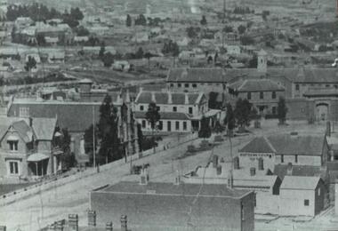
Photograph, Ballarat Looking Towards the Wesleyan Church
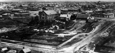
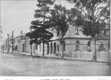
Panoramic view of Lydiard Street South in Ballarat from the intersection of Lydiard Street and Dana Street. The view shows the former Ballarat Supreme Court (later the Ballarat School of Mines), the Lydiard Street Wesleyan Church (later the Ballarat School of Mines Museum), the site of the Ballarat School of Mines Botanical Gardens, George Smith's Nursery, Ballarat Gaol. Details of the image are also depicted.ballarat school of mines, ballarat gaol, ballarat school of mines museum, ballarat school of mines botanical gardens, george smith, museum, ballarat wesleyan church, ballarat methodist church, lydiard street wesleyan church, c.smith nursery -
 Federation University Historical Collection
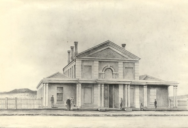
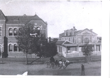
Photograph - Photograph - Black and white, Circuit Court House Ballarat - 1859
... Black and white photograph of the Circuit Court House... photograph of the Circuit Court House, Lydiard Street South Ballarat ...The Circuit Court House buildings were located in Lydiard Street Ballarat. By 1862 the Ballarat Gaol was completed, including a tunnel connecting the Gaol to the Court House. The original initiative for the founding of the Ballarat School of Mines was taken at a meeting of the Ballarat Mining Board on 6 October 1869. The Provisional Ballarat School of Mines Council applied to the Government for the lease of the former Circuit Court House. It was approved for a 15 year period at one shilling per annum. The official opening of the Ballarat School of Mines by its first President, Sir Redmond Barry, was held 26 October 1870 in the former Circuit Court House, Lydiard Street Ballarat. Conversions were made to accommodate the new role it was to play. On 14 December 1912, demolition of the former Circuit Court House commenced. In 1915, Ballarat Technical Art School opened on the site of the former Circuit Court House. Black and white photograph of the Circuit Court House, Lydiard Street South Ballarat. Brick building with veranda across the front. This is supported by 5 groups of columns. Main section is two storey with single storey wing on either side. Arched window in centre of top storey, directly above double doorway. Features pillar effect in brick/stone across the front.ballarat school of mines, ballarat court house, ballarat circuit court house, lydiard street ballarat, sir redmond barry, ballarat mining board, government, ballarat technical art school, 1912, 1915, lydiard street south -
 Federation University Historical Collection
Plans, Plans of the Ballarat School of Mines, Lydiard Street South, Ballarat, 1953
.3) Ballarat School of Mines plan for water supply installation to prefabricated classrooms associated with the Ballarat Girls' Techncial School, April 1953 .4) Ballarat School of Mines plans for three prefabricated classrooms to be used as the Ballarat Girls' Techncial School, Hickman Street, Ballarat by Percy E. Everett, 16 December 1952. Earthworks undertaken by T.G. James. .5) Ballarat Sewerage Authority Plan of Drainage Prefabricated Class Rooms Ballarat School of Mines by Chief Architect Percy E. Everett, 13 April 1953. The plan shows basket ball court and shelter, classrooms, contours, excavations and girls toilet associated with the Ballarat Girls' Techncial School, Hickman Street, Ballarat. ballarat junior girls' technical school, ballarat girls' technical school, ballarat school of mines, hickman street, white flat, t.g. james -
 Federation University Historical Collection
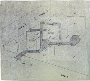
Plan, Plan for a Service Plan at the Ballarat School of Mines
This plan appears to show buildings that were not built. Plkan showing the section of the Federation University SMB Campus between Grant Street and Lydiard Street, near Armstrong Street South.smb campus, ballarat school of mines, grant street, lydiard street, former ballarat supreme court -
 Federation University Historical Collection
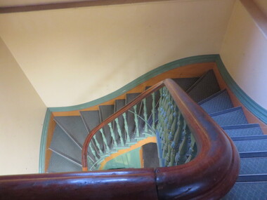
Photograph - Colour, Clare Gervasoni, Ballarat School of Mines Theatre (former Ballarat Supreme Court), 2016, 2016
... and views through windows taken in the former Ballarat Supreme Court... supreme court staircase armstrong street south A number ...A number of photographs showing interiors, exteriors and views through windows taken in the former Ballarat Supreme Court (Lydiard Street South) now the Federation University SMB Campus Performing Arts Theatre.ballarat school of mines, theatre, perfroming arts, former ballarat supreme court, staircase, armstrong street south -
 Federation University Historical Collection
Document, Frank Wright, Speech Notes by Frank Wright, 8 July 1970, 8 July 1970
Frank Wright was a renown resident of Smeaton, where he was born on 2 August 1901. He lived at Laura Villa, and attended Smeaton State School. His father William was a gold miner and his mother's name was Sarah. Their family won many singing and instrumental awards. Frank was tutored by Percy Code and was awarded a gold medal for the highest marks in the ALCM examinations in the British Colonies at the age of seventeen years. He became the Australian Open Cornet Champion by the age of eighteen. A year later, Frank conducted the City of Ballarat Band, and later the Ballarat Soldiers’ Memorial Band. He formed the Frank Wright Frisco Band and Frank Wright and his Coliseum Orchestra. These bands won many South Street awards, and Frank as conductor won many awards in the Australian Band Championship contest. In 1933 Frank Wright sailed to England to conduct the famous St Hilda’s Band and was later appointed Musical Director of the London County Council, where he organized many amazing concerts in parks, in and around the London district. He was made Professor of Brass and Military Band Scoring and conducted at the Guildhall of Music and Drama. Frank was often invited to adjudicate Brass Band Championships around Europe, in Australia, including South Street and in New Zealand. The Frank Wright Medal at the Royal South Street competition is awarded to an individual recognized as making an outstanding contribution to brass music in Australia.4 pages of handwritten notes by Frank Wright. Page 1 contains a 'Speech of welcome to Joan Hammond when she was resented with the Sir Charles Santley Award by the Worshipful Company of Musicians' on 8 July 1970. The final three pages are a report by Frank as the Chairman of the Committee to the Court of the Worshipful Company of Musicians at the same meeting.All handwritten notes.frank wright, speech notes, joan hammond, worshipful company of musicians, composer, conductor -
 Federation University Historical Collection
Photograph - Image - black and white, Former Ballarat Gaol and Supreme Court, Lydiard Street South, Ballarat
... Former Ballarat Gaol and Supreme Court, Lydiard Street... ballarat gaol ballarat supreme court lydiard street south Black ...Black and white photographic image of Lydiard Street South showing the former Ballarat Supreme COurt and the former Ballarat Gaolballarat gaol, ballarat supreme court, lydiard street south -
 Federation University Historical Collection
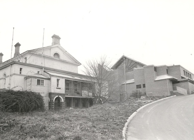
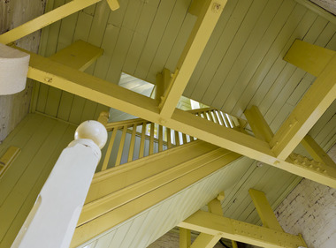
Black and white photograph, Rear view of the former Ballarat Supreme Court, Lydiard Street South, c2004
... Rear view of the former Ballarat Supreme Court, Lydiard... of the former Ballarat Supreme Court, Lydiard Street South. Black ...Black and white photograph of the rear of the former Supreme Court. Built in 1868 as part of the Ballarat Gaol complex, it became part of the Ballarat School of Mines in 1947 and used for Electrical Engineering. It has now been transformed into a performing arts centre. New building shown is Amenities Building and was officially opened in 1981. Radiating beams used for the top window are made from Oregon wood. Thought to be the last building using this wood for this purpose. Drive up to the building comes off Grant Street. All this is part of Federation University - Grant Street Campus.Black and white photograph of the rear of the former Courthouse. Built in 1868, it became part of the Ballarat School of Mines in 1947. New building shown is the Amenities Building. All part of Federation University - Grant Street Campus.ballarat supreme court, ballarat gaol, ballarat school of mines, electrical engineering, performing arts centre, amenities building, oregon cedar, grant street, grant street, federation university -
 Federation University Historical Collection
Photograph - black and white, Frank Wright Playing Tennis, 10/1928
Frank Wright was a renown resident of Smeaton, where he was born. He lived at Laura Villa, and attended Smeaton State School. His father William was a gold miner and his mother's name was Sarah. Their family won many singing and instrumental awards. Frank was tutored by Percy Code and was awarded a gold medal for the highest marks in the ALCM examinations in the British Colonies at the age of seventeen years. He became the Australian Open Cornet Champion by the age of eighteen. A year later, Frank conducted the City of Ballarat Band, and later the Ballarat Soldiers’ Memorial Band. He formed the Frank Wright Frisco Band and Frank Wright and his Coliseum Orchestra. These bands won many South Street awards, and Frank as conductor won many awards in the Australian Band Championship contest. In 1933 Frank Wright sailed to England to conduct the famous St Hilda’s Band and was later appointed Musical Director of the London County Council, where he organized many amazing concerts in parks, in and around the London district. He was made Professor of Brass and Military Band Scoring and conducted at the Guildhall of Music and Drama. Frank was often invited to adjudicate Brass Band Championships around Europe, in Australia, including South Street and in New Zealand. The Frank Wright Medal at the Royal South Street competition is awarded to an individual recognized as making an outstanding contribution to brass music in Australia.1). Black and white photograph of a man dressed in light coloured trousers and a white short sleeve shirt, serving a tennis ball. Situated on a tennis court with buildings in the background. The man is Frank Wright. 2). Black and white photograph of a young man dressed in tennis whites and a jacket, holding a tennis racquet and leaning against the net on a tennis court. In the background is a hedge topped timber fence with the roof of a house behind. The man is perhaps Frank Wright or a friend.frank wright, conductor, tennis, tennis racquet -
 Federation University Historical Collection
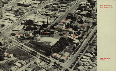
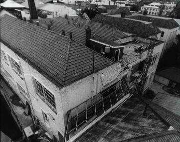
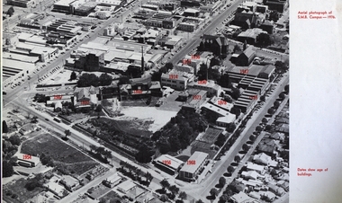
Photograph - Image, Aerial Image of the Ballarat School of Mines, 1976, 1976
Black and white aerial Image of the Ballarat School of Mines, with the date of the construction of each building indicated in red. The image shows the site after the Ballarat Gaol and the Ballarat Brass Works (M.B. John) buildings have been demolished. It includes the former Battery Building, tennis court which were demolished to make way for the M.B. John Building on Albert Street. It also shows the former Ballarat Girls' Technical School.former ballarat gaol, former ballarat brass works, m.b. john building, battery building, tennis court, albert street, grant street, lydiard street south, armstrong street south, ballarat girls' technical school. -
 Federation University Historical Collection
Photograph - Photographs - black and white, Ballarat School of Mines: Lydiard Street Campus Buildings, early 1900s, c1978
These photographs were taken just before structural modifications and connecting overhead walkways were commenced in 1978.1: Art School opened in 1915 on the site of the original SMB building.It was converted from the abandoned court house. Also Administration building including the teaching and other spaces. .2: "Old Chemistry building" showing the south side and west end. .3: Art school on the left, Ballarat Brewery boiler chimney stack in centre background, Administration building on the right. .4: Entrance on the north side of Art School building .5: South side entrance of Administration building.ballarat school of mines, buildings, a building, administration building, lydiard street south, smb campus -
 Federation University Historical Collection
Photograph - Photograph - Black and White, N.L. Harvey & Sons Photographers, Ballarat School of Mines Aerial View
The Ballarat School of Mines Campus is a campus of Federation University Australia.Aerial view of the Ballarat School of Mines campus from the Grant Stret/Eyre Street corner. The photograph was taken after the demolition of the gaol and before the E.J. Tippett Library and Hillman Recreation Reserve were built. The Ballarat Girls' Technical School is present in Grant Street, and in sthe Ballarat SChool of Mines Mining Laboratory in Albert Street. The Ballarat Brewery (then Carton and United Breweries) is present in Lydiard Street South.aerial, ballarat school of mines, ballarat gaol, ballarat school of mines tennis court, grant street, ballarat girls' junior technical school -
 Federation University Historical Collection
Photograph - Photograph - Black and White, School of Mines Ballarat; c1910, c1910
... administration building new classrooms ballarat circuit court house ...The former Ballarat Circuit Courthouse was used as the first site of the Ballarat School of Mines in 1870.Black and white photograph of two buildings at the Ballarat School of Mines. The one on the right is the former Ballarat Circuit Court House which was demolished to make way for the Ballarat Technical Art School (Gribble Building). The building on the left was orginally known as the New Classrooms and were opened in 1901. It is now known as the Administration Building (A-Building).ballarat school of mines, administration building, new classrooms, ballarat circuit court house, lydiard street south -
 Federation University Historical Collection
Photograph - Photograph - Sepia, Former Ballarat Gaol and Circuit Court House, c1895, c1900
... court house wesley church supreme court hotel lydiard street ...Photograph of the Ballarat school of Mines (Former Circuit Courthouse), Ballarat Gaol and Wesley Church (later Ballarat School of Mines Museum).ballarat, ballarat school of mines, ballarat gaol, ballarat circuit court house, wesley church, supreme court hotel, lydiard street south -
 Federation University Historical Collection
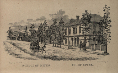
Image, Ballarat School of Mines and Ballarat Court House
Line image of the Ballarat Supreme Court House and the Ballarat School of Mines in Lydiard Street South, Ballarat.ballarat school of mines, ballarat supreme court house, ballarat court house, lydiard street, ballarat buildings, lydiard street south, ballarat -
 Federation University Historical Collection
Image, Ballarat School of Mines Aerial View with Dates of Buildings, 1976
Aerial photograph of the Ballarat School of Mines, with establishment date for each building. ballarat school of mines, aerial, buildings, former ballarat gaol, mining laboratory, hillman hall, former supreme court, administration building, ballarat technical art school, former wesley church, ballarat girls technical school, ballarat junior technical school, albert street, grant street, lydiard street south, armstrong street south, dana street -
 Federation University Historical Collection
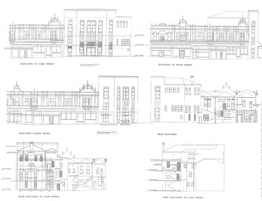
Plans, University of Ballarat Arts Academy Plans, c2000
Copies of the plans for the University of Ballarat Arts Academy, Camp Street, Ballarat.new north building, new south building, mining exchange, ballarat post office, former ballarat court house, former ballarat library -
 Federation University Historical Collection
Photographs - Colour, Trav Munro, Federation University Camp Street Campus, 2016, 2016
... Ballarat Post Office (now Post Office Gallery), Former Law Courts... office former ballarat law courts former ballarat state offices ...Colour photographs by Trav Munro of buildings at the Federation University Camp Street Campus, including the former Ballarat Post Office (now Post Office Gallery), Former Law Courts (State Offices), New South, New Northtrav munro, federation university australia, camp street, arts academy, post office gallery, post office gallery, former ballarat post office, former ballarat law courts, former ballarat state offices, new north, new south, old sheriff's office -
 City of Moorabbin Historical Society (Operating the Box Cottage Museum)
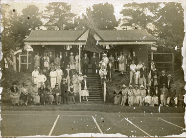
Photograph, black & white Cheltenham Tennis Club 1920, and 2 Documents, 1920
Cheltenham Tennis Club was established 1883 when Shire of Moorabbin released land in Cheltenham Park for recreational use. 1924 The Shire of Moorabbin gave permission for the development of extra Courts.Cheltenham Tennis Club 1883 was one of the first Tennis Clubs established in Melbourne.A black and white photograph of men and women seated and standing in and around the Cheltenham Tennis Clubhouse in Cheltenham Park, Cheltenham in 1920. Letter Handwritten 1883 Shire of Moorabbin, South Brighton , release of land in Cheltenham Park for the development of Tennis Courts. Letter Typed 1924 Shire of Moorabbin, permission for extra Courts, signed by the shire secretary, Alexander Chalmers Smith.PHOTO ; written on back : Cheltenham Tennis Club 1920 / Cheltenham Park Letter ; signed John Keys Shire of Moorabbin South Brighton Logo 1871 Letter ; Shire of Moorabbin Logo 1924charman road, cheltenham, 1920, tennis club. charman stephen, gettens mary, spring grove, charman road, balcombe road, nepean road, dairy farmers, market agrdeners, poultry farmers, methodist church, keys john, shire of moorabbin, colsamix, cheltenham park melbourne, sabbath victorian law article 26, cheltenham golf club -
 City of Moorabbin Historical Society (Operating the Box Cottage Museum)
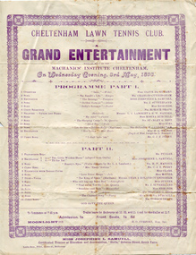
Programme - Cheltenham Lawn Tennis Club, Grand Entertainment, 1893
Cheltenham Lawn Tennis Club was established in 1883, which was situated in the Cheltenham Park Reserve, described in its time as one of the most commanding and beautiful spots south of Melbourne. The program of a nights "Grand Entertainment" by the Cheltenham Lawn Tennis Club, held in the Mechanics Institute Cheltenham on Wednesday Evening, 3rd May 1893. Instructions for resurfacing the tennis court with colasmix and the cost associated with it. Cheltenham Lawn Tennis Club had its courts resurfaced for the Jubilee in 1887.Cheltenham Tennis Club 1883 was one of the first Tennis Clubs established in Melbourne.A Programme on a single sheet that lists the entertainment for the evening. Instruction for using Colasmix on tennis Courts and associated costs - three pages.tennis, entertainment, cheltenham lawn tennis club, cheltenham mechanics institute, charman road, cheltenham, 1920, keys john, shire of moorabbin, cheltenham park melbourne, colasmix -
 Bendigo Historical Society Inc.
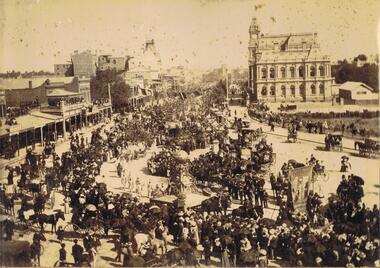
Photograph - PALL MALL LOOKING SOUTH
Photo album, cover has blue cover, maroon spine, spine disconnected from pages. 'Album' on front. Sepia photograph stuck inside front cover of album. Image shows large procession heading north up Pall Mall. On RH side of image: Law Courts, Union Jack flag flying overhead. Conservatory Gardens just visible, palm trees not evident, picket fence along footpath. In centre of image: procession with horse drawn floats; float in front of image has large gold coloured ball above an ornate supporting structure. Written on side of ball ' Gold .tained…' (gold contained?) On LH side of image, 'Harry Davey’ and 'F. Davey' written on shop fronts. All shops along Pall Mall have verandahs. Many people are sitting on balconies and rooftops watching the parade. Appears to be approx. 1890’s?bendigo, streetscape, pall mall, bendigo, sandhurst, procession, gold, post office, pall mall -
 Bendigo Historical Society Inc.
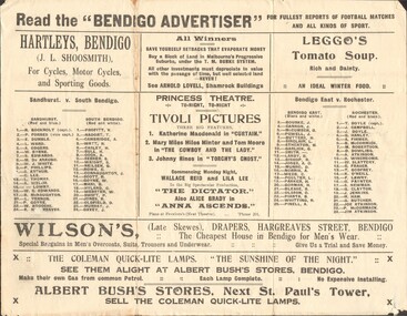
Newspaper - RANDALL COLLECTION: THE BENDIGO ADVERTISER FOR FULLEST REPORTS OF FOOTBALL MATCHES, 1923
Newspaper, The Bendigo Advertiser for fullest reports of Football matches and all kinds of sport.Hartleys, Bendigo; Arnold Lovell , Shamrock Buildings; Leggo's Tomato Soup; Princess Theatre; Wilson's Drapers, Hargreaves St, Bendigo;Albert Bush's Stores, Bendigo; Sandhurst V. South Bendigo; Bendigo East V. Rochester; T.E.Turner, The Electrical Shop; J..Friswell , Bendigo's Leading Butcher; Shamrock Tobacco Store; H.R.Hughan's View point News Agent; Les Pascoe Saddler Hargreaves St.; Cambridge Press; After the Match have a pasty at Percy Smith's Opposite Law Courts. Bendigo Football Premiership Records from 1880 to 1922.newspaper, bendigo advertiser, football records -
 Bendigo Historical Society Inc.
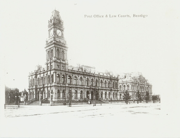
Photograph - POST OFFICE AND LAW COURTS, c1906
Black and white photocopy. Public buildings Pall Mall, Post Office, Law Courts looking NNE. Original taken c1906 by WH Robinson, Tran in foreground. Two horse drawn carriages. Four pedestrians on footpath. South African War Memorial on left hand foreground. Photograph most likely taken on a Sunday afternoon, because of the lack of traffic. Inscriptions: Post Office and public buildings, Bendigo (printed) History of photograph. First appears? In a 1906 publication by Bolton Bros.WH Robinsonbuildings, government, bendigo post office -
 Bendigo Historical Society Inc.
Photograph - MITCHELL STREET: BENDIGO, 1995
Black and white photograph: looking up Mitchell Street, Bendigo to the south. Photo taken from Charing Cross with the Bendigo Building Society Fountain Court Building on the immediate right. On back of photo in grey lead pencil B14. Noelene Wild 7/2000 ' photo Peter Hyett, 1995, Mitchell St. from Charing Cross.Peter Hyettplace, streetscape, mitchell street, bendigo -
 Bendigo Historical Society Inc.
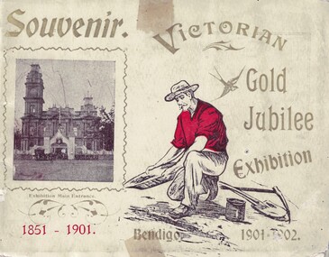
Souvenir - Views of Bendigo, 1902
The Victorian Gold Jubilee Exhibition, held at Bendigo from 13 November 1901 to 14 May 1902. The courts were numbered from one, or had titles like “Machinery”, “Agricultural”, “Naval & Military Court” and “Art”. The female visitors to the Exhibition were able to view exhibits deemed suitable for the fairer sex and located within their own “Women’s Court”. There were exhibits such as “Parasols & Umbrellas”, cotton and haberdashery from Manchester and Staffordshire, “Corsets & Embroideries” from Paris. The most valuable exhibits were mining machinery such as Taylor Horsfield’s £850 “Air Compressor & Rock Borer”. “Bohemian Glassware” brought down from Sydney was valued at £600. The profits from this Exhibition were used to fund the sculpture known as the Gold Monument, which still gazes along Pall Mall (from the McCrae Street end). The Exhibition’s Cash Book shows payments, which totalled £1160, were made to then up and coming sculptor C.D.Richardson. Recently a City of Greater Bendigo staff member used both these volumes to write a detailed report about this monument, for Heritage Victoria.Carol Holsworth Collection: Small book Souvenir, 29 pages plus cover; each page. has a photo of the exhibit. Exhibition was held on the site of the present Bendigo Library between Hargreaves St and Lyttleton Terrace. * 8662.1a Victorian Gold Jubilee Exhibition - Front Cover: Printed 'Souvenir', 'Bendigo 1901-1902'; a photo of the Entrance to the exhibition beside the Town Hall. * 8662.1b Victorian Gold Jubilee Exhibition - Inside Front Cover - Page 1 of 29. Portraits of Exhibition President S.H. Cowen esq.; and G.V. Allen esc., General Secretary. Photos by W.H. Robinson publisher. Printed by T. Cambridge, Market Square Bendigo. * 8662.1c Victorian Gold Jubilee Exhibition - Page 1 of 29 The Governor General at the Exhibition. Photo of the crowd, police, trooper and horse drawn vehicles. * 8662.1d Victorian Gold Jubilee Exhibition - Page 2 of 29 Procession Passing the Fountain, Pall Mall. The crowd and horse drawn vehicles. *8662.1e Victorian Gold Jubilee Exhibition - Page 3 of 29 James Martin and Co's Exhibit. James Martin & Co was an Australian engineering company which progressed from making agricultural equipment to making railway locomotives. * 8662.1f Victorian Gold Jubilee Exhibition - Page 4 of 29 Old Pioneers. Elderly gentlemen on foot and carriage - at the Bendigo Railway Station. * 8662.1g Victorian Gold Jubilee Exhibition - Page 5 of 29 Robert Harper and Company's Exhibit. From Trove - The Brisbane Courier 25 Aug 1891: One of the best known firms in the Southern hemisphere is Messrs. Robert Harper and Co , tea importers, coffee, rice, and spice merchants and manufacturers Then productions circle this continent, and every thrifty housewife is familiar with their Empire tens, their Star' brand of goods, then oatmeal, wheatmeal, and other breakfast table luxuries The headquarters of the firm are placed at Port Melbourne, and the manufactory there occupies over an acre of ground, while the mills at Sydney and Adelaide are as great in proportion It is eight cars since the firm opened business in this colony. The step was taken with much confidence, the principals the firm being quite attracted. * 8662.1h Victorian Gold Jubilee Exhibition - Page 6 of 29 The Electric Tram * 8662.1i Victorian Gold Jubilee Exhibition - Page 7 of 29 G. Weymouth Proprietary Ltd. The business of G. Weymouth & Co was founded in 1898 by George Andrew Philip Weymouth, who began operating from a small workshop on City Road, South Melbourne (opposite Princes Bridge). An early advertisement describes the firm's activities at this time as being 'makers of dynamos, (electric) motors, x-ray apparatus and electrical instruments, &c' together with 'repairs to every class of electrical work'. * 8662.1j Victorian Gold Jubilee Exhibition - Page 8 of 29 The Exhibition Fernery * 8662.1k Victorian Gold Jubilee Exhibition - Page 9 of 29 Cohn Bros'. Exhibit. In 1857 at the height of the gold rush, with people pouring into Central Victoria from all over the world, three brothers from Denmark – Moritz, Julius and Jacob Cohn – founded a small cordial factory in the booming town of Bendigo. They went on to build an empire and, through introducing lager, which is served cold, to the country, changed the drinking preferences of Australians. * 8662.1l Victorian Gold Jubilee Exhibition - Page 10 of 29 Ornamental Lake in the Exhibition Grounds * 8662.1m Victorian Gold Jubilee Exhibition - Page 11 of 29 Australian Explosives and Chemical Co.'s Exhibit. The Australian Explosives and Chemical Company began manufacturing explosives in Melbourne's outskirts (the area now known as Deer Park) in 1875. In 1897 the Company was purchased by Nobel, forming Nobel (Australasia) Ltd. * 8662.1n Victorian Gold Jubilee Exhibition - Page 12 of 29 Tasmanian Court * 8662.1o Victorian Gold Jubilee Exhibition - Page 13 of 29 N. Guthridge's Limited Exhibit. Guthridge sold a variety of mining supplies and equipment; also 'Rackarock' which was used to fill the mining drill holes before blasting. * 8662.1p Victorian Gold Jubilee Exhibition - Page 14 of 29 Navel and Military Court (LARGE File) * 8662.1q Victorian Gold Jubilee Exhibition - Page 15 of 29 Women's Court * 8662.1r Victorian Gold Jubilee Exhibition - Page 16 of 29 T. J. Connelly and Co's Exhibit. T.J. Connelly an American immigrant came to the Bendigo goldfields where he later established Connelly’s Tin Shop on the corner of High and Forest Streets 1853. Connelly was named after Thomas Jefferson the famous statesman who wrote much of the American Declaration of Independence in 1776 and became the third United States President. Connelly, along with other prominent citizens of the time established Bendigo’s first Fire Brigade, Mechanics Institute. * 8662.1s Victorian Gold Jubilee Exhibition - Page 17 of 29 The Potter's Wheel * 8662.1t Victorian Gold Jubilee Exhibition - Page 18 of 29 G. D. Guthrie and Co.'s Exhibit. In 1863 the Bendigo Pottery was set up by Guthrie. * 8662.1u Victorian Gold Jubilee Exhibition - Page 19 of 29 The Ladies' Committee * 8662.1v Victorian Gold Jubilee Exhibition - Page 20 of 29 J. Kitchen and Sons Exhibit. In Port Melbourne since the 1850s they made such products as Velvet Soap and Electrine Candles from the tallow and other animal fats from the nearby slaughter yards. In recent decades the company has become Kitchen & Lever then Unilever and most recently Unichema. * 8662.1w Victorian Gold Jubilee Exhibition - Page 21 1of 29 The Executive Committee * 8662.1x Victorian Gold Jubilee Exhibition - Page 22 of 29 Taylor Horsfield Exhibit. The most valuable exhibits were mining machinery such as Taylor Horsfield’s £850 “Air Compressor & Rock Borer” * 8662.1y Victorian Gold Jubilee Exhibition - Page 23 of 29 A Peep at the Education Department 8662.1z Victorian Gold Jubilee Exhibition - Page 24 of 29 John Danks and Co's Exhibit. John Danks & Son was a major manufacturing company in Melbourne, Victoria and Sydney, New South Wales. * 8662.1aa Victorian Gold Jubilee Exhibition - Page 25 of 29 Glance at the Agricultural Department's Court * 8662.1bb Victorian Gold Jubilee Exhibition - Page 26 of 29 T. York's Exhibit. Thomas York was an instrument repairer and brass instrument maker that resided in Melbourne in the late 19th to the early 20th century. While old newspaper advertisements suggested he repaired all instruments, it appears the focus of his business were military and brass band instruments. (BrassandWoodWind.com) * 8662.1cc Victorian Gold Jubilee Exhibition - Page 27 of 29 T. McPherson and Son's Exhibit. Possibly monumental masons. * 8662.1dd Victorian Gold Jubilee Exhibition - Page 28 of 29 T. Lewis and Whitty's Exhibit - Inside Back Cover. Lewis & Whitty were prominent boot blacking manufacturers as well as a number of other chemical products such as “Odourbane" disinfectant. * 8662.1ee Victorian Gold Jubilee Exhibition - Page 29 of 29 Singer Manufacturing Coy's Exhibithistory, bendigo, victorian gold jubilee exhibition bendigo, carol holsworth collection