Showing 333 items
matching st kilda brighton
-
 City of Moorabbin Historical Society (Operating the Box Cottage Museum)
Functional object - Butter churn domestic, circa 1800s
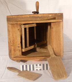
Circa late 1800s. Wooden domestic butter-churn. This is a paddle churn, a barrel that contains a paddle, which is operated by a handle. The paddle churned the butter inside the container when the handle was turned. Early settlers had to be self sufficient, growing their own vegetables, making tools and clothing and usually had a house cow to produce their milk supply. An unsigned note states it was used by a Chinese market-gardener’s family. From the mid 1800s into the1900s, there were numbers of Chinese market gardeners working in Bentleigh, Moorabbin, Mc Kinnon, and Cheltenham in the Shire of Moorabbin. After the sale of land following 'Dendy's Special Survey' 1841 many Chinese settlers rented allotments and established market gardens in the area and sold their produce to the increasing population of Melbourne at the markets in St Kilda and Melbourne.Circa late 1800s. Wooden domestic butter-churn consisting of a wooden barrel with a lid and a crank that manually turned a paddle inside to separate the butter fat from the butter milk 'BUTTER CHURN' written in chalk undated, unsignedchinese, melbourne, brighton, moorabbin, butter, cows, milk, pioneers, dairy, settlers, fruit, bentleigh, markets, mckinnon, cheltenham, vegetables, dendy henry -
 City of Moorabbin Historical Society (Operating the Box Cottage Museum)
Tool - Farm Machinery, Horse-drawn Furrow Plough, Early 20th Century
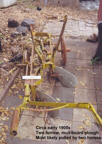
Late 1800s-early 1900s A horse-drawn furrow plough is an example of the type of farm implement widely used by pioneer market gardeners in the Moorabbin Shire following 'Dendy's Special Survey' of 1841 and the Crown Land Sale in 1852. Land allotments were bought by pioneer settlers who established or rented allotments for market gardens in the area. They supplied produce to the markets in St Kilda and Melbourne. During the gold-rush of the 1850s the rapidly increasing population of Melbourne saw a huge demand and a rise in prices for all foodstuffs, including the vegetables and fruit grown in the Shire of Moorabbin. This heralded a time of prosperity for market gardeners, and an equally rapid expansion of the numbers of vegetable and produce growers in the area. The 'knock-on effect" resulted in an increased interest and development of the community in the Shire of Moorabbin.Following 'Dendy's Special Survey' of 1841 and the Crown Land Sale in 1852, land allotments were bought by pioneer settlers who established or rented allotments for market gardens in the area and they supplied produce to the markets in St Kilda and Melbourne. During the gold-rush of the 1850s the rapidly increasing population of Melbourne saw a huge demand and a rise in prices for all foodstuffs, including the vegetables and fruit grown in the Shire of Moorabbin. Circa late 1800's to early 1900s. A horse-drawn furrow plough was the most common type of agricultural implement used by the pioneers of the 1800s and continued on into the 1940s when motorised tractors came into use. This plough is an example of a two furrow, mullboard plough which would most likely have been pulled by two horses. The long handle was used to lower the silver plates, (mullboards), to the chosen depth of soil. Painted yellow. Although this Box Cottage museum plough is unbranded, the most widely used plough in the Shire of Moorabbin was made by Oliver. This plough appears to be identical to that brand. brighton, moorabbin, pioneers, fruit, bentleigh, vineyards, vegetables, plough, market gardens, plow -
 City of Moorabbin Historical Society (Operating the Box Cottage Museum)
Photograph - Plateway (Wheelway) Steel, circa 1885
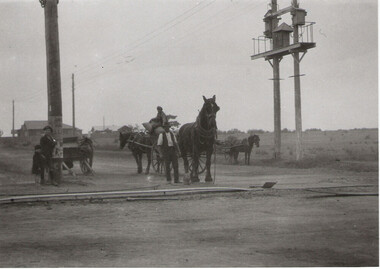
By the later 1800s the dirt roads in the then out-lying areas of the City of Moorabbin became dangerous, and almost impassable due to huge potholes and muddy swampy areas. The heavily laden market gardener’s carts regularly broke axles and wheels, and horses foundered on their way to the Melbourne markets. Even worse, the heavier “iron maidens”, carrying their malodorous loads of sewage from Melbourne’s inner suburbs for dumping in the outlying areas of the City of Moorabbin, also got bogged in the mire. It was decided that a practical solution to this problem was to install a metal plateway on the side of the problematic roads. In about 1887 the Moorabbin Shire Centre Road, in the Brighton East area, two parallel metal rails were installed so that the wheels of carts could run along smoothly, the horse travelled in the filled, middle area between the rails. Point Nepean Road plateway was removed in 1930 and Centre Dandenong Road plateway was removed in 1934-35. The worn plateway along Centre Road, East Brighton (now known as Bentleigh), was gradually taken up in several pieces, commencing in the the1920s, when its condition deteriorated and it caused a hazard to bikes, pedestrians, motor-cycles and the few early cars. The early steel plateway, constructed by David Munro, and opened on 23rd March 1885 by Thomas Bent, was built along Nepean Highway, between Asling St. and Bay St. The Point Nepean Track was subsequently extended into Moorabbin with branches along Centre, Cumins, South, Wickham, and Keys Roads, the total length was 13 miles. In 1908-1909 plates were laid along Centre Dandenong Road to Ross Street Bentleigh This innovative solution proved successful and was used until gradually the main roads were upgraded, and motorised vehicles started to appear. Two parallel metal rails were installed in the right hand side of a few main roads in the Shire of Moorabbin so that the wheels of heavily-loaded market gardener's carts on their way to markets in Melbourne could run along smoothly. The horse pulling the carts travelled in the filled, middle area between the rails. The Steel Plateway was constructed by David Munro, and opened on 23rd March 1885 by Thomas Bent. The wheelway first only ran along Nepean Highway, but it soon extended from Centre Dandenong Road, along Nepean road to its junction with Chapel Street, St Kilda. Later branch lines were built along Centre Road, Bentleigh as far as Warrigal Road and, according to early photographs, along Wickham Road Moorabbin as well. This innovative solution proved successful and was used until gradually the main roads were upgraded, and motorised vehicles started to appear. There was a problem with the wheelway : there was only a single set of rails and this was established on the right-hand side of the Nepean Road, travelling towards the city. Traffic FROM the city travelled on the correct or left-hand side of the road. The exception to this rule was the malodorous iron-clads, heavily riveted iron carts, generally travelling in convoy, carrying several tons of human effluent out of Melbourne to be trenched-in in the sandy soil of the Moorabbin district. Moorabbin City Council donated and installed a small section of Plateway at Box Cottage Museum in 1984melbourne, brighton, moorabbin, roads, plateway, wheelway, transport, st kilda, bent thomas, munro david, market gardens, steelway, carts horse-drawn, iron maidens, point nepean track -
 City of Moorabbin Historical Society (Operating the Box Cottage Museum)
Tool - Horse-drawn Metal Scoop Road-working
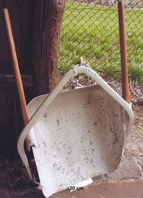
This medium sized metal, horse-drawn, road-working scoop, with timber shafts is an example of those used in Moorabbin Shire in the late 1800s, and up until the 1940s for road-works, building dams, market-gardening work and other similar earthworks in the shire. The Box Cottage museum example would have been drawn by one horse, with the worker walking and steering the horse and scoop from behind using the timber shafts. There were even bigger metal scoops that required two or more horses to drag the scoop through the soil.Following the Dendy Special Survey 1841 allotments were sold to pioneer settlers who established market gardens in the Moorabbin area. Roads and roadside dams were needed as they transported both their stock and garden produce to markets in St Kilda and Melbourne By1880 the Shire of Moorabbin was using horse-drawn, road-working shovels on the main thoroughfares of the district.A medium sized metal, horse-drawn, road-working scoop, with timber shafts. Used by Moorabbin Shire in the late 1800s, and early 1900s for road-works, and other similar work in the shiremelbourne, shovel, brighton, moorabbin, metal, gardens, roads, markets, mckinnon, cheltenham, horse drawn, scoop, dendy henry, st kilda -
 Bendigo Historical Society Inc.
Document - ART OF SIDNEY NOLAN, PROGRAM FOR EXHIBITION BENDIGO 1972, 07/08/1972
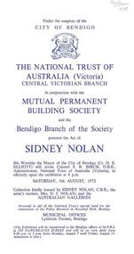
Three copies of program for an art exhibition August 7 until August 11, 1972. Those associated with the exhibition are: City of Bendigo, The National Trust of Australia (Victoria) Central Victorian Branch, Mutual Permanent Building Society, Mrs D. I. Nolan and the Australian Galleries. The brochure names the twelve paintings, on exhibition by Sidney Nolan and Portrait of Sidney Nolan, by Christine Backhaus. There is also a short biography on Sidney Nolan. Handwritten in the top right corner of one copy is: Bush 1972.art, document, art of sidney nolan, city of bendigo, the national trust of australia (victoria) central victorian branch, mutual permanent building society, sidney nolan, cr d e elliott, colonel s r birch o b e, australian galleries, christine backhaus, the age, sidney henry nolan, dora irene nolan (sutherland), mrs l sweet, mrs m goslin, brighton technical school, raymond nolan, malcolm goslin, prahran technical school, national gallery art school, serge lifar, icarus, colonel de basil, kelly gang, unesco gallery paris, paradise gardens, her majesty the queen, arts centre st kilda road, prince phillip, lord snowdon, rev. fr. j p stockdale, mr a j watts, rosalind landells, feargus niall, mari mullins, brian mcgrath, bush -
 St Kilda Historical Society
Photograph, Harry Hawker plaque, St Kilda home - images collection
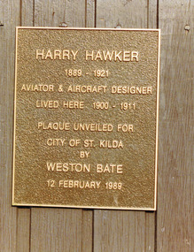
Harry George Hawker was born on 22 January 1889 at South Brighton, Melbourne. He was the son of George Hawker, blacksmith, and Mary Ann Hawker, née Anderson, both Victorian-born. He attended schools at Moorabbin, East Malvern, St Kilda and Prahran. In 1901, he left school at the age of 12 and became a trainee mechanic at the Melbourne branch of Hall & Warden bicycle depot. In 1905 he joined the Tarrant Motor and Engineering Co. as a qualified mechanic and, in about 1907 he set up his own workshop at Caramut, western Victoria. In 1911 he left for England with the intention of becoming an aviator. In June 1912, he was employed by Sopwith Aviation Co. Ltd and worked on the Sopwith-Wright biplane. He enrolled in a flying school where he was personally taught by Sir Thomas Sopwith, and obtained his licence a few months later. He went on to become a test pilot, a renowned aviator who won many competitions, and a designer who improved aircraft safety and performance. He was killed while flying a French Goshawk on a trial run near Hendon, England, on 12 July 1921. Colour photograph unmountedOn the plaque: Harry Hawker 1889-1921 Aviator & Aircraft Designer lived here 1900-1911. Plaque unveiled for City of St Kilda by Weston Bate 12 February 1989st kilda, plaques, harry hawker, hg hawker, gourlay street -
 St Kilda Historical Society
Photograph, St Kilda Municipal Depot, Inkerman Street - images collection, 1979
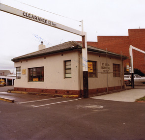
Prior to its demolition in 1979, the St Kilda Municipal Depot occupied a 1.2 hectare site at 33 Inkerman Street St Kilda. The land was initially purchased by the Council in 1867 as a site for a permanent market, which ceased to operate in about 1882. In October 1923, the Council discontinued the practice of disposing garbage by burial in tips when it opened a garbage incinerator at the Depot. After thirty years this incinerator had become both obsolete and objectionable to health and was replaced in March 1953 by American-designed Monohearth Garbage Destructor Units. According to the Council, these Destructor Units were the only ones of their kind in Australia and they removed all the objectionable features of garbage disposal (particularly for the employees). They were expected to serve St. Kilda's requirements for the next 80-100 years. In 1957 the Council said that the Destructor Units had 'enabled substantial economies to be effected in the annual costs and have proved a very successful venture. The Council now destroys the garbage from the City of Brighton, which pays for the privilege, and it is anticipated that other Municipalities will also take advantage of ihe benefits of this modern and, in Australia.' See 'City of St Kilda 1857-1957 A Brief Outline of Progress and Development' [82] In 1994, as a result of the local government amalgamation process combining the former Cities of Port Melbourne, South Melbourne and St.Kilda, the new City of Port Phillip owned three municipal depots. The St. Kilda municipal depot site became surplus to requirements and, in 1996, the City of Port Phillip resolved to use the site for a community housing project under the City of Port Phillip Housing Program. Colour photographCouncil Yards before demolition 1979st kilda, st kilda municipal depot, inkerman street, council depot, destructor -
 St Kilda Historical Society
Photograph, St Kilda Presbyterian Church exterior - images collection, c 1970s
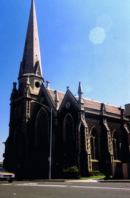
The St Kilda Presbyterian Church is now part of the St Kilda & Balaclava Presbyterian Church. Its first service was inaugurated by the Free Church Synod of Victoria in May 1855, in a building at the corner of High Street and Alma Road. In October 1855 the congregation moved to a wooden building in Inkerman Street, purchased from the Independent (Congregational) Church. The present church site was purchased and the first church opened in 1860. The foundation stone for the present church building, the second to be built on the site, was laid by the Governor of Victoria, Sir Henry Brougham Loch, on 27 January 1885. The building was opened on 30 May 1886. Wilson and Beswicke were the architects. Ralph Wilson designed the Methodist church on the corner of Princes and Fitzroy Streets and lived diagonally opposite the Presbyterian church. Charles Beswicke had toured Britain and the Continent in 1886 armed with a camera and returned to Australia with photographs of what he considered the greatest examples of architecture. He was responsible for the town halls in Brighton, Malvern, Hawthorn and Essendon and Wesleyan churches in Camberwell and Dandenong. Thomas Corley was the builder. The lofty spire was ‘a landmark to the mariner’ used by sea captains sailing up Port Phillip Bay. On a prominent position, the highest point in St Kilda, the church attracted wealthy people with legal, merchant and pastoral backgrounds.colour photographst kilda, churches, presbyterian church, balaclava -
 St Kilda Historical Society
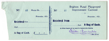
Administrative record - Form, Brighton Road Playground Improvement Carnival receipt, 1921
Uncompleted forms for receipt of money at the Brighton Road Playground Improvement Carnival, 1921Blue coloured uncompleted paper forms printed in blueNumbered 43-59, stamped in blue. Name of the Treasurer stamped in purple. (17 forms)brighton road playground, city of st kilda -
 St Kilda Historical Society
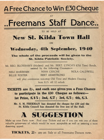
Ephemera - Poster, Freemans Staff Dance, 1940
Advertisement for Freemans Staff Dance at the 'new' St Kilda Town Hall on 4 September 1940 with proceeds going to the St Kilda Patriotic Society. The St Kilda Town Hall opened in 1890 in incomplete form, comprising only the hall, the front wing and Carlisle Street wings. In 1925 the portico and elaborate internal stair-hall were added. In 1939 an addition on the Brighton Road side, including a new Art Deco style Council Chamber, was built.Poster on white paper (discoloured with age) printed in black on one sidest kilda patriotic society, st kilda town hall, freemans dances, wwii fund-raising -
 St Kilda Historical Society
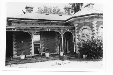
Postcard, Brighton Rd (south west)
Photo shows two adults and four children with croquet sticks in hand in front of building black and white photograph, unmounted, copy, good conditionOn back: Brighton Road, w side Built for Emil Thoneman, Merchant. Demolished approx 1960. Flats now on the site in Wimbledon Avenue -
 St Kilda Historical Society
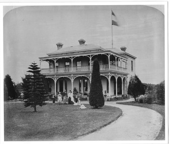
Postcard, Sydenham Villa 43 Brighton Rd, St Kilda
... Sydenham Villa 43 Brighton Rd, St Kilda...Front of Sydneham Villa, 43 Brighton Road, St Kilda...Sydneham Villa, 43 Brighton Road, St Kilda. Built in 1863...43 Brighton Road, St Kilda, Victoria, Australia... Brighton Road, St Kilda Sydneham Villa, 43 Brighton Road, St Kilda ...Front of Sydneham Villa, 43 Brighton Road, St Kildablack and white photograph, unmounted, original, fair conditionSydneham Villa, 43 Brighton Road, St Kilda. Built in 1863 - owner David Lyons died there in 1883. Sydenham Villa demolished in 1983. In pencil: Mrs Hall owned it about 1970. -
 St Kilda Historical Society
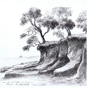
Photograph - Lithograph, c. 1857
handwritten: R4082 E von Guerard pen NLVBlank and white photograph of drawing by E von Guerard. Unmounted.Near the Red Bluff Brighton 5 Feb 1857. R4082 E.Von Guerard pen NLV. 6-213.SKHS 1021 -
 St Kilda Historical Society
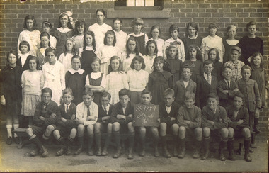
Photograph, St Kilda Primary School Grade 6, c. 1921
... Carlisle Street St Kilda melbourne other information: Brighton Road ...other information: Brighton Road Primary Schoolblack and white photograph fair condition mountedState school 1479, Grade 6 -
 St Kilda Historical Society
Photograph, 22 November 1933
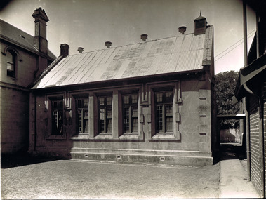
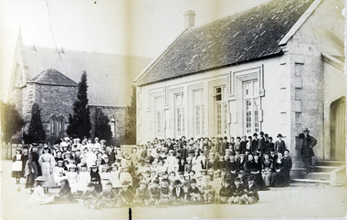
This school was one of the earliest in St Kilda. The 1842 plan of Crown Lands that were sold to establish what became the village of St Kilda reserved an area on Acland Street for the 'Church of England and School'. Christ Church was constructed on the site in 1854-57. A school had started before then but was closed for about a year after the Head Teacher abandoned his students in search of gold. A sign on the door read 'This school is closed in consequence of the master having gone to the diggings'. The school was re-opened in 1853, with only two pupils on the first day. The new Headmaster was John Hadfield, a teacher who had recently arrived in Melbourne from Wiltshire, England. He stayed on as Headmaster for the next 22 years. Free secular compulsory education was introduced in Victoria from 1873. Until a permanent State school could be built in the area, the Government used the St Kilda Town Hall for this purpose, and the students from Christ Church school were transferred there. The Brighton Road State School was opened in January 1875, with John Hadfield was its first Headmaster. The Government then leased the old Christ Church schoolroom and established a second school there. The Headmaster was James A Ure. The school continued until the 1940s. The building was burnt down in 1977.The building burnt down in 1977.black and white gloss photograph good condition unmountedFirst State School in St Kilda, Acland St, St Kilda 22 Nov 1933st kilda, christ church, acland street, st kilda schools, john hadfield, james a ure, christ church school, christ church college -
 St Kilda Historical Society
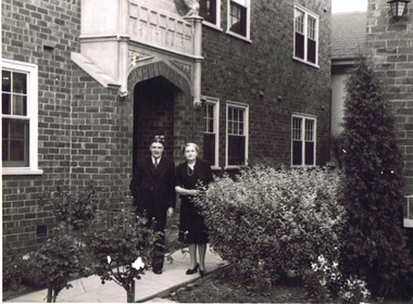
Photograph, Alan and Ida Mickle
... Alan and Ida Mickle at their Brighton Road, St Kilda flat...Brighton Rd, St Kilda, Victoria, Australia... at their Brighton Road, St Kilda flat. Box 248/2. 110 black and white ...black and white photographAlan and Ida Mickle at their Brighton Road, St Kilda flat. Box 248/2. 110 -
 St Kilda Historical Society
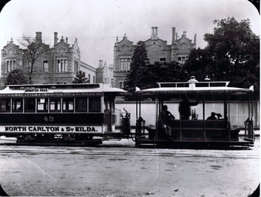
Photograph, CableTram, c. 1905
... 1900. CableTram (North Carlton to St Kilda) in Lonsdale St...St Kilda Historical Society St Kilda Branch Library 150 ...also stamped on back D.J. Taggartblack and white photograph1900. CableTram (North Carlton to St Kilda) in Lonsdale St, Melbourne about 1905. Brian Pump 36 Knaith road, Ringwood East. Phone: 8707001. Rathdowne, Lygon and Swanston sts and St Kilda rd. Rathdowne st to Brighton rd. 49 North Carlton and St Kilda. -
 St Kilda Historical Society
Photograph, c. 1865?
This school was one of the earliest in St Kilda. The 1842 plan of Crown Lands that were sold to establish what became the village of St Kilda reserved an area on Acland Street for the 'Church of England and School'. Christ Church was constructed on the site in 1854-57. A school had started before then but was closed for about a year after the Head Teacher abandoned his students in search of gold. A sign on the door read 'This school is closed in consequence of the master having gone to the diggings'. The school was re-opened in 1853, with only two pupils on the first day. The new Headmaster was John Hadfield, a teacher who had recently arrived in Melbourne from Wiltshire, England. He stayed on as Headmaster for the next 22 years. Free secular compulsory education was introduced in Victoria from 1873. Until a permanent State school could be built in the area, the Government used the St Kilda Town Hall for this purpose, and the students from Christ Church school were transferred there. The Brighton Road State School was opened in January 1875, with John Hadfield was its first Headmaster. The Government then leased the old Christ Church schoolroom and established a second school there. The Headmaster was James A Ure. The school continued until the 1940s. The building was burnt down in 1977.The building burnt down in 1977.Framed and mounted original photograph, black and white. First state school room in Victoria.st kilda, christ church, acland street, st kilda schools, john hadfield, james a ure, christ church school, christ church college -
 St Kilda Historical Society
Print, St Kilda Nurseries, C Brunning & Son
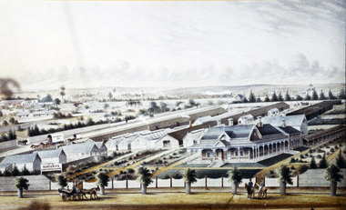
painted in 1876Colour lithograph, mounted and framed. Brunning house in foreground with the hothouses on the RHS and sheds to the rear, House depicted as single storey with verandah across the front and southern side. Brighton Road carriageway in foreground. Railway line with train to the rear. -
 Uniting Church Archives - Synod of Victoria
Tool - Music baton
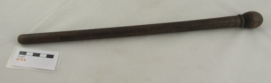
W E Herring and his wife arrived in Brighton in 1887 to live in Roslyn Street. They had both been active members of the Fitzroy Street, St Kilda church choir. In 1937 Mr Herring recalled church life in the 1880s and 1890s. Houses were scarce and to reach the Wesleyan Methodist Church in Were Street, Brighton Beach a creek which had no bridge had “to be crossed – in winter, with the help of a hurricane lamp – and it was no uncommon thing for the preacher, if he were a stranger, to arrive late and breathless, or not at all.” In 1907 permission was given to form a tennis club at Were Street and Mr Herring was its first president. He was also the Were street Methodist Sunday School Superintendent, the Were street Methodist church organist and a member of the church’s Trust. “The Sunday School had a fine set of teachers. The rows of well-drilled and disciplined young life that filled the platform on Sunday School anniversaries, and sang their songs under the baton of Mr Herring, constituted a promise that was amply fulfilled as the years rolled on.”* *”Fifty years ago : a little history of Were Street Methodist Church” : Issued in commemoration of its Jubilee by Members of the Trust 1887 – 1937. To celebrate Queen Victoria's Diamond Jubilee Mr Herring composed an anthem. The Brighton Southern Cross, Saturday 26 June 1897, page 2 reported: "The diamond jubilee has been instrumental in evoking some local musical talent. Mr W. E. Herring, organist of the Were-street Wesleyan Church, not being able to find any anthem specially suitable to the jubilee services, set his musical genius to work and composed an original piece. The words are selected from the 72nd Psalm. The music is a very tuneful and well harmonised theme, which does credit to the composer's skill and taste. The anthem was rendered twice on Jubilee Sunday at the Were street Church." Stained wood turned music baton.w e herring, were street methodist sunday school superintendent, music baton, were street wesleyan methodist church -
 Uniting Church Archives - Synod of Victoria
Photograph, Reverend Wesley Johns
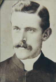
Reverend Wesley Johns was born in Victoria in 1864 and died in Box Hill in 1933. He commenced his ministry in 1886. He was stationed at Benalla and Euroa 1886, Wodonga 1887 Dromana 1888 Nathalia 1889 Kerang 1890 Horsham 1893 Blackwood 1895 Kilmore 1898 Forth 1901 Wangaratta 1904 Portland 1907 Brighton New Street 1910 North Melbourne 1912 Colac 1916 Ringwood 1921 St Kilda 1924 Oakleigh 1926. He was Financial Secretary of District between 1918 and 1926.B&W photograph head and shoulders.johns, wesley, reverend -
 Uniting Church Archives - Synod of Victoria
printed etching
... , bridgport, south shields, glasgow, st. kilda, ballarat east... in Australia in 1856. Stationed in N.S.W. then at St. Kilda, Ballarat ...William Abraham Quick (1820 - 1915). Born in the U.K. Methodist minister at Liskeard Cornwall, Tiverton Devon. In 1843 went to Sierra Leone. Upon returning to the UK was stationed at Bridport, South Shields, Glasgow. Arrived in Australia in 1856. Stationed in N.S.W. then at St. Kilda, Ballarat East, Richmond. President of the Australasian Conference 1866. President of Horton College at Ross, Tasmania. Founder and President of the Council of Queen's College, University of Melbourne. Died at Brighton 12 November 1915.B & W printed etching of the Rev. William Abrahm Quick in three quarter profile."Revd Willam A. Quick President of the Australasian Conference 1866"william abraham quick, wesleyan, methodist, minister, horton college, queen's college, liskeard, tiverton, sierra leone, bridgport, south shields, glasgow, st. kilda, ballarat east, richmond, brighton, president of conference -
 Hume City Civic Collection
Photograph
... Brighton Road / St. Kilda / Tel. Windsor 3678... / St. Kilda / Tel. Windsor 3678 Mounted b/w photgraph of Dr ...Born in Ireland 1864, Daniel Mannix entered into the Catholic Church and in 1917, he became the Archbishop of Melbourne. Dedicated to the community and its issues, he was known to have spoken against conscription. In 1963, at the senior age of 99, Daniel Mannix passed and was buried in St Patrick's Cathedral, Melbourne. Mounted b/w photgraph of Dr. MannixStamped on back: ALF. H. WALL / PHOTOGRAPHER / "Espero," 40 Brighton Road / St. Kilda / Tel. Windsor 3678clergymen, mannix, - (dr), george evans collection -
 Ballarat Tramway Museum
Ephemera - Timetable/s, Melbourne and Metropolitan Tramways Board (MMTB), Set of 24 MMTB Melbourne tram timetables, 1969
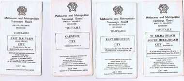
Set of 24 MMTB timetables for various routes, dated July 1969. Generally includes Sat and Suns, Good Friday and Christmas day as well as weekdays, unless noted otherwise. Also includes a map of the route, detailed time points, sections, connecting services, fares, and organisation address - 616 Little Collins St. Melbourne. Have been folded into ten portions. All on white paper unless noted otherwise. Items shown with an # - have a sticker modifying timetable information details on the front page. 1154.1 - Route 4 - Carnegie - City .2 - Route 4D - East Malvern (Darling Road) - City # .3 - Route 5 - Malvern Burk Road, - City # .4 - Route 6 - Glen Iris - City # .5 - Route 7 - Camberwell - City # .6 - Route 8 - Toorak - City # .7 - Routes 9, 10 and 12 - South Melbourne and St Kilda Beach - City (Brunswick St.) - via Collins St. .8 - Routes 10, 11 - West Preston and routes 9 & 9A Northcote .9 - Routes 15 & 22 - Moreland and 1 & 21 - East Coburg .10 - Route - 15 & 16 - St Kilda Beach and 1 & 2A - South Melbourne Beach - via Swanston St. .11 - Route 19 - North Coburg - City # .12 - Route 42 - Mont Albert - City # .13 - Routes 48 - North Balwyn and Burwood - City .14 - as above, but for Saturdays and Sundays on pink paper .15 - Routes 55 & 56, West Coburg - City - (William St.) - Domain Road. .16 - Route 57 - West Maribyrnong - City .17 - Route 59 - Essendon (Aerodrome) - City .18 - Route 64 & 65 - East Brighton - City .19 - Route 69 - Kew Cotham Road - St. Kilda Beach # .20 - Route 70 - Wattle Park - City # .21 - Routes 77 - Prahran - City, 78 - North Richmond - Prahran, 79 - North Richmond - St Kilda Beach .22 - Route 82 - Footscray to Moonee Ponds .23 - Route 88 - East Preston - City and Route 96, East Brunswick - City .24 - as above but for Saturdays and Sundays on pink paper. Images of a sample of documents added 16-11-2013.mmtb, timetables, melbourne -
 Ballarat Tramway Museum
Photograph - B&W print of donated negative, Ron E. Fluck, 7/04/1950 12:00:00 AM
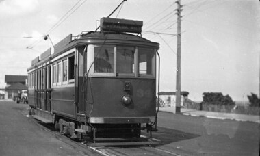
Black and white print of a donated negative. Print made 8/1998. Photo of Victorian Railway tram No.34 at the Brighton Beach terminus. Tram has the destination of "St Kilda Rly Stn". In the overhead can be seen the pan for assisting the driver to put the rear pole onto the wire. Also in the background of the photo is a stone wall of the railway tunnel under the road that served the Brighton Beach Pier. Photo taken 7-4-1950. See Victorian Railways to '62, pages 47 and 49 re railway tunnel.tramways, trams, brighton beach, vr, railway tunnel, tram 34 -
 Bendigo Historical Society Inc.
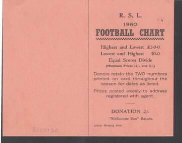
Document - R.S.L. BENDIGO COLLECTION: R.S.L. 1960 FOOTBALL CHART
Orange card titled R.S.L. 1960 Football Chart. On the front is how it works. Donation 2/-. Melbourne Sun Results. Printed by Arthur Hocking Print. On the other side is the list of the teams and the dates from 16/4/60 to 20/8/60. The Football clubs are: Melbourne, Sunshine, Geelong, Preston, Fitzroy, Box Hill, Richmond, Yarraville, South Melbourne, Oakleigh, St. Kilda, Brunswick, Hawthorn, Sandringham, Collingwood, Brighton, Footscray, Northcote, Moorabbin, Essendon, Coburg, North Melbourne, Camberwell, Carlton, Williamstown, Port Melbourne, Dandenong and Mordialloc.Arthyr Hocking Print.clubs and associations, football, football chart, r.s.l. bendigo collection - r.s.l. 1960 football chart, melbourne sun, arthur hocking print, melbourne, sunshine, geelong, preston, fitzroy, box hill, richmond, yarraville, south melbourne, oakleigh, st. kilda, brunswick, hawthorn, sandringham, collingwood, brighton, footscray, northcote, moorabbin, essendon, coburg, north melbourne, camberwell, carlton, williamstown, port melbourne, dandenong, mordialloc -
 Bayside Gallery - Bayside City Council Art & Heritage Collection
Photograph, Department of Crown Lands and Survey, Victoria, Melbourne Project: Brighton and Elwood, 1976
The Department of Crown Lands and Survey (1857-1983) was responsible for the administration of survey and mapping and the sale, occupation and management of crown land throughout its existence. This aerial photograph shows parts of Brighton and Elwood and was taken on 1 December 1976brighton, elwood, department of crown lands and survey, aerial photograph, elsternwick park, point ormond, north road, ormond esplanade, st kilda street, glen huntly road, bayside, port phillip bay, map, cartographic material, melbourne project 1976 -
 Bayside Gallery - Bayside City Council Art & Heritage Collection
Photograph, Department of Crown Lands and Survey, Victoria, Melbourne Project: Brighton, 1976
... St Kilda Street New Street Black and white photograph ...The Department of Crown Lands and Survey (1857-1983) was responsible for the administration of survey and mapping and the sale, occupation and management of crown land throughout its existence. This aerial photograph shows parts of Brighton and was taken on 1 December 1976brighton, department of crown lands and survey, aerial photograph, bayside, port phillip bay, map, cartographic material, melbourne project 1976, brighton yacht club, middle brighton baths, north road, st kilda street, new street -
 Bayside Gallery - Bayside City Council Art & Heritage Collection
Photograph, Department of Crown Lands and Survey, Victoria, Brighton, Elwood and Elsternwick, c. 1965-71
The Department of Crown Lands and Survey (1857-1983) was responsible for the administration of survey and mapping and the sale, occupation and management of crown land throughout its existence. This aerial photograph shows parts of Brighton, Elwood and Elsternwick and was taken circa 1965-71.brighton, department of crown lands and survey, aerial photograph, bayside, port phillip bay, map, cartographic material, elwood, elsternwick, elsternwick park, elwood tram depot, elwood pier, new street, glen huntly road, st kilda street, nepean highway -
 Kew Historical Society Inc
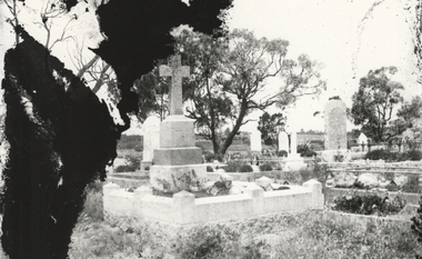
Photograph, Graves, St Kilda Cemetery, c.1925
This photograph was printed from a glass negative held in the Society's picture collection. The original glass negative is part of a set donated to the Society by Ian McKenzie, a professional photographer in Kew. Graves within a cemetery, post 1914. A photograph of graves in a cemetery. The photograph, of unknown provenance, is on the lower half of a glass negative. The upper half can be seen in PIC 0053. Given that the upper half is of a grave in Brighton Cemetery, it is possible that this is also the location shown in this photograph.st kilda cemetery, graves, glass negatives