Showing 827 items
matching surveyor
-
 Whitehorse Historical Society Inc.
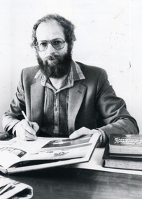
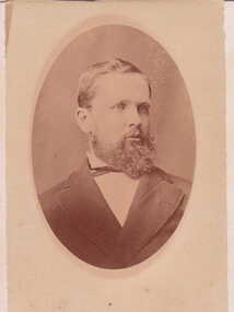
Photograph, Roger N. Hannaker
Black and white photo of Roger N. Hannaker, President Australian Institute Building Surveyors, Vic. Chapter. Also Manager, Buildings, City of Nunawading.hannaker, roger n., australian institute of building surveyors -
 Clunes Museum
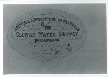
Document - MAP
CLUNES WATER SUPPLY DRAWINGS & DESCRIPTIONS OF THE WORKS PRESENTED TO P.F. ADAMS ESQUIRE SURVEYOR GENERAL OF NEW SOUTH WALES WITH OCT. LANGHAMS COMP.DRAWINGS AND DESCRIPTIONS OF THE WORKS OF CLUNES WATER SUPPLY.local history, photography, photographs, water supply -
 Port of Echuca
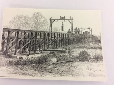
Photograph - Black and white photograph of a drawing, A black and white photograph of a drawing of the construction of the bridge crossing the Murray River at Echuca in 1887, 1981
The drawing shows all the activity and building roles involved in building a bridge in 1877. The crossing of the Murray River was very important to citizens living in both Echua, but especially those living in Moama and in further NSW regions as it provided them with access to Victorian market regions. The bridge was built privately for Deniliquin farmers, but eventually opened up to the general public.This is significant because it represents the roles of different tradesmen in the construction industry in the late 19th Century. It also shows construction stages . Bridge pylons are being inserted into the fiver banks. It is also a very well produced drawing, the artist is anonymous, but very skilled.A photograph of a drawing of the construction of the bridge crossing the Murray River in 1877. The picture shows surveyors, construction workers, crane operators, hoists and a crane and much activity.Written on the back in pen are the numbers 6530. In pencil are the numbers 61/8"? and 10"?. Stamped on the back is a small rectangle with the words 'COPYRIGHT. This photograph may not be reproduced without permission in writing from the Editot of "The Age" 250 Spencer Street Melbourne, and 39/41 York St., Sydney.' written inside it.bridge works, murray river crossing, moama, echuca, orm cook collection, 'the age' newspaper., deniliquin farmers, engineering, bridge building, pylons, 1877 -
 Phillip Island and District Historical Society Inc.
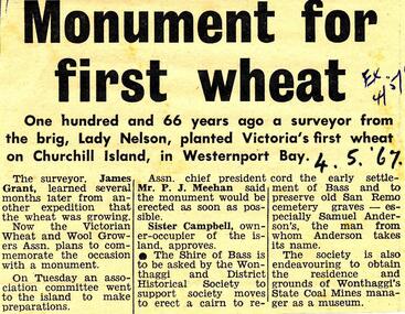
Newspaper Clipping, First Wheat planted in Victoria, 4/5/1967
Collection of newspaper clippings from Scrap Book 1960 - 1973Article about the first wheat planted in Victoria on Churchill Island by surveyor James Grant 166 years ago and a Monument should be erected to commemorate the occassion.first wheat crops for victoria, churchill island, james grant, newspaper clipping, jean jamieson -
 Bendigo Historical Society Inc.
Slide - RALPH BIRRELL COLLECTION: EIG SCHOOL, c1966
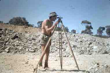
EIG School - Ralph Birrell Collection. - Construction of Latrobe Uni. C1966. Bendigo Institute of Technology, Engineering School, Applied Science. Surveying with surveyors tripod.Kodakeducation, tertiary, latrobe university bendigo, eig school - ralph birrell collection. - construction of latrobe uni. c1966. bendigo institute of technology, engineering school, applied science. surveyors tripod. -
 Port Melbourne Historical & Preservation Society
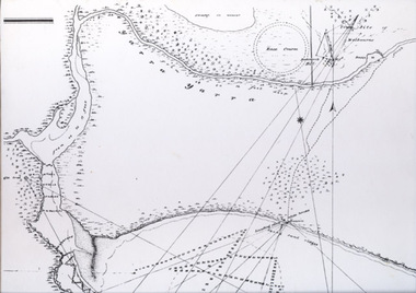
Map - Track, Sandridge to Melbourne, 1840
Bromide of surveyor's sketch of the track to Melbourne from Sandridge (Liardet's Beach), 1840. Originals with Lands Department, Melbourne. (possibly the work of William Wedge DARKE?)Slight processing stain upper right, '6' on backbusiness and traders - hotels, william wedge darke, piers and wharves -
 Bendigo Historical Society Inc.
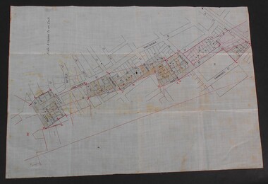
Document - WES HARRY COLLETION: SURVEORS MAP ON LINEN OF HONEySUCKLE AND THISTLE STREETS
A surveyor's map to scale 4 chains to 1 inch of Honeysuckle & Thistle Streets, between Alley Street and Clark Street Unknown purpose of the plan - undated -
 Port Melbourne Historical & Preservation Society
Plan - Raglan Street, Port Melbourne, Borough of Sandridge, 1890s
Plan of Raglan Street showing longitudinal section.Chas Clay (Borough Surveyor):E. Clark (Town Clerk):John Clang (Contractor ?)raglan street, engineering - roads streets lanes and footpaths, town clerks, charles clay, edward clark -
 Bacchus Marsh & District Historical Society
Map, O'Hagan v Shire of Bacchus Marsh, Allotment 5, Sec 16, Parish of Korkuperrimul
The purpose for this map being created or the date when it was made has not been established. It appears to be documentation relating to a legal dispute by a landowner named O'Hagan and the Shire of Bacchus Marsh. Features identified on the map are allotment 5, section 16, Parish of Korkuperrimul, a 'cultivation paddock', a section of the Werribee River, the path of a section of a 'Main Channel', and a barrier or filled in section across the Werribee River called 'Lee's Filling'. The O'Hagan is likely to be Patrick O'Hagan, 1829-1914 who arrived in Bacchus Marsh in 1864 and was a prominent citizen and landowner in the area for many years until his death in 1914.Single page map showing allotment 5, section 16 in the Parish of Korkuperrimul, Scale 4 chains to inch. Part of a set of maps which are pasted into a bound volume containing 76 maps or plans in total. High resolution digital image stored on BMDHS computer network. Stamped: Munzt, Bace and Muntz, Civil Engineers and Licensed Surveyors , 388 Collins Streetbacchus marsh victoria maps, water supply structures and establishments, watercourses -
 Bendigo Military Museum
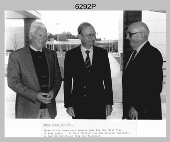
Photograph - Retired Officers of the Royal Australian Survey Corp on Corps Day, School of Military Survey, Latchford Barracks, Bonegilla, 1991
This is a photograph of three retired officers from the Royal Australian Survey Corps taken on Corps Day, at the School of Military Survey, Latchford Barracks, Bonegilla in July 1991. BRIG Don Macdonald AM served in the Australian Regular Army from 1st of January 1936 to 22nd of March 1967. He was the Director of the Survey Corps from January 1960 to March 1967. COL Macdonald was promoted to Brigadier before assuming the honorary position of Colonel Commandant of RA Svy from August 1967 to January 1973. LTCOL Bob Skitch served in the Australian Regular Army from 14th of February 1955 to 27th of February 1981. He was the CO of the Army Survey Regiment from 1976 to 1980. LT Leo Noel Fletcher MID served in the Australian Regular Army from 1st January 1938 to 14th November 1945. He was the NSW Surveyor General from 1965 to 1978.This is a photograph of three retired officers from the Royal Australian Survey Corps taken on Corps Day, at the School of Military Survey, Latchford Barracks, Bonegilla in July 1991. The black and white photograph was printed on photographic paper and is part of the Army Survey Regiment’s Collection. The photograph was scanned at 300 dpi. .1) - Photo, black & white, 1991, retired RA Svy officers – L to R: LT Leo Noel Fletcher MID, LTCOL Bob Skitch, BRIG Don Macdonald AM.Annotated on front of photo ‘RASvy Corps Day1991. Three of the Corps past members meet for the first time in many years. Lt Noel Fletcher (ex NSW Surveyor General), Lt Col Bob Skitch and Brig Don MacDonald.’royal australian survey corps, rasvy, army survey regiment, army svy regt, fortuna, asr, school of military survey -
 Bendigo Historical Society Inc.
Slide - ALLAN BUDGE COLLECTION: SLIDE HIGH STREET GOLDEN SQUARE, 1988
Slide, ALLAN BUDGE COLLECTION, Polychrome Brickwork, High Street, Golden Square. Features the following information; James Blair; Architect, Building Surveyor, Sworn Valuer.house, public, allan budge collection, allan budge collection -
 Clunes Museum
Photograph
.1 SEPIA PHOTOGRAPH MOUNTED ON CARDBOARD .2 COPY OF ABOVE PRINTED ON PHOTOGRAPHIC PAPER TOWN CLERK & SURVEYOR, BARTSON, ARTHUR. FROM COLLAGE REG 822local history, photography, photograph, councillors -
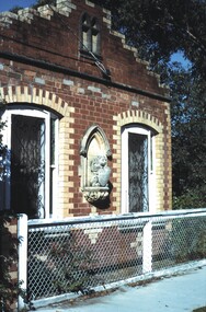
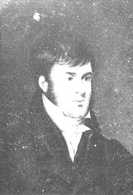 Whitehorse Historical Society Inc.
Photograph - Black and white photograph, James Blackburn
Used by donor in 'Blackburn - a picturesque history'Black & white photo of James Blackburn (1803 - 1854). He was a Melbourne city surveyor and founder of its water supply. See page 9 of the DaCosta book.blackburn, james -
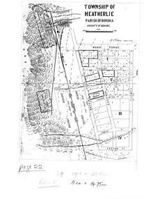 Halls Gap & Grampians Historical Society
Map - Photocopy
Photocopy of map of Heatherlie TownshipTownship of Heatherlie; Parish of Boroka; County of Borung; scale measurement; R.O. Robson Authorised Surveyormaps, heatherlie township -
 Halls Gap & Grampians Historical Society
Map - Coloured
Map showing layout for township of HeatherlieTownship of Heatherlie; Parish of Boroka; County of Borung; scale measurement; R.O. Robson Authorised surveyormaps, heatherlie township -
Port Melbourne Historical & Preservation Society
Plan - Proposed Spring Street elevation, Port Melbourne Town Hall, Arthur Victor Heath, Town Clerk, 10 Dec 1907
Plan of proposal for a new Town hall; front elevation Spring Street; cross section; longitudinal section; side elevation; floor plan. Pen drawings tinted (possibly in water colour) dated 1907Stamped "Surveyor's Office, Town of Port Melbourne":Signed "A.V. Heath 10/12/07"port melbourne town hall, arthur victor heath, town clerks -
 Flagstaff Hill Maritime Museum and Village
Document - Plan, Victorian Harbours Warrnambool, Victorian Harbours, Warrnambool, Plan to Accompany Sir John Coode's Report, 28-02-1879
This plan is of great significance to the local history of Warrnambool, in particular the Breakwater and its impact on Warrnambool's maritime and trade history. The plan shows the existing jetties at the Port of Warrnambool, plus the partially erected Breakwater and proposed works to the Breakwater by both the Borough of Warrnambool Surveyor and Sir John Coode. The plan was signed 28th February 1879 by Sir John Coode. The legend at the bottom left describes the existing works and the proposed works. The Warrnambool Breakwater Sir John Coode was a British harbour engineer. He was brought to Melbourne by the Melbourne Harbour Trust to advise on works to improve the Port of Melbourne. The Victorian Government commissioned him to present a plan to complete the Warrnambool Breakwater. His original plan was too expensive so he prepared a revised plan for a shorter structure. The work was completed in 1890. The construction proved to be too short to protect adequately from the weather and didn't allow enough depth for larger vessels to come into port. The decreasing trade was further affected by siltation in the bay due to the breakwater, and the completion of the railway line. The situation of the harbour became a real problem that, by 1910, required continuous dredging. In 1914 the Breakwater was extended but proved to be a failure because the work began to subside and by 1920 about two thirds of the harbour was silted up. Alterations made in the 1920's increased the silting problem and by the 1940's the harbour was no longer used. More alterations were made in the 1950's and 1960's. The Warrnambool Breakwater is registered as a place of significance on the Victorian Heritage Database. This plan of the proposed works for the existing Warrnambool Breakwater is of great significance to the local history of Warrnambool, in particular the Breakwater and its impact on Warrnambool's maritime and trade history. The Warrnambool Breakwater is registered as a place of significance on the Victorian Heritage Database (VHR H2024). It is historically significant to Victoria as one of the most important maritime engineering projects in Victoria in the late 19th century. The Warrnambool Breakwater is of historical significance as one of the most important maritime engineering projects in Victoria in the late nineteenth century. It is evidence of Victoria's nineteenth century investment in regional port infrastructure and the development of Victorian coastal shipping. It is of significance for its association with the English civil engineer Sir John Coode, the most distinguished harbour engineer of the nineteenth century, who was brought to Victoria to advise on works to improve the Port of Melbourne, but was retained by the Government to advise on improvements to the harbours at Portland, Geelong, Port Fairy, and Lakes Entrance, as well as Warrnambool. His projects for Melbourne, Lakes Entrance and Warrnambool were major engineering projects of the nineteenth century. The breakwater is historically significant as a reminder of Warrnambool's early maritime history as a Western District port, and as one of Victoria's major 'outer ports'. While the Warrnambool Breakwater is a demonstration of the engineering skills of the nineteenth century, it also demonstrates the limitations of knowledge relating to sedimentology at the time and the confidence apparent in a number of nineteenth century plans which assumed that natural forces could be overcome or contained by engineering.Plan of Warrnambool Harbour, Port of Warrnambool, dated 28 Feb 1879. Plan shows existing Breakwater and work proposed by both Warrnambool Borough Surveyor and Sir John Coode. Plan has gold coloured quarter-dowel rods top and bottom and a metal ring at the top. Stamped with title. Signed by Sir John Coode.Stamped "VICTORIAN HARBOURS / WARRNAMBOOL / PLAN / to accompany / SIR JOHN GOODE'S REPORT / DATED 28 FEB 1879" Signature "John Coode"flagstaff hill, warrnambool, maritime museum, shipwreck coast, great ocean road, sir john coode, borough of warrnambool surveyor, plan of warrnambool, victorian harbours, warrnambool harbour, warrnambool breakwater, port of warrnambool, vhd vhr h2024, flagstaff hill maritime museum & village, maritime village, map, chart, plan, lady bay, breakwater, jetty, pier, vhr h2024, proposed works, 1879 -
 Bendigo Historical Society Inc.
Slide - RALPH BIRRELL COLLECTION: EIG SCHOOL, c1966
EIG School - Ralph Birrell Collection. - Construction of Latrobe Uni. C1966. Bendigo Institute of Technology, Engineering School, Applied Science. Workman with site plans and surveyors tripod.Kodakeducation, tertiary, latrobe university bendigo, eig school - ralph birrell collection. - construction of latrobe uni. c1966. bendigo institute of technology, engineering school, applied science. workman site plans surveyors tripod. -
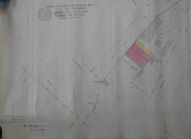 Bendigo Historical Society Inc.
Map - BENDIGO WEEROONA GASWORKS MAP/PLAN COLLECTION: CROWN ALLOTMENTS 13/14, 1942
Map: crown allotments 13 and 14, Sec. E. City of Bendigo, Parish of Sandhurst. Shows site of Bendigo Gasworks. Prepared by Garnel Gordon Birch Surveyor, 12.6.1942map, bendigo, gasworks, gas company, plans -
Stawell Historical Society Inc
Map, Township of Stawell
B/W map of Stawell Surveyed by Easton Johnston Contract surveyor Scale in Chains. Showing Special Allotments Reefs, Pleasant Creek Parish of Stawell. Map No L4000 -
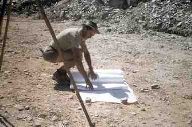
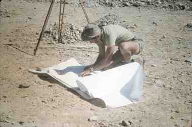
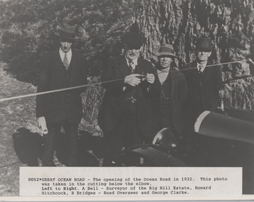 Lorne Historical Society
Photograph, Opening of Great Ocean Road by Howard Hitchcock 1932
A. Bell, surveyor,Photograph of Opening of Great Ocean Road 1932 by Howard Hitchcockgor opening 1932. a. bell surveyor. big hill estate. howard hitchock. george clarke -
Tatura Irrigation & Wartime Camps Museum
Book, Agricultural Surveying, 1901
Used by surveyorsLight brown cloth covered cardboard cover. "245" and "1/6" on the spineagricultural surveying, scott, proff j, tatura, surveying, irrigation, terrestrial -
 Bendigo Historical Society Inc.
Slide - RALPH BIRRELL COLLECTION: EIG SCHOOL, c1966
EIG School - Ralph Birrell Collection. - Construction of Latrobe Uni. C1966. Bendigo Institute of Technology, Engineering School, Applied Science. Surveyor studying the plans for La Trobe University.Kodakeducation, tertiary, latrobe university bendigo, eig school - ralph birrell collection. - construction of latrobe uni. c1966. bendigo institute of technology, engineering school, applied science. surveyor workman plans -
 Kew Historical Society Inc
Photograph - Historic re-enactment during the Festival of Kew, 1978
At the 1978 Festival of Kew, a number of organisations, including the City of Kew, the Kew Historical Society, Trinity Boys Grammar School and local Girl Guides participated in a re-enactment of the expedition of the party of Charles Grimes in surveying the Yarra River as far as Kew in February 1803. The location for the event was Yarra Bend Park near the Studley Park Boat House. The event was organised by the Kew Historical Society. The re-enactment was captured by a number of amateur photographers as well as by a photographer from the local Progress Press.Local communities select events to commemorate according to their shared history and values. Commemorations of colonial exploration were popular with local historical groups such as the Kew Historical Society in the twentieth century. In re-enacting events such as the Grimes survey of the Yarra, students from a local school were encouraged to take on specific roles, including play-acting individuals involved in the survey party as well as members of the local Wurundjeri People. The photographs, taken by amateur and professional photographers, represent a period in time when the dominant values were those shared by the descendants of European settlers in Victoria. Original colour photographic positive of six students from Trinity Grammar School, dressed in period costume, enacting in 1978 the arrival of the surveyor Charles Grimes at Studley Park in 1803. Annotated on reverse: "BOAT CREW / TRINITY BOYS AS GRIMES PARTY / 1978"kew historical society, trinity grammar school, kew girl guides, city of kew, yarra river, charles grimes, collins expedition, wurundjeri people, yarra bend park, colonial surveys, historic re-enactments, festival of kew, kew festival -
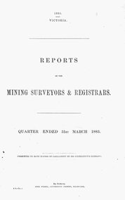 Ringwood and District Historical Society
Report, Extract from the Victoria Mining Surveyors & Registrars Reports, Quarter ended 31st March, 1883, including activities of The Ringwood Antimony Tribute Company and The Ringwood Consols Company
Catalogue card reads, "1883 - Reports of the Mining Surveyors & Registrars. Quarter ended 31st March, 1883". -
 Bacchus Marsh & District Historical Society
Map, Village allotments, Parish of Myrniong, County of Bourke
Myrniong is a village 9 kilometers west of Bacchus Marsh. Prior to 1863 the area was known as Blow's Flat. This map which was produced in 1903 and according to the catalogue record of this map held at the State Library of Victoria was based on an earlier map created in 1861. The early layout of streets for the village of Myrniong can be seen on this map. The streets shown are, Main Street, Hardy Street, Blow Street, Myrniong Street, Shuter Street, and Blackwood Street. An area marked as a reserve for a school can be seen between Hardy Street and Main Street.A single page paper map. A cadastral parish map of Myrniong in Victoria, showing numbered land allotments. Photo-lithographed at the Department of Lands & Survey, Melbourne, in 1903. Based on an original map created in 1861. The map is pasted into a bound volume containing 76 maps or plans in total. High resolution digital image stored on BMDHS computer network. Surveyed by John Hardy, Surveyor ; photo-lithographed at the Department of Lands & Survey, Melbourne by T.F. McGauran, 24.12.03myrniong parish plan, myrniong parish maps -
Clunes Museum
Plan - PLANS CLUNES CARAVAN PARK, NO. 1 - SHIRE OF TALBOT & CLUNES. IAN MANSLEY, SHIRE ENGINEER NO. 2 - LEO MCMAHON & ASSOCIATES PTY. LTD. LICENSED SURVEYORS & ENGINEERS, 31 LYONS ST. NTH. BALLARAT, 1976
NO. 1 PLAN - CLUNES CARAVAN PARK ENGINEER - IAN MANLEY NO. 2 PLAN - SECTION 15 TOWNSHIP OF CLUNES, COUNTY OF TALBOT, BY LEO MCMAHON AND ASSOCIATES, LICENSED SURVEYORS AND CIVIL ENGINEERSplans, caravan park, ian manley, plan section 15 -
 Kew Historical Society Inc
Plan - Subdivision Plan, Argyle Road, Heather Grove, Victor Avenue, Kew, c.1937
The Kew Historical Society's map collection includes a substantial number of real estate subdivision plans, mainly of Kew but also of surrounding suburbs in Melbourne. Most of the subdivision plans date from the 1920s and 1930s when the districts old homes and local farmland were being split up to accommodate residential growth in the postwar period. These early plans were assembled by a local firm, Jas R Mather & McMillan, which had an office in Cotham Road. Many of the plans, and sometimes photos, were annotated by the agents.Subdivision plans are historically important documents used as evidence for the growth of suburbs in Australia. They frequently provide information about when the land was sold as well as evidence relating to surveyors and real estate and financial agents. The numerous subdivision plans in the Kew Historical Society's collection represent working documents, ranging from the initial sketches made in planning a subdivision to printed plans on which auctioneers or agents listed the prices for which individual lots were sold. In a number of cases, the reverse of a subdivision plan in the collection includes a photograph of a house that was also for sale by the agent. These photographs provide significant heritage information relating house design and decoration, fencing and household gardens.The photograph may also be aesthetically significant depending on the importance of the photographic atelier.Undated blue subdivision plan in Kew of 14 lots facing Argyle Road, Heather Grove and Victor Road. The Plan identifies Tuxen & Miller as the surveyors. [Formerly catalogued as MAP.0059]subdivision plans - kew, argyle road - kew, heather grove - kew, victor avenue - kew -
Port Melbourne Historical & Preservation Society
Map - Foreshore, Sandridge, 1840
Bromide of surveyor's sketch of the foreshore of Sandridge (Liardet's Beach), 1840, showing Pier and Marine hotels with respective jetties. Originals with Lands Department, Melbourne. (possibly the work of William Wedge DARKE?) '5' on backbusiness and traders - hotels, piers and wharves, william wedge darke -
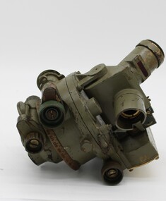 National Vietnam Veterans Museum (NVVM)
Equipment - Dumpy level in case
Standard issue item as used by Australian servicemen during the Vietnam conflict (1962-1972). This level was first issued for use in WW2.Khaki metal instrument with lens-viewfinder and numbers on circular range finding wheels. Object is stored in a khaki metal box with canvas carry straps. Inside the box, attachments prevent it from slipping. red label attached to strap says the object cannot be repaired.place/date/McBc = GdBg/ McB6 = GdBg/ BuBl COR. Inside box: scientific instruments MFGI and Repair Co. Pty Ltd/ 573 Burwood Road, Hawthorn 815527surveying tool, dumpy level, survey, surveyor, level