Showing 1031 items
matching the storm
-
 Flagstaff Hill Maritime Museum and Village
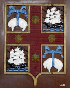
Plaque - Insignia, Bank of Australasia, 16-10-1980
This plaque displays the Bank of Australia's Coat of Arms and is significant because is ts the symbol printed on the Bank Notes of the Bank of Australasia. The bank of Australasia was incorporated by Royal Charter of England in March 1834. It had its Australian beginning on 14th December 1835, opening in Sydney. The Acting Superintendent of the bank at that time was David Charters McArthur. He was Superintendent from 1867-to 1876. The Melbourne branch opened on 28th August 1838 in a two-roomed brick cottage on the north side of Little Collins Street, where two huge mastiff dogs were used at night to guard the bank. The government also provided an armed military sentinel. Due to the bank's rapid growth, a new building for the Melbourne branch was opened in 1840 at 75 Collins Street West. By 1879 the bank had been upgraded to a magnificent two-storey building on the corners of Collins and Queens Streets, with the entry on Collins Street. In 1951 the Bank of Australasia amalgamated with the Union Bank to form the Australia and New Zealand Bank, now known as the ANZ. Then in 1970, the ANZ merged with both the ES&A and the London Bank of Australia to form the ANZ Banking Group Limited. The ANZ Banking Group Ltd kindly donated a variety of historic items from the Bank of Australasia. BANK of AUSTRALASIA, WARRNAMBOOL – In 1854 Warrnambool had two banks, the Union Bank and the Bank of Australasia. Later, completely different bank businesses opened; in 1867 the National Bank of Australasia, then in 1875 the Colonial Bank of Australasia. The original Warrnambool branch of the Bank of Australasia was established in July 1854, and operated from a leased cottage on Merri Street, close to Liebig Street. The bank next bought a stone building previously erected by drapers Cramond & Dickson on the corner of Timor and Gibson Streets. Samuel Hannaford was a teller and then Manager at the Warrnambool branch from 1855 to 1856 and the Warrnambool Council chose that bank for its dealings during 1856-57. In 1859 Roberts & Co. was awarded the contract to build the new Bank of Australasia branch for the sum of £3,000; the firm built the Warrnambool Post Office in 1856 and purchased land in Timor Street in 1858. The land was on a sand hill on the northeast corner of Timor and Kepler Streets and had been bought in 1855 from investor James Cust. The new building opened on May 21, 1860. The bank continued to operate there until 1951 when it merged with the Union Bank to form the ANZ Bank, which continued operating from its Liebig Street building. Warrnambool City Council purchased the former Bank of Australasia building in 1971 and renovated it, then on 3rd December 1973 it was officially opened as the Art Gallery by Cr. Harold Stephenson and Gallery Director John Welsh. The Gallery transferred to the purpose-built building in Liebig Street in 1986 and the old bank building is now the Gallery club. Staff at the Bank of Australasia in Warrnambool included the following men but others were also involved: Samuel Hannaford, Teller then Manager from 1855-1856; Hawkins, Manager in 1856, W H Palmer, Manager from January 1857 until November 1869 when the Teller Basil Spence was promoted to Manager; H B Chomley, Manager from April 1873 and still there in 1886; A Butt, Manager in 1895-1904; J R McCleary Accountant and Acting Manager for 12 months, until 1900; A Kirk, Manager 1904; J Moore, staff until his transfer to Bendigo in December 1908; J S Bath was Manager until 1915; C C Cox, Manager until April 1923; Richard C Stanley, Manager 1923 to April 1928. The plaque with the insignia has significance through its association with the Bank of Australasia. The early Australian bank was established in 1834 by Royal Charter and opened in Sydney, Australia, in Sydney in 1835. The bank had many Australian offices in November 1877, particularly on the east and south coasts. Victoria had 45 per cent of all Offices. The plaque is locally significant for its association with the Warrnambool Bank of Australasia, which was established in 1854. It was Warrnambool Council’s first bank. The bank continued to operate until the organisation's merger in 1951 when it became the ANZ Bank Group today. The Bank was an integral part of the growth of local commerce and the community.Insignia of the Bank of Australasia. Cast metal coat of arms within a gold, shield-shaped border, painted gold and red, with blue, black and white details. Decals in each corner; upper left and lower right have a white sheep suspended by a blue ribbon, upper right and lower left have a 3-masted, square-rigged sailing ship with a black hull and red flags flying on each mast, sailing on waves with storm clouds in the sky. Between the emblems are gold stars.Decals; ships, sheep, starsflagstaff hill, warrnambool, shipwrecked coast, flagstaff hill maritime museum, maritime museum, shipwreck coast, flagstaff hill maritime village, great ocean road, bank of australasia, boa, union bank, australia & new zealand bank, anz bank, david charters mcarthur, d c mcarthur, currency, banknote, commerce, banking, heraldic shield, insignia, samuel hannaford -
 Bendigo Historical Society Inc.
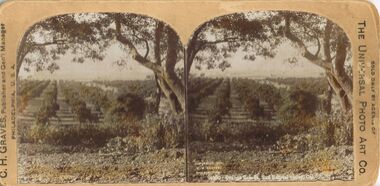
Photograph - HARRIS COLLECTION: STEREOSCOPIC VIEWS, Nineteenth Century
Stereoscopic Views. Printed on Front. C H Graves Publisher and General Manager Philadelphia, U S A, The Universal Photo Art Co. Reverse circular stamp contains, W E Bell Sole Agent Penshurst N S W.. 1. Orange Groves San ??. 2. The Coming Storm, Lake Erie. Stamped reverse. G J Williams, Merchant, Eaglehawk. W.E. Bell sole Agent Penshurst N.S.W. 3. Jesus Condemned to Death.The Universal Photo Art Copostcard -
 Nillumbik Shire Council
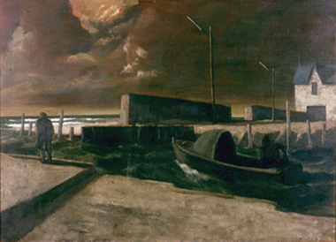
Painting: Rick AMOR (b.1948, Melb. AUS), Rick Amor, Out to Sea, 1993
Rick Amor was a good friend of three times Archibald Prize winner Clifton Pugh, living and working at Pugh's artist colony Dunmoochin, (Cottles Bridge) during the 1980-1990s. Amor made frequent outdoor painting trips with Pugh. His studies of Williamstown and areas around the port fuelled a period of sustained painting in his studio at Dunmoochin. Amor is an artist of national significance who had lived locally in Dunmoochin (Cottles Bridge) during the time of this work's making. This painting was exhibited/entered into the 1993 Shire of Eltham Art Awards. The work is representative of Amor's style and interest in seascapes as subject matter. Oil on linen, seascape painting. A solitary and motionless male figure in an overcoat stands at the edge of a dock/jetty with his hands in his pockets looking out to sea with his back towards the viewer. A motorised boat is moored close by and a white house with a blue roof can be seen in the distance. The figure is engulfed by the landscape and a resounding sense of desolation. A storm is brewing; the mood forecast by dark, heavy and thick ominous clouds, alternately darkening with the approach of night, a polluted haze and rough seas. In red paint, lower right, signed 'RICK AMOR '93'amor, seascape, painting, personal, boat, dramatic, atmospheric, ekphrasis 2015, dunmoochin -
 Ballarat Tramway Museum
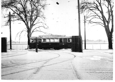
Photograph - Black & White Photograph/s - set of 3, Charles Craig, 1971
Yields information about an heavy hail storm in event on the Friday afternoon before the closure of the Victoria St line and the depot appearance at the time.Set of three Black and White photographs of trams passing or at the depot after the big hail storm on Friday afternoon 21/8/1971. .1 - No. 27 in Wendouree Parade, west bound. .2 - No. 42 entering the depot - tram has the destination of Mt Pleasant and has a SEC Briquettes roof advert. .3 - Scrubber in the depot yard. Photo by Charles Camera, at the time of the first closure of the Ballarat system, 23/8/1971 when the Victoria St line closed. trams, tramways, depot, closure, wendouree parade, tram 27, tram 42, scrubber -
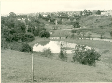 Darebin Parklands Association
Rockbeare Park and Darebin Creek, August 1974, 1974
In 1972 Ivanhoe Progress Association planned to fill in the wetlands because they felt it bred mosquitos, and they obtained a grant for this work to take place. Darebin Parklands Association stormed the meeting to get this decision reversed, and the wetlands were never filled in.B&W photograph. Shows wetlands and Darebin Creek. Albion Reid land on fore bank. View from the north with panorama of Kew in the distance This item and all other Darebin Parklands Association archival material is now held by State Library Victoria (Accession No: YMS 13746). Please contact State Library Victoria if access is required. -
 Greensborough Historical Society
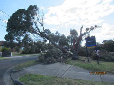
Photograph - Photograph - Digital Image, Peter Simmenauer, Storm damage, Barclay Park 2021, 27/10/2021
Storm damage incurred on night of 27-28/10/2021 at Barclay Park, cnr. Mackenzie Street & Plenty Lane, Greensborough. SES have lopped some of the dangerous tree limbs, but some are still resting on electric and communication wiring. Colour digital photographDate stamped: 31/10/2021barclay park, mackenzie street greensborough, plenty lane greensborough, storm damage -
 Greensborough Historical Society
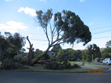
Photograph - Photograph - Digital Image, Peter Simmenauer, Storm damage, Barclay Park 2021, 27/10/2021
Storm damage incurred on night of 27-28/10/2021 at Barclay Park, cnr. Mackenzie Street & Plenty Lane, Greensborough. SES have lopped some of the dangerous tree limbs, but some are still resting on electric and communication wiring. Colour digital photographDate stamped: 31/10/2021barclay park, mackenzie street greensborough, plenty lane greensborough, storm damage -
 Greensborough Historical Society
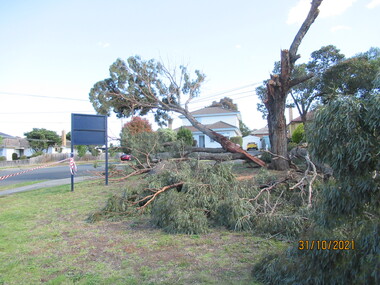
Photograph - Photograph - Digital Image, Peter Simmenauer, Storm damage, Barclay Park 2021, 27/10/2021
Storm damage incurred on night of 27-28/10/2021 at Barclay Park, cnr. Mackenzie Street & Plenty Lane, Greensborough. SES have lopped some of the dangerous tree limbs, but some are still resting on electric and communication wiring. Colour digital photographDate stamped: 31/10/2021barclay park, mackenzie street greensborough, plenty lane greensborough, storm damage -
 University of Melbourne, Burnley Campus Archives
Photograph - Black and white print, Plant Research Institute, 1932
Note by T.H. Kneen 19 November 1991, "The two trees beyond the P.R.L. Are Eucalyptus camaldulensis(Red Gum) and the nearer and taller of the two was severely damaged by a storm (mid fifties). The other tree has survived and is a very good specimen."Black and white photograph. View of rear of Plant Research Institute/Laboratory (PRI/PRL), glasshouse and circular bed.On reverse, "Plant Research Laboratory, Glasshouse & Back Entrance to P.R.L. Dec 1932," signed by A.W. Jessep.plant research laboratory, prl, glasshouse, a.w. jessep, plant research institute, pri, trees, eucalyptus camaldulensis, department of agriculture victoria -
 Sunbury Family History and Heritage Society Inc.
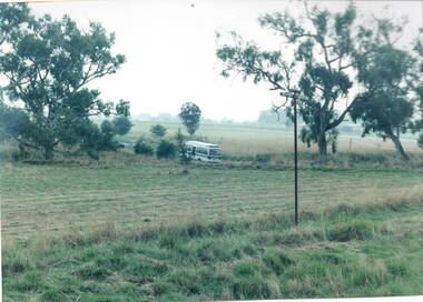
Photograph, Gellibrand Hill
After a day at Gellibrand Hill where the students from Bulla Primary School were engaged in tree-planting and being shown around the park, they were driven back to school in their small school bus in a very sudden rain storm.A non-digital photograph of a small bus driving out of a natural parkland.gellibrand hill, school excursions, bulla primary school -
 Dandenong/Cranbourne RSL Sub Branch
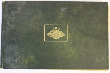
Book, "The Changing of the Guard"
Pictorial record of incidents that occurred during both World WarsLarge Green Leather covered book with Gold Australian Coat of Arms on front.Reproduced from Official and other photographs of the two World Wars. Published under the auspices of the Board of Management of the Australian War Memorial. Contains Dedication - To the men and women of the Empire who in every hour of danger , face the storm … who in their willing sacrifice are bearing the brunt of a struggle for the peace and security of all peoples.world war 1, ww1, world war one, world war 2, ww2, world war two -
 Port Fairy Historical Society Museum and Archives
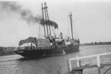
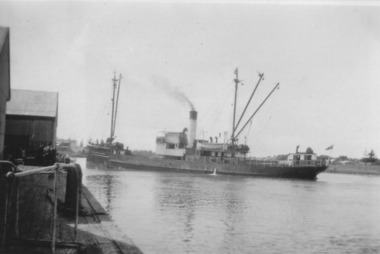
Photograph, TSS Coramba with record wool cargo
Owned by the Belfast & Koroit Steamship Co. Used primarily for shipping freight between Port Fairy and Melbourne, the Coramba was lost off Phillip Island during a storm on 30th November 1934. Her location was not discovered until 29th May 2011B&W photographship, boat, sea, river -
 Lakes Entrance Regional Historical Society (operating as Lakes Entrance History Centre & Museum)
Photograph - Lake Tyers, Marie Fish, 1978
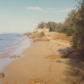
Two other colour photographs taken of damage from storms June/July 1978 showing that sand dune between lake and ocean was swept away, road and toilet block undermined numbers 03831.1 and 3831.2 size 9 x 8.5 cmColour photograph showing damage to shore and track to entrance at Lake Tyers Beach Victoriabeaches, waterways -
 Ballarat Tramway Museum
Photograph - Digital image Set of 2, 20/08/1971 12:00:00 AM
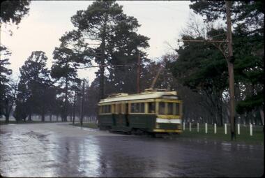
Yields information about the SEC Ballarat trams in the months before the closure of the SEC Tramway system. Yields information about the streetscape. Digital images, scanned from slides by Graeme Cleak, scanning by Peter Winspur 9/2011. .1 - Slide FR29, of a bogie car, leaving the loop northbound in heavy rain - photo blurred. .2 - Slide FR31, of No. 41, bound for Mt Pleasant, at Sturt and Lydiard Streets, with passenger boarding and a newspaper boy on the left hand side standing behind the tram. A heavy rain storm has just occurred. Has the ANZ bank and the Post Office in the background. Both photos 20-8-1971 trams, tramways, sturt st, lydiard st, gardens loop, tram 41 -
 Moorabbin Air Museum
Manual (Item) - RAAF Bairnsdale: The Story Of A Wartime Airfield
Description: 73 pages. Published by United States Dept of Navy. Published 1/1/1944. Tech Order 30-100D -1. Technical Lessons in All Weather Aspects - Ice, Turbulence, Fog, Storm, Cold/Warm Fronts. Level of Importance: World. -
 Bendigo Historical Society Inc.
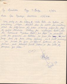
Document - ARTICLES FOR ROYAL HISTORICAL SOCIETY (BENDIGO BRANCH) NEWSLETTER APRIL 1973
Articles for Royal Historical Society (Bendigo Branch) Newsletter - April 1973. 1. From Bendigo Advertiser 15/10/1950 re Bendigo's first unofficial postman, Mr Collier, White Hills. 2.''Inaugurating the New Lock Up'' from Bendigo Advertiser 20/9/1861; mention of Detective Thompson and first inhabitant of Market Square lockup (man named Diamond). 3. Chinese Testimonial (Bendigo Advertiser 27/11/1856) re ring presented to Mr Lysaght as their ''first lawyer''. 4. Bendigo City Coat of Arms - description of this in detail and the representations of the Coat of Arms that are incorrect (eg on three sides of the City Hall) Suggestion - '' see the old Council Chambers'' for ''portraits'' of the (full and correct?) Bendigo Coat of Arms.5. Article from Bendigo Advertiser 4th Jan 1864 re storm of 31/1/1864 (sic) December? Mention of Axe Creek Bridge Hotel of Mr Costelloe. A note from 1973 from author that this hotel might later have been renamed 'The Perseverance' hotel; details of severed storm and flash flood of the day. [Two copies].document, names of bendigo pioneers, bendigo -
 Port of Echuca
Photograph, Original photo c.1920
The iron bridge was completed in 1878 and was used by the Deniliquin and Moama Railway company for goods trains only - it was another year before passengers were included in the transport service. On 4 March 1879 citizens of Echuca and Moama stormed the bridge, opened the gates and declared it open for their use.At the turn of the century the railway line carried produce from southern New South Wales & the Riverina to Melbourne, with goods trains being a very important mode to transport. When the bridge was being constructed, six workmen were killed and another maimed when a pile on the Moama bank collapsed. After the storming of the bridge by local people in March 1879 it was declared open for use of local residents traveling between the towns of Echuca and Moama. The bridge was shared by rail, road and pedestrian traffic.An image of the iron bridge at Echuca, taken looking East from Victoria bank.Verso: "Iron bridge"murray river bridge , echuca, murray bridge, echuca, iron bridge, echuca -
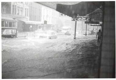 Melbourne Tram Museum
Photograph - Elizabeth St floods - Lonsdale St, Keith Kings, 17-2-1972
Photos shows the severity of the water washing down Elizabeth St following a major storm. Taken at or near the corner with Lonsdale St. In the second photo, W5 793, route 54, surrounded by water. Note the fruit vendors cart has crashed into a parked VW beetle.Yields information about a major rain event in Elizabeth St during 1972 and the impact it had on vehicles and tramway operations. Set of two Photographs - Elizabeth St floods - near Lonsdale St 1972Detailed description on rear. K S Kings stamp. tramways, flooding, floods, elizabeth sreet, events -
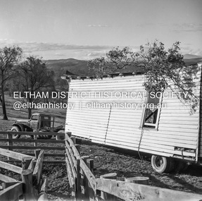
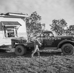 Eltham District Historical Society Inc
Negative - Photograph, J.A. McDonald, Removal of the remains of the Abraham house at Kangaroo Ground, c. May 1962
Martin Bros House Removing of Seaford was contracted to remove the remains of the storm damaged Abraham house from the property circa May 1962. The Abraham family owned land near the Aqueduct and east of Nicholas Lane at Kangaroo Ground (based on photos, at or near 40 Nicholas Lane).Record of various Shire of Eltham infrastructure works undertaken during the period of 1952-1962 involving bridge and road reconstruction projects, sometimes with Eltham Shire Council Project Reference numbers quoted. It was during this period that a number of significant improvements were made to roads and new bridges constructed within the shire that remain in place as of present day (2022). In many situations, the photos provide a tangible visible record of infrastructure that existed throughout the early days of the Shire. The album was put together by or under the direction of the Shire Engineer, J.A. McDonald.1962-05, abraham house, kangaroo ground, martin bros house removing seaford, nicholas lane, property damage -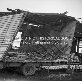
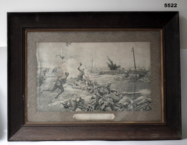 Bendigo Military Museum
Print - PEN & INK PRINT, FRAMED, Walsh's Portrait Printers and Enlargers, "Saving Amiens", c1918-1930
The owner was John Conrad Brown NR 706 of the 38 Bn. He was severely wounded in action (GSW to face and left arm). He returned to Australia and was pensioned off. The owner had this artwork in his house at Goornong until a storm blew the roof off. It was important to him.This is a large black and white print depicting a scene in the Amiens battle. It shows Australian and German men fighting. A small stone bridge is near the centre of the work. High explosive blasts are depicted in the picture. It is finely detailed i.e. buttons on uniforms and dovetail joints in the ammunition box. It is set in a thick card mat. Under the image is the caption. The frame is a simple heavy timber type. The rear has a paper cover but is broken away.The artist was F. Matania. (Fortunino Matania)ww1, amiens, 9 brigade, framed print -
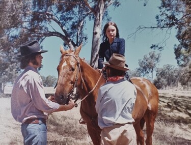 Wodonga & District Historical Society Inc
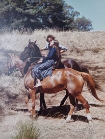
Album - Ringer's River by Des Martin - Plate 27 - Erin swims the river with a warning
Erin swims the river when she finds herself too late to reach the drovers before their crossing; and amazes O'Day and Keiran when she arrives with the news that the police have them cut off. Behind her a major storm up river is causing the water to rise.The album and images are significant because they document literature written by a prominent member of the Wodonga community. The presentation of this precis was supported by several significant district families and individuals.Ringer's River Album Coloured photo Plate 27des martin, many a mile, ringer's river, northeast victoria stories -
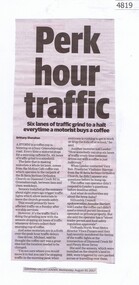 Greensborough Historical Society
Newspaper Clipping, Diamond Valley Leader, Perk hour traffic, 30/08/2017
A storm in a coffee cup is brewing on busy Diamond Creek Road. Every time a motorist stops for a morning caffeine fix, six lanes of traffic grind to a standstill. Sensors installed at St Sava Serbian Church trigger traffic lights which allow the car in the carpark to enter traffic.News article 1 page, black text.greensborough, coffee stop, diamond creek road, nillumbik council, st sava serbian orthodox church -
 Rutherglen Historical Society
Image, c April 1958
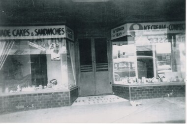
Booklet - Rutherglen heritage walk : a self-guided tour of Rutherglen's Historic Streetscapes / by Rutherglen Wine Experience. 2009, p. 5 - states that the Red Boot Shop was "demolished sometime after WWII, and no trace remained until a wild storm uncovered the tiled entrance in the mid 2000's."Black and white photograph of the front of a café, with a central door flanked by two display windows. In tile, in front of the door, is the sign "The Red Boot Shop".On back of photo: "Ozone Café Main St Rutherglen | approx. April 1958 | purchased by Harold Hall March 1958 from McKinlays. | owners after H. Hall | McCarthy | Alan Zotti"main street rutherglen, red boot shop, ozone cafe, harold hall, alan zotti, mccarthy -
 Port Fairy Historical Society Museum and Archives
Photograph, TSS Coramba
Used primarily for shipping freight between Port Fairy and Melbourne, the Coramba was lost off Phillip Island during a storm on 30th November 1934. Her location was not discovered until 29th May 2011. This photograph is unique because it shows the ship using the turning basin in the Moyne River.B&W photograph ship, boat, sea, river -
 Wodonga & District Historical Society Inc
Album - Ringer's River by Des Martin - Plate 28 - Proposal and escape
Refusing to risk bloodshed in a clash with the police, O'Day decides to swim all the cattle back to N.S.W. before the storm breaks. He and Erin are the last to enter the water. Before they do so he reaches out for her, asks her to marry him, and kisses her fiercely before the horses plunge apart.The album and images are significant because they document literature written by a prominent member of the Wodonga community. The presentation of this precis was supported by several significant district families and individuals.Ringer's River Album Coloured photo Plate 28des martin, many a mile, ringer's river, northeast victoria stories -
 Bendigo Historical Society Inc.
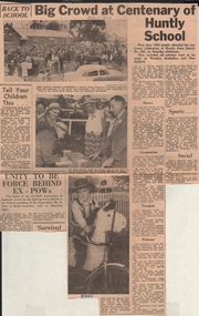
Newspaper - LYDIA CHANCELLOR COLLECTION: CENTENARY OF HUNTLY PRIMARY SCHOOL
Although opened by the Church of England in 1857, Huntly was not recognised as beginning until 1860 when it began to receive government funding. In 1862 it became known as a Common School. In the 1870's it was partly destroyed in a wind storm and a brick building was built to replace it. It became a State School between 1873 and 1878 and was renamed Huntly Primary School in 1970.Newspaper article, June 13, 1960 Bendigo Advertiser, describing the activities held at the Hunty Primary School Centenary celebrations. 'More than 1000 people attended the centenary celebration of Huntly State School 306' Images: attendees in front of school building,; an old pupil Mrs. A. Fleming signing the school roll and Trevor Willman, with his decorated bicycle.education, primary, huntly primary school