Showing 309 items matching "tourist attractions"
-
 Marysville & District Historical Society
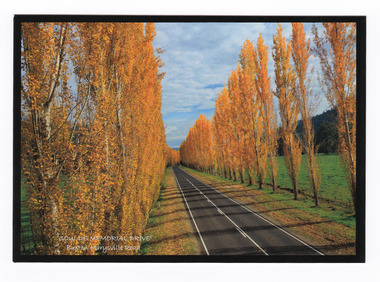
Postcard (item) - Colour postcard, Donovan Wilson, 'GOULDS MEMORIAL DRIVE'- Buxton Marysville Road, Post 2009
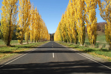
... yellow and are a major tourist attraction. This postcard ...A colour photograph taken of Gould Memorial Drive on the Buxton Marysville Road in Victoria.A colour photograph taken of Gould Memorial Drive on the Buxton Marysville Road in Victoria. The planting of the avenue of Lombardi Poplars was initiated by Mrs Joy Gould and the trees were planted by workers of the Gould Mill. The intention was for the avenue to extend from Marysville to Buxton. However, this was never fully realised. In Autumn the trees turn a brilliant yellow and are a major tourist attraction. This postcard was produced by Donovan Wilson Photography as a souvenir of Marysville.Gould Memorial Drive/ Buxton Marysville Road/ Marysville Donovan Wilson/ Photography Place/ Stamp/ Heremarysville, buxton, poplar trees, gould memorial drive, donovan wilson, postcard, souvenir, marysville-buxton road -
 Marysville & District Historical Society
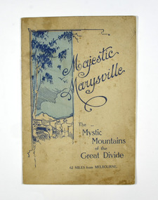
Booklet, Marysville Tourist Association, Magestic Marysville-The Mystic Mountains of the Great Divide, 1920's
An information guide of day trips to attractions in and around Marysville in Victoria. This booklet was produced by the Marysville Tourist Association.Paperback. Cover is beige with a drawing of two people standing next to a car looking at the view. The title is in dark blue across the front.non-fictionAn information guide of day trips to attractions in and around Marysville in Victoria. This booklet was produced by the Marysville Tourist Association.marysville, victoria, marysville tourise association, steavenson falls, keppel falls, cameron cascades, cumberland, mt cathedral, eildon, snob's creek falls, wolfram mine, mt strickland, keppel's lookout, mt kitchener, mt edgar, mt gordon, nichol's lookout, michael dene, beauty spot, gilbert's gully, taggerty river, wood's point -
 Marysville & District Historical Society
Flyer (item) - Brochure, Artworkz Tourism, Marysville-Steavenson Falls, 2018
A brochure including photographs and a tourist map of Marysville and some of the area's attractions focusing on Steavenson Falls. A brochure including photographs and a tourist map of Marysville and some of the area's attractions focusing on Steavenson Falls. The Steavenson Falls is named after the Victorian Assistant Commissioner of Roads and Bridges, John Steavenson who arrived in Victoria in the early 1860s.Shadowed by over 30 Mountains and/ on the banks of the beautiful Goulburn River/ and Lake Eildon. This is our playground.marysville, steavenson falls, victoria, waterfalls, john steavenson -
 Marysville & District Historical Society
Photograph (Item) - Colour photograph, Unknown
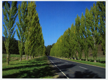
... . In Autumn the trees turn a brilliant yellow and are a major tourist ...A colour photograph of Gould Memorial Drive which is on the Marysville-Buxton Road near Marysville in Victoria.A colour photograph of Gould Memorial Drive which is on Marysville-Buxton Road just outside Marysville in Victoria. The planting of the avenue of Lombardi Poplars was initiated by Mrs Joy Gould and the trees were planted by workers of the Gould Mill. The intention was for the avenue to extend from Marysville to Buxton. However, this was never fully realised. In Autumn the trees turn a brilliant yellow and are a major tourist attraction. john lloyd gould, joy gould, gould mill, gould memorial drive, marysville-buxton road, marysville, buxton, victoria, photograph, lombardi poplars -
 Marysville & District Historical Society
Photograph (Item) - Colour photograph, Unknown
... . In Autumn the trees turn a brilliant yellow and are a major tourist ...A colour photograph of Gould Memorial Drive which is on the Marysville-Buxton Road near Marysville in Victoria.A colour photograph of Gould Memorial Drive which is on Marysville-Buxton Road just outside Marysville in Victoria. The planting of the avenue of Lombardi Poplars was initiated by Mrs Joy Gould and the trees were planted by workers of the Gould Mill. The intention was for the avenue to extend from Marysville to Buxton. However, this was never fully realised. In Autumn the trees turn a brilliant yellow and are a major tourist attraction. john lloyd gould, joy gould, gould mill, gould memorial drive, marysville-buxton road, marysville, buxton, victoria, photograph, lombardi poplars -
 Marysville & District Historical Society
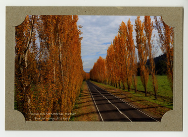
Photograph (item) - Colour photograph, Donovan Wilson, 'GOULDS MEMORIAL DRIVE'- Buxton Marysville Road, Post 2009
... yellow and are a major tourist attraction. marysville buxton ...A colour photograph taken of Goulds Memorial Drive on the Buxton Marysville Road in Victoria.A colour photograph taken of Goulds Memorial Drive on the Buxton Marysville Road in Victoria. The planting of the avenue of Lombardi Poplars was initiated by Mrs Joy Gould and the trees were planted by workers of the Gould Mill. The intention was for the avenue to extend from Marysville to Buxton. However, this was never fully realised. In Autumn the trees turn a brilliant yellow and are a major tourist attraction. marysville, buxton, poplar trees, gould memorial drive, donovan wilson, postcard, souvenir, marysville-buxton road -
 Marysville & District Historical Society
Photograph (Item) - Colour photograph, Unknown
... yellow and are a major tourist attraction. john lloyd gould joy ...A digital copy of a colour photograph of Gould Memorial Drive which is on the Marysville-Buxton Road near Marysville in Victoria.A digital copy of a colour photograph of Gould Memorial Drive which is on Marysville-Buxton Road just outside Marysville in Victoria. The planting of the avenue of Lombardi Poplars was initiated by Mrs Joy Gould and the trees were planted by workers of the Gould Mill. The intention was for the avenue to extend from Marysville to Buxton. However, this was never fully realised. In Autumn the trees turn a brilliant yellow and are a major tourist attraction. john lloyd gould, joy gould, gould mill, gould memorial drive, marysville-buxton road, marysville, buxton, victoria, photograph, lombardi poplars -
 Marysville & District Historical Society
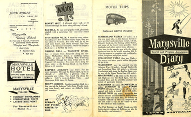
Ephemera (Item) - Programme of events, Marysville Tourist & Progress Association, Marysville Tourist and Progress Association Diary, 1963
A programme of events taking place in January, 1963, published by the Marysville Tourist and Progress Association. 1963 was Marysville's centenary year. The Association was formed in November 1907 to promote tourism within the area. This included the physical creation of signage, parklands, roads and walks to various attractions. A programme of events taking place in January, 1963, published by the Marysville Tourist and Progress Association. 1963 was Marysville's centenary year.marysville, victoria, programme, marysville tourist and progress association, misslynn beauty salon, marysville garage, crossways cabaret, l.h. potter, marysville swimming pool, regal squab farm, bartons stores, fruit salad farm, percy postlethwaite, jock roofe taxi service, the marysville riding school, marysville hotel, marysville theatre, cumberland valley, steavenson falls, warburton, healesville, alexandra, mansfield, jamieson, wood's point, eildon weir, snob's creek, rubicon, beauty spot walk, red hill walk, wishing well, taggerty river, keppel's lookout, mount gordon -
 Marysville & District Historical Society
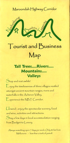
Map (Item) - Tourist and business map, Narbethong Community and Tourism Group, Narbethong Buxton Taggerty Tourist and Business Map, 04-2008
A tourist and business map of Narbethong, Buxton and Taggerty. This map was produced by the Narbethong Community and Tourism Group in April 2008. It was produced to promote the natural attractions, adventure activities and food trail from the Black Spur, through Narbethong, Buxton and Taggerty.A tourist and business map of Narbethong, Buxton and Taggerty.This publication has been produced by the Narbethong Community and Tourism/ Group (NCTG) to promote the natural attractions, adventure activities and food/ trail from the Black Spur, through Narbethong, Buxton and Taggerty./ the information provided in this publication has been supplied by the individual/ members. NCTG takes no responsibility for its accuracy./ April 2008narbethong, buxton, taggerty, victoria, australia, tourist and business map, narbethong community and tourism group, acheron valley, yarra track, wood's point, black spur, mystic mountains, the meeting of the waters, cathedral range, danico design counted cross stitch, things of sand & stone, buxton zoo nursery & oddz & enz, willowbank at taggerty, safe trek 4wd services, pnl 4wdriving, buxton trout and salmon farm, mystic mountains ski hire & outdoors, narbethong ski hire, highwood health centre, cathedral view natural therapies, narby cabinets, plants by shelian, gb timber, executive signs, rb automotive repairs, buxton car care, marysville towing & equipment hire, martyn slade building design, cathedral peak framing, black spur roadhouse & ski hire, tudor lodge roadhouse & ski hire, buxton roadhouse & persian bazzar, buxton post office general store & niche bar, igloo roadhouse, taggerty store, narby eggs, marapana agistment park, mantirri blueberry farm, carmyle farm, hazelwood hazelnuts, south cathedral lavender farm, cathedral cherries, black spur motel & caravan park, woodlands rainforest retreat, chestnut glade, black spur inn, wombat cottage, abbey lake luxury b & b spa cottages, blue views holiday cottages, camp narbethong, marapana farm stay b & b, mantirri blueberry farm b & b, little dene garden cottages, silverstream b & b cottages, nareen cabins, moondai farm b & b, south cathedral farm luxury b & b cottages, yarrolyn caravan park, sarsens rest, lomah retreat, pinjarra gardens, kingbilli country estate, henry viii manor house, buxton hotel, butters cafe of buxton, wagtail wines, little river wines, lanterns at willowbank, wirrawilla rainforest walk, wilhemina falls, the cascades -
 Marysville & District Historical Society
Map (Item) - Tourist and business map, Narbethong Community and Tourism Group, the Gateway TOURIST AND BUSINESS MAP, 08-2009
A tourist and business map of Narbethong, Buxton, and Taggerty. This map was produced by the Narbethong Community and Tourism Group Inc in August 2009. It was produced to promote the natural attractions, adventure activities, and food trail from the Black Spur, through Narbethong, Buxton, and Taggerty.A tourist and business map of Narbethong, Buxton and Taggerty.This publication has been produced by the Narbethong Community and Tourism Group Inc./ (NCTG) The information provided in this publication has been supplied by the individual/ members. NCTG takes no responsibility for its accuracy./ August 2009narbethong, buxton, taggerty, victoria, australia, tourist and business map, the gateway tourist and business map, black spur motel & caravan park, woodlands rainforest retreat, chestnut glade, black spur inn, wombat cottage, abbey lake luxury b&b spa cottages, camp narbethong, marapana farm stay b&b, mantirri b&b, little dene garden cottages, nareen cabins, silverstream b&b cottages, buxton hotel motel, south cathedral farm luxury b&b cottages, cathedral view b&b retreat, kingbilli country estate, cathedral valley farm, pinjarra gardens, willowbank at taggerty, sarsens rest, yarrolyn caravan park, danico design counted cross stitch, things of sand & stone, buxton zoo nursery, safetrek 4wd services, mystic mountains ski hire & outdoors, pnl 4wdriving, buxton trout and salmon farm, buxton bait and tackle, black spur roadhouse, tudor lodge service station roadhouse & ski hire, buxton roadhouse, buxton p.o. general store, igloo roadhouse, henry v111 manor house, buxton hotel, butters cafe, wagtail wines, little river wines, narby eggs, marapana agistment park, carmyle farm, hazelwood hazelnuts, cathedral view naturall therapies, cre8ing growth, linda hailey, naby cabinets, gb timber, narbethong timber & trading, rb automotive repairs, buxton car care, martyn slade building design, taggerty vet clinic -
 Marysville & District Historical Society
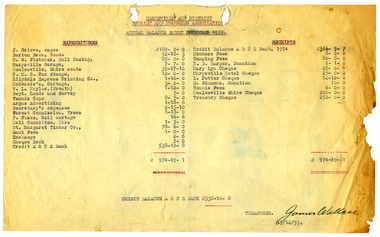
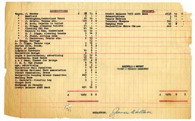
Ephemera (Item) - Annual Balance Sheet, James Wallace, Marysville and District Tourist and Progress Association-Annual Balance Sheet-December 1955, 15-12-1955
... and District Tourist and Progress Association-Annual Balance Sheet ...Marysville and District Tourist and Progress Association-Annual Balance Sheet-December 1955Marysville and District Tourist and Progress Association-Annual Balance Sheet-December 1955 The Association was formed in November 1907 to promote tourism within the area. This included the physical creation of signage, parklands, roads and walks to various attractions. TREASURER./James Wallace/ 15/12/55.marysville, victoria, marysville tourist & progress association, marysville and district tourist and progress association, annual balance sheet -
 Marysville & District Historical Society
Ephemera (Item) - Annual Balance Sheet, James Wallace, Unknown
... attractions. marysville victoria marysville tourist & progress ...Marysville and District Tourist and Progress Association-annual balance sheetMarysville and District Tourist and Progress Association-annual balance sheet The Association was formed in November 1907 to promote tourism within the area. This included the physical creation of signage, parklands, roads and walks to various attractions. TREASURER./James Wallacemarysville, victoria, marysville tourist & progress association, marysville and district tourist and progress association, annual balance sheet -
 Marysville & District Historical Society
Ephemera (Item) - Annual Balance Sheet, James Wallace, Unknown
... & District Tourist & Progress Association annual balance sheet ...Marysville & District Tourist & Progress Association annual balance sheetMarysville & District Tourist & Progress Association annual balance sheet The Association was formed in November 1907 to promote tourism within the area. This included the physical creation of signage, parklands, roads and walks to various attractions. TREASURER./James Wallacemarysville, victoria, marysville tourist & progress association, marysville and district tourist and progress association, annual balance sheet -
 Marysville & District Historical Society
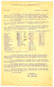
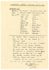
Ephemera (Item) - Circular, Jack Haycraft, Marysville Tourist & Progress Association, 17-15-1965
... Tourist & Progress Association requesting assistance from members ...A circular produced by the Marysville Tourist & Progress Association requesting assistance from members in raising funds to promote tourism in the district. This circular was sent to members in September 1965 to inform members as to which members had paid the requested funds, how much they had paid, and which members had outstanding payments still to be made. The circular was sent to encourage members to support the endeavour to raise funds to enable the town of Marysville to promote tourism in the district. A circular produced by the Marysville Tourist & Progress Association requesting assistance from members in raising funds to promote tourism in the district. The Association was formed in November 1907 to promote tourism within the area. This included the physical creation of signage, parklands, roads and walks to various attractions. marysville, victoria, marysville tourist & progress association, marysville and district tourist and progress association, circular -
 Marysville & District Historical Society
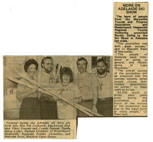
Newspaper (Item) - Newspaper article, Marysville Promotion Success, 1981
A newspaper article reflecting on the success of a display to promote Marysville and Lake Mountain. This display was the first of four displays over two weeks which was organised by Mrs. Connie Pannan from Nanda Binya Lodge in Marysville; Counselor Malcolm Reed from the Shire of Healesville and Marylyn Guest House in Marysville; Mrs. Val Cockerell from Blackwood Holiday Flats in Marysville; and Mr. Michael Cheshire from the Westernport Healesville Regional Tourist Authority. The display saw the release of a new full colour tourist brochure on Marysville produced with the co-operation of the Marysville Tourist and Progress Association and Westernport Healesville Regional Tourist Authority. It was deemed to be a most successful promotional event for Marysville and Lake Moutain.A newspaper article reflecting on the success of a display to promote Marysville and Lake Mountain. The Association was formed in November 1907 to promote tourism within the area. This included the physical creation of signage, parklands, roads and walks to various attractions. marysville, victoria, lake mountain, marysville tourist and progress association, newspaper article -
 Marysville & District Historical Society
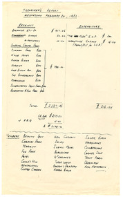
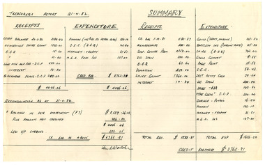
Ephemera (Item) - Treasure's Report, Treasurer's Report Wednesday February 24, 1982, 24-02-1982
Marysville Tourist & Progress Association-Treasurer's Report-February 24, 1982Marysville Tourist & Progress Association-Treasurer's Report-February 24, 1982 The Association was formed in November 1907 to promote tourism within the area. This included the physical creation of signage, parklands, roads and walks to various attractions. marysville, victoria, lake mountain, marysville tourist and progress association, treasurer's report -
 Marysville & District Historical Society
Ephemera (Item) - Treasure's Report, Ian R Walsh, Treasurer's Report 21.4.82, 24-02-1982
Marysville Tourist & Progress Association-Treasurer's Report-21.4.82. At the time of this report, Ian R. Walsh was the Treasurer of the Association.Marysville Tourist & Progress Association-Treasurer's Report-21.4.82. The Association was formed in November 1907 to promote tourism within the area. This included the physical creation of signage, parklands, roads and walks to various attractions. marysville, victoria, lake mountain, marysville tourist and progress association, treasurer's report -
 Marysville & District Historical Society
Ephemera (Item) - Treasure's Report, Ian R Walsh, Treasurer's Report - Thursday May 27, 1982, 24-02-1982
Marysville Tourist & Progress Association-Treasurer's Report-May 27, 1982. At the time of this report, Ian R. Walsh was the Treasurer of the Association.Marysville Tourist & Progress Association-Treasurer's Report-May 27, 1982. The Association was formed in November 1907 to promote tourism within the area. This included the physical creation of signage, parklands, roads and walks to various attractions. marysville, victoria, lake mountain, marysville tourist and progress association, treasurer's report -
Lorne Historical Society
Pamphlet - Tourist pamphlet Lorne, Lorne Victoria Australia
Victorian Railways printed a series of brochures publicizing holiday destinations.A folded paper souvenir pamphlet. The cover is a colored picture of Lorne from Scotsman’s Hill with two bathing suited young women in the foreground, and a blurb extolling the virtues of Lorne. On the back is a red, yellow and blue map of Lorne and district. Inside are eight black and white photographs of Lorne attractions,; the Main Street, tennis courts, Erskine River, walking tracks and the George River with the phrase ,” The resort that embraces everything for the perfect holiday.”souvenirs, pamphlets, victorian railways, -
Phillip Island and District Historical Society Inc.
Tourist leaflet
... of the Hotel. Also describes the attractions of the area. Tourist ...Leaflet advertising the San Remo Hotel and its amenities with a photograph of the Hotel and a description of the area.Leaflet advertising San Remo Hotel and its amenities with a photograph of the Hotel. Also describes the attractions of the area.local history, documents, commercial, documents, pamphlets, san remo hotel, tourist leaflet, san remo hotel -
Glenelg Shire Council Cultural Collection
Booklet - Brochure, Casterton, Focus of the South West, n.d
From the collection of Vanda Savill, Bower Bird Museum, Heywood 'Dear Friends' servesTourist brochure, 'Casterton Focus of the South-West. Single sheet glossy paper, folded in 4; mushroom coloured, black pen and ink image of Casterton Railway Station on front. Printed both sides with photos and descriptions of Casterton and District attractions, plus advertising.casterton, tourism, tourist information, advertising -
 Kiewa Valley Historical Society
Postcard Circa 1950, Lake Guy Dam and Bogong Village, Circa 1950
This postcard was produced in the 1950's for the tourist trade in the Kiewa Valley and Alpine region. It encompasses the period when the State of Victoria was pressured by the ever increasing demand by industry and its population for electricity supplies. Hydro electricity was seen as an untapped natural resource to quench this demand. The Victorian Alps and the rivers flowing into its valleys was ideal for the construction of the Kiewa Hydro Electricity Scheme. The late 1940's saw the development of this scheme and the changing of sections of alpine landscape is covered by this and other postcards/pictures (tourists, construction workers, and established rural populations). This period in time was before the established wildlife and forest/nature groups became political activist who changed legislative acts to protect the environment.This rural region (Kiewa Valley/alpine plains) was at most only significant to a smaller group of winter sports, summer hikers/horse riders and rural farmers/graziers. The numbers of tourists and the increase in the local resident population was boosted by the construction of the Hydro Electricity Scheme. This influx to the regional population resulted in a corresponding diversity in services and brought about an environment that responded to a growing level of tourists and thereby permitting this industry to grow more rapidly than it would have naturally. This postcard details an attraction to the "cleaner" method of providing electricity. This postcard was purchased in 1950 by a surveyor at Landford's Gap.This black and white photograph from a Valentine's postcard is from a V2 Argus photograph postcard. It is on a 200g/m paper density photo side gloss. See 0480 (B) - (F) for other photos of similar postcards.In white lettering " LAKE GUY & BOGONG VILLAGE KIEWA HYDRO-ELECTRIC PROJECT"kiewa valley tourism, victorian alps, alternate energy supplies, alpine population growth -
 Kiewa Valley Historical Society
Postcard Circa 1950, Snowfall at Bogong Village Kiewa Hydro-Electric Project, 1950s
This postcard was produced in the 1950's for the tourist trade in the Kiewa Valley and Alpine region. It encompasses the period when the State of Victoria was pressured by the ever increasing demand by industry and its population for electricity supplies. Hydro electricity was seen as an untapped natural resource to quench this demand. The Victorian Alps and the rivers flowing into its valleys was ideal for the construction of the Kiewa Hydro Electricity Scheme. The late 1940's saw the development of this scheme and the changing of sections of alpine landscape is covered by this and other postcards/pictures (tourists, construction workers, and established rural populations). This period in time was before the established wildlife and forest/nature groups became political activist who changed legislative acts to protect the environment.This rural region (Kiewa Valley/alpine plains) was at most only significant to a smaller group of winter sports, summer hikers/horse riders and rural farmers/graziers. The numbers of tourists and the increase in the local resident population was boosted by the construction of the Hydro Electricity Scheme. This influx to the regional population resulted in a corresponding diversity in services and brought about an environment that responded to a growing level of tourists and thereby permitting this industry to grow more rapidly than it would have naturally. This postcard details an attraction to the "cleaner" method of providing electricity. This postcard was purchased in 1950 by a surveyor at Landford's Gap.This scanned black and white photograph of a postcard, shows vehicles covered in thick snow at Bogong Village in 1950. See 0480(A), (C) - (F) for other similar photos of postcards available at this period."SNOWFALL AT BOGONG VILLAGE KIEWA HYDRO-ELECTRICITY PROJECT"kiewa valley tourism, victorian alps, alternate energy supplies, alpine population growth, bogong village, secv -
 Kiewa Valley Historical Society
Postcard Circa 1950, Scene in Bogong Village Kiewa Hydro-Electric Project, 1950s
This postcard was produced in the 1950's for the tourist trade in the Kiewa Valley and Alpine region. It encompasses the period when the State of Victoria was pressured by the ever increasing demand by industry and its population for electricity supplies. Hydro electricity was seen as an untapped natural resource to quench this demand. The Victorian Alps and the rivers flowing into its valleys was ideal for the construction of the Kiewa Hydro Electricity Scheme. The late 1940's saw the development of this scheme and the changing of sections of alpine landscape is covered by this and other postcards/pictures (tourists, construction workers, and established rural populations). This period in time was before the established wildlife and forest/nature groups became political activist who changed legislative acts to protect the environment. This rural region (Kiewa Valley/alpine plains) was at most only significant to a smaller group of winter sports, summer hikers/horse riders and rural farmers/graziers. The numbers of tourists and the increase in the local resident population was boosted by the construction of the Hydro Electricity Scheme. This influx to the regional population resulted in a corresponding diversity in services and brought about an environment that responded to a growing level of tourists and thereby permitting this industry to grow more rapidly than it would have naturally. This postcard details an attraction to the "cleaner" method of providing electricity. This postcard was purchased in 1950 by a surveyor at Landford's Gap. The couple shown in this photograph would have been employed by the S.E.C. under the Kiewa Hydro-Electricity Scheme.This item is a scanned black and white photograph of a couple walking along a gravel street in Bogong Village in 1950. See 0480 (A) ,(B), (D) - (F) for other photos of similar postcards" SCENE IN BOGONG VILLAGE KIEWA HYDRO-ELECTRIC PROJECT"kiewa valley tourism, victorian alps, alternate energy supplies, alpine population growth, bogong, secv -
 Kiewa Valley Historical Society
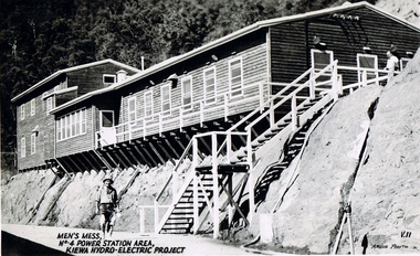
Postcard Circa 1950, Men's Mess No.4 Power Station, Kiewa Hydro-Electric Project
This postcard was produced in the 1950's for the tourist trade in the Kiewa Valley and Alpine region. It encompasses the period when the State of Victoria was pressured by the ever increasing demand by industry and its population for electricity supplies. Hydro electricity was seen as an untapped natural resource to quench this demand. The Victorian Alps and the rivers flowing into its valleys was ideal for the construction of the Kiewa Hydro Electricity Scheme. The late 1940's saw the development of this scheme and the changing of sections of alpine landscape is covered by this and other postcards/pictures (tourists, construction workers, and established rural populations). This period in time was before the established wildlife and forest/nature groups became political activist who changed legislative acts to protect the environment.Although this photo details the eating facilities of the construction workers at the power station it was not only a postcard for the people employed in the Hydro Scheme is was also provided to tourists visiting the area and thus used for promotional purposes.This rural region (Kiewa Valley/alpine plains) was at most only significant to a smaller group of winter sports, summer hikers/horse riders and rural farmers/graziers. The numbers of tourists and the increase in the local resident population was boosted by the construction of the Hydro Electricity Scheme. This influx to the regional population resulted in a corresponding diversity in services and brought about an environment that responded to a growing level of tourists and thereby permitting this industry to grow more rapidly than it would have naturally. This postcard details an attraction to the "cleaner" method of providing electricity. This postcard was purchased in 1950 by a surveyor at Landford's Gap. The men shown in this photograph would have been employed by the S.E.C. under the Kiewa Hydro-Electricity Scheme.This item is a scanned black and white photograph of a construction worker walking from stairs leading down from the men's mess building, in 1950. See 0480 (A) -(C), (E) - (F) for other photos of similar postcards"MEN'S MESS No.4 POWER STATION AREA, KIEWA HYDRO-ELECTRIC PROJECT" "ARGUS PHOTO V.IIkiewa valley tourism, victorian alps, alternate energy supplies, alpine population growth, secv -
 Kiewa Valley Historical Society
Postcard Circa 1950, Mt. Beauty Village, Kiewa Hydro-Electricity Project, circa 1950
This postcard was produced in the 1950's for the tourist trade in the Kiewa Valley and Alpine region. It encompasses the period when the State of Victoria was pressured by the ever increasing demand by industry and its population for electricity supplies. Hydro electricity was seen as an untapped natural resource to quench this demand. The Victorian Alps and the rivers flowing into its valleys was ideal for the construction of the Kiewa Hydro Electricity Scheme. The late 1940's saw the development of this scheme and the changing of sections of alpine landscape is covered by this and other postcards/pictures (tourists, construction workers, and established rural populations). This period in time was before the established wildlife and forest/nature groups became political activist who changed legislative acts to protect the environment. The regulatory pondage on the northern aspect of the village had no water over-spill from the unfinished power station.This rural region in 1950 (Kiewa Valley/alpine plains) was at most only significant to a smaller group of winter sports, summer hikers/horse riders and rural farmers/graziers. The numbers of tourists and the increase in the local resident population was boosted by the construction of the Hydro Electricity Scheme. This influx to the regional population resulted in a corresponding diversity in services and brought about an environment that responded to a growing level of tourists and thereby permitting this industry to grow more rapidly than it would have naturally. This postcard details an attraction to the "cleaner" method of providing electricity. This postcard was purchased in 1950 by a surveyor at Landford's Gap. The couple shown in this photograph would have been employed by the S.E.C. under the Kiewa Hydro-Electricity Scheme.This item is a scanned black and white photograph of a panoramic view of Mount Beauty Village in 1950 (a closed village, entry by pass only). The regulatory pondage has earthen walls but no water.See 0480 (A) -(D) and (F) for other photos of similar postcards"MT. BEAUTY VILLAGE KIEWA HYDRO-ELECTRIC PROJECT"kiewa valley tourism, victorian alps, alternate energy supplies, alpine population growth -
 Kiewa Valley Historical Society
Postcard Circa 1950, Howman Gap Hostel under snow Kiewa Hydro-Electric Project, Circa 1950
This postcard was produced in the 1950's for the tourist trade in the Kiewa Valley and Alpine region. It encompasses the period when the State of Victoria was pressured by the ever increasing demand by industry and its population for electricity supplies. Hydro electricity was seen as an untapped natural resource to quench this demand. The Victorian Alps and the rivers flowing into its valleys was ideal for the construction of the Kiewa Hydro Electricity Scheme. The late 1940's saw the development of this scheme and the changing of sections of alpine landscape is covered by this and other postcards/pictures (tourists, construction workers, and established rural populations). This period in time was before the established wildlife and forest/nature groups became political activist who changed legislative acts to protect the environment.This rural region (Kiewa Valley/alpine plains) was at most only significant to a smaller group of winter sports, summer hikers/horse riders and rural farmers/graziers. The numbers of tourists and the increase in the local resident population was boosted by the construction of the Hydro Electricity Scheme. This influx to the regional population resulted in a corresponding diversity in services and brought about an environment that responded to a growing level of tourists and thereby permitting this industry to grow more rapidly than it would have naturally. This postcard details an attraction to the "cleaner" method of providing electricity. This postcard was purchased in 1950 by a surveyor at Landford's Gap.This item is a scanned black and white photograph of a panoramic view of Howman Gap Hostel under snow in 1950 (a closed village, entry by pass only). This accommodation was for construction workers only. See 0480 (A) -(E) for other photos of similar postcards.On the photo, " Howman Gap Hostel under snow Kiewa Hydro-Electric Project" . On postcard address and personal information side "V.2 Valentine's Post Card "kiewa valley tourism, victorian alps, alternate energy supplies, alpine population growth, bogong, secv, howman's gap hostel -
 Kiewa Valley Historical Society
Photograph of Snow Covered Catchment Area Vic, Snow Covered Catchment Area Victorian Alps - 1950s, Circa 1950
This photograph details (early to mid1950s), the Victorian Alpine region when this remote area was part of a "lay back" rural landscape,occasionally visited by recreational adventurers and some wayward tourists. The mountain ranges had provided an adequate barrier against the way-would traveller, but with the opening up of this region by the provision of improved roadways and accommodation facilities, courtesy of the Kiewa Valley Hydro Electricity Scheme, changes such as tourism and its impact upon the "natural" state started to show its side effects (clearing of the land). The expansion of the European immigration numbers (1950s) coming into Australia was increasing after World War II which not only provided increased construction workers to the region but also immigrants who appreciated alpine regions. Some of these immigrants contributed to the expansion of the region and provided for a greater degree of diverse professions and rural related work force.This photograph depicts the borderline in time between an exclusively rural based population and respective activities(early 1900s)to the present (2000 on wards) integrated village, tourist and retiree/holiday area. The time when land was exclusively used in agriculture and Alpine grazing lands is over. The Kiewa Valley is loosing its hiding place and is becoming more and more a source of untapped residential land and winter time recreational adventure lands. The changes brought about by modern technologies involving recreational activities such as hang gliding, gliding (local airstrip), mountain bikes, car rallies and their associated clubs is providing for an increased short term population boost. These together with the attractions for retirees is changing not only the physical nature of the Kiewa valley but also its "soul".This item is a black and white photograph of a section of snow covered catchment area in the Victorian Alps in the mid 1900. It is on 200 gms paper but not on photographic paper and has a white boarder (3 mm).kiewa valley tourism, victorian alps, alternate energy supplies, alpine population growth -
 Kiewa Valley Historical Society
Folder - Bogong Village in c1997
... , especially those who worked and lived there. It is also a tourist ...Bogong Village was constructed in the early stages of the Kiewa Hydro Electric Scheme. Employees of the SECV lived there before the town of Mt Beauty was constructed in the late 1940s. By 1997 the village was owned by Southern Hydro who didn't want a 'non-core service' and wished to sell it.The history of Bogong Village is that of a construction town that no longer has a use for its owner. However, it has an emotional significance for people in the area, especially those who worked and lived there. It is also a tourist attraction and includes the Outdoor School - Bogong Campus which was called the Bogong Outdoor Education Centre in 1992. Its history began in 1968 when the Victorian Education Department acquired the camp buildings and four houses from the SECV. Blue plastic folder with black spiral binding with 12 back-to-back pages in plastic sleeves. It includes articles relating to the future of Bogong Village c1997.bogong village sale, southern hydro c1997