Showing 272 items matching "tourist map"
-
 Warrnambool and District Historical Society Inc.
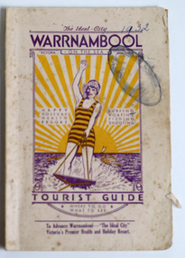
Booklet - Warrnambool Tourist Booklet, Warrnambool Progress Association, Warrnambool On the Sea, Victoria, Australia, Tourist Guide, 1932
Warrnambool Tourist GuideThis is a booklet with a cream cover featuring a sketch of a woman waterskiing and blue printing. The pages contain black and white photographs, advertisements, two maps and printed text. There is one fold-out page. The booklet is stapled and bound with glue.non-fictionWarrnambool Tourist Guidewarrnambool tourism, warrnambool progress association -
 Bendigo Historical Society Inc.
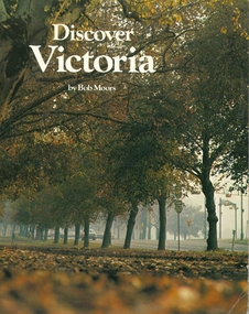
Book - DISCOVER VICTORIA, 1979
Discover Victoria by Bob Moors, soft cover 104 pages with maps, black and white & colour illustrations, published by Decalon Pty Ltd Melbourne. This book, with the compliments of The Department of State Development, Decentralization and Tourism is designed to introduce you to the many tourist attractions in the twelve regions of Victoria, the garden state.victoria, history, people and places in victoria. -
 Victorian Railway History Library
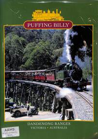
Book, Emerald Tourist Railway Board, Puffing Billy Dandenong Ranges Victoria Australia, 1998
A brief illustrated history of the 2'6" Puffing Billy railway from Upper Fern Tree Gully to Gembrook in Victoriaill, maps, p.32.non-fictionA brief illustrated history of the 2'6" Puffing Billy railway from Upper Fern Tree Gully to Gembrook in Victoriavr narrow gauge railways - victoria - history, puffing billy - victoria - history -
 Victorian Railway History Library
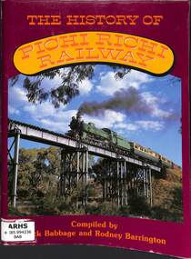
Book, Babbage, Jack, The History of Pichi Richi Railway, 1984
... Railways Great Northern Railway to a preserved steam tourist ...A history of the Pichi Richi railway from it's construction as part of the Commonwealth Railways Great Northern Railway to a preserved steam tourist railwayill, maps, p.104.non-fictionA history of the Pichi Richi railway from it's construction as part of the Commonwealth Railways Great Northern Railway to a preserved steam tourist railway railroad construction - south australia - history, railway history - commonwealth railways -
 Victorian Railway History Library
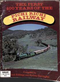
Book, Babbage, Jack, The First 100 Years of the Pichi Richi Railway, 1980
... tourist railway ill, maps, p.104. The First 100 Years of the Pichi ...A history of the first 100 years of the Pichi Richi railway from it's construction as part of the Commonwealth Railways Great Northern Railway to a preserved steam tourist railwayill, maps, p.104.non-fictionA history of the first 100 years of the Pichi Richi railway from it's construction as part of the Commonwealth Railways Great Northern Railway to a preserved steam tourist railway railroad construction - south australia - history, railway history - commonwealth railways -
 Victorian Railway History Library
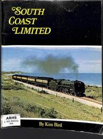
Book, Australian Railway Historical Society (S.A. Division) Inc, South Coast Limited, 1972
... to a tourist railway. ill, maps, p.81. South Coast Limited Book ...The history of the railway to Victor Harbor in South Australia from S.A.R. ownership to a tourist railway.ill, maps, p.81.non-fictionThe history of the railway to Victor Harbor in South Australia from S.A.R. ownership to a tourist railway.railroad construction - south australia - history, railroad operations - south australia - history -
 Victorian Railway History Library
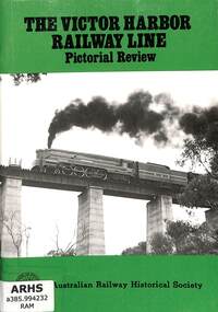
Book, Australian Railway Historical Society (S.A. Division) Inc, The Victor Harbor Railway Line Pictorial Review, 1984
... Australian Railways line to a tourist railway. ill, maps, p.52 ...A pictorial review of the railway to Victor Harbor in South Australia from an South Australian Railways line to a tourist railway.ill, maps, p.52.non-fictionA pictorial review of the railway to Victor Harbor in South Australia from an South Australian Railways line to a tourist railway.railroad construction - south australia - history, preserved locomotives - south australia - history -
 Victorian Railway History Library
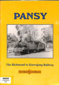
Book, The Tourist Railway Association of Kurrajong Inc, Pansy: The Richmond to Kurrajong Railway, 2000
A history of the railway from Richmond to Kurrajong on the end of the branch line from Blacktown in Sydney N.S.W.ill, maps, p.30.non-fictionA history of the railway from Richmond to Kurrajong on the end of the branch line from Blacktown in Sydney N.S.W.railroad construction - new south wales - history, railroad operations - new south wales - history -
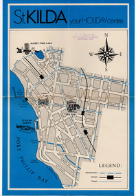 St Kilda Historical Society
Document - Map, St Kilda your holiday centre, c1970
Map of St Kilda for tourists. Undated but estimated to have been produced in 1970.Single sheet map printed on paper in blue and blackst kilda tourism -
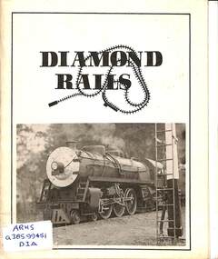 Victorian Railway History Library
Booklet, George, G.K, Diamond Rails, 1975
A brief history of the Diamond Valley Railway 71/4 inch gauge tourist railway in Eltham Lower Park.maps, p.16.non-fictionA brief history of the Diamond Valley Railway 71/4 inch gauge tourist railway in Eltham Lower Park.railroad construction - victoria - history, tourist railways and museums - victoria -
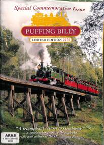 Victorian Railway History Library
Book, Emerald Tourist Railway Board, Puffing Billy: Special Commemorative Issue: A Triumphant Return to Gembrook, 1998
A brief history of the Puffing Billy railway from Upper Fern Tree Gully to Gembrook in Victoria, to commemorate the reopening of the railway from Lakeside to Gembrook in 1998.ill. maps, p.32.non-fictionA brief history of the Puffing Billy railway from Upper Fern Tree Gully to Gembrook in Victoria, to commemorate the reopening of the railway from Lakeside to Gembrook in 1998.preserved locomotives - victoria - history, puffing billy - victoria - history -
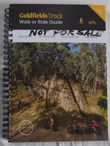 Buninyong Visitor Information Centre
Book, Gib Wettenhall, Goldfields Track: Walk or Ride Guide. 2nd Edition, 12.2017
The guide was written by Gib Wettenhall in collaboration with the Great Dividing Trail Association and Goldfields Tracks Inc. The book gives detailed information about the track including historical notes, maps and numerous photographs. Members of the Buninyong Visitor Centre and the local community actively supported the extension of the Great Dividing Trail from Ballarat through to Buninyong. Spiral bound book with photograph on cover showing mining works and tourists visiting. Title is on a black section. 'Not for Sale' handwritten in Texta on the cover.great dividing trail, goldfields, cycling, walking, tracks -
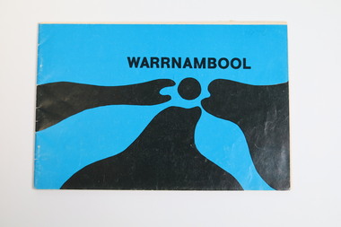
 Warrnambool and District Historical Society Inc.
Booklet - Warrnambool Visitor's Handbooks 1979-2024, Collett, Bain and Gaspar, Printers, 1979-2014
... produced between 1979 and 2014 by the City of Warrnambool Tourist ...This is a collection of eight Warrnambool Visitor handbooks produced between 1979 and 2014 by the City of Warrnambool Tourist Information Centre. They contain maps of Warrnambool, lists of services, accommodation and tourist attractions as well as many advertisements for local businesses.These handbooks give a useful snapshot of businesses and tourist attractions in Warrnambool for each of the years covered. (1979, 1980, 1986, 1990, 1993, 1994, 1995, 2014)[.1a] A 48 page booklet with white pages and blue printing. The front cover has a coloured photograph of Flagstaff Hill with boats on a man made lake in the foreground looking across Lake Pertobe toward South Warrnambool. [.1b] A coloured bifold brochure. The front cover has a fisherman on a cray-boat holding a crayfish in the lower section. The top quarter has a blue back ground with white printing. The rear cover is red and has small photos of the Hopkins River and the Framlingham Forest. [.2] A 48 page booklet with white pages and black printing. The front cover is white with black writing on the left hand side and a colour photograph of the Loch Ard peacock. The Warrnambool Premier Town stylised logo of seven Norfollk pines above blue waves is in the top right hand corner. There is a blank ink Warrnambool Library stamp underneath the logo. The rear cover has photographs of The Twelve Apostles and the Hopkins Falls and the Premier Town Logo [.3] A 40 page booklet with mainly black printing on white paper. There are three fold out maps of Warrnambool and the surrounding district. The glossy cover has a black background with a colour photograph of the Twelve Apostles taken at sunset. The rear cover has three small of Proudfoot's boathouse on the Hopkins River, Flagstaff Hill, and the main beach area. The front cover has black writing inside to peach coloured rectangles. The inside rear cover has a fold out coloured tour map of Western Victoria. [.4] A 40 page booklet printed on glossy white paper with coloured photographs and black and red printing. The front cover has a photograph of The Twelve Apostles surrounded by a white border. There is red writing in the upper border. There is a sandy coloured writing superimposed across the bottom of the photograph and a Victoria's Shipwreck Coast logo in the bottom right hand corner. [.5] A 44 page booklet printed on white paper with black printing. The cream coloured cover has a pale red rectangle with blue writing on the right hand facing edge and includes two stylised Norfolk pines and with waves underneath. There is is an intersecting blue rectangle with cream printing. [.6] A 48 page booklet printed on white paper with black printing. The cover is brown with a cream vertical strip containing black writing on the right hand side. There is a stylised map from Geelong to Mount Gambier showing the Great Ocean Road across the cover. [.7] A 48 page booklet printed on white paper with black print. The glossy colour cover has a photograph of a Southern Right whale fluke. There is white printing on a the blue background of the sky and sea. The bottom left hand side of the front cover has a Tourism Victoria logo made of jigsaw puzzle pieces. The back cover has a stylised coloured map of The Great Ocean Road located in a white rectangle at the top of the page. Within the rectangle is a small map of Australia locating Victoria and the part of Victoria covered by the map. [.8] A 64 page A5 coloured booklet printed on white pages with black print. The white front cover has black and grey print with a colour photograph of two people holding coffee cups watching four race horses being exercised on the beach and in the water of Lady Bay in the early morning. The bottom right hand corner has a Tourism Victoria logo. The rear cover has a mainly blue back ground with a pink orange and green colour splats contains words advertising the 2015 Fun 4 Kids Festival [.1a] Warrnambool The Heart of Victoria's Great Southwest Visitor's Handbook [.1b] Warrnambool City for all seasons; The Heart of Victoria's Great Southwest [.2] Warrnambool visitor's handbook Warrnambool Premier Town 1979-1982 [.3] Warrnambool Handbook Victoria [.4] Warrnambool The Shipwreck Coast [.5] Welcome to Warrnambool Warrnambool Visitors Handbook 1993-1994 [.6] Welcome to Warrnambool Visitors Handbook 1994-95 Rear cover: Warrnambool Centre of Victoria's Shipwreck Coast on Australia's Great Ocean Road [.7] Warrnambool Shipwreck Coast - Great Ocean Road; You'll love every piece of Victoria; Visitors Handbook [.8] Warrnambool Great Ocean Road Official Visitor Guide; It's a wonderful Warrnambool; You'll love every piece of Victoria visitvictoria.com. Rear Cover Live entertainment.Workshops.Creativity.Action 28 June - 5 July 2015 Australia's Best Children's Festival F4K The ultimate winter school holiday adventure Fun 4 kids festival Warrnambool For more information visit Fun4kids.com.au Warrnambool great Ocean Road Victoriawarrnambool, visitor handbooks, tourist information guides, warrnambool maps -
 Warrnambool and District Historical Society Inc.
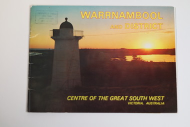
Booklet - Tourist Booklet, Warrnambool Chamber of Commerce and Industry, Warrnambool and District - Centre of the Great South West, Victoria, Australia, c. 1970
Warrnambool Tourist BookletThis is a booklet of 22 pages. The cover has two colour photographs and the pages contain a sketch map, printed text and colour photographs. The pages have ben stapled but the staples have been removed.non-fictionWarrnambool Tourist Bookletwarrnambool tourism, south west victoria tourist locations, warrnambool chamber of commerce -
 Warrnambool and District Historical Society Inc.
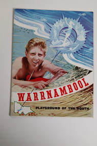
Document - Warrnambool Playground of the South Tourist Guide, Collett & Bain, 1959
A 1959 tourist guide showcasing Warrnambool attractions.This guide gives an insight into tourist attractions and facilities in Warrnambool in the late 1950'sThis 24page paper booklet contains colour and black and white photographs and text showcasing Warrnambool as a tourist destination. The front cover has an illustration of a young man on the sand dunes, a small map of Victoria locating Warrnambool in the bottom left hand corner and stylised tourist activities in the top right hand quadrant. The rear cover has a photograph of a woman in a swimsuit holding a green surf board surrounded by stylised tourist activities printed in red ink. There is a blue banner across the bottom of the rear cover.Front cover: Warrnambool Playground of the South Rear cover: A Warrnambool Holiday for Everyonewarrnambool, warrnambool tourist guide -
 Federation University Historical Collection
Map - Ephemera, Melbourne City Tourist Shuttle, c2006
... . Melbourne City Tourist Shuttle Map Ephemera ...John So was Mayor of Melbourne from 2001-2008A brochure with a map of the Melbourne Central Business District.melbourne, southbank, melbourne docks, fitzroy, carlton, east melbourne, john so -
 Melbourne Tram Museum
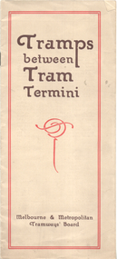
Booklet, Melbourne & Metropolitan Tramways Board (MMTB), "Tramps between tram termini", c1930
Booklet - promoting tram travel and walking trips or "tramps" between various tram terminus. Includes notes on the Board's services, its tourist tram with notes and fares on specific walks. Includes a map and some photos for each walk. 1 - Brighton Road to Hawthorn 2 - Burwood to Mont Albert 3 - Carnegie to Darling Road 4 - Whitehorse Road to East Kew 5 - Glen Iris to Darling Road 6 - Maribyrnong River to Mt Alexander Road 7 - Gardiner or Glen Iris to Burwood 8 - Wallen Road Bridge to Glenferrie Road 9 - Johnston St Bridge to Victoria Bridge At the time, some of these walks would have been through largely undeveloped land and parks.Demonstrates a promotion of the MMTB tram services and leisure activities.Booklet - 16 pages, two colours on light fawn paper, centre stapled.tramways, showgrounds, william st, mmtb -
 Bendigo Historical Society Inc.
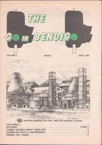
Magazine - THE GO IN BENDIGO - MAGAZINE, April 1986
Magazine - 16 page guide for visitors and residents of Bendigo. Vol.2, Issue 4, April 1986. Includes tourist attractions, wineries, dining out, with a map on the back page. Sketch of the Bendigo Pottery by Stan Thomas on front cover. Editor Barry McNaught. Publisher not mentioned. bendigo attractions, bendigo pottery, stan thomas, barry mcnaught, rosalind park, gail tavener, arakoon resort -
 Hymettus Cottage & Garden Ballarat
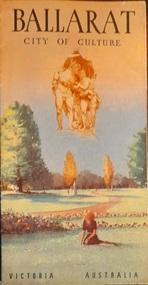
Work on paper - Tourist Brochure, Ballarat, City of Culture
Single sheet folding inwards with photographic illustrations and accompanying text and district map. Measurements vary as listed folded and unfolded.ballarat, culture -
 Falls Creek Historical Society
Document - Information Bulletin April 1961
Bob Hymans Collection Bob (Herman) Hymans (a former member of the Royal Netherlands Navy) was born in Bloemendaal, Holland on 30th September 1922. During World War II he fought against the Japanese in the Dutch East Indies (now Indonesia) and was imprisoned in Changi and on the Burma Railway. After gaining qualifications as a Ski Instructor, Bob arrived in Falls Creek in July 1950. Working as an Instructor and Supervisor at Bogong Lodge, Bob decided his future was in accommodation. He was successful in negotiating an indenture for land from the State Electricity Commission (SEC). It took Bob two years to build his Grand Coeur Chalet but, tragically, it was burned down in August 1961. Bob also built the first Chairlift in Australia. This was a single chairlift and the structure was built from wooden electricity poles. He was constantly full of new ideas and proposals for the village. Bob Hymans died on 7th July 2007. This Collection of documents and letters tells the story of Bob's endeavours to develop Falls Creek into the ski village it is today.This letter is significant because it documents developments made or endorsed by the Falls Creek Tourist Area Management Committee.An information bulletin published by the Management Committee. Information included is the release of a new subdivision map, establishment of a Ski Rescue Service and notification that Bob Hymans' would not be in operation for the coming season,falls creek tourist area management committee, preparations for winter season 1961 -
 Stawell Historical Society Inc
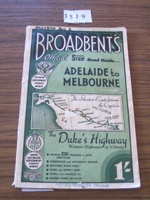
Book, Broadbent directory, Broadbent's Official : Speedo Strip Road Guide, 1943
Maps and descriptions of towns on the Western Highway & Dukes Highway from Melbourne to Adelaide. Sponsored by R.A.C.V and The Victorian Government Tourist BureauCream paper cover back border with green filling with a map from Melbourne to AdelaideBroadbeants Official Speedo Strip guide Melbourne to Adelaidestawell transport -
 Mont De Lancey
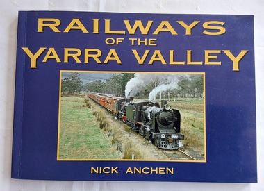
Book, Nick Anchen, Railways of the Yarra Valley, 2010
The railway reached Lilydale in 1882, Healesville in 1889 and Warburton in 1901 linking the area to Melbourne. Sawmillers and farmers prospered, as well as tourists visiting the region.A blue covered book of the Railways of the Yarra Valley with a photograph on the front cover of the last steam train from Warburton in August 1965 and the back cover showing an old locomotive 'Little Yarra' in 1913. There is historical text and maps with black and white and coloured photographs of the railways and of the area.Pp.96.non-fictionThe railway reached Lilydale in 1882, Healesville in 1889 and Warburton in 1901 linking the area to Melbourne. Sawmillers and farmers prospered, as well as tourists visiting the region. trains, rail vehicles, australian history, yarra valley -
 Warrnambool and District Historical Society Inc.
Booklet - Booklet Collection: City of Warrnambool Tourist Guides, Collett, Bain and Gaspar, Warrnambool
This is a collection of sixteen tourist guides dating from the mid 1970's to 2013. These contain listings of businesses, accommodation, eateries and events in Warrnambool and district. They also include maps of Warrnambool and surrounds, advertising and photographs of various attractions. While mainly covering Warrnambool a small number of the guides cover the South West Region. These directories have mainly been published by the Warrnambool City Council and are a selection of the types of information provided to visitors at the Tourist information centre during this time period.These tourist guides give snapshots of the City of Warrnambool for the years covered and will be useful for research.[.1] An 8 page paper booklet with black printing and a black & white photo of the pond at the Botanical Gardens on the front cover. [.2] two photocopied A4 black and white pages from the book "On the Trail" K Winser 1956 (Main Roads of Australia) [.3] A trifold colour brochure with a stylised map of the coast on the yellow and blue front cover. The inside has stylised colour drawings on Warrnambool attractions. The rear cover has coloured photographs of bush, Liebig Street and Fletcher Jones gardens [.4] A trifold black and white brochure with a black line drawing of a whale on the front cover. [.5] A trifold white card with mauve printing. The front cover has a line drawing of the former Timor Street post office and a map of businesses and landmarks in Timor Street. The reverse side contains a brief history of Warrnambool. [.6] A 98 page stapled booklet with a foreword by Vanda Savill. There are 4 pages of coloured photographs. The remainder are black and white photographs. The front cover is purple with white writing in the lower third. There is an outline of the coast and five colour photographs of district attractions. The inside middle page has a map of the Western wonderland region. The content covers towns in this area. Content relating to Warrnambool is in the last six pages. [.7] Twelve loose photocopied black and white pages. The front cover has the Warrnambool Premier Town 1988-1991 logo and a photo of a Southern Right Whale and calf. The bottom right hand corner has a Standard Warrnambool logo. [.8] 44 page booklet printed with blue ink. The staples have been removed. The glossy front cover has blue printing with a coloured photo of Flagstaff Hill Maritime Village pond. The centre pages has a fold out map of the City of Warrnambool. The rear cover has photos of The Twelve Apostles and Hopkins Falls. [.9] 4 loose photocopied pages with Warrnambool Library and Corangamite Regional Library Service Warrnambool City Library black ink stamps. The front page line drawing illustrations of Warrnambool attractions [.10] A single sheet of glossy white paper folded in half to make four pages. The front page has a Warrnambool premier town logo 1979-1982 and blue printing and a visitor survey. [.11] A conference pack of light card folded to make a pocket containing three brochures, a shipwreck coast tourist directory and a Australian Heritage Parks Association conference program dated 24 to 27 May 1992. The front cover of the pack has green writing over a stylised upward arrow. There is a City of Warrnambool logo in the top right hand corner and two film strips diagonally across the cover containing photographs of Warrnambool. The rear cover has a coloured Warrnambool Premier Town logo. [.12] A 63 page stapled booklet with coloured photographs of Warrnambool. The front cover has black writing on white background. There is a coloured photograph of Flagstaff Hill in the middle of the cover and a Warrnambool City and Visit Victoria logos on the lower edge. The middle pages has a coloured of the city of Warrnambool with an inset map of Allansford. [.13] A single large sheet of white paper folded in ten to make a brochure. The front cover has black printing. The rear cover has a purple ink stamp for the City of Warrnambool Tourist Information Centre. When folded out the reverse side has a green, grey and white map of the South West Region of Victoria. [.14] A 48 page colour booklet on glossy paper. The front cover has white writing on a blue background and includes photographs of the Twelve Apostles, the Promenade walk, Flagstaff Hill and a southern right whale's tail. The rear cover has photographs of The Twelve apostles, a passenger train from Melbourne passing the Lake Pertobe playground, and a rural scene. There is white writing and a white Warrnambool City logo on a blue background. The centre pages have a stylised green and blue map of the city of Warrnambool. [.15] A 48 page colour booklet on glossy paper. The front cover has white writing over colour photographs of two people at a lookout, Flagstaff Hill, three southern right whales and a child at the Lake Pertobe playground. The lower edge has blue upper case writing on a white background. The rear cover has a colour photograph of the Twelve Apostles. The lower white border on the rear covers has a a blue and green City of Warrnambool logo and blue writing. The centre pages have a stylised green and blue map of the city of Warrnambool. [.16] A 64 page colour booklet on glossy paper. The front cover has black writing on a black background and there is a photograph of a southern right whale's tail. The lower edge has the Warrnambool City and Visit Victoria Logos. The centre pages have maps of Warrnambool and surrounds. [.1] This week in Warrnambool Vol 2 No. 5 Thurs 1st Feb. For the time of your life [.2] Warrnambool Way [.3] Warrnambool The Holiday Host on the South West Coast with compliments City of Warrnambool and Warrnambool Chamber of Commerce [.4] MMI Insurance presents Whales Giants of the Deep Whale Watcher's Logbook Warrnambool [.5] Warrnambool History began in Timor Street [.6] Western Wonderland Tourist Association [.7] A Premier Arrow Tour of Warrnambool Victoria's Premier Town Australia's Southern Right Whale Nursery [.8] Warrnambool The Heart of Victoria's Great Southwest Visitor's Handbook [.9] What to see in Warrnambool Victoria's Premier City 1979-1982 [.10] Win a Free Holiday & $200 Cash in Victoria's Premier Town [.11] Advancing Warrnambool together! [.12] Great Ocean Road Warrnambool Official Visitor Guide [.13] Tourist guide to the South West Region Victoria All it needs is you [.14] Warrnambool visitor guide 2005 the great ocean road experience attractions accommodation entertainment dining [.15] Warrnambool Visitor Guide 2006 the great ocean road experience Attractions Accommodation Entertainment Dining [.16] Official Visitors' Guide Warrnambool Victoria Australia Discover the Great Ocean Road warrnambool, warrnambool tourist guides -
 Victorian Railway History Library
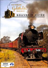
Naylor, Andrew, Victorian Goldfields Railway Souvenir Guide, 2017
A souvenir guide book for the Victorian Goldfields Railway from Castlemaine to Maldon in Victoria.ill, maps, p.47.non-fictionA souvenir guide book for the Victorian Goldfields Railway from Castlemaine to Maldon in Victoria.preserved locomotives - victoria - history, tourist railways and museums - victoria -
 Warrnambool and District Historical Society Inc.
Booklet - Tourist booklet, Warrnambool Chamber of Commerce and Industry, Warrnambool, c. 1970
Warrnambool Tourist BookletThis is a booklet of 30 pages with a blue and black cover featuring an art work, a map, advertisements, black and white photographs and printed text. The booklet was stapled but the staples have been removed.non-fictionWarrnambool Tourist Bookletwarrnambool tourism, warrnambool tourist guides, warrnambool chamber of commerc -
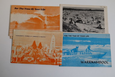 Warrnambool and District Historical Society Inc.
Booklet - Warrnambool Tourist Guides (5), Warrnambool Chamber of Commerce and Industry, Warrnambool - For the Time of Your Life, 1970-1975
Warrnambool Tourist Guides 1970-1975.1,.2,.3 - These are booklets of 36 pages with an orange cover with an illustration of two people on surf boards on the front cover and an image of a main street on the back cover. The cover has blue printing. The pages contain a map, advertisements, black and white photographs and printed text. One booklet is stapled and two have the staples removed. .4,.5 -These are booklets of 40 pages with a front cover with a photograph in blue tones of a surf patrol boat and two lifesavers and a back cover with a black and white photograph (beach scene). The pages contain a map, advertisements, black and white photographs and printed text. One booklet is stapled and one has the staples removed. non-fictionWarrnambool Tourist Guides 1970-1975warrnambool tourism, tourism in warrnambool in the 1970s -
 Warrnambool and District Historical Society Inc.
Pamphlet (Collection) - Warrnambool Tourist Maps, Warrnambool City Council, 1975 to 2002
... the time frame 1975-2002. Warrnambool Tourist Maps Pamphlet ...Warrnambool Tourist Maps collected over the years by Warrnambool Historical Society membersPreservation of local maps for historical purposesEnclosed in A4 size plastic envelopes in an A4 size archival box and numbered and catalogued according to the date of acquisition.This collection has 16 pamphlets containing maps of Warrnambool and district and some accompanying printed materialwarrnambool tourism, city of warrnambool, shipwreck coast tourismwarrnambool tourism, city of warrnambool, shipwreck coast tourism -
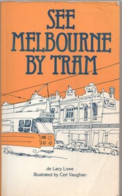 Melbourne Tram Museum
Book, Lacy Lowe, Ceri Vaughan, "See Melbourne by Tram", 1982
Book - 160 pages + card cover with maps on inside covers, titled "See Melbourne by Tram" written by de Lacy Lowe, illustrated by Ceri Vaughan, published 1982. Gives a description of 22 Melbourne tram routes with a stop description (not all stops covered) and sketches associated with the location. Has an index in the rear pages.trams, tramways, melbourne, tram routes, tram stops, tourist guides, illustrations -
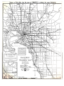 Melbourne Tram Museum
Map, Gawler and Drummond Architects, "Railway and Tramway Map of Melbourne and Suburbs", 1920's?
Map - photocopy - titled "Railway and Tramway Map of Melbourne and Suburbs", c1920 showing railways, cable, electric tramways and authorised electric additions. Shows the South Melbourne St Kilda tram line and some lines in the Footscray area as dotted. Prepared by Gawler and Drummond Architects. Has an advertisement for "Rolfes" tea along the top edge and "See Victoria First" - Government Tourist Office, corner of Swanston and Collins St.trams, tramways, map, footscray, st kilda, new tramway, melbourne, tourism -
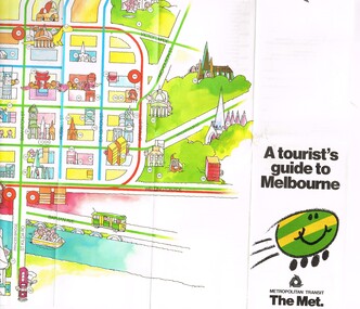 Melbourne Tram Museum
Pamphlet, The Met, "A tourist's guide to Melbourne", mid 1980's
Pamphlet, 14 fold printed in full colour on semi gloss paper, both sides. Gives a cartoon style map of the CBD, Melbourne suburbs and outer Melbourne, giving a list of places of interest and transport routes. Shows the vintage tram service along Batman Ave, Puffing Billy, Wattle Park, various precincts, shopping centres. Published by The Met, Metropolitan Transit and has the buzz logo on the front. Mid 1980's. Two copies heldtrams, tramways, maps, tourism, melbourne, wattle park, the met