Showing 2474 items
matching townships
-
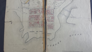
 Port Melbourne Historical & Preservation Society
Plan, The Township of Sandridge, 30 Mar 1859
Plan of the township of Sandridge.Lithographed at the Public Lands Office, Melbourne, March 30th 1859engineering - roads streets lanes and footpaths, municipal district of sandridge -
 Buninyong & District Historical Society
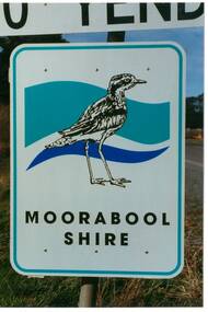
Photograph - Original Photograph, Mr. C.J. Brooks, Moorabool Shire sign closeup, September 1995
Social, historicalExample of the Moorabool Shire sign in the late twentieth centuryColour photo, closeup of the Moorabool Shire sign on the Western outskirts of the township of Yendonroad signs, yendon, moorabool shire, streetscape -
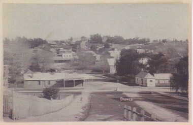 Clunes Museum
Photograph, UNKNOWN
BLACK AND WHITE PHOTOGRAPH OF CLUNES TOWNSHIP. TAKEN FROM CAMERON STREET HILL.local history, photography, photographs, clunes township -
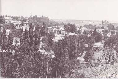 Clunes Museum
Photograph
COPY OF BLACK AND WHITE PHOTOGRAPH OF CLUNES TOWNSHIP, TAKEN FROM LUGG STREET.local history, photography, photographs, clunes township -
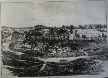 Clunes Museum
Photograph, CIRCA 1880
AN ETCHING OF VERY EARLY CLUNES. TREE GUARDS AROUND TREES ALONG CREEK BANK, ORIGINAL NAMED TULLAROOP CREEK.CLUNES TOWNSHIP, CRESWICK CREEK, DOUBLE STORY BUILDINGS AND MINE POPPET HEADS.TOWN OF CLUNESlocal history, photography, photographs, clunes township. -
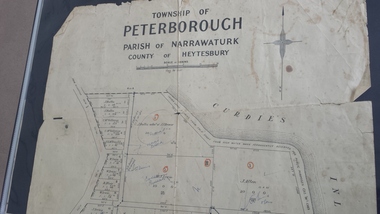 Peterborough History Group
Map - Map of the township of Peterborough, Township of Peterborough
Same map as 4012 but printed names are easier to read. Hand drawn arrows show the road now built connecting Macs St to the Warrnambool RdShows early layout of the town and names of landownersgovernment map of the township of Peterborough with handwritten notes on it. Includes the names of the landowners 1931some hand drawn arrows.peterborough, old maps, maps -
Stawell Historical Society Inc
Map, Township of Stawell Photo Map, 1947
Photograph of Stawell from Air Circa 1947. Shows mining sites and townshipmining, gold, map -
Whitehorse Historical Society Inc.
Document, Division of Survey and Mapping, 1984
Information guide to Parish and Township Plans - Division of Survey and Mapping - Victorian Government..Information guide to Parish and Township Plans - Division of Survey and Mapping - Victorian Government..Information guide to Parish and Township Plans - Division of Survey and Mapping - Victorian Government..crown lands, victorian government, land surveys -
Whitehorse Historical Society Inc.
Document, Blackburn Township Estate, 1910
Auction of 124 lots of the Blackburn Township Estate on Saturday 19th November 1910,Auction of 124 lots of the Blackburn Township Estate on Saturday 19th November 1910,Auction of 124 lots of the Blackburn Township Estate on Saturday 19th November 1910,blackburn township estate, 124 lots -
Whitehorse Historical Society Inc.
Document, Virtual Vermont - Norwich Township, 2015
A draft copy of a book on the history of the failed Norwich Township proposal in Vermont 1858.A draft copy of a book on the history of the failed Norwich Township proposal in Vermont 1858.A draft copy of a book on the history of the failed Norwich Township proposal in Vermont 1858.norwich village vermont, proposed -
 Whitehorse Historical Society Inc.
Article, Blackburn A Model Township, 1880's
During the boom years of the 1880's, the new township of Blackburn was designed and built.During the boom years of the 1880's, the new township of Blackburn was designed and built.During the boom years of the 1880's, the new township of Blackburn was designed and built.blackburn, gardiner's creek, blackburn lake, freehold investment and banking company of australia ltd, goodwin, george augustus -
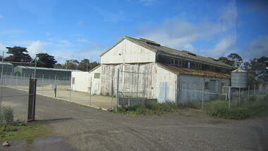 Ballarat Heritage Services
Photograph - digital images, L.J. Gervasoni, Cocoroc township - Werribee farm, 2011
Colour digital images images showing the former township of Cocoroc, Werribee farmcocoroc, town, shed, werribee farm, mmbw, melbourne metropolitan board of works, settlement, farm -
 Stawell Historical Society Inc
Photograph, Open Cut Big Hill overlooking Stawell towards Grampians
Scotts Open Cut Big Hill c 1960 overlooking Stawell towards Grampians. The first quartz was mined for in the open cut from Fisher Street, to the Big Hill, below the Pioneers Memorial.Black and white photograph of an open cut on the side of a big hill. The township in the background.stawell mining -
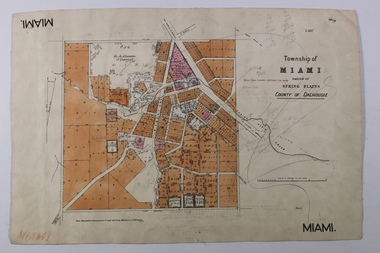 Bendigo Historical Society Inc.
Map - MIAMI ( MIA MIA), 26/06/1906
The name Miami on the is a misprint Map: Township of Miami (Mia Mia), Parish of Spring Plains, County of Dalhousiemap, dalhousie, township, mia mia, spring plains creek -
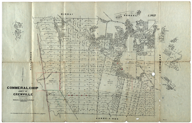 Federation University Historical Collection
Plan, Commeralghip, County of Grenville, 1905, 03/02/1905
The Township of Kaleno is in the Pitfield Plains. The Cape Clear Cemetery T contains the graves of miners and local pioneering families from the Cape Clear, Hollybush, Kaleno, Pitfield Plains, Pitfield, Illabarook, Berringa, Springdallah, Wallinduc, Glenfine, Happy Valley and Western Creek districts.Plan of allotments in Commeralghip, County of Grenville, Victoria. The plan includes the township of Kaleno, Dereel Pre-Emptice Right (John Cullen), Commeralghip Pre-Emptive Right (John Gordon McMillan and Glenfine Pre-Emptive Right (William Rowe). It also includes landholders such as Robert mcPherson, C. Cameron. John Boyd, John Cullen, W.T. Rowe, George Currie, J.P. Mackay, T. McCaffery, G. Hawkins, Alexander McPherson, C. Cameron. Gift of the Squire Family, 2014commeralghip, pitfield plains, kaleno, dereel, glenfine, squire, richard squire, w.t. rowe, john cullen, alexander mcpherson, george currie, mt misery, william rowe, mindai, john gordon mcmillan -
Clunes Museum
Photograph, CLUNES IN THE 1860'S
CRITERION. QUARTZ MINING COMPANY REGISTERED CLUNES VIEW IN TOWNSHIP, CLUNES, SOUTH EAST CAMP PARDE, CLUNES, SOUTH WEST PORT PHILLIP AND COLONIAL GOLD MINING COMPANY, CLUNES VICTORIAN QUARTZ MINING COMPANY, REGISTERED CLUNESCLUNES IN THE 1860S FIVE VIEWS BY CHARLES NETTLETON .1 LARGE ENVELOPE WITH DESCRIPTIONS OF EACH OF THE PHOTOS. PUBLISHED BY SHIRE OF TALBOT AND CLUNES FROM ORIGINAL PHOTOGRAPHS. .2 PHOTO PRINT - VIEW IN TOWNSHIP, CLUNES, SOUTH EAST .3 PHOTO PRINT - CAMP PARADE, CLUNES, SOUTH WEST .4 PHOTO PRINT - PORT PHILLIP AND COLONIAL GOLD MINING COMPANY, CLUNES .5 PHOTO PRINT - VICTORIA QUARTZ MINING COMPANY, REGISTERED, CLUNES .6 PHOTO PRINT - CRITERION QUARTZ MINING COMPANY, REGISTERED. CLUNESC. NETTLEFOLD, PHOTO, MELBOURNElocal history, photography, photographs, mining, clunes in the 1860's five views by charles nettlefold -
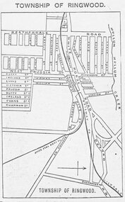 Ringwood and District Historical Society
Photograph, Directory of Ringwood Township, from Sands and McDougall Directory - 1905. (New Street is incorrectly shown as Heatherdale Road on this map. Heatherdale Road's actual location is to the east, beyond the top of the map perimeter.)
Catalogue card reads, 'Directory of Ringwood Township - 1905. From Sands and McDougall Directory.' -
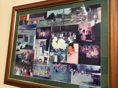 Pyrenees Shire Council
Photographs, Lexton 150th Celebrations (1 of 2), c1995
significant to the Pyrenees Shire and Lexton communityframed photo montage"Inscribed front: 150th Birthday Celebration Lexton Township 4-5 Nov 95" -
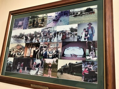 Pyrenees Shire Council
Photographs, Lexton 150th Celebrations (2 of 2), c1995
significant to the Pyrenees Shire and Lexton community"Inscribed front: 150th Birthday Celebration Lexton Township 4-5 Nov 95" -
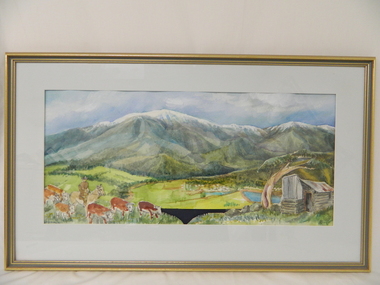 Kiewa Valley Historical Society
Painting, Cattlemen of the Bogong High Plains, c1995
Leo Wimmer who lived locally was commissioned to do the painting for the Mt Beauty, S. K. Pearce Pty. Ltd., Supermarket as a display was wanted to fit against the blank walls opposite the cash registers (where the liquor store is now). His idea was to break up the parts in the painting and use these as large replicas painted on wood for the display. An official opening was held and Leo used the money earned to visit his homeland, Austria. Leo trained as a restorer of church art in Austria.This painting was commissioned for a Cattlemen's display behind the cash registers at the Mt Beauty S. K. Pearce Supermarket. Each part of the foreground was painted separately onto stand alone boards -the cattle, the hut, the grass and the Mt Beauty township. Leo Wimmer lived locally and was a professional frame conservator. Leo Wimmer specialised in gilding and worked at the National Gallery of Victoria and later the National Gallery of Australia (NGA Nov. 1981 - 1990) where he was responsible for conservation of gilded frames in the national collection. This involved crafting of missing pieces on period frames, conservation/restoration of gilded surfaces, crafting of period frames, and lecturing at galleries and institutions on gilding, wood carving, Australian frame history and crafting of period frames. Framed painting of Mt Bogong with cattle, Mt Beauty township and cattleman's hut in foreground.Circular watermark (illegible) on bottom right corner. "Wimmer / 1" is underneath the watermark.cattlemen; bogong high plains; s.k.pearce; mt beauty supermarket; leo wimmer; -
Ringwood and District Historical Society
Literary work - Envelope, Packet: Percydale - small mining township - history written by Betty Austin of Ringwood (June 1966)
Percydale - small mining township - history written by Betty Austin, Kendall Street Ringwood -
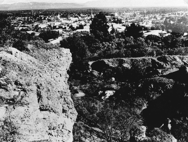
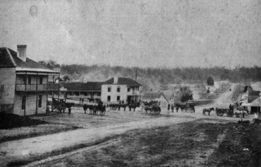 Federation University Historical Collection
Photograph - Image, Buninyong, 1859 - Looking North, 1859
Buninyong was Victoria's first inland town, and is in close proximity to Ballarat. The fledgling township of Buninyong. Early buildings line the streets, and horse drawn carriages are evident. buninyong -
Port Melbourne Historical & Preservation Society
Document, "The Township of Sandridge 1860 Names of Lot Owners", 1990s
Six foolscap pages listing the names of the lot owners in 1860 in the township of Sandridge: Handwrittenbuilt environment -
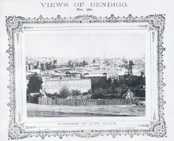 Bendigo Historical Society Inc.
Photograph - VIEWS OF BENDIGO: TOWNSHIP OF LONG GULLY, c. 1870's
Photograph No. 28: Sepia photograph of Township of Long Gully. (Two Copies) Nicholas CairN J Caireplace, landscape view, golden square -
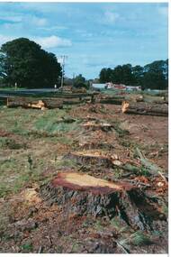 Buninyong & District Historical Society
Photograph - Original Photograph, Mr. C.J. Brooks, Main street of Yendon from the West showing felled pine trees and tree stumps, September 1995
Social, historicalExample of the felling of trees for power company in the late twentieth centuryColour photo, of the Western outskirts of the township of Yendon showing felled pine trees and stumps yendon, moorabool shire, streetscape, felled pinetrees, powercor -
Tatura Irrigation & Wartime Camps Museum
Folio, Murchison Memoirs. A Trevaskis, May, 1990
Family History of A. Trevaskis32 pages of recollections by A. Trevaskis of his Family and Murchison families and Township 187 - 01990My Memories of Murchison by Arthur Trevaskisdocuments, biography -
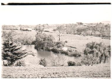 Hume City Civic Collection
Photograph
A b/w photograph of a landscape view showing Jackson's Creek with the Sunbury township in the background.Handwritten on back: McMahonmcmahon, landscapes, jackson's creek, sunbury, george evans collection -
Clunes Museum
Document - POSTCARD AND REPORT, UNKNOWN
POSTCARD OVERVIEW OF CLUNES TOWNSHIP, TOGETHER WITH A BRIEF REPORT REGARDING THE CLUNES POST OFFICElocal history, documents, reports, postcards, clunes post office, clunes township -
 Peterborough History Group
Map - Map of the town, Government Printer, Township of Peterborough
Map donated by Barry Jenkins and assume that updated names were written on the map by him. Good information pertaining to the history of each allotment. Significant as it shows the names of the owners of each allotment in 1931 and handwritten notes of more recent owners.27/6/1931 paper map of the township of Peterborough including names of the landowners at that time.Handwritten landowner names over the original printed names.peterborough, old maps, maps -
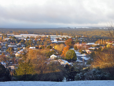 Ballarat Heritage Services
Photograph - Digital photographs, L.J. Gervasoni, View of Daylesford in Snow from Wombat Hill Botanic Gardens, c2012-2016
Daylesford is a Central Victorian town. Colour photograph from the Wombat Botanical Gardens showing snow covering the township of Dayelsford. daylesford, snow, weather, climate, winter, daylesford botanic gardens, botanic gardens, wombat hill, wombat hill botanic gardens, cityscape, viewscape