Showing 3883 items
matching tracks
-
 Stawell Historical Society Inc
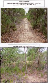
Photograph, A Track into Grampians Quarry -- Previously a Railway Line & Rifle Range Taken 2017 -- 2 Photos -- Coloured
Two colour photographs of Track into Quarry Road Grampians. Once Rail Line used in construction of dam wall, later used as rifle range. The rifle range was once the last part of the railway track that ran to the quarry which was used to cart stone to Lake Fyans when it was being constructed. (1912-1918). The rifle butts are near to or part of the quarry. The Rifle range can still be seen. Two colour photographs of bush setting with track and dirt mound (rifle butts)stawell -
 Phillip Island and District Historical Society Inc.
Photograph, circa 1900
Foreground track leading down to two jetties and shed of San Remo Harbour. Near shed a covered wagon. Coal boat at end of jetty. Large shrubbery on left of picture. Phillip Island foreshore across Westernport in background.Track leading to passenger and coal jetties, Phillip IslandPhillip Island from San Remo Harbourlocal history, photography, photographs, slides, film, san remo harbour, jetties, black & white photograph, miss elms san remo -
 Melbourne Tram Museum
Photograph - Commissioning Queensway tram line, Warren Doubleday, 18-10-1968
Photos show the commissioning or testing of the tram track between Chapel St and St Kilda Junction by W7 940 on 18-10-1968. The first tram travelled on the outbound or down line, rather than the inbound or up line. 1 - At Chapel St 2 - climbing up to St Kilda Junction 3 - At St Kilda Junction with the track on the left side of the photograph being the track in use at the time to bypass the new work.Yields information the commissioning of new track at St Kilda Junction.Set of three Black and white photographs of the commissioning of tram tracks between Chapel St and St Kilda Junction.Has details on rear in blue ink.tramways, trams, tram 940, new tramway, track work, st kilda junction, chapel st, commissioning -
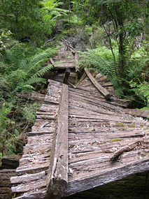
 Marysville & District Historical Society
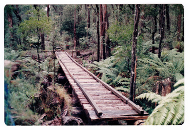
Photograph (item) - Colour photograph, Doug Orford, Unknown
A colour photograph of the timber tramway bridge along the Michaeldene Walking Track near Marysville in Victoria.A colour photograph of the timber tramway bridge along the Michaeldene Walking Track near Marysville in Victoria. The Michaeldene Trail to Taggerty River Lookout is a 4.3 kilometer lightly trafficked loop trail located near Marysville, Victoria. The track is one of several walking tracks located in and around Marysville in Victoria.Doug ORFORDtimber tramway, michaeldene walking track, marysville, victoria, walking track -
Marysville & District Historical Society
Document (Item) - Document-Table, Judith Vimpani, Yarra Track Hostelries- Marysville to Woods Point, Unknown
A document outlining all the hostelries that existed along the Yarra Track between Marysville and Wood's Point.A document outling all the hostelries that existed along the Yarra Track between Marysville and Wood's Point.yarra track, marysville, wood's point, woods point, fernshaw, paradise plains, black spur, mount grant, george edwards, walker family, melbourne, new chum, hit & miss restaurant, mr clifford, michael woods, glen watts, tri bhean hotel, ewen cameron, ewen hugh cameron, thomas barton, butler's wood's point directory, globe hotel, swanston street, mount juliet, ben more & c, jordan district, jefferson's watts bridge inn, matthew jefferson, reefer's hotel, boyle's hotel, william henry johnson, samuel boyle, black spur hotel, fisher's creek, narbethong, fisher's home hotel, black spur inn, frederick fisher, william hodson, wood's point road, acheron river, acheron bridge hotel, john robson, granton, clifford, wilks creek, wilks creek hotel, patrick maloney, steavenson, marysville hotel, australian hotel, junction hotel, the dutchman's restaurant, henry kuyper, william podlech, mount arnold, mount arnold hotel, charles schultz, james toohey, john gleeson, joy burchall, ian newman, henry brockman, belle isle, belle elle, bellell creek, upper yarra, guerin's bridge, bell's hotel, henry petty, celia moran, ruth petty, cumberland creek, cumberland creek store and restaurant, cumberland creek hotel, charles edwin hargreaves, annie hargreaves, urina hargreaves, alice hargreaves, healesville, josiah hargreaves, henderson drysdale, henry whelan, halfway house, thomas smith, svendson, gosling, donovans creek, chesterville, perry's hotel, john perry, perry's coach and horses hotel, edward courtney, scandinavian hotel, the swede's, walker's hotel, jacob burchart, golden fleece, theodore kappler, george koehler's hotel, david walker, millicent walker, elsie jowett, bill walker, big river, royal mail hotel, shaw's, slingsby davies, edwin jones, elizabeth jane parker, sandridge, archibald charles edwin jones, matlock, alexander myers, frank berwick frederick jones, ned jones, jennie jones, sophie milllicent parker jones, thomas shaw, dorothy walker, travellers rest hotel, reefton, summers, john fehring, f fehring, katerina fehring, john christoph blumeyer, anne fehring, john baker, evelyn observer, anna katrina baker, hannah catherine baker, john frederick baker, mcmahon's creek, oaks, the springs, st clair, sinclair's valley, mountain home hotel, neilson, collins, waters, jan emma sinclair, john sinclair, mr cox, peter sinclair, willie we have missed you hotel, spring vale hotel, robert matthews, thomas crawford -
 Ballarat Tramway Museum
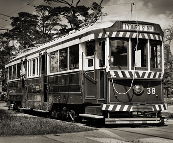
Photograph - Ballarat 38 - BTM, Greg Naylor, 2022
Black and White photo of Ballarat 38 - BTM on depot access track. See reference for the history of this tram. Photographed during 2022 on a Mamiya RB67 large format film camera.Yields information about BTM tram 38.Black and White photo of Ballarat 38 - BTM on depot access track.btm, trams, tramcars, tram 38 -
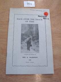 Stawell Historical Society Inc
Book, N.A. McLennan, Back over the track of Time by N A McLennan, 1970
A History of BanyeaGrey Card Cover with border insode of which is text and B/W Photo of a man walking along a track carrying a swag In Blue Ink Underlined: Banyana History Inside Border Back over the Track of Time Compiled and written by Neil A. McLennan 1970 Stawell Victoriastawell, mclennan family -
Whitehorse Historical Society Inc.
Document, Dorothy Maxwell, 9/05/2005 12:00:00 AM
Interview of Dorothy Maxwell by Valda Arrowsmith.Interview of Dorothy Maxwell by Valda Arrowsmith, about the establishment of the Bill Sewart Athletics Track and the Little Athletics movement.Interview of Dorothy Maxwell by Valda Arrowsmith.bill sewart athletic track, nunawading little athletics club -
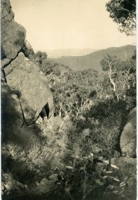 Stawell Historical Society Inc
Postcard, Track to Mackey's Peak Showing Lake Fyans in Distance in the Grampians -- Postcard
Photographic post card of track to Mackey's Peak showing Lake Fyans in distance "The Grampians".Black and white photograph of a bush scene with mountain views.Post Card Kodak Australia written in pencil on the back "The Track to Mackey's peak showing Lake Fyan's in distance".halls gap grampians -
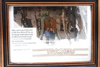 Falls Creek Historical Society
Photograph - "Baldy" Blackwell and Trackers
This photo is from the private collection of George Shirling of Red Onion, Falls Creek. George Shirling arrived in Falls Creek in 1962. He engaged Phil Nowell to build the original Koki Alpine Lodge which opened in 1965 with 14 beds. George operated the lodge with Michael “Baldy” Blackwell as manager. He also graduated in sport psychology in 1981 and was invited to become team psychologist for the Australian Winter Olympic team which went to Albertville, France, in 1992. He later owned the Red Onion Chalet. George credited the success of Koki to “Baldy” Blackwell. “Baldy” and Phil Nowell started the Trackers Mountain Lodge in partnership during the 1980s. In 1971 George sold Koki Lodge to Sigi Doerr. In 2024 the renamed Koki Alpine resort remains a highly popular destination in Falls Creek. George Shirling passed away on 27th February 2023. He had remained actively involved in Falls Creek and was generous with his time and knowledge, always an amazing supporter of The Falls Creek Museum and Falls Creek Village.This photo is significant because it features "Baldy" Blackwell of Trackers Mountain Lodge, Falls Creek, Victoria.A framed photograph of "Baldy" Blackwell standing outside the front of "Trackers". A fabric souvenir patch and a label have been included in the frame.On Label 'Baldy 'came to ski at Falls Creek in 1962. From 1965 to 1971 he was the Manager of Koki Alpine Lodge. In 1980 he built Trackers Lodge which he owned and operated for some 14 years. An always kind and ever sincere host ....well ahead of his time. "Baldy Blackwell" 1937-1995george shirling, "baldy" blackwell, trackers lodge -
 Melbourne Tram Museum
Photograph - Black & White Photograph/s, 2009
Set of two Photographs printed on A4 sheet, photocopy - of the rail tram level crossing at Glenferrie Road, Kooyong showing the rubber inserts and the level crossing - taken from the cab of a train in either direction. Shows the level crossing, platform and track, along with part of the signal box and boom barriers.1 - "Looking away down track from Melbourne - Glenferrie Rd Kooyong Station - 2009" 2 - "Looking towards Melbourne up track - Glenferrie Rd Kooyong Station - 2009"trams, tramways, kooyong, level crossings, glenferrie road, tramway square, railway squares -
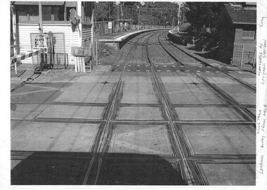
 Sunbury Family History and Heritage Society Inc.
Photograph, c 1970
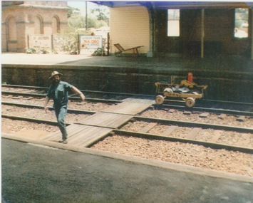
A railway maintenance person is crossing the railway tracks from Platform 2 to Platform 1 at Sunbury Station. There is a partial view of the historic brick water tower, which was used by the steam engines, on Platform 2.A coloured photograph of a maintenance man walking across a railway track at a station.sunbury railway station, water towers -
Marysville & District Historical Society
Document (item) - Research Document, Judith Vimpani, Hermit of the Cumberland Goldfield-George Ernest Locke, 2020
An account of the life of George Ernest Locke who was a gold miner on the Yarra Track near Marysville in Victoria.An account of the life of George Ernest Locke who was a gold miner on the Yarra Track near Marysville in Victoria. George was a well-educated young man and had some success prospecting in the Cumberland area before partnering with William Chester with whom he opened the Golden Bower gold mine in 1896. George and William then discovered a second reef which they named the Silver Bower mine. George lived in a log cabin in the Cumberland reserve and was known to be a loner. He was clever with his money and chose not to have a bank account in Marysville, where everyone would learn about his financial status. He banked at the ES&A in Fitzroy and at the time of his death in 1941 he had accumulated the princely sum of three hundred and sixty pounds. George Locke was known as "the Hermit of Cumberland Valley" and lived in his humpy until his last few days during which he moved into a Forest Commission's patrol hut because his old humpy had started to fall to pieces. When George passed away at the age of 81 years he had not visited Marysville for over 14 years. george ernest locke, gold miner, gold mining, yarra track, william chester, golden bower mine, cumberland goldfield, silver bower mine, chesterville, marysville, victoria, jackie lewis, baron somers, big tree, picea sitchensis exotic, box hill cemetery, john edward locke, annie caroline locke, hermit of the cumberland valley -
Whitehorse Historical Society Inc.
Map, Shires of Boroondara, Nunawading, C1856
Photocopy of part of very early map covering parts of Boroondara and Nunawading.Photocopy of part of very early map covering parts of Boroondara and Nunawading. Marks old tracks on lines of Whitehorse and Canterbury Roads.Photocopy of part of very early map covering parts of Boroondara and Nunawading.maps, shire of nunawading, shire of boroondara, barkers track, deep creek, nunawading -
 Melbourne Tram Museum
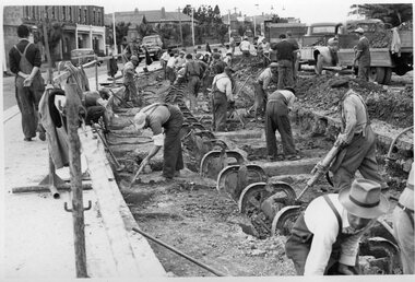
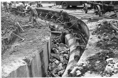
Photograph - Black and White - demolishing cable tram track Smith St and Queens Parade 1954/55
The photograph shows the demolition or removal of the cable tram track at the intersection of Smith St Gertrude St. Fitzroy. The workmen are excavating the former cable tram track The inbound cable tram track remains in position. The 1955 Annual Report notes that work commenced following the completion of the Queen's visit in March 1954 and that all work was done by day-labour. The track was opened to service in late June 1955. The second image is from a Melbourne and Metropolitan Board of Works plan (part) No. 1217 - Collingwood for the intersection, obtained for reference from the State Library of Victoria Collection of MMBW Plans. It shows the layout of the cables and the large sheave pit that the cable itself passed around. The trams were required to drop the cable from the grip prior to the entry to the curve and then coast around. Photographer is possibly Keith Kings.Yields information about the extent of work need to convert the former Northcote Cable tram route to Electric trams, the people and the methods used to undertake the work.Photograph - Black and White of the demolition of the cable tram track at the corner of Queens Parade - Smith St Clifton Hill.trams, tramways, cable trams, workmen, mmtb, demolition, track work, conversion, smith street, queens parade, clifton hill -
 Otway Districts Historical Society
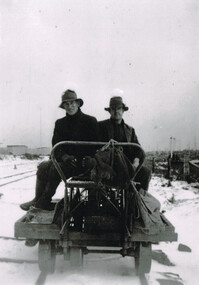
Photograph, Woosnan, Frank, Track gang at Beech Forest, c.1940, c.1940
At its peak the Colac-Beech Forest-Crowes railway employed more than 21 staff tending the lines that the trains ran over. Gangers (the men in charge of the track gangs) tended to be promoted into the Otways but many of their subordinate repairers were local recruits. A few of the men who worked on the original construction gangs of 1900-02 remained and obtained positions in the track gangs along the line, but these eased out over time. The track was maintained by seven three-man gangs based at Colac, Barongarook, Gellibrand, Banool, Beech Forest (where the second Beech Forest crew was based at Wyelangta), and Lavers Hill.Track gang on an NK wagon at Beech Forest, c.1940. Snow covers the ground. B/W.colac; beech forest; crowes; railway; track gangs; -
 Melbourne Tram Museum
Photograph - Black and White - demolishing cable tram track Smith and Gertrude Streets 1954/55
The photograph shows the demolition or removal of the cable tram track at the intersection of Smith Street and Gertrude St Fitzroy, 1954/55. Photo shows the workmen excavating and demolishing parts of the massive infrastructure needed at this curve to enable cable trams to pass around the sharp curve, still one of the sharpest on today's Melbourne tram system. The outside cable tram track remains in position. The MMBW plan shows a large cable sheave pit on the outside of the curve. The 1955 Annual Report notes that work commenced following the completion of the Queen's visit in March 1954 and that all work was done by day-labour. The track was opened to service in late June 1955. Photographer is possibly Keith Kings.Yields information about the extent of work need to convert the former Northcote Cable tram route to Electric trams, the people, the extent of the original construction and the methods used to undertake the work.Photograph - Black and White - demolishing cable tram track Smith and Gertrude Streets 1954/55trams, tramways, cable trams, workmen, mmtb, demolition, track work, conversion, smith street, gertrude street, fitzroy -
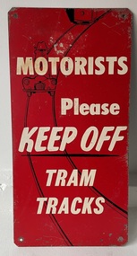 Melbourne Tram Museum
Sign - "Motorists Please Keep Off Tram Tracks"
Used by the MMTB in an attempt to keep tram tracks clear of motor cars. It seldom worked. Signs would have been fixed to the ends of a tram so it could be seen by motorists. See Item 6088 for another version.Demonstrates the methods the MMTB to ask motorists to keep tram tracks clear during the 1950's and 1960's.Sign - Zincalume steel sheet, with four holes in angled or trimmed corners asking "Motorists Please Keep Off Tram Tracks" Has the image of a motor car on the tram tracks with the outline of a tram following.tram stop, signs, mmtb, traffic control, trams, tramways -
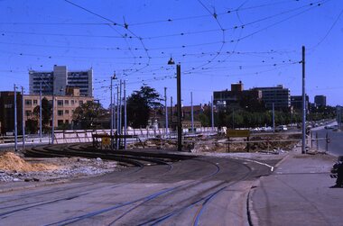 Melbourne Tram Museum
Slide - Set of 2, Keith Kings, 24/12/1967 12:00:00 AM
Set of two 35mm Kodak white cardboard colour slide by Keith Kings of 24/12/1967 - .1 - St Kilda Junction, looking north along St Kilda Road, showing the nature of the diversion from the junction for Wellington St. .2 - Dandenong Road, showing the track diversion work for Dandenong Road/Queensway, Windsor.Keith Kings stamp and number "15-1" and "15-5"", with details of exposure. .1 - SW6 car on temporary track at St Kilda Junction looking north from turnout during freeway work .2 - Dandenong Road west from Hornsby St with section of straight track ready to replace curves onto new b.v.w. track to Chapel St - 907 coming off soon to be abandoned street track.trams, tramways, st kilda junction, trackwork, road works, dandenong road, queensway, tram 907 -
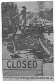 Ballarat Tramway Museum
Newspaper - Cutting - track removal Ballarat 1972, The Courier Ballarat
The newspaper cutting shows the nature of the track removal in Lydiard St North, Ballarat following closure of the SEC operated tramway system. Cutting not dated. Date based on an Tender advert on the rear, July 1972.Demonstrates the method of track removal, most likely by the Country Roads Board July 1972 Cutting from The Courier, Ballarat.Newspaper cutting - Cutting - track removal Ballarat 1972, Lydiard St North. track removal, lydiard st north, ballarat, tramways -
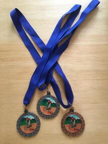 Geelong Cycling Club
Medals, 2002
Medals were presented by the Geelong West Cycling Club until the year 2002.Medals have always been given as recognition of achievement in competitive events.Medals in bronze and silver metal conglomerate. The front depicts an olive wreath around the circumference, and has a racing cyclist painted on an enamel disk in the centre. On the reverse side, inscription of the winner of the Women's Track Championships for 2002 appears inside an olive wreath decoration. "GWCC/Track Championships/Scratch Race/Women/Yolanda Russell/2002/Sprints/Time Trial"gwcc; track championships; scratch race; women; yolanda russell; 2002; sprints; time trial; -
 Marysville & District Historical Society
Photograph (item) - Colour photograph, 31-12-2008
A digital copy of a colour photograph of the timber tramway bridge along the Michaeldene Walking Track near Marysville in Victoria.A digital copy of a colour photograph of the timber tramway bridge along the Michaeldene Walking Track near Marysville in Victoria. The Michaeldene Trail to Taggerty River Lookout is a 4.3 kilometer lightly trafficked loop trail located near Marysville, Victoria. The track is one of several walking tracks located in and around Marysville in Victoria.timber tramway, michaeldene walking track, marysville, victoria, walking track -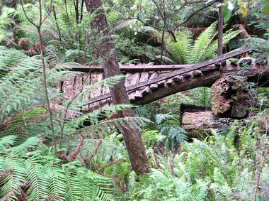
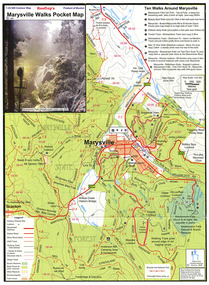 Marysville & District Historical Society
Map (Item) - Pocket map, Rooftop Mapping Services, Rooftop's Marysville Walks Pocket Map, 01-2009
A pocket map of ten walking tracks in an around Marysville. This map was published by Rooftop Mapping Services in January 2009.A pocket map of ten walking tracks in an around Marysville.marysville, victoria, australia, rooftop mapping services, steavenson falls, steavenson falls car park walk, beauty spot walk, marysville to el kanah guest house walk, gilberts gully walk, michaeldene track, man 'o' war walk, tree fern gully walk, marysville to woods lookout to mount gordon walk, keppels lookout walk -
 Marysville & District Historical Society
Photograph (item) - Black and white photograph, Rose Stereograph Company, Track to Cora Lynn Falls, Marysville, 1913-1967
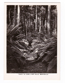
An early black and white photograph of the track to the Cora Lynn Falls in Marysville, Victoria.An early black and white photograph of the track to the Cora Lynn Falls in Marysville in Victoria. These falls are located on the Marysville-Wood's Point Road. Cambarville is notable for its giant mountain ash (Eucalyptus regnans) trees within the Cumberland Memorial Scenic Reserve, and relics from former sawmills and gold mining. The Big Culvert is located nearby on the Marysville - Woods Point Road, which was historically part of the Yarra Track. Cambarville was established as a timber mill town in the 1940s. Timber mill owners A Cameron and FJ Barton named Cambarville. They established the mill to salvage timber from trees destroyed in the 1939 bushfires. Cambarville was impacted by the 2009 Black Saturday bushfires and any remaining structures were destroyed. The photograph was also used to produce the Rose Series postcard P. 4958.marysville, victoria, photograph, cora lynn falls, waterfalls, p. 4958, rose series postcard, rose stereograph company, souvenir, cambarville, marysville-wood's point road, eucalyptus regnans, cumberland memorial scenic reserve, mining, big culvert, yarra track, a cameron, fj barton, 1939 bushfires, 2009 black saturday bushfires, timber mills -
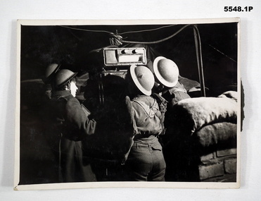 Bendigo Military Museum
Photograph
All photos of female British Army soldiers manning Air Defence Stations protecting Air Field from enemy attack using range finding equipment and predictors tracking incoming aircraft. Related to Beryl Scrimshaw (Morrel) of British Army. refer Cat No.304P & 315. All black and white photos of female British soldiers manning Air Defence Units. 1. Soldiers using prediction at night to track aircraft. 2. Soldiers in British Uniform at night using range finder to track aircraft. 3. Soldiers in British Uniform at night using range finder to track aircraft.On back - stamp of "Manchester Guardian & Evening News" Photo 1 also has description "Predictor". Photo 2 has description "Aircraft Spotter".aircraft defence, female soldiers, british army -
 Marysville & District Historical Society
Photograph (item) - Colour photograph, Pre 2009
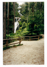
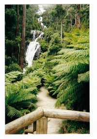
A colour photograph of the walking track leading to Steavenson Falls in Marysville in Victoria.A colour photograph of the walking track leading to Steavenson Falls in Marysville in Victoria. The Steavenson Falls is named after the Victorian Assistant Commissioner of Roads and Bridges, John Steavenson who arrived in Victoria in the early 1860s.Munroesteavenson falls, waterfalls, marysville, victoria, john steavenson -
 Marysville & District Historical Society
Photograph (item) - Colour photograph, Pre 2009
A colour photograph of the walking track leading to Steavenson Falls in Marysville in Victoria.A colour photograph of the walking track leading to Steavenson Falls in Marysville in Victoria. The Steavenson Falls is named after the Victorian Assistant Commissioner of Roads and Bridges, John Steavenson who arrived in Victoria in the early 1860s.Munroesteavenson falls, waterfalls, marysville, victoria, john steavenson -
 Marysville & District Historical Society
Photograph (item) - Black and white photograph, Rose Stereograph Company, Track to Cora Lynn Falls, Marysville, 1913-1967
An early black and white photograph of the track to the Cora Lynn Falls near Marysville, Victoria.An early black and white photograph of the track to the Cora Lynn Falls near Marysville in Victoria. These falls are located on the Marysville-Wood's Point Road. Cambarville is notable for its giant mountain ash (Eucalyptus regnans) trees within the Cumberland Memorial Scenic Reserve, and relics from former sawmills and gold mining. The Big Culvert is located nearby on the Marysville - Woods Point Road, which was historically part of the Yarra Track. Cambarville was established as a timber mill town in the 1940s. Timber mill owners A Cameron and FJ Barton named Cambarville. They established the mill to salvage timber from trees destroyed in the 1939 bushfires. Cambarville was impacted by the 2009 Black Saturday bushfires and any remaining structures were destroyed. The photograph was also used to produce the Rose Series postcard P. 4958.marysville, victoria, photograph, cora lynn falls, waterfalls, p. 4958, rose series postcard, rose stereograph company, souvenir, cambarville, marysville-wood's point road, eucalyptus regnans, cumberland memorial scenic reserve, mining, big culvert, yarra track, a cameron, fj barton, 1939 bushfires, 2009 black saturday bushfires, timber mills -
 Marysville & District Historical Society
Photograph (Item) - Black and white photograph, The "Scandinavians' - (Deserted), c1900
An early black and white photograph of The Scandinavian's Hotel and Boarding House along the Yarra Track.An early black and white photograph of The Scandinavian's Hotel and Boarding House along the Yarra Track. The Yarra Track is the former name of the gold fields road from Healesville to the Woods Point and Jordan Goldfields, in Victoria, Australia. A direct route via the Yarra River and the Great Divide was discovered by Rieck in September 1862 and became known as the Yarra Track. Early in 1863, the Victorian Government decided to construct a 193-kilometre (120 mile) road along the route. Its original width varied between 4 and 6 metres (12 and 20 feet), and was designed to accommodate horse-drawn vehicles. The Track involved the climbing of the Black Spur, descent into the Acheron Valley, and then through Marysville to the Cumberland where it followed the existing route.ARMSTRONG COLLECTION 42 STATION STREET/ SANDRINGHAM 3191/ TEL. (03) 9521 5442/ IAN M.L. ARMSTRONG OAMthe scandinavians', yarra track, healesville, wood's point, jordan goldfields, victoria, yarra river, great divide, reick, black spur, acheron valley, marysville, cumberland creek