Showing 236 items matching "underground mining"
-
 Bendigo Historical Society Inc.
Document - ALBERT RICHARDSON COLLECTION: HISTORICAL RECORDS OF BENDIGO MINES
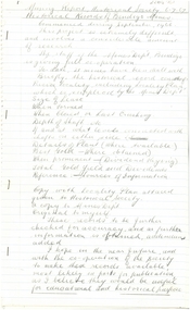
Copy of 3-page handwritten document by Albert Richardson. Written on top of page one: 'Mining Report Historical Society 6.7.67. Historical Records of Bendigo Mines' which outlines a project undertaken by Albert and the Historical Society to write a description of each Bendigo mine, showing location, plant, gold gained, depth of shaft etc. The objective was to publish this information in a book for 'educational and historical purpose'. The paper further describes a public meeting to outline the BHS proposal to 'preserve a gold mine with all equipment both surface and underground, a crushing battery, a windlass, a whip and a whim to be stored, as far as possible in correct position. For tourists, local residents and educational purposes this should illustrate what Bendigo workers in Bendigo foundries and Bendigo citizens generally, achieved in making this city a world-famous gold mining centre. That Victoria Hill be made available and developed for the benefit of tourists and local residents' Members of the BHS involved: J. Hattam President, E. Clarke, Neil Murray, A. LLewellyn.bendigo, mining, bendigo gold mines -
 Bendigo Historical Society Inc.
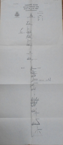
Document - UNDERGROUND SURVEY OF BENDIGO MINES
Two page document, 'Underground survey of Bendigo, report on Constellation Company's Mine on northern extension of the Garden Gully line of reef. Report on the New Chum Railway Reserve Company and the Shenandoah Company, the New Chum Railway Co being immediately south and the Shenandoah Co immediately north of the railway line. Two maps Constellation Co. Mine shaft and New Chum Railway and Shenandoah auriferous reef below 2700 feet.Jems Stirling, geologist and W.H Cundy Underground Surveyor, Department of Minesbendigo, mining, garden gully line of reef mines -
 Stawell Historical Society Inc
Map, Underground Survey of the Principal Mines of Stawell 1879, 1879
Pleasant Creek & Newington, Prince Patrick, Prince Alfred, Pioneer and Galatea, Pleasant Creek Cross Reef No. 1&2, Magdala, Old Shaft, Extended Cross Reef, Crown Cross, Great Northern, Sloanes & Scotchmans, South Cross, 10 & 11 United Scotchmans South Cross, Scotchmans Shafts, North Scothmans, West Scotchmans, Emerald Isle & Rose of Denmark, Albion, South Scotchmans, Newington & Pleasant Creek, Pleasant Creek Cross Reef, Moonlight, Extended Cross Reef, Crown cross United, Great Northern ShaftVery large Map on cloth backing, showing cross sections of mines.Surveyed by H.C. Bates. Drawn by Arthur Edwards. October 30th 1879. Scales 120 feet to an inchmining, gold -
 Bendigo Historical Society Inc.
Plan - MARKS COLLECTION: PLAN OF UNDERGROUND SURVEY G. DENNIS MINE
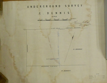
Plan drawn on heavy parchment 'underground survey G. Dennis' printed on top of plan. Plan shows boundary lines and peg site. P. Bonati claim marked on bottom of plan. B. Letter with plan on letterhead 'City of Sandhurst, Town Hall, July 2nd. 1873' Addressed to Mr. George Dennis, Sir, In reply to your letter of the 19th. ulto I am empowered to state that subject to the formation of the road referred to, your existing rights are conserved, and the council will undertake not to object to the renewal of your lease. The only conditions being that you shall not sink a shaft in the street or attempt to obstruct it when formed. I have the honor to be, Sir, your obedient servant, Geo Fletcher, Town Clerk.bendigo, mining, g. dennis claim -
 Bendigo Historical Society Inc.
Photograph - Carshalton Gold Mine Scraper, 1935
Significant to mining history of Bendigo.Black and white photograph : image shows underground position of scraper at No. 5 plat. Written in pencil on back of photograph in pencil: 'Carshalton No. 5 plat showing fixed scraper in position 17.9.35 'carshalton gold mine -
Clunes Museum
Functional object - CANDLESTICK HOLDER
Metal candle holder on a spike to drive into wall to hold candle during mining operationclunes township and mining, mining, gold mining in clunes, victoria, australia, illumination in underground gold mines -
 Stawell Historical Society Inc
Photograph, Amalgamated Scotchmans Mine Workings Stawell
Black and white photograph of Amalgamated Scotchman Mine workings Stawell. Western Mining Operations - because the wooden props have been immersed in water for a century they are well preserved. Underground view down mine shaft or tunnel showing timbers holding rock walls. This photograph is in a brown cover.stawell -
 Stawell Historical Society Inc
Drawing, North Cross Reef mine in Stawell -- Sketches
Photograph of three sketches of North Cross Reef Stawell. c 1874. Photo 1. No 3 Level, Ceiling of tunnel timbered rail line and truck - a workman. Photo 2. The Vertical reef. Photo 3. The Flat Reef. Examples of what the miners were like underground. Reproduction Rights Reserved - Copied by State Library of Victoria.Black and white photograph of three mining scenes (sketched) showing examples of wood timbered underground tunnels.North Cross Reef Stawell. No.3. Level (photo 1). The vertical reef. (photo 2). Workings on the flat reef. (photo 3).stawell mining -
 Bendigo Historical Society Inc.
Map - UNDERGROUND SECTION OF 3 MINES
Underground section of three mines - Shaft No 94, New Chum United Co, Cross Section No 89 - Shaft No 93, Lansell's 222 (DENIS), Cross Section No 87 - Shaft No 92A (New Shaft), Lansell's 222, Cross Section No 86. Map shows depth of cross sections below the sill and stone encountered. Poppet legs are drawn at the top of the shafts. Lansell's 222 Shaft No 92A has measurements penciled in.mining, parish map, new chum united, lansell's 222 -
 Bendigo Historical Society Inc.
Map - GREAT EXTENDED HUSTLER'S MINE - LONGITUDINAL SECTION OF THE GREAT EXTENDED HUSTLER'S MINE
Longitudinal Section of the Great Extended Hustler's Mine on the Hustler's Line of Reefs. Bulletin No 33, Plate No XIII. Map shows the Hustler's Tribute, 2 Old Shafts, Great Extended Hustler's Shaft, Latham & Watson's Shaft and Ironbark Gully. Datum Line 750 feet above Sea Level. Poppet Legs on the surface and Sill of Shaft 788.99 feet above Sea Level. Levels and their depths are shown and some geographical features. Some amounts of gold mined mentioned. Geological Survey of Victoria emblem and signed by H A Whitelaw, Underground Survey Office Bendigo, September 1913. Note - Plates 4, 8, 13,20, 26 & 31 form a Longitudinal Section from Fortuna Hustlers to Hustler's Consols Mine. mining, parish map, great extended hustler's mine, geological survey of victoria, underground survey office bendigo, h a whitelaw, hustler's tribute, old shaft, great extended hustler's shaft, latham & watson's shaft, ironbark gully -
 Bendigo Historical Society Inc.
Map - GREAT EXTENDED HUSTLER'S MINE - TRANSVERSE SECTION OF THE GREAT EXTENDED HUSTLER'S MINE
Transverse Section of the Great Extended Hustler's Mine on the Hustler's Line of Reef. Bulletin No 33, Plate No XII. Shows Poppet legs at the surface and Sill of Shaft at 788.99 feet above Sea Level, Cross Cuts and their depths, stone and geographical features encountered and their references and a number of enlarged drawing of sections of the crosscuts, Geological Survey of Victoria emblem and signed by H A Whitelaw, Underground Survey Office Bendigo, September 1913. The depths of crosscuts to No 21 were taken from plans of surveys by Mr. Walker and Mr. Craven, noted under Reference. Another note: This Saddle Reef is sketched from Mr. Walker's plan. Dividends amounting to 360,000 pounds were obtained from it. mining, parish map, great extended hustler's mine, transverse section of the great extended hustler's mine, old shaft, mr walker, mr craven, geological survey of victoria, underground survey office bendigo, h a whitelaw -
 Bendigo Historical Society Inc.
Map - GREAT EXTENDED HUSTLER'S MINE - PLAN OF THE GREAT EXTENDED HUSTLER'S MINE
Plan of the Great Extended Hustler's Mine on the Hustler's Line of Reefs, Bendigo. Bulletin No 33, Plate No X. Lease No 7382. Plan has map of streets. Mine was located in the block bounded by Langston and Anderson Streets and was between the Hustler's Anticline at Surface and the Lightning Hill Anticline at Surface. Latham & Watson's Shaft is also mentioned. Levels are numbered and a table shows the Levels and their Depths. Geological Survey of Victoria. Signed by H A Whitelaw, Underground Survey Office, Bendigo, September 1913. This item has not been scanned or photographed.mining, parish map, great extended hustler's mine, hustler's line of reefs, mining lease no 7382, geological survey of victoria, underground survey office bendigo, h a whitelaw, latham & watson's shaft -
 Bendigo Historical Society Inc.
Map - GREAT EXTENDED HUSTLER'S MINE - PLAN OF THE GREAT EXTENDED HUSTLER'S MINE
Plan of the Great Extended Hustler's Mine. Bulletin No 33, Plate No XI. Shows No 2 Shaft, Latham & Watson's Shaft, levels and their depths and some geographical features. Geographical Survey of Victoria emblem and signed by H A Whitelaw, Underground Survey Office, Bendigo, September 1913. Has reference to photos.mining, parish map, great extended hustler's mine, no 2 shaft, latham & watson's shaft, geological survey of victoria, underground survey office bendigo, h a whitelaw -
 Bendigo Historical Society Inc.
Map - FORTUNA HUSTLER'S MINE - TRANSVERSE SECTION OF THE FORTUNA HUSTLER'S MINE
Transverse Section of the Fortuna Hustler's Mine on the Hustler's Line of Reef, Bendigo. Bulletin No 33, Plate No III. Drawing shows poppet legs on the surface and Sill of Shaft 745.38 feet above Sea Level. Shows levels and their depths, geographical features and stone encountered. Reference table to stone and geographical features. Geographical Survey of Victoria emblem. Signed by H A Whitelaw, Underground Survey Office, Bendigo. mining, fortuna hustler's mine, hustler's line of reef, geological survey of victoria, underground survey office bendigo, h a whitelaw -
 Bendigo Historical Society Inc.
Map - FORTUNA HUSTLER'S MINE - LONGITUDINAL SECTION OF THE FORTUNA HUSTLER'S MINE
Longitudinal Section of the Fortuna Hustler's Mine on the Hustler's Line of Reef, Bendigo. Bulletin No 33, Plate No IV. Shows poppet legs at the surface level, Datum Line 750 feet above Sea Level, levels and their depths, the amount of gold per ton and some geographical features. Geological Survey of Victoria emblem and signed by H A Whitelaw, Underground Survey Office, Bendigo. Note - Plates 4, 8, 13, 20, 26 & 31 form a Longitudinal Section from Fortuna Hustler's to Hustler's Consols Mine. mining, parish map, fortuna hustler's mine, longitudinal section of the fortuna hustler's mine, geological survey of victoria, h a whitelaw, underground survey office bendigo, hustler's line of reef, hustler's consols mine -
 Bendigo Historical Society Inc.
Map - FORTUNA HUSTLER'S MINE - PLAN OF THE FORTUNA HUSTLER'S MINE
Plan of the Fortuna Hustler's Mine, Bulletin No 33, Plate No II. Geological Survey of Victoria. Signed by H A Whitelaw, Underground Survey Office Bendigo, September 1913. Map shows levels and depths. There are smaller drawings of some sections of some levels. mining, parish map, fortuna hustler's mine, plan of the fortuna hustler's mine, geological survey of victoria, h a whitelaw, underground survey office bendigo -
 Bendigo Historical Society Inc.
Map - HUSTLER'S REEF MINE - EAST & WEST CROSS-CUTS, NORTH & SOUTH OF SHAFT
East & West Crosscuts, North & South of Shaft, Hustler's Reef Mine Bulletin No 33, Plate No XIX. Map shows main shaft and smaller drawing of section with different stone encountered. Also gives location in relation to the shaft, e. g. 225'E & 150'S of Shaft. Reference diagram to show the different stone and features encountered. Geological Survey of Victoria emblem. Signed by H A Whitelaw, Underground Survey Office Bendigo, September 1913. mining, parish map, hustler's reef mine, east & west cross-cuts north & south of shaft, geological survey of victoria, h a whitelaw, underground survey office bendigo -
 Bendigo Historical Society Inc.
Document - LITTLE 180 MINE - NOTES ON THE LITTLE 180 MINE
Three handwritten and three typed copies of notes on the Little 180 Mine. Notes include locality, underground connections, depth, plant, historical notes best gold, gold yield and dividends. References are in the left margin. Albert Richardson Collectiondocument, gold, little 180 mine, little 180 mine, notes on the little 180 mine, sheepshead line of reef, john brown factory, central red white & blue, central blue, ironbark south mine, rae's hill, a roberts & sons bendigo, s h johnson stratford, deborah consolidated mine, big 180 mine, new chum syncline mine, george lansell, new chum line of reef, a richardson, bendigo branch of royal historical society, mine's dept transverse and longitudinal sections little 180 mine, catalogue mining sales j h curnow, mine's dept special edition australian mining standard1/6/1899, mines dept booklet bendigo goldfield 1936, mine's dept quarterly and annual reports -
 Bendigo Historical Society Inc.
Map - HUSTLER'S REEF MINE - TRANSVERSE SECTION OF THE HUSTLER'S REEF MINE
Transverse Section of the Hustler's Reef Mine on the Hustler's Line of Reefs. Bulletin No 33, Plate No XVIII. Shows cross-cuts and their depth, different types of stone and geological features encountered. Drawing of poppet legs at the surface and Sill of Shaft 756.39 ft above Sea Level. Reference Table shows key to the different stone and geographical features encountered. Geographical Survey of Victoria. Signed by H A Whitelaw, Underground Survey Office, Bendigo, September 1913. Thompson's Reef is also mentioned on the map. mining, hustler's reef mine, transverse section of the hustler's reef mine, geological survey of victoria, h a whitelaw, underground survey office bendigo, thompson's reef. -
 Bendigo Historical Society Inc.
Map - HUSTLER'S CONSOLS MINE - TRANSVERSE SECTION OF THE HUSTLER'S CONSOLS MINE
Transverse Section of the Hustler's Consols Mine Bulletin No 33, Plate No XXXIII. Map shows poppet legs at the surface and Sill of Shaft 779.42 feet above Sea Level. Shows the different levels and their depths and the different stone and geographical features encountered. Has larger drawing of Section A - B. Geographical Survey of Victoria. Signed by H A Whitelaw, Underground Survey Office Bendigo, September 1913. mining, parish map, hustler's consols mine, transverse section of the hustler's consols mine, geological survey of victoria, underground survey office bendigo, h a whitelaw -
Bendigo Historical Society Inc.
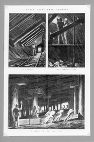
Photograph - Great Extended Hustlers Gold Mine Sandhurst, April, 2014
Seven men were killed at the Great Extended Hustler's mine disaster on 2nd May 1914 by an explosion of dynamite occurring as the men were waiting at the plat to ascend the mine at the end of their shift. No blame was attached to anyone in the findings of the inquisition. It was unknown what caused the dynamite to explode. This document formed part of the research done at the time by Bendigo Historical Society, of the 100 years commemoration of the mine disaster, held at Hustler's Hill in 2014. Two pages of photocopies of images from the 'Australasian Sketcher' May 17th. 1873, of the Great Extended Hustlers Gold Mine Sandhurst. First page: across top of image 'Quartz Mining - The Great Extended Hustlers Mine, Sandhurst'. Across bottom of image ' General View of the Principal Shafts'. Image shows mine buildings, trestle way, mine dam in foreground, poppet head in background. Mining chimneys in background. Second page: same view as above with five small images of mine operations below; men underground, men in mine cate, man pushing ore truck. great extended hustlers, goldmining, accident, 1873 -
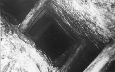
Bendigo Historical Society Inc.
Photograph - AUSTIN COLLECTION: Central Deborah Gold Mine Lift Shaft
Central Deborah Gold Mine history: At its peak, Central Deborah Gold Mine reached a depth of 412 metres. It has 17 separate levels and 15 kilometres of drives and cross cuts (tunnels). The Central Deborah was very much a hands-on mine and the conditions that the miners worked in would be considered shocking by today's standards – being lowered underground in a cage with only two sides, often working ankle to knee deep in water, filling up to 32 ore trucks a shift by hand which were then pushed a mile or more along rails in the drives, working by carbide lamp, breathing in the fumes and rock dust and communication by bells. Geez, they were ironmen. However, at the time working conditions were considered to be among the best on the goldfields at Central Deborah, after all it was one of the only mines that had hot showers. Following Central Deborah Gold Mine's closure, the Bendigo skyline began to noticeably change. Obvious remnants of mining such as poppet heads, engine rooms, service quarters, battery houses and chimneys were steadily disappearing. After intense lobbying by the local community, the Bendigo City Council purchased the still very much intact Central Deborah Gold Mine in 1970 for a mere $6,000 to ensure that a vital link to Bendigo's historic golden past was maintained. The Bendigo Trust was then formed to oversee the operations of the Central Deborah Gold Mine, which led to the surface of the mine being opened to the public in 1971. Initially the surface was open for just 12 hours a week and as the demand for viewing a part of Bendigo's history increased, so did the opening hours. In 1974 the mine was gazetted as a Public Historical Purposes Reserve and attracted such visitors as H.R.H Prince Charles. By far the greatest shortcoming at this stage was that no one could view the underground workings, as these had become flooded. After what could only be described as a monumental effort by everyone involved, Level 2 of the mine was officially opened to the public by the Premier of Victoria, the Honourable John Cain, on 20 June 1986, which brought to fruition a long standing dream.Black and white photograph, looking from bottom of lift shaft towards the surface; light visible at top of shaft. Lift cables and safety mesh on sides of shaft. gold mining, central deborah gold mine, ray beer, mine manager -
Bendigo Historical Society Inc.
Photograph - AUSTIN COLLECTION: Central Deborah Gold Mine, Possibly 1990's
Central Deborah Gold Mine history: At its peak, Central Deborah Gold Mine reached a depth of 412 metres. It has 17 separate levels and 15 kilometres of drives and cross cuts (tunnels). The Central Deborah was very much a hands-on mine and the conditions that the miners worked in would be considered shocking by today's standards – being lowered underground in a cage with only two sides, often working ankle to knee deep in water, filling up to 32 ore trucks a shift by hand which were then pushed a mile or more along rails in the drives, working by carbide lamp, breathing in the fumes and rock dust and communication by bells. Geez, they were ironmen. However, at the time working conditions were considered to be among the best on the goldfields at Central Deborah, after all it was one of the only mines that had hot showers. Following Central Deborah Gold Mine's closure, the Bendigo skyline began to noticeably change. Obvious remnants of mining such as poppet heads, engine rooms, service quarters, battery houses and chimneys were steadily disappearing. After intense lobbying by the local community, the Bendigo City Council purchased the still very much intact Central Deborah Gold Mine in 1970 for a mere $6,000 to ensure that a vital link to Bendigo's historic golden past was maintained. The Bendigo Trust was then formed to oversee the operations of the Central Deborah Gold Mine, which led to the surface of the mine being opened to the public in 1971. Initially the surface was open for just 12 hours a week and as the demand for viewing a part of Bendigo's history increased, so did the opening hours. In 1974 the mine was gazetted as a Public Historical Purposes Reserve and attracted such visitors as H.R.H Prince Charles. By far the greatest shortcoming at this stage was that no one could view the underground workings, as these had become flooded. After what could only be described as a monumental effort by everyone involved, Level 2 of the mine was officially opened to the public by the Premier of Victoria, the Honourable John Cain, on 20 June 1986, which brought to fruition a long standing dream.Black and white photograph. Two men with hard hats and lights, inspecting quartz outcrop on wall of drive at Central Deborah Gold Mine.gold mining, central deborah gold mine, ray beer, mine manager -
Bendigo Historical Society Inc.
Photograph - AUSTIN COLLECTION: Operating rock drill, Central Deborah Gold Mine, Possibly 1990's
Central Deborah Gold Mine history: At its peak, Central Deborah Gold Mine reached a depth of 412 metres. It has 17 separate levels and 15 kilometres of drives and cross cuts (tunnels). The Central Deborah was very much a hands-on mine and the conditions that the miners worked in would be considered shocking by today's standards – being lowered underground in a cage with only two sides, often working ankle to knee deep in water, filling up to 32 ore trucks a shift by hand which were then pushed a mile or more along rails in the drives, working by carbide lamp, breathing in the fumes and rock dust and communication by bells. Geez, they were ironmen. However, at the time working conditions were considered to be among the best on the goldfields at Central Deborah, after all it was one of the only mines that had hot showers. Following Central Deborah Gold Mine's closure, the Bendigo skyline began to noticeably change. Obvious remnants of mining such as poppet heads, engine rooms, service quarters, battery houses and chimneys were steadily disappearing. After intense lobbying by the local community, the Bendigo City Council purchased the still very much intact Central Deborah Gold Mine in 1970 for a mere $6,000 to ensure that a vital link to Bendigo's historic golden past was maintained. The Bendigo Trust was then formed to oversee the operations of the Central Deborah Gold Mine, which led to the surface of the mine being opened to the public in 1971. Initially the surface was open for just 12 hours a week and as the demand for viewing a part of Bendigo's history increased, so did the opening hours. In 1974 the mine was gazetted as a Public Historical Purposes Reserve and attracted such visitors as H.R.H Prince Charles. By far the greatest shortcoming at this stage was that no one could view the underground workings, as these had become flooded. After what could only be described as a monumental effort by everyone involved, Level 2 of the mine was officially opened to the public by the Premier of Victoria, the Honourable John Cain, on 20 June 1986, which brought to fruition a long standing dream.Black and white photograph. Two men with hard hats and lights standing in front of underground rock surface at Central Deborah Gold Mine. Man on left hand side of image is operating a small rock drill. Man on right hand side is observing the procedure. gold mining, central deborah gold mine, rock drill, underground -
Bendigo Historical Society Inc.
Photograph - AUSTIN COLLECTION: Quartz vein, Central Deborah Gold Mine, Possibly 1990's
Black and white photograph. Underground miner, wearing hard hat and light, inspecting a quartz vein on the wall of a drive at the William's United Gold Mine, Eaglehawk. On back of photo: ' Ian Clark, 8" drill hole'and drill holegold mining, central deborah gold mine, underground, quartz vein, williams united gold mine, eaglehawk -
 Bendigo Historical Society Inc.
Photograph - Kangaroo Flat Gold Mine Collection: photo album 1998
Photo album, black cover, gold border. One hundred colour photos, some with annotations. Label on front of album: Portal, machinery, underground shots 1998; drilling in Deborah St.; mines rescue vehicle; various staff; E.E.S. Displays; Board Meeting 1998. Staff photos: Rob Charlton, pump at Red, White Blue Cons.; Andrew Breen Workshop Manager; John Cahill; Patrick O'Boyle Mine Rescue Vehicle; John Cahill; Ben Clayton; Ricky Hannah; April Westcott; Ivette Maggs site clerk McMahons; Wayne Woodward; Fiona Hunt; Steve Woodall.kangaroo flat gold mine, bendigo mining nl, new bendigo gold project, goldmining, personnel, doug buerger, colin burns, tarnagulla, new moon, displays, box cut, unity mining, aerial photos, 1998 -
 Bendigo Historical Society Inc.
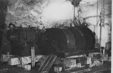
Photograph - Napoleon Sinking Winch, 1936
Significant to mining history of Bendigo.Black and white photograph: sinking winch machinery supported on concrete block, underground at the Napoleon (BML) gold mine. Two men, one standing at back of machinery left hand side, and one standing on concrete platform operating a pulley.Written in pencil on back of photograph : '....(illegible) sinking winch No. 10 plat Napoleon 15/9/36''napoleon gold mine, sinking winch, plat -
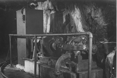 Bendigo Historical Society Inc.
Photograph - Napoleon Main Pump, 1936
Significant to mining history of Bendigo.Black and white photograph: pump machinery in underground at Napoleon (BML) Gold Mine. Image shows machinery, with steel control box at far left hand side. Safety rail in front of machinery. Rock wall behind. Written in pencil on back of photograph : '....(illegible) pump No. 10 plat Napoleon 15/9/36 ''napoleon gold mine, plat, pump -
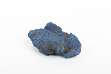 The Beechworth Burke Museum
Geological specimen - Azurite, Unknown
Azurite is a secondary copper mineral made by the weathering of copper sulphide ore deposits. Azurite is formed from copper, carbon, oxygen and hydrogen. There are over 45 forms of azurite that are more well-known, however over 100 forms have been found. Azurite is also commonly found together with Malachite, and Azurite is often psuedomorphed to Malachite. This specimen was found at the Great Cobar Copper Mine in New South Wales, which was founded in 1870. At the time it was one of the largest mining operations in the world. It was the largest copper mine in Australia and housed the southern hemisphere’s tallest chimney stack. The international price of copper collapsed at the end of World War 1 which led to the closure of the Great Cobar Mine on March 16th 1919. A year later on March 10th 1920 an underground fire in the CSA (Cornish, Scottish, Australian) mine started and burned for 16 years. The closure of the mine and the fire left thousands jobless and many people left the area. These were factors in Cobar facing a long stretch of poverty, until a boom in the 1960s led to the reopening of the mine. The mine still operates today, obtained by Metals Acquisition Limited in June 2023. Azurite is considered an uncommon mineral. Named for its deep blue colour, azurite was historically used for pigment making and as a gemstone, despite its softness. This specimen was donated to the Burke Museum between 1868-1880 as part of a larger collection of geological and mineral specimens. Many of the specimens in this collection were obtained as part of the Geological Survey of Victoria, which started in 1852. The Survey aimed to map the scientific makeup of the earth.A solid copper mineral with shades of darker blues almost covering it.burke museum, beechworth, indigo shire, beechworth museum, geological, geological specimen, mineralogy, cobar mines, great cobar copper mine, cobar mining, new south wales, azurite, azurite specimen -
Bendigo Historical Society Inc.
Booklet - Mines Act Regulations relating to Safety and Health, 1954
Booklet is an extract from the Victorian Government Gazette No 691, 11th August, 1954.Booklet, grey soft cover, fifty-five pages. On front cover: ' Victoria Mines Act, Regulations Relating to Safety and Health, Operative from 1st September 1954'. Regulations detailed in booklet include preliminary regulations, ventilation, winding and signals, ladders and travelling ways, safety and protection, sanitation and hygiene, explosives, underground locomotives including other tractive equipment, internal combustion engines and electricity in mines. ' Bendigo Historical Society' purple stamp inside front and back covergoldmining, mining, ventilation, winding and signals, ladders and travelling ways, safety and protection, sanitation and hygiene, explosives, underground locomotives including other tractive equipment, internal combustion engines, health and safety, safety regulations