Showing 213 items
matching warrandyte south
-
 Ringwood and District Historical Society
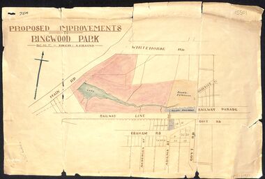
Map, Proposed Improvements to Ringwood Park (Ringwood Lake) dated 14 January 1927
Proposed Improvements to Ringwood Park (Ringwood Lake) dated 14 January 1927, signed Cr McCaskill. Main Road is Whitehorse Road (Maroondah Highway), and Mt Dandenong Road is incorrectly labelled Whitehorse Road. The map shows Rosedale Crescent and Railway Parade, both of which exist in 2024. On the bottom of the map, south of the railway line, showing proposed streets - Graham Road, Anderson Street and Adams Street - in preparation for the sale of the Theo Anderson property. That area is now Bedford Park. -
 Ringwood and District Historical Society
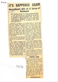
Newspaper, Newspaper articles detailing the gift of 17 acres of land south end of New Street, by Frank Pike of Heatherdale Road, for parkland
Newspaper articles detailing the gift of 17 acres of land south end of New Street, by Frank Pike of Heatherdale Road, for parkland. The new park will be called Pomona Park. It was later called Proclamation Park, used for athletics, baseball and cricket. -
 Ringwood and District Historical Society
Newspaper, Scrapbook Clipping, Library Collection, Ringwood, Victoria, `
``Newspaper clipping from The "Post" , 29-9-93 P2 Australian all overAustralian citizenship was granted to 45 Ringwood residents on Monday night in a ceremony at Ringwood Convention centre. The 37 adults and eight children came from South Africa, Britain, Nigeria, New Zealand, Hungary, the Philipines and Tonga. Mayor, Cr Margaret Cheevers welcomed the new citizens.` -
 Ringwood and District Historical Society
Newspaper, Scrapbook Clipping, Library Collection, Ringwood, Victoria, `
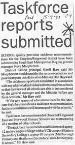
``Newspaper clipping from "The Post", 15-9-93, P9 School quality provision taskforce recommendations for the Croydon/Ringwood district have been submitted to South East Metropolitan General Manager Steve Macpherson. District Liaison proncipal Geoff Haw said Mr Macpherson would consider the recommendations and pass the reports onto Education Minister Don Hayward.` -
 Ringwood and District Historical Society
Newspaper, Scrapbook Clipping, Library Collection, Ringwood, Victoria, `
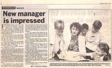
``Newspaper clipping from "The Mail", 1-03-1994 P1. SCHOOLS watch. New Manager is impressed. By Jodie Hawthorne Former Ringwood East and Norwood primary school students are settling well into their new schools, according to the new general manager of the south eastern region of the Directorate of School Education. Mrs Merril Haeusler, who toured Ringwood and Croydon last week, said the 300 students from the closed schools had made a smooth transition into their new schools.` -
 Ringwood and District Historical Society
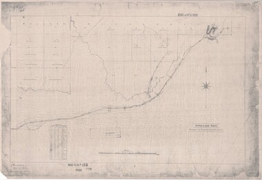
Map, Road Plan 108 - Gipps-land Road, Parishes of Bulleen and Warrandyte (Ringwood, Victoria) - 1855
Surveyor's map of the part of the main road from Melbourne to Gippsland following "Barker's Track" south of Mullum Mullum or Deep Creek. Map references include Roman numerals marking distances measured in Links between trees at turns in the road.Submitted to the Surveyor General (Signed) July 2nd 1855. -
 Ringwood and District Historical Society
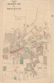
Map, Borough of Ringwood, Victoria - c.1950s
A0-size (approx) map of named streets and lot-numbered properties within Borough of Ringwood ward boundaries. Colour-coded key marking Land Under Control of Council, Factory Areas, and Business Areas.Scale: 8 chains to 1 inch. North Ward, East Ward, South Ward. -
 Ringwood and District Historical Society
Newspaper, Scrapbook Clipping, Library Collection, Ringwood, Victoria, `
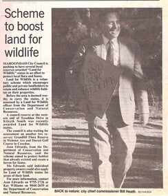
``Newspaper clipping from "The Mail", 4-7-95, P 6. NEWS WATCH- Scheme to boost land for wildlife Maroondah City Council is pushing to have several local reserves awarded "Land for Wildlife" status in an effort to protect local flora and fauna. A council reserve at the western end of Tereddan Drive in Kilsyth South was recently awarded Land for Wildlife Status` -
 Ringwood and District Historical Society
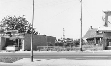
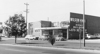
Photograph, Maroondah Highway West, Ringwood- 1969. Looking east from near Wantirna Road
Black and white photographWritten on back of photograph: "May 1969". Image shows 'Bank of New South Wales' on south side of highway. -
 Ringwood and District Historical Society
Photograph, Maroondah Highway West, Ringwood- 1969. Near Wantirna Road
Black and white photographWritten on back of photograph: "May 1969" Image shows 'National Bank', and 'Newman & Ritchie Estate Agents' on south side of Maroondah Highway. -
 Ringwood and District Historical Society
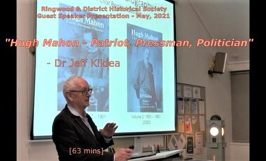
Mixed media - Video, RDHS Guest Speaker Presentation - "Hugh Mahon - Patriot, Pressman, Politician" - Dr Jeff Kildea
Digitised video (3.20GB) Duration: 63 minutes. Recorded May, 2021 (Video is available for viewing at Ringwood & District Historical Society Archives by appointment)Presenter: Dr Jeff Kildea is an Honorary Professor in Irish Studies at the University of New South Wales. In 2014 he held the Keith Cameron Chair of Australian History at University College Dublin. He is the author of numerous books and articles on the Irish in Australia including Hugh Mahon: Patriot, Pressman, Politician, Anchor Books Australia, Melbourne, 2017 (Vol 1) and 2020 (Vol 2). This talk examines the background to Mahon’s expulsion from parliament and how it led to his being ostracised by his fellow Australians including his neighbours at Ringwood. -
 Ringwood and District Historical Society
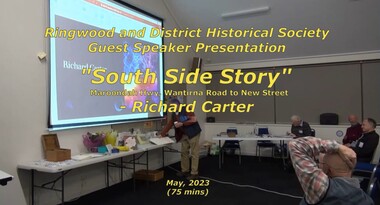
Mixed media - Video, RDHS Guest Speaker Presentation - "South Side Story - Maroondah Hwy, Wantirna Road to New Street" - Richard Carter
Digitised video (3.19GB) Duration: 75 minutes. Recorded May, 2023 (Video is available for viewing at Ringwood & District Historical Society Archives by appointment)Presenter: Past-President of RDHS, Richard Carter, is the guru when it comes to researching properties. South Side Story examines the often forgotten - but important - part of Ringwood from Wantirna Road to Olive Grove on the southern side of Maroondah Highway, Ringwood, Victoria. -
 Ringwood and District Historical Society
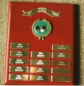
Photograph, Ringwood Bowls Club - Shield presented by Probus Club of Ringwood- 1986. North V's South
Coloured photographShield contains winners from 1982 to 1995. -
 Ringwood and District Historical Society
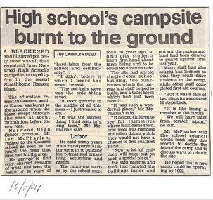
Newspaper - Clipping, Norwood High School/Secondary College, Ringwood, Victoria - School campsite fire, 1991
Local newspaper article, 10 January, 1991 by Carolyn Deed, reporting buildings at the school's country retreat at Gooram, south of Euroa, were burnt to the ground when a blaze swept through the area. Norwood High School principal, Mr Ian McPharlan, rushed to the site as soon as he heard the news that fires had hit the area and arrived to find only charred remains of what had been the result of 20 years of hard labor from the school and community. -
 Ringwood and District Historical Society
Memorabilia - 3 pages about Sir Walter Scott and Christie's Auction house, Three pages about Sir walter Scott and Christies Auction house.collected by Archie Harker
. Archie Harker worked in a publishing so would have had an interest in literary figures.1. Page listing the works of Sir Walter Scott. 2. Hand written page with Christies Auctions of 1, Darling Street South Yarra and some Scott details. 3.Printed page from newspaper (undated or named) notes about Scott in article titled Education Briefs. Query - of no relevance to RDHS? -
 Robin Boyd Foundation
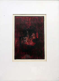
Work on paper - Lithograph, Grahame King, Red and Black, 1965
This artwork is thought to have come from Robin Boyd's East Melbourne office after his death in 1971. Robin Boyd was a long time friend of Grahame King and sculptor Inge King and he designed their Warrandyte home and studio in three stages between 1952 and 1964. This artwork may have been a gift from them.Red and black abstract composition.Signature and date on lower right. 3/20grahame king, inge king, robin boyd, walsh st artwork, ohm2022, ohm2022_22 -
 Robin Boyd Foundation
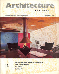
Journal, Architecture and Arts (2 copies), Aug-54
This features a photo and short CV of Robyn Boyd (p 15), followed by an Editorial 'The Life and Good Works of Robin Boyd' (pp 17-18). An article 'Some Buildings by Robin Boyd' (pp 19-37) features houses in Balwyn, Warrandyte, Black Rock, Camberwell (Boyd House I), Templestowe, Red Hill, Canberra, and shops in Jordanville, West Heidelberg and North Balwyn.architecture, art, walsh st library -
 Kew Historical Society Inc
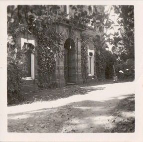
Photograph, Portico, D'Estaville, 7 Barry Street, 1050-1960
The Melbourne artist Alma Agnes Marion Figuerola, was the daughter of Juan Pedro Narciso Figuerola (1869-1919) and Alice Lucinda Walker Hanson (1889-1969). Each of their three daughters grew up to be involved in the arts: Alma as a painter; Carmen Irene (1906-1993) as a short story writer, poet and teacher of dancing; and Sylvia (also Silvia) Lyla Alice (1911-1992) as a composer and cellist. The first art lessons Alma Figuerola received were with Oscar Binder. Later she attended the art school established by the Melbourne 'tonalist' [Duncan] Max Meldrum (1875-1955). She graduated from his school in 1920, participating in her first group exhibition in the same year. Solo exhibitions of her work were to be held in 1933 at the Meldrum Gallery in Elizabeth Street, in 1937 and 1945 at the Athenaeum Gallery at 188 Collins Street, and in 1951 at Georges Gallery in Collins Street. Throughout her extensive career she participated in group exhibitions, usually with artists of the Meldrum School, and as a member of the Twenty Melbourne Painters, of which she was invited to become an associate in 1935. In 1953, her portrait of Professor ES Hills was entered in the Archibald Prize Competition of the Art Gallery of New South Wales. A resident of Kew from the 1930s - 51 Studley Park Road, often with her mother, her sister Carmen, or both - from c.1942 until her death she lived at 'D’Estaville', 7 Barry Street. From the late 1930s she is recorded as actively contributing to the arts at a local level. In 1939 and 1940 she participated in art exhibitions at the Hawthorn Municipal Library organised by Jessie Carbines. From 1944 to 1951 she co-organised successive Kew Arts Festivals, initially in the Presbyterian Church Hall in Highbury Grove and later at the Recreation Hall in Wellington Street. A foundation member of the Kew Historical Society in 1958, Alma Figuerola remained an active member of the Society until her death on 8 December 1970. She predeceased her two sisters who both died in the 1990s and who are buried at Andersons' Creek Cemetery in Warrandyte.View of the entrance to D'Estaville on the south side of the house. D'Estaville, built for Sir William Stawell, was the home of the Figuerola sisters from the 1940s to the 1990s. The photograph is from the Alma Figuerola photograph album. alma figuerola album, arists - kew (vic), artists - meldrum school, occupants - 7 barry street - kew (vic) -
 Surrey Hills Historical Society Collection
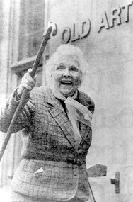
Photograph, Dr Edna Gault, 1988, 1988
Query: Originally from a newspaper article. Dr Gault enrolled in U3A research aged 84 years, after retiring from psychiatry. She joined a U3A current affairs class and thrived on the weekly tutorial and interaction with other students. Quote: “My tutor Don Graves suggested I do further research so I have been studying what makes Aboriginal women so strong in their community. I have been doing an interview once or twice a week and writing it up.” - extract from ‘The Sun’ by Amanda Place 23 August 1988. Dr Edna Gault and her husband Dr. Edward Woodfall Gault set up practice in Surrey Hills in 1931 and built their home at 693 Canterbury Road, on the corner of Florence Road in 1933. In 1937 they went to India as medical missionaries, taking over the missionary hospital at Azamgah, established by his sister Dr. Adelaide Gault, who had to return to Australia on account of ill-health. They finished up at Vellore, South India. Dr Gault was born Edna Isabel Baylis in 1904 in NSW; she married her husband in 1932 in Chatswood, NSW. Later homes were: 13 Kasouka Road, Camberwell (1949); Warrandyte (1963) and Ivanhoe (1980). There is a biography of her life entitled 'A very amazing life' by Bette McLaughlin, a copy of which is in this collection. A black and white photograph of a happy looking eldery lady raising her walking stick.(mrs) (dr) edna gault, doctors, surrey hills, canterbury road, florence road, 1933, (miss) (dr) adelaide gault, 1988, university of the third age, u3a, psychiatrists, missionaries, (mr) (dr) edward woodfall gault, (miss) edna isabel baylis, (mrs) (dr) edna isabel gault -
 National Wool Museum
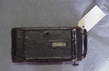
Camera
Kodak Model 1A Junior folding camera that uses size 116 film. Owned by donor's mother. Jess Cameron Shannon (nee Gilbert). This was my mother's camera and took many snaps of her family in Orbost, East Gippsland, moved with her to South Yarra as a young working woman in the 1930s, then on out to Warrandyte in 1951 with her young family.Kodak Model 1A Junior folding camera. Kodak Model 1A Junior folding camera.Kodakdepression era, kodak australia, shannon, ms gael - national wool museum -
 Federation University Art Collection
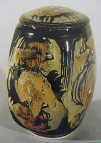
Ceramic, 'Covered Jar' by Reg Preston, 1983, c1983
Reg PRESTON (1917-2000) Born Bellevue Hill, Sydney, New South Wales Reg Preston studied sculpture at Westminster School of Art, London but was a self-taught ceramicist. His first solo exhibition was in Melbourne in 1958. He founded the Potters' Cottage, Warrandyte, Victoria in 1958, where he has taught part-time. During the 1960s Preston and his wife produced a line of pottery under the name “Ceres". He switched to stoneware in the mid 1960s and continued working well into the 1980s. Multiple glazed stoneware over tenmoku glaze. Maker's stamp covered by glaze. Preston painted in glaze.ceramics, reg preston, jan feder memorial ceramics collection, gippsland campus, functional ware -
Federation University Art Collection
Artwork - Ceramics, Ceramic Containers by Ailsa Adern, c1950
Ailsa ADERN (1918-2006) Born New Zealand Arrived Melbourne 1942 Elsa Ardern arrived in Melbourne in 1942 to earn money for a trip to the United Kingdon. After marrying she settled at Warrandyte. In 1954, after her two children started school, Adern studied Pottery at Melbourne Technical College under John Bernard Knight. In 1961 she joined the Potters' Cottage at Warrandyte with friends Sylvia Halpern and Kate Janeba. She worked from a studio under the family home, exhibiting at the cottage and also through the Victorian Ceramic Group when it was set up in 1969. In 1980 she established a workshop at Tathra on the far south coast of NSW, sharing her time between Tathra and Warrandyte for the next 25 years. Amongst the work made at Tathra were some very large pieces which she fired in the Stafford Brothers' wood-fired brick-kiln at Kalaru. Part of the clay for these came from the Staffords' clay-pits. With Sylvia Halpern and Gus McLaren Ailsa Asern celebrated her long association with the Potters' Cottage by exhibiting in its 45th anniversary exhibition in 2003. 2. Her works are signed with an incised 'Elsa Ardern' or 'EA'.Two thrown and handworked 'bottles' featuring verticle ridges on the edge of each form. Her pots are valued for their strong form , ed by her characteristically subtle wood-ash glazes. ceramics, ailsa adern, pottery -
Federation University Art Collection
Artwork - Ceramics, Ceramic Forms by Elsa Adern
Elsa ADERN (1918-2006) Born New Zealand Arrived Melbourne 1942 Elsa Ardern was living at Warrandyte in 1954 when she started studying pottery under John Bernard Knight at the Melbourne Technical College. In 1961 she was a founding member of Potters' Cottage at Warrandyte with friends Sylvia Halpern and Kate Janeba. She worked from a studio under the family home, exhibiting at the cottage and also through the Victorian Ceramic Group when it was set up in 1969. In 1980 she established a workshop at Tathra on the far south coast of NSW, sharing her time between Tathra and Warrandyte for the next 25 years. Amongst the work made at Tathra were some very large pieces which she fired in the Stafford Brothers' wood-fired brick-kiln at Kalaru. Part of the clay for these came from the Staffords' clay-pits. Elsa Adern is known for her strong form of her pots, enhanced by her characteristically subtle wood-ash glazes. Her works are signed with an incised 'Elsa Ardern' or 'EA'. (http://www.australianpotteryatbemboka.com.au/shop/index.php?manufacturers_id=32)available, elsa adern, available ceramics, ceramics -
 Ringwood and District Historical Society
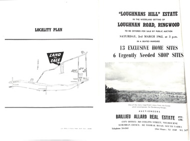
Document - Folder, Subdivision Auction - Loughnans Hill Estate 1962, Ringwood, Victoria
Double-sided bifold page advertising auction on Saturday 3rd March, 1962 - 13 residential allotments in Hearthside Court and 6 shop sites in Loughnan Road, with map of subdivision, terms of sale, and summary of features and services. Adjoining service station shown on accompanying Plan of Subdivision - Part of Crown Allotment 28 Parish of Warrandyte, also showing location of property known as "Hearth", hence Hearthside Court.Auctioneers - Baillieu Allard Real Estate Pty Ltd., 360 Collins Street, Melbourne, and 302 Toorak Road, South Yarra. Telephone 24-4365, After hours XU1549, WL2471. -
 Eltham District Historical Society Inc
Photograph - Digital Photograph, Marguerite Marshall, One Tree Hill Mine, Smiths Gully, 8 June 2006
Gold was discovered on One Tree Hill in 1854. The site has been worked intermittently until fairly recent times. Published: Nillumbik Now and Then / Marguerite Marshall 2008; photographs Alan King with Marguerite Marshall.; p53 Though still a working mine, One Tree Hill Mine at Smiths Gully, now stands in a tranquil reserve surrounded by bush and native animals - in contrast to its heyday. In the mid 19th century, when the mine was part of the Caledonia Goldfields, hundreds of men in search of their fortune worked the alluvial gold in the Yarra River, its tributaries and the reefs that made up the goldfields. Miner Stan Bone, assisted by Wilfred Haywood, is the last of the independent gold miners in the area and still uses the quartz crushing battery as miners did when gold was first discovered in the area in 1851.1 Stan, who is the last of six generations of miners in his family, was aged 17 when he began mining on his father Alex’ mine, The Golden Crown in Yarrambat. These days, after blasting the gold-bearing rock in Mystery Reef, one of the four reefs at One Tree Hill, Stan transports it around five kilometres by tip truck to the Black Cameron Mine for crushing. There he uses water from the waterlogged mine, (which still contains gold), as the Happy Valley Creek at One Tree Hill is usually dry.2 The One Tree Hill Mine has been worked for close to a century since it opened around the late 1850s.3 The Swedish Reef was its most productive reef and one of the largest in the area. Around 1859, extractions included 204 ounces (5.8kg) of gold, won from 57 pounds (26kg) of stone.4 Then during World War Two, Stan’s uncle, Bill Wallace, and Alex Bone, closed the mine. In 1973, Stan, with his Uncle Bill, reopened the Black Cameron Mine and worked there until 1988. Stan resumed mining One Tree Hill in 1998. As late as the 1920s gold was picked up by chance! When crossing a gully on his way to vote at the St Andrews Primary School, Bill Joyce picked up some quartz containing gold. This site was to become the Black Cameron Mine. The Caledonia Diggings, named after Scotland’s ancient name by local Scots, began around Market Square (now Smiths Gully) and included Queenstown (St Andrews), Kingstown (Panton Hill) and Diamond Creek. There were also poorer bearing fields in Kangaroo Ground and Swipers Gully (now Research). * None of these compared in riches to the Ballarat and Bendigo fields5, but the Caledonia Diggings continued intermittently for close to 100 years. Gold was discovered in Victoria following a bid to stem the disappearance of much needed workmen to the New South Wales diggings. Several businessmen offered a reward of £200, for the discovery of gold within 200 miles (322 km) of Melbourne. Late in June 1851, gold was first discovered at Andersons Creek, Warrandyte. Then in 1854, George Boston and two other men discovered gold at Smiths Gully. Gold transformed the quiet districts, with a constant flow of families and vehicles on the dirt tracks en route to the Caledonia Diggings. Three thousand people worked the gullies in Market Square, including about 1000 Chinese miners. The square established its own police, mining warden, gold battery, school, shops and cemetery and grog flowed. Market Square flourished until the middle 1860s. Bullocks transported quartz from the Caledonia Goldfields to the crushing machinery at the Queenstown/St Andrews Battery, near Smiths Gully Cemetery. It was destroyed by bushfire in 1962. By the late 1850s, most early alluvial fields were in decline, but minor rushes continued until around 1900 and some until the early 1940s. Some miners did well, although most earned little from their hard labour in the harsh and primitive conditions.6 But according to historian, Mick Woiwod, the gold fields helped to democratise society, as individuals from all walks of life were forced to share experiences, and the ability to succeed, depended less on inherited wealth or social rank.This collection of almost 130 photos about places and people within the Shire of Nillumbik, an urban and rural municipality in Melbourne's north, contributes to an understanding of the history of the Shire. Published in 2008 immediately prior to the Black Saturday bushfires of February 7, 2009, it documents sites that were impacted, and in some cases destroyed by the fires. It includes photographs taken especially for the publication, creating a unique time capsule representing the Shire in the early 21st century. It remains the most recent comprehenesive publication devoted to the Shire's history connecting local residents to the past. nillumbik now and then (marshall-king) collection, gold mining, one tree hill mine, smiths gully -
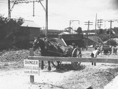 Ringwood and District Historical Society
Photograph, Construction of railway viaduct in Pitt Street, Ringwood - circa 1923, south side looking east
Black and White photograph (2 copies)Type below one copy: "Making Warrandyte Rd Subway, 1923 Taken from Pitt St." -
 Melbourne Tram Museum
Map, Melbourne & Metropolitan Tramways Board (MMTB), MMTB Route Maps, 1979
Series of colour maps for various tram and bus routes, dated 1979. Also contained, not scanned are letters, reports, and specifications for printing these maps for use in shelters etc. Some have the Transport Information Centre telephone printed on them. Some are finished with a plastic laminate finish on either one or both sides. Show the major cross streets, parks, schools, other tram routes, major stop numbers, and railway lines. See also item 3909 for another example of these. Trams 1 - City route guide - R9/77 - showing all route numbers and destinations that passed through the CBD. 2 - Bourke St tram routes - R4/77 - East Brunswick Blyth St and East Preston Tyler St and intermediate routes, routes 95, 96, 97, 90, 89 and 88. 3 - Malvern, East Malvern, Carnegie, and East Brighton Tram Routes (from St Kilda Junction) - R1/79 - shows routes 5, 3, 67, 66, 61, 62, and 64. 4 - Elizabeth St tram routes - R12/77 - Essendon Airport, West Maribyrnong, North Coburg lines, routes 50, 58, 60, 54, 57, 52. 49, 59, 18, 20 and 19 5 - Flinders St tram routes - R5/78 - North Balwyn, East Burwood, routes 48, 40, 41, Hartwell, 28, 74 and 75 6 - Kew - St Kilda Beach - R1/79 - Route 69. 7 - Mont - Albert City - R11/77, shows routes 43. 47. 45. 44 8 - St Kilda Rd Tram Routes R12/77 - details South Melbourne Beach, route 1 and route 2 and St Kilda Beach routes 15, 16, and 55 otherwise shows where the various routes branch off St Kilda Road 9 - Batman Ave tram routes - R9/77 - Wattle Park, North Richmond and Prahran - routes 70, 71, 78 and 79. 10 - Footscray - Moonee Ponds - R3/81 - Route 82 11 - Swanston St tram guide - R1/79 - lists all routes and route numbers that branch or cross Swanston St between Grattan St and St Kilda Junction. 12 - Toorak Camberwell and Glen Iris tram route with Camberwell Junction and Malvern Town Hall, R1/79, routes 8, 7, 6, 72, and 73 shown. 13 - West Preston - Beach tram routes - R12/77 - routes 10, 11, 9 and 12, 14 - William St tram routes - R12/77 - Route 55, 56, and 63 - South Melbourne Depot and Domain. Buses 1 - Footscray, Sunshine, Deer Park, Nth Altona & Fishermans Bend - R2/79 2 - Box Hill bus routes to Templestowe, Heidelberg & East Kew - R6/78 - notes superseded by R3/82 3 - Plan of Russell St Melbourne bus departure bays. 4 - Box Hill, Mitcham & Ringwood bus routes to East Doncaster & Warrandyte - R3/82 5 - City - Warrandyte & East Doncaster bus routes - R3/82 & R6/78 6 - Bulleen - City - Port Melbourne - Garden City Bus route - R6/78 7 - North Altona - City bus route - 11/78 8 - Clifton Hill - Elsternwick - R2/79 9 - La Trobe - Northland - West Heidelberg - City Bus Service via East Freeway - 11/79 and R3/81 10 - Box Hill, Mitcham & Ringwood Bus Routes to East Doncaster & Warrandyte - R10/84 - with the Metropolitan Transit logo.Yields information about tram and bus routes in late 1970s early 1980s.Book - brown comb binding, card and clear plastic covers containing both bound and unbound maps and documents.K C Painter on front cover in ink.tramways, mmtb, tram routes, maps, bus routes, route numbers, routes, route guide -
 Eltham District Historical Society Inc
Film - Video (VHS), Dynavision Video Production, 1994 Eltham Festival, 11 Nov 1994
... Club, Montmorency South Primary School, North Warrandyte Fire... Club, Montmorency South Primary School, North Warrandyte Fire ...20th Eltham Community Festival and last under the auspices of the Shire of Eltham. The Grand Parade focussing on the theme "Echoes of Eltham - Celebrating the visions of Eltrham from the past and into the future" was headed by Jock Read on his horse Lofty who had been filmed in an Anzac Day Parade on an earlier horse which had featured in the television show Matlock. The parade travelled north along Main Street to just past the Post Office then back south to Panther Place. Parade participants included 1st Eltham Brownies, 1st Eltham Venturers, 2nd Eltham Sea Scouts, 2nd Eltham Venturers, 3rd Eltham Brownies, Australian Democrats, Briar Hill Primary School, Circus Chaos, Country Fire Authority, Diamond Valley People for Disarmament, Diamond Valley Railway, Eltham Community Health Centre, Eltham District Horse and Pony Club, Eltham East Primary School, Eltham Fire Brigade, Eltham Junior Football Club (Panthers), Eltham Little Theatre, Eltham North Primary School, Eltham Playhouse Co-op, Eltham Pre-school, Eltham Roller Skating Club, Eltham South Pre-School Centre, Eltham Steam and Stationary Engine Society, Greenhills Neighbourhood House, Heidelberg Municipal Band, Hurstbridge Learning Co-op, Jocklebeary Farm, Kangaroo Ground Primary School, Learning Co-op Primary School, Lower Plenty Primary School, Main Road, Montmorency Gardening Club, Montmorency South Primary School, North Warrandyte Fire Brigade, Plenty Valley 88.6 FM, Research Pre-school, Research Primary School, Ron Sampson, Salvation Army Band (Briar Hill), Sherbourne Primary School, Shire of Eltham, State Emergency Service (Eltham) and Woodridge Pre-school. The parade commentary was provided by Plenty Valley FM 88.6 with guest commentator, Shire President Cr. John Graves. Following the parade is video footage from a helicopter of Alistair Knox Park, displays along Main Road and activities in Alistair Knox Park and the Rugby oval along with stationary engines, helicopter joyrides, Eltham People's Choir, music entertainment. Scenes also from the Diamond Valley Railway at Eltham Lower Park and finishing with the fireworks display. At the end of the video is a promotional video for Dynavision Video Production, a local video production company that produced the video and Diamond Photos (Kodak Express). One of the highlights of the festival was a tree planting ceremony in Alistair Knox Park to celebrate 123 years of the Shire of Eltham led by Shire President Cr. John Graves and representatives of the Wurrundjeri, traditional land owners of the area.VHS Video cassette (poor quality) Converted to MP4 file format 45:01, 535MB DVD copy of VHS cassette (better quality)1st eltham brownies, 1st eltham venturers, 2nd eltham sea scouts, 2nd eltham venturers, 3rd eltham brownies, 1994, aerial photographs, alistair knox park, arthur street, australian democrats, briar hill primary school, circus chaos, country fire authority, diamond valley people for disarmament, diamond valley railway, eltham community health centre, eltham district horse and pony club, eltham east primary school, eltham festival, eltham fire brigade, eltham junior football club (panthers), eltham little theatre, eltham lower park, eltham north primary school, eltham people's choir, eltham playhouse co-op, eltham pre-school, eltham roller skating club, eltham south pre-school centre, eltham steam and stationary engine society, grand parade, greenhills neighbourhood house, heidelberg municipal band, hurstbridge learning co-op, jock read, jocklebeary farm, john graves, kangaroo ground primary school, learning co-op primary school, lofty (horse), lower plenty primary school, main road, matlock police (tv show), montmorency gardening club, montmorency south primary school, nicholaus lauder estate, north warrandyte fire brigade, plenty valley 88.6 fm, research pre-school, research primary school, ron sampson, salvation army band (briar hill), sherbourne primary school, shire of eltham, state emergency service (eltham), video recording, woodridge pre-school -
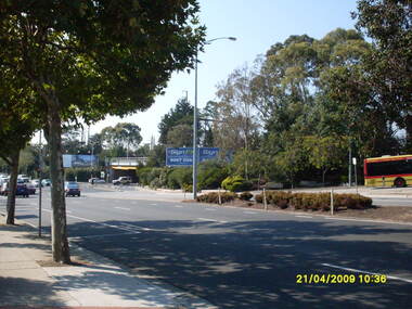 Ringwood and District Historical Society
Photograph, Looking across Maroondah Highway looking south-east to the Warrandyte Road railway underpass, on 21 April 2009
... Looking across Maroondah Highway looking south-east to the... Maroondah Highway looking south-east to the Warrandyte Road railway ...Ron Brons photographic study of Ringwood. -
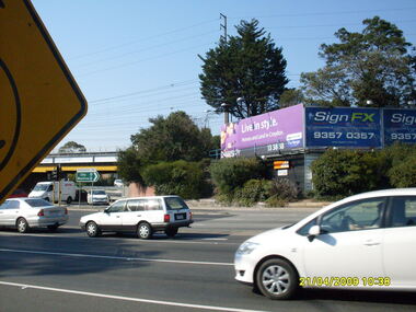 Ringwood and District Historical Society
Photograph, Looking south-east at Maroondah Highway and Warrandyte Road intersection, on 21 April 2009
Ron Brons photographic study of Ringwood.