Showing 250 items
matching water towers
-
 Buninyong & District Historical Society
Photograph - Original Colour Photo of Rokewood Water Service Basin, Enfield, Derek Leather, Rokewood Water Service Basin, 1986
Kryal Castle, front view, with castellated walls and twin towers. Photographed 1986An example of late 20 th Century tourist attraction. Still is use.Colour photo of the front view of Kryal Castle mt warrenheip, kryal castle -
 Buninyong & District Historical Society
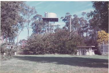
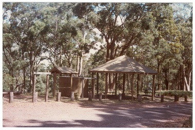
Photograph - Colour photograph, Colour photograph of Mt. Buninyong picnic area
... Water tower... Shire Council Mount Buninyong recreation Water tower C.C.P ...One of a series of photographs taken for Buninyong Shire Council 1980sMount Buninyong was reserved as a public park in 1866.Colour photograph of Mt Buninyong picnic areabuninyong shire council, mount buninyong, recreation, water tower, c.c.p. wilson -
 Tatura Irrigation & Wartime Camps Museum
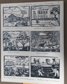
Drawing - Woodcuts, 1943
Camp 3. made by Gudrun and Isolde Frank, camp 3 c.Black and white sketches for calendar. 1943. 6 sketches. 1 - Cloudy sky, with hut and tree to the right and a truck front right; 2 - a guard tower on left hand side, 4 water tanks in Centre and a cloud to the right. front shows some rocks; 3 - Cloudy sky, 2 big trees (one on left and one on right), 3 bare trees in Centre. Across the front are 4 sheep and 4 four posts; 4 - 1 horse in foreground the 3 in back ground with trees in background; 5 - two children picking vegetables with a small hut to the right and a fence in front of 2 trees; 6 - 5 men working in a garden, 1 with wheelbarrow.the number 4 top right hand cornercamp 3, gudrun frank, isolde frank, frank zimmer, camp calendars, templers -
 Tatura Irrigation & Wartime Camps Museum
Photograph, 1918
Taken by photographer for State Rivers and Water Supply Commission.Medium sized black and white photograph. Sugarloaf Reservoir construction 22/2/1918 / Round concrete control tower and the spillway under construction / Traction engine and pump under timber cover middle foreground / Mount Sugarloaf in background.victorian state rivers and supply commission, sugarloaf reservoir -
Tatura Irrigation & Wartime Camps Museum
Photograph, 24/3/1917
Taken by photographer for State Rivers and Water Supply Commission.Medium sized black and white photograph. Sugarloaf Reservoir upper core wall, tower, tunnel, and lower dam under construction / Group of men left corner / Rocks in river bed foreground / Horse and cart off-centre left / Horse, cart, and men far right of centre / Words "Diversion Core Wall Tunnel and Riverbed" printed.victorian state rivers and supply commission, sugarloaf reservoir -
Tatura Irrigation & Wartime Camps Museum
Photograph, 24/3/1917
Taken by photographer for State Rivers and Water Supply Commission.Medium sized black and white photograph. Sugarloaf Reservoir construction of core wall and tower / Rail trucks on single line bottom centre / Traction engine and pump in timber shed lower right / Horses and carts on bank beside upper dams/ words printed:"Upper Dam Core Wall , Bed Rock, Lower Dam."victorian state rivers and supply commission, sugarloaf reservoir -
Tatura Irrigation & Wartime Camps Museum
Photograph, 1936/02
Photo taken by the photographer for Victoria State Rivers and Water Supply CommissionMedium sized black and white photograph. Eildon Reservoir spillway / Concrete structure centre / rock and earth fill dam wall top half / round concrete tower left midway along wall bank.goulburn, irrigation, photo, victoria state rivers and water supply commission, eildon, eildon weir -
Tatura Irrigation & Wartime Camps Museum
Photograph, 1936
... supporting floodgates / rectangular tower on right / Dam water beyond... supporting floodgates / rectangular tower on right / Dam water beyond ...Photo taken by the photographer for Victoria State Rivers and Water Supply CommissionMedium sized black and white photograph. Eildon Weir spillway / Concrete structure of terraced steps and pylons supporting floodgates / rectangular tower on right / Dam water beyond at top of picture.goulburn, irrigation, photo, victoria state rivers and water supply commission, eildon, eildon weir -
Tatura Irrigation & Wartime Camps Museum
Photograph, 1936
... concrete tower lower left / water above right / tree covered hill... concrete tower lower left / water above right / tree covered hill ...Photo taken by the photographer for Victoria State Rivers and Water Supply CommissionMedium sized black and white photograph. Eildon Reservoir dam wall / rock and earth fill wall from above / round concrete tower lower left / water above right / tree covered hill topgoulburn, irrigation, photo, victoria state rivers and water supply commission, eildon, eildon weir -
Tatura Irrigation & Wartime Camps Museum
Book, Sugar, Tears and Eyeties, 1994
Tells of the history of the Delseno family, being Italian in Australia, with the social life and customs of the time.THSoft, colourful cover depicting water colour painting of internees in a camp, with guard tower and surrounding countryside in the background. Book title is printed in colour Cover painted by Ivy Zappala of Bellenden Ker. The author Peter Dalenso has autographed each of the three copies with the date,1994 added. -
Tatura Irrigation & Wartime Camps Museum
Photograph, Leo Baker Collection, 2001
... old steel water tower... bartlett hilltop clubhouse old steel water tower criterion hotel ...Photographs taken by Leo Baker in 2001. Originals in his possession.leo baker collection, tatura buildings 2001, anglican church, catholic church, activity centre, swimming pool, clock tower, court house, senior citizens clubrooms, lake bartlett, hilltop clubhouse, old steel water tower, criterion hotel, bowling club, photograph, buildings -
Tatura Irrigation & Wartime Camps Museum
Video Tapes, Channels
Nine 20 minute video tapes "Channels" prepared by the Rural Water Commission from December 1992 to the end of the Rural Water Commission in June 1994.|Tape 1. Goulburn Murray Region.| Tape 2. New Tatura Office.| Tape 5. Yarrawonga Hydro project, Lake Makoan; Torrumbary Weir.|Tape 6. Ardmona Drain 11; Floods; Torrumbary Weir; Tatura Offices; Big Eildon Project.|Tape 7. Farm Dams.|Tape 8. Water Auction; Channel Ditching; Irrigation Ordering; Tatura Offices; Torrumbarry Weir; Sir Ronald East.|Tape 9. Torrumbary Weir; Mosquito Depression Drain; Eildon Tower Outlet; Farewell Message.9 video tapes prepared by the Rural Water Commission. -
 Torquay and District Historical Society
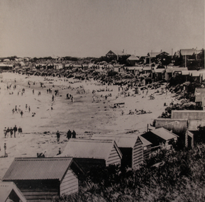
Photograph (copy), Early Torquay Beach Scenes
... . A water tower, long removed, is also visible in the background ...Photograph shows crowds of beachgoers on Torquay front beach in front of bathing boxes.The bathing boxes in the background were a feature of the Torquay foreshore until 1953. A water tower, long removed, is also visible in the background.Black and white photographtorquay victoria., bathing boxes, beach crowds early 1900s, beach wear -
 Rutherglen Historical Society
Image, Olive Codling
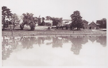
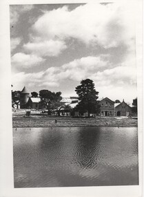
Some of the buildings of the Mount Ophir winery. Photo was taken by Miss Olive Codling, who was a life member of the Wodonga Historical Society. Photograph is believed to have been taken on the occasion of a Tour by the North East Branch, 1st combined meeting.Black and white photograph of a number of buildings, one of them with a tower, viewed across a body of water. This photograph is one of two printed on a single sheet of photographic paper.mt ophir, mount ophir, wine industry -
 Rutherglen Historical Society
Image, Olive Codling
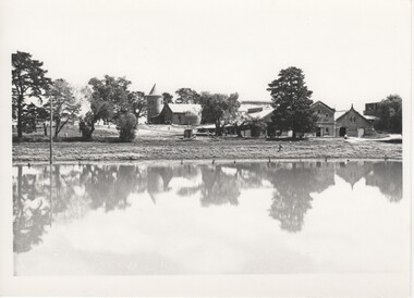
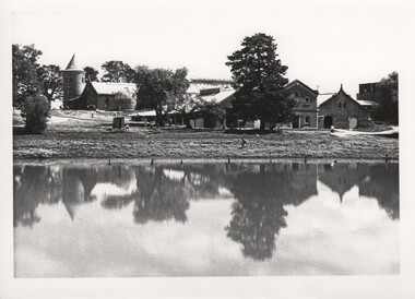
Some of the buildings of the Mount Ophir winery. Photo was taken by Miss Olive Codling, who was a life member of the Wodonga Historical Society. Photograph is believed to have been taken on the occasion of a Tour by the North East Branch, 1st combined meeting.Black and white photograph of a group of buildings, one with a tower, viewed across a body of water.mt ophir, mount ophir, wine industry -
 Rutherglen Historical Society
Image, Olive Codling
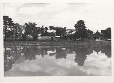
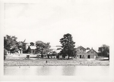
Some of the buildings of the Mount Ophir winery. Photo was taken by Miss Olive Codling, who was a life member of the Wodonga Historical Society. Photograph is believed to have been taken on the occasion of a Tour by the North East Branch, 1st combined meeting.Black and white photograph of a group of brick buildings, one of them with a tower, viewed across a body of water.mt ophir, mount ophir, wine industry -
 Rutherglen Historical Society
Image, Olive Codling
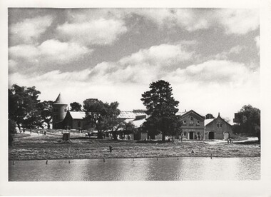
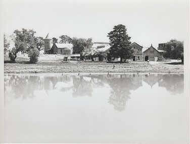
Some of the buildings of the Mount Ophir winery. Photo was taken by Miss Olive Codling, who was a life member of the Wodonga Historical Society. Photograph is believed to have been taken on the occasion of a Tour by the North East Branch, 1st combined meeting.Black and white photograph of a group of brick buildings, one of them with a tower, viewed across a body of water.mt ophir, mount ophir, wine industry -
 Rutherglen Historical Society
Image, Olive Codling
Some of the buildings of the Mount Ophir winery. Photo was taken by Miss Olive Codling, who was a life member of the Wodonga Historical Society. Photograph is believed to have been taken on the occasion of a Tour by the North East Branch, 1st combined meeting.Black and white photograph of a number of brick buildings, one of them with a tower, viewed across a body of water.mt ophir, mount ophir, wine industry -
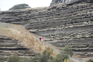 Ballarat Heritage Services
Photograph - Colour, Tower Hill, 2016, 31/12/2016
Tower Hill is a volcanic formation believed to have erupted about 32,000 years ago. Its formation is known as a "nested maar" and it is the largest example of its type in Victoria. During formation, molten lava pushed its way up through the Earth’s crust and encountered a layer of water-bearing rock. Violent explosions followed creating a shallow crater which later filled with water to form the lake. Further eruptions occurred in the centre of this crater, creating the islands and cone shaped hills. In 1892 Tower Hill became Victoria’s first National Park. In 1961, Tower Hill became a State Game Reserve under the then Fisheries and Wildlife Department and a major re-vegetation program began. (https://www.towerhill.org.au/index.php/about-reserve/history, accessed 23 December 2019)A number of photographs taken at Tower Hill, including the lakes, volcanic ash layer, and koala.tower hill, ash layer, volcano -
 Ballarat Heritage Services
Digital photograph, Lava Street Warrnambool - Fletcher Jones Ball, c2010-2017
... water tower... Office goldfields fletcher jones factory ball water tower Digital ...Digital Image of the Fletcher Jones Ball.fletcher jones, factory, ball, water tower -
 Ballarat Heritage Services
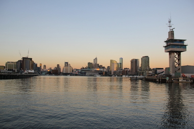
Digital photographs, L.J. Gervasoni, Yarra River Melbourne Docklands Port Control Tower, 2015
... dock docklands shipping port channel water container port ...Digital Imagesyarra river melbourne docklands, yarra river, dock, docklands, shipping, port, channel, water, container, port control tower, control tower, tower -
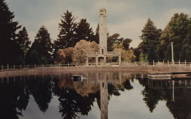 Ballarat Heritage Services
Photograph, Nucolorvue, Daylesford Pioneer Tower in Wombat Garrdens, 1957
... Victorian, known for its mineral water springs. Daylesford pioneer ...Daylesford is a tourist town in Central Victorian, known for its mineral water springs.Image of the Daylesford Pioneer Memorial Tower in Wombat Gardens, Daylesford.Daylesford, Victoria, Australia This famous holiday resort is famous for its up-to-date facilities, as well as for its natural attractions. The mineral Springs are renowned for their high medicinal elements. The visitor finds ample to amuse, in excellent fishing, boating, Boating, Swimming, golfing, hiking and riding. The district provides a wide range of typical Australian bush scenery, and the altitude of 2,000 feet above sea level as a tonic effect on all. Daylesford has modern hotels, guest houses, shops and places of amusement, also many other places of interest within short travelling distance. Bendigo, 50 miles, Ballara 30 miles, and Melbourne 75 miles, bring Daylesford within easy reach of many parts of Victoria. daylesford, pioneer tower, wombat gardens -
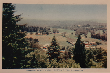 Ballarat Heritage Services
Photograph, Nucolorvue, Panorama from the Pioneed Memorial Tower, Daylesford, 1957
Daylesford is a tourist town in Central Victorian, known for its mineral water springs.Central Springs DaylesfordDaylesford, Victoria, Australia This famous holiday resort is famous for its up-to-date facilities, as well as for its natural attractions. The mineral Springs are renowned for their high medicinal elements. The visitor finds ample to amuse, in excellent fishing, boating, Boating, Swimming, golfing, hiking and riding. The district provides a wide range of typical Australian bush scenery, and the altitude of 2,000 feet above sea level as a tonic effect on all. Daylesford has modern hotels, guest houses, shops and places of amusement, also many other places of interest within short travelling distance. Bendigo, 50 miles, Ballara 30 miles, and Melbourne 75 miles, bring Daylesford within easy reach of many parts of Victoria. daylesford, wombat gardens, wombat hill gardens, daylesford pioneer memorial tower, landscape -
 Ballarat Heritage Services
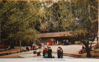
Souvenir - Postcard Booklet Image, Nucolor Vue, A Souvenir of Beautiful Daylesford, c1948
Daylesford in a tourist town with natural mineral water springsA booklet of colour images depicting 12 scenes of Daylesford, Victoria. The front cover is decorated with an illustration of a dirt road with sign post. Images include: Panorama over Daylesford, from lookout tower Panorama over Lake Daylesford Pioneer Memorial Lookout Tower, Daylesford Near the swimming pool, Lake Daylesford Botanical Gardens, Daylesford Vincent Street, showing Town Hall, Daylesford Vincent Street, Daylesford Glimpse of lovely Jubilee Lake, Daylesford Central Springs, Daylesford Sutton Springs, Daylesford Corner of the beautiful Botanical Gardens, Daylesford Loddon Falls, near Daylesford.daylesford, jubillee lake, wombat hill, vincent street, sutton springs, central springs, loddon springs, pioneer lookout, pioneer memorial lookout, loddon falls, lake daylesford -
 Ballarat Heritage Services
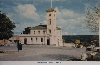
Souvenir - Image from a Postcard Booklet Image, Daylesford Post Office, c1948
Daylesford in a tourist town with natural mineral water springsPhotographic image of the Daylesford Post Office, which features a clock tower.daylesford, daylesford post office, central springs road, victoria street, vincent street -
 Ballarat Heritage Services
Photograph - Image, Tower Hill, Victoria, c1918, c1918
Tower Hill is a volcanic formation believed to have erupted about 32,000 years ago. Its formation is known as a "nested maar" and it is the largest example of its type in Victoria. During formation, molten lava pushed its way up through the Earth’s crust and encountered a layer of water-bearing rock. Violent explosions followed creating a shallow crater which later filled with water to form the lake. Further eruptions occurred in the centre of this crater, creating the islands and cone shaped hills. In 1892 Tower Hill became Victoria’s first National Park. In 1961, Tower Hill became a State Game Reserve under the then Fisheries and Wildlife Department and a major re-vegetation program began. (https://www.towerhill.org.au/index.php/about-reserve/history, accessed 23 December 2019)Black and white image of Tower Hill, near Koroit, Victoria.tower hill, volcano, crater -
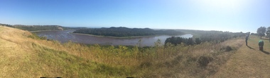 Ballarat Heritage Services
Photograph - Colour photograph, Tower Hill, 2016, 23/12/2015
Tower Hill is a volcanic formation believed to have erupted about 32,000 years ago. Its formation is known as a "nested maar" and it is the largest example of its type in Victoria. During formation, molten lava pushed its way up through the Earth’s crust and encountered a layer of water-bearing rock. Violent explosions followed creating a shallow crater which later filled with water to form the lake. Further eruptions occurred in the centre of this crater, creating the islands and cone shaped hills. In 1892 Tower Hill became Victoria’s first National Park. In 1961, Tower Hill became a State Game Reserve under the then Fisheries and Wildlife Department and a major re-vegetation program began. (https://www.towerhill.org.au/index.php/about-reserve/history, accessed 23 December 2019)Panaramic view of Tower Hill, Victoria.tower hill, volcano, crater