Showing 1123 items matching "waterways"
-
 Lakes Entrance Historical Society
Photograph, 1938
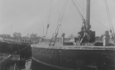
... Waterways ...Also two black and white copies 12.5 x 17.5 cm, second copy 10 x 15 cm.Black and white photograph showing remains of the S S JCD on extreme left, No. 9 engine powered stone barge centre and rebuilt Lady Harriet barge on right. Paynesville Victoria.ships and shipping, waterways -
 Lakes Entrance Historical Society
Photograph - Fish Pens, 1925 c
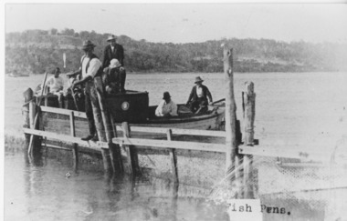
... Waterways ...Black and white photograph of group of people on a boat at fish pens, one man standing on the fence of fish pen. Jemmys Point and Kalimna in background. Lakes Entrance VictoriaFish Pensfishing industry, waterways -
 Lakes Entrance Historical Society
Photograph - Boggy Creek Gorge, 1999
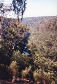
... Waterways ...Boggy Creek Gorge cuts through volcanics just before it meets salty water at Nowa Nowa Arm of Lake Tyers.Colour photograph from a vantage point of the distant Boggy Creek Gorge surrounded by steep tree and scrub covered ranges. Nowa Nowa Victoriavegetation, waterways -
 Lakes Entrance Historical Society
Photograph - JCD, 1920
... Waterways ...Also one other photograph enlargement 16 x 21.5Black and white photograph showing the SS JCD on the Mitchell River with crowd of excursionists onboard, buildings on bank in background, three people sitting on lifeboat on top deck. Bairnsdale Victoriaships and shipping, waterways -
 Lakes Entrance Historical Society
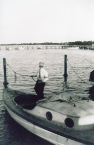
Photograph, Buckland, 1942 c
... Waterways ...Man in boat believed to be William BucklandBlack and white photograph of man standing in cockpit of small half cabin sailing type boat tied to mooring poles, jetty with other boats in background. Gippsland Lakes Victoriawaterways, boats and boating -
 Lakes Entrance Historical Society
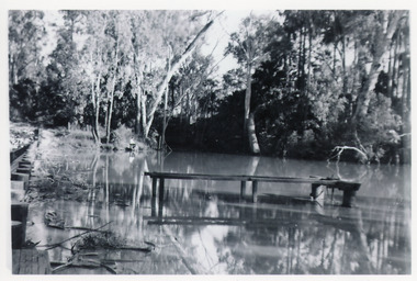
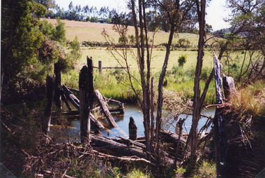
Photograph - Mississippi Creek Landing, 1950
... Waterways ...From 1910c to 1940c stone was bought from quarry by tramline to the entrance and other sites around the lakes for stabilisation works.Black and white photograph of a derelict landing at Mississippi Creek, North Arm, showing remains of piles without decking on bank, unattached jetty in water. Creek surrounded by trees. East Gippsland Victoriatransport, waterways -
 Lakes Entrance Historical Society
Book, Pitt M W and Synan T P, The Past Present and Future of the Gippsland Lakes, 1987
... Waterways ...Edited account of the papers presented at the Save the Gippsland Lakes Committees symposium on Lake Wellington and Lake Coleman held in Sale, November 1986. Includes history, geology, flora and fauna, and the many aspects of human impact on the region. Ilwaterways, government -
Lakes Entrance Historical Society
Photograph, 1900c
... Waterways ...This photograph has been archivedBlack and white photograph of the township, showing the township along Esplanade, Cunninghame Arm taken from the signal station at New Works. A very clear view of rear of Boole Poole School, later used as office, Pilot's residence and Harbour Engineer's residence, Carpenter's residence, and wooden boardwalk. Lakes Entrance Victoriawaterways, topography -
 Lakes Entrance Historical Society
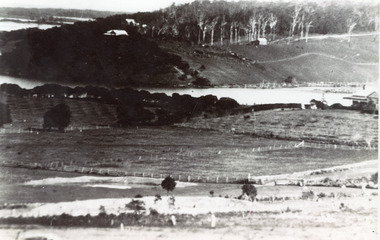
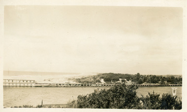
Photograph - Butcher's Paddock, 1935c
... Waterways ...Copied from postcard in possession of Mrs Vera BennettBlack and white photograph of cleared land on each side of the North Arm, showing white ring barked trees in front of dense bush on western side, cleared and fenced paddocks on eastern side. Lakes Entrance VictoriaPanorama scene at Seaview Tearooms - Lakes Entrancetownship, waterways -
 Lakes Entrance Historical Society
Photograph, 1920c
... Waterways ...Black and white photograph showing man made entrance from ocean to Gippsland Lakes, north end of western Pier on left, north end of Eastern Pier on right view looking from entrance towards Kalimna. Lakes Entrance Victoria waterways, piers -
 Lakes Entrance Historical Society
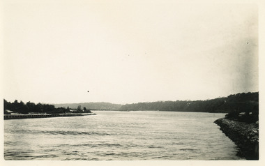
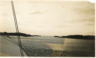
Photograph, 1920c
... Waterways ...Black and white photograph showing long range view of entrance, piers and dunes from a boat in the main channel, at Lakes Entrance, Victoria.waterways, topography -
 Lakes Entrance Historical Society
Photograph - Western Pier
... Waterways ...Also one black and white copy 9 x 15Sepia photograph showing wooden Western pier at entrance from ocean into the Gippsland Lakes, with dunes in background foreground shows top ridge of roof of rocket shed on left and shipwreck bell on far right foreground. Lakes Entrance Victoriawaterways, piers -
 Lakes Entrance Historical Society
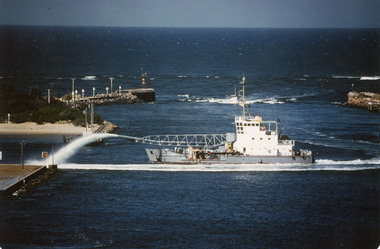
Photograph - April Hamer, Fraser, Ian, 1980 c
... Waterways ...Colour photograph of side casting sand dredge, April Hamer, working in the channel below Kalimna Hill inside the entrance from Bass Strait. Ocean in background, rock groynes of the entrance visible. Lakes Entrance Victoria waterways, dredging -
 Lakes Entrance Historical Society
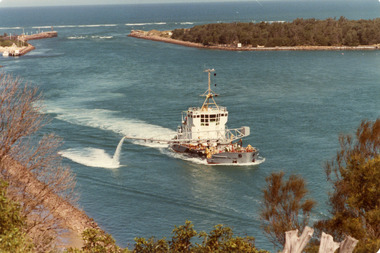
Photograph - April Hamer, Fraser, Ian, 1980 c
... Waterways ...Colour photograph of the sand dredge, April Hamer, working inside the entrance off Bullock Island. Ocean in background, rock groynes of the entrance visible, a fishing boat coming through the entrance. Lakes Entrance Victoriawaterways, dredging -
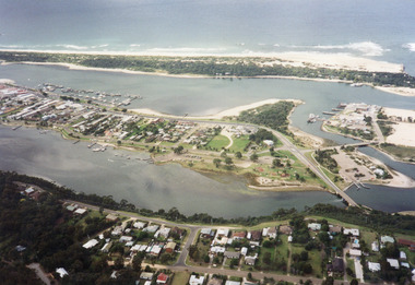 Lakes Entrance Historical Society
Photograph - Lakes Entrance, 1997c
... Waterways ...Colour print of aerial view looking south of western side of township. Shows housing on Kalimna Hill, North Arm, part of Bullock Island, Cunninghame Arm, the outer barrier and east pier of man made entrance. Lakes Entrance Victoriawaterways, township -
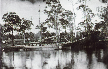 Lakes Entrance Historical Society
Photograph - Ethel BT, 1900c
... Waterways ...Captain ..Limschow, crew member A J legg and two others were rescuedBlack and white photograph showing schooner Ethel BT in Tambo River near Bennetts Brook. Sheds and buildings and post and rail fences on farm in background. Swan Reach Victoria boats and boating, waterways -
 Lakes Entrance Historical Society
Photograph - Lakes Entrance, 1945 c
... Waterways ...The Hulk of the Baang Yarnda on the North Arm foreshore. (Note in album)Black and white photograph showing view from Kalimna cliff overlooking North Arm and township, Cunninghame Arm and sand dunes out to Bass Strait. Hulk of old Baang Yarnda moored in North Arm, towed there in 1939 and left to rot. Thick vegetation in foreground. Lakes Entrance Victoria.township, waterways -
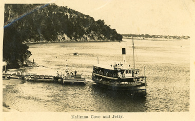 Lakes Entrance Historical Society
Postcard - Kalimna Jetty, 1925 c
... Waterways ...Second copy enlarged, black and white 16 x 25 cmBlack and white postcard showing S S Gippsland leaving Kalimna Jetty, Jemmys point in background, hummocks in distance, several people on jetty, small boat in distance, man on rocks fishing. Lakes Entrance VictoriaKalimna Cove and Jettyships and shipping, waterways -
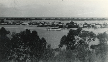
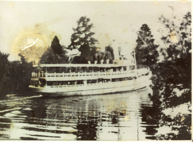 Lakes Entrance Historical Society
Photograph - S.S. Gippsland, 1910 c
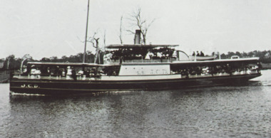
... Waterways ...Black and white photograph showing the S S Gippsland in Mitchell river, near Bairnsdale, shows three pine trees, other vegetation and a building on far bank, reflections in river,people on board, hull painted white, similar to a Bulmer postcard showing ship leaving Bairnsdale. Bairnsdale Victoria ships and shipping, waterways -
 Lakes Entrance Historical Society
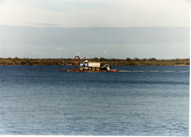
Photograph, 1994
... Waterways ...Also second identical copyColour photograph of a tiptruck being barged across Bancroft Bay from Metung to Boole Poole, Metung Victoriawaterways, transport -
 Lakes Entrance Historical Society
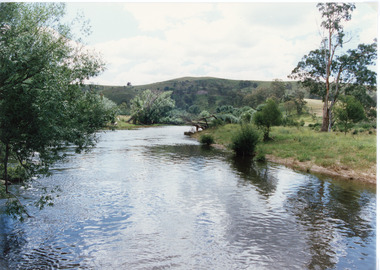
Photograph - Buchan River, Tambo Shire, 1994 c
... Waterways ...Colour photograph of the Buchan river, showing stream flowing between low banks, hills rising in distance. Buchan Victoria topography, waterways -
 Lakes Entrance Historical Society
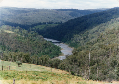
Photograph - Snowy River, Tambo Shire, 1994
... Waterways ...Also second identical copyColour photograph of the Snowy River near The Basin, showing a river flowing between rocky banks, densely forested hills rising on both sides and into the far distance. Buchan Victoria topography, waterways -
 Lakes Entrance Historical Society
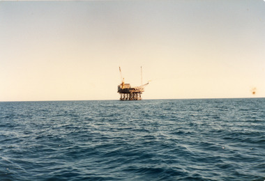
Photograph - Oil Rig, 2000 c
... Waterways ...Second photograph of a trade vessel at the oil rig.Colour photograph of an oil rig in Bass Strait. Port Albert Victoriawaterways, oil and gas industry -
 Lakes Entrance Historical Society
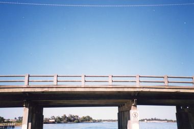
Photograph - North Arm Bridge, Holding M, 2000
... Waterways ...Also two other photographs similar views.|Also one showing old bridge onlyColour photograph showing the building of the new North Arm bridge, old North Arm bridge in background, taken from tourist ferry Mulloway, returning to jetty in North Arm. Lakes Entrance Victoriabridges, waterways -
 Lakes Entrance Historical Society
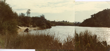
Photograph - Lake Bunga, Fish Marie, 1980
... Waterways ...Two photographs stitched together to show a panoramic view.Colour photograph showing view of Lake Bunga, near Lakes Entrance, looking upstream from near the entrance. Tramway bridge almost gone. Some piles remain. Vegetation on sides of lake, background hill cleared, seats along the shoreline, lake full and clean. Lake Bunga Victoriabridges, waterways -
 Lakes Entrance Historical Society
Photograph - Bridges, Fish Marie, 1965
... Waterways ...Also scanned photograph of a vehicle crossing the original bridgeBlack and white photograph showing the old Burnt Bridge over Toorloo Arm before being closed to vehicular traffic, near Lakes Entrance, Victoria,bridges, waterways -
 Lakes Entrance Historical Society
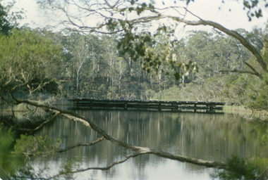
Photograph, 1998
... Waterways ...Colour photograph of the remains of a timber bridge on the former Princes Highway at Toorloo Arm Road, Lake Tyers, Victoriabridges, waterways -
 Lakes Entrance Historical Society
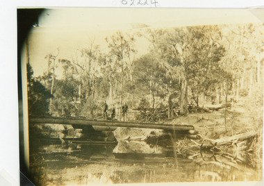
Photograph - Bridges, 1910
... Waterways ...Sepia photograph showing old bridge over Boggy Creek, presumably near Nowa Nowa. Two men and boy on bridge. Bridge supported by rough logs in centre and at ends. Gippsland Victoriabridges, waterways -
 Lakes Entrance Historical Society
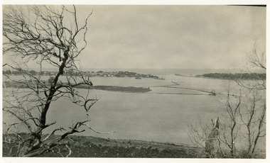
Photograph - The Entrance, 1925c
... Waterways ...Black and white photograph of Bullock Island, the entrance from Bass Strait to the Gippsland Lakes, the hummocks at the south shore of the lakes. Bathing boxes on Bullock Island. Lakes Entrance Victoriawaterways, islands -
 Lakes Entrance Historical Society
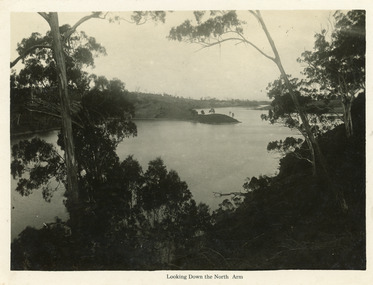
Postcard - North Arm, Bulmer H D, 1930c
... Waterways ...Black and white large format postcard of a broad reach of the North Arm, showing the calm waters of the lake, natural vegetation in foreground, some land bordering lake has been cleared. Lakes Entrance VictoriaLooking down the North Armwaterways, vegetation