Showing 4874 items
matching access
-
 Port Fairy Historical Society Museum and Archives
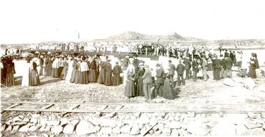
Photograph, Opening of bridge over South West Passage 1887, 1887
The opening of the bridge over the South West Passage would now allow the lighthouse keeper to walk between the island and the mainland carrying his produce and herding his cattle rather than loading a boat to transport everything. This would also allow the public access to the island for fishing. Black and White Photograph of Opening of bridge over South West Passage 1887events, civil, ceremony, griffith island, rail, bridge -
 Melbourne Tram Museum
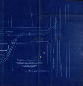
Drawing - PMTT, "Sketch shewing Location of track in Coldblo Street", 12/1908
The drawing shows a 3 road depot layout, with an access track from Glenferrie Road, referring to a letter and a point D on the drawing. Drawing dated 18-12-1908 is some 18 months before the PMTT opened with a 6 road depot and is possibly related to land acquisition. Yields information about PMTT depot planning in 1908.Blueprint of a drawing showing the track layout for the entry to Malvern Tram depot.tramcars, pmtt, malvern depot, trackwork -
 Orbost & District Historical Society
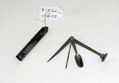
bistoury, First half 20th century
This veterinary equipment was found in an old walk-through dairy at Wombat Track. The instruments have been identified by Vet, Peter Honey,(9.1.2019) as instruments used to gain access to a teat cavity in a cow and to remove a blockage in the teat. They are possibly an improvised tool used c 1900-1950's.These items are representative of items used in Orbost on dairy farms in the first half of 20th century.A small set of instruments and container made of metal -possibly stainless steel. The instruments are a small spoon and two probes.On outside of container : D.C.L. SCOTCH WHISKYbistoury veterinary-equipment dairy farming -
 Orbost & District Historical Society
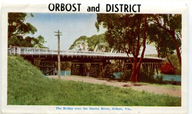
postcard series, 1960s
Included are photographs of the Orbost township, the Snowy River at Marlo, Gypsy Point, Buchan Caves and Bairnsdale. In the 1960s Orbost had a population of 4000 and was a major tourist attraction in Eastern Victoria with sufficient accommodation and facilities. It was the major town close to several national parks with access to either the surf or the snow. These postcards are pictorial records of Orbost in the 1960s. Postcards are very interesting records of places. architecture and transport.A colour postcard series with photographs of Orbost and the district. The cover photograph is of the Snowy River Bridge. There is an information card.Each photograph is labelled. at the bottom.postcards-orbost postcards-east-gippsland -
 Bialik College
Photograph (Item) - Junior School photographs. Students 5-7 years (approx) no date, class room and school ground activities
Junior School, colour photographs. Students appear to be 5-7 years (approx.). No names, no date. Images show students partaking in various class room and school ground activities. Students often appear eating as a group, or dressed up in costume. For inquiries or access contact [email protected], jewish school, bialik college, photographs -
Bialik College
Photograph (Item) - Bialik Excursions, post-1990s
Photographs are from various excursions that Bialik students attended. They range from upper school students in urban environments to primary school in regional spaces. Children are seen getting on and off buses, lined up as a group and in the Channel 9 tech spaces. For inquiries or access contact [email protected] photographs have brief inscriptions on the reverse, excursion, channel 9. Digital stamp on one image 8 November 1993school, jewish school, bialik college, photographs, excursion -
Bialik College
Textile - Bialik College Banner, c. 1960s, c. 1960s
School banner made c. 1960s out of blue felt material. Features decorative boarder, hanging tassels at the bottom and Bialik College logo in yellow and white paint. It was often used at events and features in photographs of school events. Please contact [email protected] to request access to this record.object -
Bialik College
Photograph (item) - Opening of the Besen Family Art and Technology Centre, 2001
Photographs of the opening of the Besen Family Art and Technology Centre, October 2001. Featuring Jack Gringlas, Gaby Levy (Israeli Ambassador), Genia Janover, Simon Crean (Minister of Education), Genia Janover, Marc Besen, Jeffrey Mahemoff. Please contact [email protected] to request access to this record.2000s, major events -
 Bialik College
Photograph (item) - Photographs donated by past student and staff member Rochelle Obel, 1970s
Photographs donated by past student and staff member Rochelle Obel, c. 1970s. Includes her first day of prep in 1972, Grade 1 1973, Speech Night at Kew Civic Centre, Principal Mieri at Shakespeare Grove. Please contact [email protected] to request access to this record. -
 Bialik College
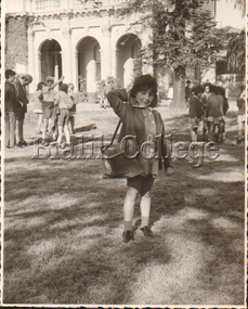
Exhibition Panel, 70th Anniversary: Beginnings, 2012
Panel from the exhibition held to celebrate the College's 70th anniversary in 2012. Photograph 1: Principal Moshe Meretz and visitor with Year 4 taken in 1966. Photograph 2: Bialik College Primary School students taken in 1963. Please contact [email protected] to request access to this record.history, 2000s -
 Bialik College
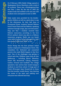
Exhibition Panel, 70th Anniversary: Bursting at the Seams, 2012
Panel from the exhibition held to celebrate the College's 70th anniversary in 2012. Photograph 1: Students with Bialik College banner, c. 1960s. Photograph 2: Prep class, 1968. Photograph 3: Year 6 class, 1969. Please contact [email protected] to request access to this record.shakespeare grove, bialik council, history, 2000s -
 Bialik College
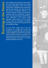
Exhibition Panel, '70th Anniversary Exhibition Documentation: Improving Facilities', 41063
Panel from the exhibition held to celebrate the College's 70th anniversary in 2012. Photograph One: A photograph of Bilaik Students at Auburn Road taken c.1980s.Photograph Two: A photograph of students at Bilaik College Sports Day during the 1980s. Please contact [email protected] to request access to this record.early learning centre, auburn road, hawthorn east campus, shakespeare grove, history, 2000s -
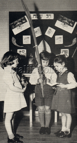 Bialik College
Photograph (item) - Students celebrating Succot at Shakespeare Grove, c. 1963-1964, c. 1963-1964
Students celebrating Succot at Shakespeare Grove, c. 1963-1964. Girl on left appears to be holding an etrog, and the boy in the centre appears to be holding a lulav. The girl on the right appears to be holding a prayer book (Siddur) and may be reciting a prayer. Please contact [email protected] to request access to this record.1960s, judaism -
 Bialik College
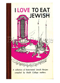
Book, I Love to Eat Jewish, 1968
non-fiction1960s, 1970s, 2010s, cookbook -
Bialik College
Mixed media (Sub-series) - Marketing and Promotion, 1970s-2000
1980s, 1990s, 2000s1980s, 1990s, 2000s -
 Vision Australia
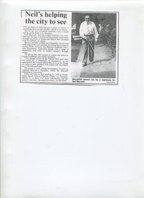
Article - Text, Neil's helping the city to see newspaper article
Summary update of Centenary AppealNewspaper article about Neil Maxwell and his involvement with Malvern's Disability Access and Information Services (DIAS). The work of the group, which includes approaching the council about the change rooms at Harold Holt pool and need to upgrade Malvern footpaths, and details on when the first meeting will be held for 1995.1 newspaper article cut from a newspapernon-fictionelizabeth maxwell, neil maxwell, stonnington council, advocacy -
 The Beechworth Burke Museum Research Collection
Card (Series) - Index Card, George Tibbits, Pritchard Lane or Gorge Road, Beechworth, 1976
George Tibbits, University of Melbourne. Faculty of Architecture, Building and Town & Regional PlanningIndex system that support the research for Beechworth : historical reconstruction / [by] George Tibbits ... [et al]Arranged by street names of BeechworthEach index card includes: street name and number of property, image of property, allotment and section number, property owners and dates of ownership, description of the property according to rate records, property floor plan with dimensions.beechworth, george tibbitsbeechworth, george tibbits -
 Glen Eira Historical Society
Photograph - NETTALIE
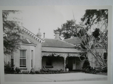
Various documents about and photographs of Nettalie or Netley House or The Nest on Balaclava Road Caulfield now part of Melbourne Grammar School: 1/The first is an article undated and unattributed accessed from Beresford.org on 14/07/2006 detailing with bibliography the history of Netley House including the owners especially the Shaw family. 2/There are several separately colour-printed photographs of the front facade of Nettalie most undated and unattributed, and one family portrait of the Shaw family circa 1863. All were also accessed from Beresford.org on 14/07/2006. 3/One black and white photograph is inscribed '73 Balaclava Rd Caulfield 3/9/72 Neg 16A'. 4/Two copies of a plan of Nettalie next to The Curragh and Harleston, also in the article and likely accessed from same source on same date. 5/A copy of Dr Cameron’s letter to Herbert Shaw dated 24/05/1949. 6/One copy of a letter from Herbert Shaw to Dr William Cameron dated 25/05/1949. 7/A plan of Melbourne Grammar School with each building dated to when it was built including Netley House in 1863.shaw herbert, shaw alfred henry, shaw arthur, shaw amelia, shaw lavinia, forsyth william, blundell mary, fosbery john, bakewell john, hailes george b, blundell miss, stephen george sir, billings richard, ware martha, desailly alfred, cameron william dr, cameron j mrs, nettalie, the nest, netley house, house names, caulfield north, balaclava road, grimwade house, orrong road, harleston, caulfield road district, st kilda east, the curragh, shelford, helenslea, sylliot hall, labassa, o’loughlin street, ormond, hotham street, melbourne grammar school, caulfield conservation study, mansions, teachers, schools, independent schools, hardware stores, business people, lawyers, businesses, brick houses, outbuildings, architectural styles, classrooms, bunya bunya pine trees, trees, orchards, land subdivisions, land sales, doctors -
Greensborough Historical Society
Newsletter, Greenhills and North Greensborough Progress Association, Community News: official journal of the Greenhills and Nth. Greensborough Progress Association. 26th March, 1973. Edition No. 2/73, 26/03/1973
This edition includes a report on the Progress Association's March 1973 meeting, President's report, 1973, What a way to run a railway, History Group visits the Greenhills area, Interview with ex-Councillor, Laurie Svendsen, Montmorency Baseball Club, Access to Plenty increased, School and Kinder news, Letter to the Editor.Newsletter, 28 p., illus.greenhills and north greensborough progress association, greenhills -
 Federation University Historical Collection
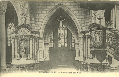
Postcard - Black and White, Reninghelst. c1917, c1917
Holmes Family WW1 memorabilia. Reningelst is a rural village in the Belgian province of West-Flanders, and a "deelgemeente" of the municipality Poperinge. A double railway was constructed during the First World War. Reningelst was a stopover for many soldiers on their way to or from the front. (http://en.wikipedia.org/wiki/Reningelst, accessed 11/07/2014)Black and White postcard showing the interior of a church in Reninghelst, Belgium, during World War Onepoperinghe, poperinge, flanders, chatham-holmes family collection, ww1, postcard -
 St Kilda Historical Society
Photograph - Photo map, 28/01/1951
One of a series of photo-maps produced for the Department of Crown Lands and Survey (1857-1983). For correlation with a current map, and access to other historical photo maps of Victoria, see the Historic Photo-Maps Index published by the Department of Environment, Land, Water and Planning at https://services.land.vic.gov.au/DELWPmaps/historical-photomaps/Black and white aerial photograph1424-45 SECRET 534 Run 18 Lens 12" Melbourne Metropolitan 12150 28.1.51 M639albert park, st kilda junction, st kilda pier, catani gardens, st kilda, prahran, albert park lake, 1951, middle park, st kilda beach, windsor -
 St Kilda Historical Society
Photograph - Photo map, 17/01/1951
One of a series of photo-maps produced for the Department of Crown Lands and Survey (1857-1983). For correlation with a current map, and access to other historical photo maps of Victoria, see the Historic Photo-Maps Index published by the Department of Environment, Land, Water and Planning at https://services.land.vic.gov.au/DELWPmaps/historical-photomaps/Black and white aerial photograph1414-21 538 Run 19 Lens 12" Melbourne Metropolitan 12150 17.1.51 M586st kilda, st kilda botanical gardens, peanut farm, elwood, 1951, point ormond, elwood canal, st kilda beach -
 St Kilda Historical Society
Photograph - Photo map, 28/01/1951
One of a series of photo-maps produced for the Department of Crown Lands and Survey (1857-1983). For correlation with a current map, and access to other historical photo maps of Victoria, see the Historic Photo-Maps Index published by the Department of Environment, Land, Water and Planning at https://services.land.vic.gov.au/DELWPmaps/historical-photomaps/Black and white aerial photograph1424-118 534 Run 20 Lens 12" Melbourne Metropolitan 12150 18.1.51M639elwood, point ormond, elwood park, elsternwick park, elwood beach, 1951 -
 St Kilda Historical Society
Photograph - Photo map, 17/01/1951
One of a series of photo-maps produced for the Department of Crown Lands and Survey (1857-1983). For correlation with a current map, and access to other historical photo maps of Victoria, see the Historic Photo-Maps Index published by the Department of Environment, Land, Water and Planning at https://services.land.vic.gov.au/DELWPmaps/historical-photomaps/Black and white aerial photograph1414-20 538 Run 19 Lens 12" Melbourne Metropolitan 12150 17.1.51 M586elwood, elsternwick, st kilda east, balaclava, ripponlea, 1951 -
 St Kilda Historical Society
Photograph - Photo map, 28/01/1951
One of a series of photo-maps produced for the Department of Crown Lands and Survey (1857-1983). For correlation with a current map, and access to other historical photo maps of Victoria, see the Historic Photo-Maps Index published by the Department of Environment, Land, Water and Planning at https://services.land.vic.gov.au/DELWPmaps/historical-photomaps/Black and white aerial photograph1424-44 534 Run 18 Lens 12" Melbourne Metropolitan 12150 28.1.51 M639 -
 St Kilda Historical Society
Photograph - Photo map, 28/01/1951
One of a series of photo-maps produced for the Department of Crown Lands and Survey (1857-1983). For correlation with a current map, and access to other historical photo maps of Victoria, see the Historic Photo-Maps Index published by the Department of Environment, Land, Water and Planning at https://services.land.vic.gov.au/DELWPmaps/historical-photomaps/Black and white aerial photograph1424-43 534 Run 18 Lens 12" Melbourne Metropolitan 12150 28.1.51 M639armadale, malvern, st kilda cemetery, caulfield north, st kilda east, 1951 -
 St Kilda Historical Society
Photograph - Photo map, 30/01/1960
One of a series of photo-maps produced for the Department of Crown Lands and Survey (1857-1983). For correlation with a current map, and access to other historical photo maps of Victoria, see the Historic Photo-Maps Index published by the Department of Environment, Land, Water and Planning at https://services.land.vic.gov.au/DELWPmaps/historical-photomaps/Black and white aerial photographVic 1093-62 Melbourne & Metropolitan Project Run 21 30.1.60 Lens 10" 8.200middle park, albert park, catani gardens, st kilda west, 1960 -
 St Kilda Historical Society
Photograph - Photo map, 30/01/1960
One of a series of photo-maps produced for the Department of Crown Lands and Survey (1857-1983). For correlation with a current map, and access to other historical photo maps of Victoria, see the Historic Photo-Maps Index published by the Department of Environment, Land, Water and Planning at https://services.land.vic.gov.au/DELWPmaps/historical-photomaps/Black and white aerial photographVic 1093-60 Melbourne & Metropolitan Project Run 21 30.1.60 Lens 10" 8.200st kilda, albert park, prahran, windsor, south yarra, 1960 -
 St Kilda Historical Society
Photograph - Photo map, 30/01/1960
One of a series of photo-maps produced for the Department of Crown Lands and Survey (1857-1983). For correlation with a current map, and access to other historical photo maps of Victoria, see the Historic Photo-Maps Index published by the Department of Environment, Land, Water and Planning at https://services.land.vic.gov.au/DELWPmaps/historical-photomaps/Black and white aerial photographVic 1092-36 Melbourne & Metropolitan Project Run 22 30.1.60 Lens 10" 8.200st kilda, st kilda pier, st kilda beach, catani gardens, 1960 -
 St Kilda Historical Society
Photograph - Photo map, 30/01/1960
One of a series of photo-maps produced for the Department of Crown Lands and Survey (1857-1983). For correlation with a current map, and access to other historical photo maps of Victoria, see the Historic Photo-Maps Index published by the Department of Environment, Land, Water and Planning at https://services.land.vic.gov.au/DELWPmaps/historical-photomaps/Black and white aerial photographVic 1092-38 Melbourne & Metropolitan Project Run 22 30.1.60 Lens 10" 8.200st kilda, st kilda beach, st kilda pier, catani gardens, 1960, st kilda botanical gardens, peanut farm