Showing 10936 items
matching lake.
-
 Lakes Entrance Regional Historical Society (operating as Lakes Entrance History Centre & Museum)
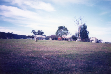
Photograph, Bennett, Vera, 1991
Date made May 1991|Old building demolished c2008. Ostler family arrived at Cunninghame (Lakes Entrance) by boat, walked to the site with their belongings, cleared the land, built a dwelling, farmed dairy herd, grew maize, had beehives.| Also one colour photograph of new dwelling constructed next to the old dwelling taken 29th September 2007|Also two other colour photographs old dwelling.Colour photograph of Ostlers old home, 106 Ostlers Road, showing a timber and corrugated iron structure amongst farm buildings and trees. Lakes Entrance Victoriahouses -
 Tramway Heritage Centre
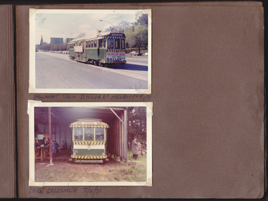
Photograph Album (part of), Ray Pearson's Photo Album - Trams of Victorian Railways, Ballarat, Bendigo, Geelong
Page 5 of Ray Pearson's Photo Album. Brown card page with two photographs (landscape format) placed on page using clear plastic photo corners. Both photographs depict trams, one in Melbourne (top), one at Lake Goldsmith, Victoria (bottom). Hand written inscriptions appear benetah each photo.Hand written inscription in biro under photographs. Top: BALLARAT TRAM St-KILDA RD MELBOURNE 1971 Bottom: LAKE GOLDSMITH 7/11/71 ballarat trams, ballarat tramways, vintage trams, lake goldsmith -
 Lakes Entrance Regional Historical Society (operating as Lakes Entrance History Centre & Museum)
Photograph, 2000
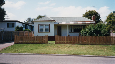
Part of a larger dwelling originally situated 607 Esplanade, (now site of Golden Beach Motel), other half moved to Lake Tyers Beach Road. This section moved to present site around 1965 by Ray Curry. Various residents Misses Phillips (original site) George Ward, R A and K D Bills from 1993.Colour photograph of a weatherboard dwelling with hip roof situated at 15 Coates Road. Has a bull nose veranda across front entry, oiled timber picket fence. Lakes Entrance Victoriahouses, fences, heritage study -
 The Beechworth Burke Museum
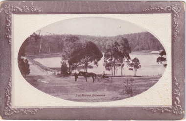
Postcard
Black and white photograph depicts wide shot of Lake Kerford, where an older man stands with a horse and small carriage. On top of the carriage sits a small child, and both face towards the camera to pose. Photograph does not state when it was captured, but possibly been taken c. 1920.The postcard holds Historic significance due to its connection to Beechworth and its Lake Kerford. It demonstrates the interactions between nature and current European residents, especially how the lake has somewhat been 'protected' with the man made fencing and road. It also presents information on the environmental development or degradation for the area, with possible changes to the environment that may have been caused by human physical forces, natural decay or Global Warming. The social significance is due to the connection between the postcard and the individuals in the photograph.Black and white oval photograph on rectangular postcard, printed on card.Obverse: Lake Kerford / Beechworth Reverse: POST CARD / Stamp Here / Printed in Australia / This space may be used for Correspondence within the Commonwealth without extra postage / THIS SPACE IS FOR NAME AND ADDRESS / 84 - 108 - 1 / BMM3000lakes, lake kerford, beechworth, postcard, horse drawn carriage -
 Ringwood and District Historical Society
Photograph, Ringwood black and white photographs
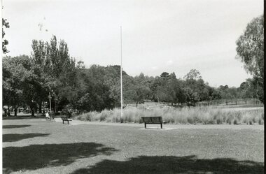
Black and white photographRingwood Lake viewed from North -
 Ringwood and District Historical Society
Photograph, Ringwood black and white photographs
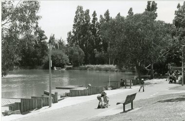
Black and white photographRingwood Lake viewed from East -
 National Wool Museum
Pennant
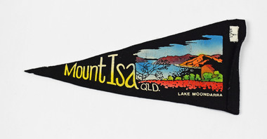
Mount Isa QLD. LAKE MOONDARRAmildura, victoria -
 National Wool Museum
Jumper, Roll neck sweater
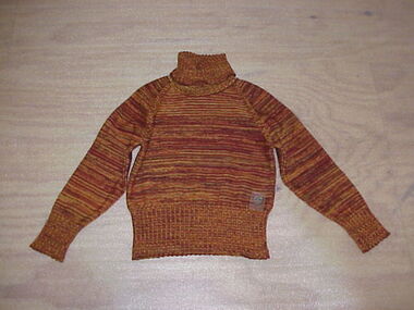
Part of the Winter Olympic Uniform, 2002 and worn by both sexes.Salt Lake City 2002 WOOLMARKfashion, costume, sport, salt lake city -
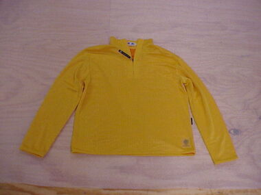 National Wool Museum
Sport shirt, Sportwool yellow top
Part of the casual Winter Olympic uniform, 2002 as worn by both sexes. (This item is sized 'L' most likely worn by a man.)WOOLMARK WOOLMARK SALT LAKE 2002fashion, sportwool, costume, sport, salt lake city -
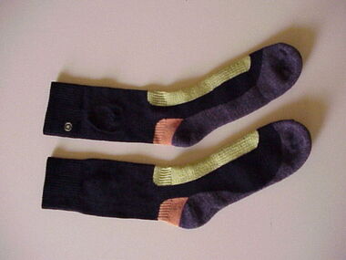 National Wool Museum
Socks, Mens hiking socks
Hiking socks to be worn with hiking boots for opening ceremony of Winter Olympics, 2002Australia Salt Lake City 2002fashion, costume, shoes, wool, sport, salt lake city -
 Kiewa Valley Historical Society
Photo - Bogong Village Township
In 1940 Field Headquarters for the Kiewa Scheme were established at Bogong with office, workshop facilities and accommodation for workmen, staff and some families constructed. (There had been a 'tent camp' on this site in 1939 but was destroyed by bushfires) Construction of accommodation continued until 1947. A total of 40 houses plus a hostel for single staff, post office, police station, medical centre and primary school all with water and sewerage and electricity supply. The staff hostel was known as Kiewa House and is now occupied by the Education Department. Lake Guy was named after Mr. L.T. Guy who was the Resident Engineer in charge of construction work and associated activities on the Kiewa area. He held this position from 1939 to November 1946 when he was transferred to Head Office. The Bogong Township was developed firstly as an accommodation centre (base camp) for construction workers employed under the Kiewa Hydroelectric Scheme. Due to the influx of European workers into the Township the beautification of the immediate surrounds (gardens etc.) had a distinct European flavour. This environment has been very beneficial for tourism in later years. At the completion of the scheme, in the 1960's, the village was opened to public/tourism use. Strict environmental control has not allowed for any extensive redevelopment in tourist accommodation and basically restricted it to the accommodation initially built for the construction workers. Activities such a bike riding, snow skiing, restricted horse riding and bush walking on the Alpine plains and mountains are now a viable part of the Kiewa Valley Tourist Industry. The lake is one of the many water storage reservoirs used to supply the power stations their main power to run the huge turbines generating the final product, electricityBlack and white photograph of Bogong Village from across Lake Guy. Photo mounted on buff cardbogong village, secv -
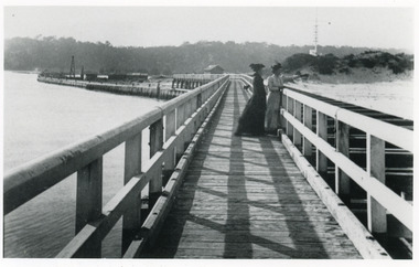 Lakes Entrance Regional Historical Society (operating as Lakes Entrance History Centre & Museum)
Photograph, Caire Nicholas John, 1905c
2 copies with inscription below|1 x 9 x 14|1 x 12.5 x 17.5|View of Flagstaff and Rocket Shed from the Eastern Pier of Lakes Entrance, this was the New Works, (photograph 1906c - A Maclachlan)|Enlargement black and white 20.5 x 28|Also copy in Caire P01049Black and white photograph showing two ladies on Eastern Pier, view of beach, dune and flagstaff on right, entrance and northern end of pier and works buildings on left, Kalimna escarpment in background. Lakes Entrance Victoriajetties, boats and boating, waterways -
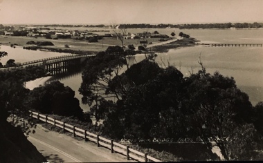 Kew Historical Society Inc
Photograph - North Arm Bridge, Lakes Entrance, Henry Beater Christian, 1920s
Henry Christian (c.1809-91) was one of the first settlers in Kew. He arrived in Victoria with his wife Agnes and son Orlando in 1855 on the Gypsy Queen. He established a rope-making business in Bulleen Road by 1858 but was declared insolvent two years later. In his final years, he was celebrated as one of the oldest living settlers of the district. His son, Orlando Henry Beater Christian (c.1853-1930) became a member of the Hawthorn Band and a foundation member of the Willsmere Swimming Club. Orlando and his wife Elizabeth had four children: Henry Beater (1886-1962), Ada Susannah May (1888-1962), Orlando Julius (1891-1917) and Lilian Adelaide ( -1956). Ada was to marry into the Washfold family. An item from an outstanding and diverse photographic collection, assembled by members of the Christian and Washfold families of Kew, comprising professional and amateur photography, depicting individuals, natural and settled environments and the interactions between these worlds. Photograph of Lake Arm Bridge at Lakes Entrance.Sent to Mavis and the boys [detailed text]landscape photography, lakes entrance (vic.), christian-washfold collection -
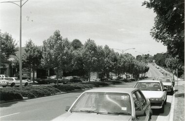
 City of Kingston
Photograph - Colour, c. 1993
Patterson Lakes is a suburb in the City of Kingston that is built one kilometre upstream of the mouth of the Patterson River. The area is bordered by the Patterson River and Eel Race Drain which enters the Kananook Creek. The suburb consists predominantly of newer housing developments and the tidal canal system of the development joins Port Phillip Bay.Patterson Lakes and the Kananook Creek were previously part of the extensive Carrum Carrum Swamp. The area was once a source of fish and eels for the Mayone-Bulluk clan of the Bunurong people. Over time the area was drained and in 1973 investigations commenced into the development of a unique residential area that would be built adjacent to canals and waterways. It was originally proposed to be known as "Gladesville". The development would give the suburb's homeowners access to Port Phillip Bay "from their back door". Circa 1974, the area was rezoned from rural to residential and named Patterson Lakes. Development has been continuous since the 1970s with construction of residential housing, schools, shopping centres, marinas, a hotel and library.Laminated colour aerial photograph of the Carrum and Patterson Lakes region within City of Kingston. This 1993 image includes Patterson River Secondary College, Roy Dore Reserve, Kananook Creek and Nepean Highway. The railway line can be seen as it veers inland from Eel Race Road, Seaford. The section of Palm Beach Drive, Curlew Point Drive, Snapper Point Drive, Clipper Island and Myola Street in Patterson Lakes appears to be a recent development with many spare blocks and new houses under construction.patterson lakes, seaford, kananook creek, carrum carrum swamp, canals and waterways -
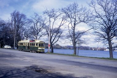 Ballarat Tramway Museum
Slide - 35mm slide/s - set of 3, Peter Moses, Aug. 1971
Set of three photos of SEC Ballarat tram No. 42 and a horse drawn milk cart in Wendouree Parade. All photos have Lake Wendouree in the background. .1 - Tram No. 42 at the Martin Ave. stop in Wendouree Parade. Tram has a SEC Briquette roof advertisement. .2 - Looking along Wendouree Parade towards Forest St and the SEC Depot area, shows tram 42 and the horse drawn milk wagon in the distance. .3 - Close up of the horse drawn milk wagon -Modern Dairy, with the delivery man or milk man stepping from the wagon. Kodak cardboard mount slide, taken by Peter Moses August 1971.On back of slides: .1 -"N42 Ballarat / Wendouree Pde & Lake" and "P. Moses" in black ink. .2 - "N42 Ballarat / Wendouree Pde & Lake" in red ink and "P. Moses" in black ink. .3 - "Ballarat / Horse Milk Van" in red ink.tramways, trams, wendouree parade, milk cart, horse drawn vehicle, tram 42 -
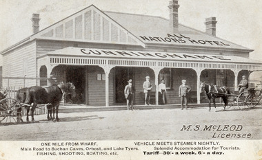 Lakes Entrance Regional Historical Society (operating as Lakes Entrance History Centre & Museum)
Postcard, 1910c
M.S McLeod, Licensee. One mile from wharf, Main Road to Buchan Caves, Orbost and Lake Tyers. Fishing, Shooting, Boating. Vehicle meets steamer nightly. Splendid Accommodation for Tourists. Tariff 30/- a week, 6/- a day.This is the before paired photograph used in the 150 year, Lakes Entrance 1858-2008 display.Also one 12 x 16 framed photograph used in room displayBlack and white postcard of All Nations Hotel, Cunninghame, showing weatherboard building, hipped roof with gable on left side. Roofed veranda across front. Two doors and two sash windows at front. Two bench seats on veranda. Three chimneys. Two horse drawn carriages standing on road, three men and one woman standing before the hotel. Lakes Entrance Victoriahouses, architecture, transport, room display -
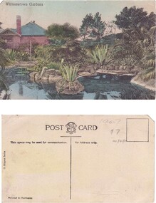 Williamstown Botanic Gardens- Hobsons Bay City Council
Postcard – Williamstown Botanic Gardens, M Schulz, Prague, c1900-1920
The original postcards in this series (2013.002 to 2013.018) were generously loaned to Williamstown Botanic Gardens by a private collector for copying. The Curator’s lodge, designed by the Town Surveyor, HV Champion, was constructed in 1907 following the re-organisation of the north-east corner with the demolition of the old curator's cottage and erection of new gates. Both the lodge and lake (1904) were built during the curatorship of Mr Thake. The logo in the middle of the words ‘POST CARD’ indicates the card was printed by M. Schulz in Prague. Schulz was a long-established company from Prague and printed postcards for customers from worldwide. Schulz printed in photo-chromolithography. The postcards are evidence of the interest the gardens held as a subject for postcard publishers. The text and images provide a snapshot into fashions, social interests and concerns of the time. The professionally produced images provide a pictorial history of Gardens including changing planting styles, various structures and features of the Gardens eg the aviary, cannons, the fountain, the second Curator’s Lodge and gates. The images offer an opportunity to compare garden vistas with the present day.A colour image of the ornamental lake and part of the Curator’s Lodge. The lodge has a green roof, tall brick chimney, is brown timber with brick where the fireplace would be. The small island with a succulent is in the centre of the image. The image looks across the top of the lake where the rock edging can be seen. Reflections of the plantings and lodge can be seen.Front: ‘Williamstown Gardens’. Reverse: Reverse: Centre top ‘POST CARD’ with a logo [MS] in the middle of the words; left side vertical ‘O. Rippon Series’; left side ‘This space may be used for communication.’; right side ‘For Address only.’; left side bottom ‘Printed in Germany’. In pencil top right corner ‘1907 / $7’ (believed to be inserted by the vendor.postcard, gardens, post-card, williamstown-botanic-gardens, hobsons-bay-city-council, curator’s lodge, ornamental lake, succulents, 1907 -
 Lakes Entrance Regional Historical Society (operating as Lakes Entrance History Centre & Museum)
Photograph, 1999
Lakes Entrance Grid reference, Cunninghame 8522.3.4 896.082, on ten acre site with trig point, it is from this point that all the survey for the surrounding areas was undertaken. Part of the Vic Geodetic Survey initiated in 1860 by Ellery Survey started from triangulation base in Werribee. (Grid ref B'dale 8422)Colour photograph of the Victoria Geodetic Survey Triangulation Station, Trig Station, situated off Ocean View Parade, Merrangbaur Hill. Location is indicated by ground point and standing structure, situated on an elevated bush block. Lakes Entrance Victoriahistoric buildings -
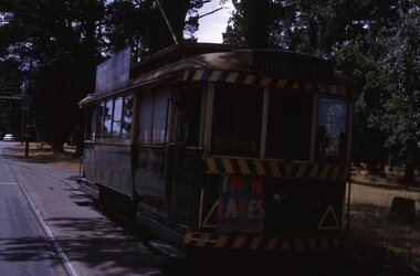 Ballarat Tramway Museum
Slide - 35mm slide/s, Peter Moses, Dec. 1963
Photo of Ballarat trams 11 at Carlton St. Loop apparently taken from another tramcar (See Reg. No. 2028). Tram 11, southbound in Wendouree Parade, showing Lydiard St North. No. 11 has a roof advertisement for SEC Briquettes, Twin Lakes advertisement on the front drivers panel and has tiger stripes but not the white dash under the lights. The driver is leaning out of the front side window of the tram. Kodak cardboard mount slide, taken by Peter Moses December 1963.On back of slide in blue ink "1963 Dec. Trams Lake Wendouree, Ballarat Vic." and bottom right hand corner "P. Moses".tramways, trams, wendouree parade, carlton st, tram 11 -
 Bendigo Historical Society Inc.
Slide - VAL DENSWORTH COLLECTION: DRY LAKE EPPALOCK, May 2004
Slide. Dry Lake Eppalock. A Lagoon in the river in the Lake.slide, bendigo, dry lake eppalock., dry lake eppalock. -
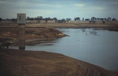 Bendigo Historical Society Inc.
Slide - VAL DENSWORTH COLLECTION: DRY LAKE EPPALOCK, May 2004
Slide. Dry Lake Eppalock. The water tower at the Lake.slide, bendigo, dry lake eppalock., dry lake eppalock. -
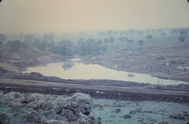 Bendigo Historical Society Inc.
Slide - LAKE EPPALOCK(THE BEGINNING), June 1961
Slide. Lake Eppalock (The Beginning). The construction of the Lake wall.slide, bendigo, lake eppalock(the beginning) -
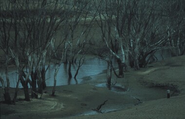
 Stawell Historical Society Inc
Photograph, Botanical Reserve in Stawell West Looking East
Botanical Reserve Stawell West Looking East. Possibly the first church of England in center of photo.Black & white photograph of a lake with trees around the lake.stawell -
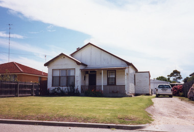 Lakes Entrance Regional Historical Society (operating as Lakes Entrance History Centre & Museum)
Photograph, 2000
House built on Rogby Island by Mitchelson around 1915, relocated to corner of Lake Street and Barkes Avenue around 1920, then to Phillips Street 1962. Front window altered, veranda frieze removed, side extension of veranda removed.Colour photograph of a timber residence at 3 Phillips Street. Gable roof, fibro cement section under gables. Front door has fanlight above, widow light beside door filled in. Barge board of gables typical of dwellings built by Leo Mitchelson, Lakes Entrance Victoriahouses, heritage study -
Lakes Entrance Regional Historical Society (operating as Lakes Entrance History Centre & Museum)
Photograph, Lakes Post Newspaper, 1/11/1991 12:00:00 AM
Also a black and white photograph of Craig Elliot riding in the Tour from Adelaide to Toowomba leaving Lakes Entrance number 04033.1 size 25 x 17 cmBlack and white photograph of seven amputee cyclists riding from Adelaide to Toowomba tenth anniversary of Amputee Sport in Australia raising funds for Paralympics in Barcelona, Joseph Lachman Czech, Pat Garland Steven Smith Craig Elliot Aust, Francisco Trujilla Spanish Alain Renoux, Reno Mistral French taken on their stop in Lakes Entrance Victoriacaravan parks, charities, sports -
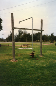 Lakes Entrance Regional Historical Society (operating as Lakes Entrance History Centre & Museum)
Photograph, 1999
In late 1958 bore put down in an attempt to obtain good quality water for a reticulated town water supply. Water unsuitable, but during drought years when water supply from Nicholson River was restricted, water from this bore available for public use. Bore plugged, structure removed December 2000. Site marked with plaque March 2001, by Lakes Entrance Historical Society.Colour photograph of the head works including feed pipe of water bore sunk in late 1958 on the Public Reserve bound by Marine Parade and the highway approach to North Arm Bridge, Lakes Entrance, Victoria.sports -
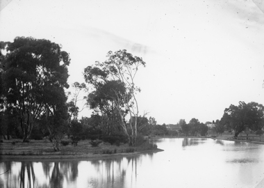
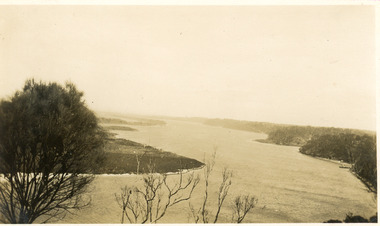 Lakes Entrance Regional Historical Society (operating as Lakes Entrance History Centre & Museum)
Photograph, 1930c
Black and white photograph of Reeves Channel on Lake King, Gippsland Lakes. It shows part of Rigby Island opposite the steep mainland shore of the lake. Lakes Entrance Victoriaislands, waterways, topography -
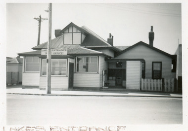 Lakes Entrance Regional Historical Society (operating as Lakes Entrance History Centre & Museum)
Photograph, 1960c
This photpgraph was taken prior to post office upgrade in 1980.|Also enlarged copy 18 x 25.5 cm|This is the before paired photograph used in the 150 year, Lakes Entrance 1858-2008 display.|The after paired photograph number is 01405.1.|Also one 12 x 16 framed photograph used in room display.Black and white photograph showing the front view from Esplanade of Post Office. Power pole, street light and two internal chimneys. Post boxes and weighing machine in alcove to right and Postmasters residence. Lakes Entrance Victoriatownship, postal services, room display -
 Ringwood and District Historical Society
Photograph, Ringwood black and white photographs
Black and white photographMaroondah Hwy. NE. near Ringwood Lake -
Lakes Entrance Regional Historical Society (operating as Lakes Entrance History Centre & Museum)
Postcard, printed in Germany, 5/09/2012 12:00:00 AM
Black and white postcard showing road into Metung around Bancroft Bay showing house on hill in background possibly John McMillans Burilda, lady with hat in foreground viewing scene, boat shed below, Metung VictoriaMetung Gippsland Lakes via Sale routepeople, houses