Showing 110053 items matching "roads"
-
 Whitehorse Historical Society Inc.
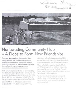
Article, Nunawading Community Hub, Feb 2020
The new Nunawading Community Hub.The new Nunawading Community Hub being built on the site of the former Nunawading Primary School at 96 -106 Springvale Road, Nunawading, is due to be completed mid 2020 and will have a variety of community groups including Meals on Wheels.The new Nunawading Community Hub.nunawading community hub, nunawading primary school no. 4190, meals on wheels, springvale road nunawading no 96 - 106 -
 Eltham District Historical Society Inc
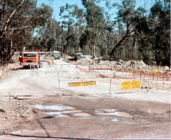
Photograph, Widening of Main Road Bridge over Diamond Creek, Eltham, c.1984, 1984c
Four colour photographs showing road works for widening of the Main Road bridge over Diamond Creek; two showing Main Road south of Mt Pleasant Road and one from the corner of Antoinette Blvd, Eltham, Vic.eltham, main road, diamond creek, main road bridge, bridges, construction -
 Eltham District Historical Society Inc
Photograph, Kinglake near shops
Three colour photographs showing the various road junctions near Kinglake shops. 1. St Andrews Road, Kinglake on left; Toolangi Road to left before roundabout 2. Whittlesea Road on left with Kinglake Hotel 3.kinglake, kinglake whittlesea road, hurstbridge road, kinglake healesville road -
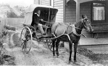 Surrey Hills Historical Society Collection
Photograph, Horse and buggy at 44 Guildford Road Surrey Hills, 1913
Jocelyn Hall indicated in notes that the gentleman could possibly be an estate agent. This was confirmed by a grandson of the original owners. (REF: Email 1/8/2020) The original photos is thought to have been a publicity photo for the real estate agency. Carl Theodore Offszanka (1874-1944) was born in Germany. He is listed in electoral rolls at 44 Guildford Road from 1915, occupation furrier, with his wife Ida (nee Schade, 1882-1963), also born in Germany. They were married in Victoria in 1908. In later electoral rolls at the same address are Erna Helena (b 1913; d 1996) and Maria Eliese (b 1910; m Benedict Francis Rieusset in 1936). Both daughters are listed as typists. Also listed is Bernard George (b 1914; d 1987) who in later electoral rolls is described as a process worker. He served in the AIF in the Second World War. Not listed is Carl Bernard b 1909. The Offszanka family lived at 44 Guildford Road from 1913 until post-1980; they came to Surrey Hills from Richmond. Their home was called 'Westfalia' (ref: 1919 electoral roll), presumably after the region in NW Germany. It is not known when Carl and Ida migrated from Germany. This home has had a 2nd storey added to it in late 1990s. According to a family descendant (REF: Email 1/8/20 from grandson) Carl Theodor Offszanka purchased the home in 1913 for £616. He also purchased the adjoining vacant block of land at 42 Guildford Road and ran a large orchard on it before later selling it. This appears to have been between 1920-1930. The family continued to occupy the house until after 1980 when Erna Helena and Bernard George are listed in the electoral rolls. Our property register lists Erna Helena Offszanka as the last member there. She died on 5 May 1996. The Offszanka family occupied this home from its beginning for over 70 years. Such long-term occupancy by one family is unusual.Black and white photo of a ? dark-stained timber Edwardian home at 44 Guildford Road, Surrey Hills. A hooded buggy is located in the rough driveway at the side of the house. A gentleman in a hat and with a moustache is seated in the buggy. A tall building can be seen in the far distance and a street leading up the hill from Canterbury Road.edwardian style, houses, guildford road, horse drawn vehicle, carl theordore offszanka, miss ida schade, mrs ida offszanka, miss edna helena offszanka, miss marie elsie offszanka, mr bernard george offszanka, estate agent, mr carl bernard offszanka, westfalia -
 Warrnambool and District Historical Society Inc.
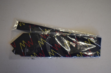
Clothing - Melbourne to Warrnambool Society Tie, 2006
This tie was given in 2007 to members of the Melbourne to Warrnambool Society, a support group to assist the Warrnambool Citizens Road Race Committee to stage the Melbourne to Warrnambool Cycle Road Race in that year. This group was operating for some years early in the 21st century and there were some individual members but mostly the members represented businesses and other organizations in Warrnambool and district. The Melbourne to Warrnambool Road Cycling Classic commenced in 1895 and has run annually for most of the years since that date. The race is the second oldest one-day cycling race in the world and the longest one -day race in the Southern Hemisphere.This tie is of considerable interest as it is a memento of one of the most important events in Warrnambool's sporting calendar, a cycling race known throughout Australia and internationally. This is a man's tie made of polyester material. The tie is navy blue with a pattern in blue, white and yellow, a stylized version of an 'm' and a ''w', representing Melbourne and Warrnambool. It is encased in a clear plastic folder. It has small images of a map of Australia and the logo of the Melbourne to Warrnambool Cycle Road Race.Melbourne to Warrnambool Society Woven and Manufactured in Australiamelbourne to warrnambool cycling road race -
 Melbourne Tram Museum
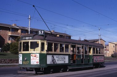
Slide, Keith Kings, 7/07/1969 12:00:00 AM
35mm Kodak white cardboard colour slide by Keith Kings of - W5 807, fitted with square windshields on a route 57, City via North Melbourne in Union Road at cnr of Geddes St, 7/7/1969. Trams adverts for Aspro, Vaseline Hair Cream, Kings StrasburgKeith Kings stamp and number "56-26", with details of exposure. in ink "MMTB W5 with square cornered glass windshield, Union Road, cnr Geddes St Ascot Vale 7/7/69"trams, tramways, w5 class, union road, route 57, city via north melbourne, tram 807 -
 Ballarat Heritage Services
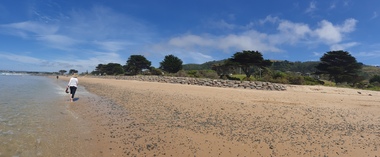
Photograph, Clare Gervasoni, Apollo Bay, Victoria, 24/01/2022
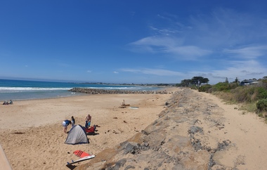
In 2021, the Department of Environment, Land, Water and Planning (DELWP) constructed two new groynes and a section of rock seawall at Apollo Bay to help manage the impacts of coastal erosion. The new 70-meter-long rock groynes run perpendicular to the shoreline and be located just south of the Milford St revetment and to the south of Milford Creek. Sections of rock seawall will be constructed between the two Groynes with an aim to protect the dune, walking path, cypress trees and road from erosion. Colour photograph of a coastal scene at Apollo Bay, featuring new rock wall and groynes to protect the Great Ocean Road from erosion. apollo bay, beach, coast, groyne, rockwall -
 Ballarat Heritage Services
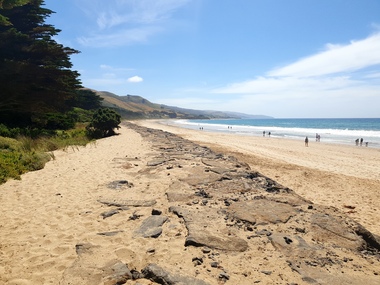
Photograph, Clare Gervasoni, Sea Wall at Apollo Bay, Victoria, 24/01/2022
In 2021, the Department of Environment, Land, Water and Planning (DELWP) constructed two new groynes and a section of rock seawall at Apollo Bay to help manage the impacts of coastal erosion. The new 70-meter-long rock groynes run perpendicular to the shoreline and be located just south of the Milford St revetment and to the south of Milford Creek. Sections of rock seawall will be constructed between the two Groynes with an aim to protect the dune, walking path, cypress trees and road from erosion. Colour photograph of a coastal scene at Apollo Bay, featuring new rock wall and groynes to protect the Great Ocean Road from erosion. apollo bay, beach, coast, groyne, rockwall, sea wall -
 Ballarat Heritage Services
Photograph, Clare Gervasoni, Sea Wall at Apollo Bay, Victoria, 24/01/2022
In 2021, the Department of Environment, Land, Water and Planning (DELWP) constructed two new groynes and a section of rock seawall at Apollo Bay to help manage the impacts of coastal erosion. The new 70-meter-long rock groynes run perpendicular to the shoreline and be located just south of the Milford St revetment and to the south of Milford Creek. Sections of rock seawall will be constructed between the two Groynes with an aim to protect the dune, walking path, cypress trees and road from erosion. Colour photograph of a coastal scene at Apollo Bay, featuring new rock wall and groynes to protect the Great Ocean Road from erosion. apollo bay, beach, coast, groyne, rockwall, sea wall -
 Port Melbourne Historical & Preservation Society
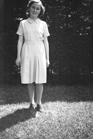
Photograph - Norma Watters in backyard of Williamstown Road home. c 1936
The Watters family moved from Albert Park to Garden City Port Melbourne circa 1934 buying a Bank House at 128 Williamstown Road (later renumbered to 400). The family consisted of Bob Watters senior and his wife Ellen (nee Oakley), children Patsy (b 1920), Bob Junior (b 1922) and Norma (b1924). The children attended Albert Park Primary, Middle Park Central School and then MacRobertson Girls High School and Melbourne Boys High School.Digital photograph of Norma Watters dressed in school uniform outside her home at 124 Williamstown Road (later renumbered to 400) 1935norma watters -
 Port Melbourne Historical & Preservation Society
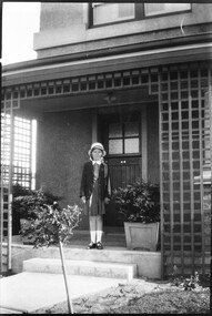
Photograph - Norma Watters outside Williamstown Road home. In school uniform c 1935
The Watters family moved from Albert Park to Garden City Port Melbourne circa 1934 buying a Bank House at 128 Williamstown Road (later renumbered to 400). The family consisted of Bob Watters senior and his wife Ellen (nee Oakley), children Patsy (b 1920), Bob Junior (b 1922) and Norma (b1924). The children attended Albert Park Primary, Middle Park Central School and then MacRobertson Girls High School and Melbourne Boys High School.Digital photograph of Norma Watters dressed in school uniform outside her home at 124 Williamstown Road (later renumbered to 400) 1935norma watters, education - secondary schools -
 Port Melbourne Historical & Preservation Society
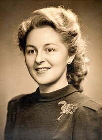
Photograph - Norma Madeline Watters c 1942
The Watters family moved from Albert Park to Garden City Port Melbourne circa 1934 buying a Bank House at 128 Williamstown Road (later renumbered to 400). The family consisted of Bob Watters senior and his wife Ellen (nee Oakley), children Patsy (b 1920), Bob Junior (b 1922) and Norma (b1924). The children attended Albert Park Primary, Middle Park Central School and then MacRobertson Girls High School and Melbourne Boys High School.Digital photograph of Norma Watters dressed in school uniform outside her home at 124 Williamstown Road (later renumbered to 400) 1935norma watters -
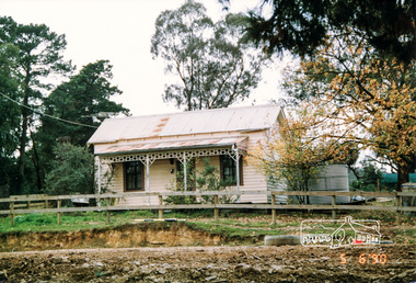
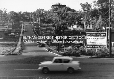 Eltham District Historical Society Inc
Photograph, R.J. Manuell, Woodland Crest, Briar Hill, c.1964
... roads ...View of Squires land which was subdivided for housing - two parts Woodland Crest higher part off Woodland Grove and Calrossi Avenue, Briar Hill showing new roads with curb and channelling and footpaths. No date. Looking up Hyacinth Avenue, Briar Hill from Sherbourne Road. Hibiscus Avenue first on right then Acacia Court. The white house on Hibiscus Avenue still exists (No. 3)Black and white photograph printed with white bordersVerso: COO2briar hill, real estate, woodland grove, squires, roads, acacia court, hibiscus avenuse, hyacinth avenue, woodland crest estate, inge bros pty ltd -
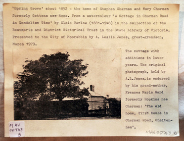 City of Moorabbin Historical Society (Operating the Box Cottage Museum)
Document - Photograph, photocopy, of ‘Spring Grove’ 19th C house, Charman Road, Cheltenham, c1979
In 1852 Stephen Charman purchased 160 acres bounded by Charman Rd and Balcombe Road in an area called Spring Grove , later Cheltenham. A spring ran through the land providing a good source of water. Stephen aged 21 years had arrived in Melbourne 1842 as one of Henry Dendy’s emigrants . His Ship passage was paid by the Colonial Land and Emigration Commission and in return he was required to work on the land of the Henry Dendy Special Survey Brighton 1841. However Henry Dendy could not provide enough work for all the emigrants that arrived and Stephen had to obtain other work. Then sadly his young wife Harriett and their infant died. 1850 Stephen married widow Mary Gettens, a Publican in Little Collins Street, with 5 children. Stephen & Mary built a wattle and daub hut and established a market garden producing marigolds for Martin & Pleasance Pharmacists, Melbourne. They had 7 more children and built a weatherboard cottage that was used for early Methodist Church services. Stephen donated 1 acre to the Methodist Church in 1855 for Chapel , School and Cemetery. This is the weatherboard cottage in the photocopy showing the building extension, The road between Cheltenham and Mentone bears their name. Mary died in 1870 and Stephen remarried 1878 and died in Gippsland 1906. The original Photograph is endorsed by Francis Marie Ward , formerly Hopkins nee Charman who was the grandmother of Mr A.L Jones A photocopy of a black and white photograph of ‘Spring Grove’ , that was the first house in Charman Road , Cheltenham c1852 , showing later extensions. spring grove cottage 1852, schumer l, cheltenham, charman stephen, early settlers, jones a l, gettens mary, rees mary, charman mary, moorabbin, brighton, henry dendy special survey 1841, ward frances marie, charman frances marie -
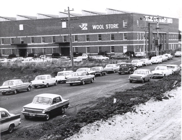 Glenelg Shire Council Cultural Collection
Photograph - Photograph - Portland Wool Brokers Limited, Wool Store, n.d
Port of Portland Authority archives.Front: (no inscriptions) Back: (no inscriptions)port of portland archives -
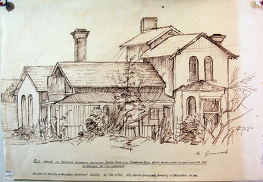 City of Moorabbin Historical Society (Operating the Box Cottage Museum)
Drawing, of early house Cummins Road Moorabbin, c1950
A pencil sketch of an early house on the corner of South Road and Cummins Road by Marian Grimwade. signed : M Grimwademoorabbin, bbrighton, early settlers, bentleigh, nepean highway, arthur's seat road, moorabbin district roads board, market gardeners, artists, grimwade marian, -
 Eltham District Historical Society Inc
Photograph, Cottage, cnr. Reynolds Road and Mount Pleasant Road, Eltham 1990, 1990
Colour photograph of cottage at corner of Mount Pleasant Road and Reynolds Road, Eltham, 1990houses, eltham, mount pleasant road, reynolds road -
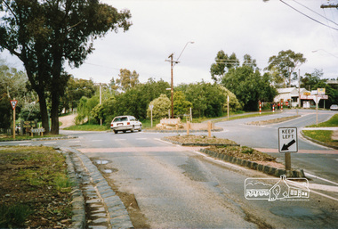
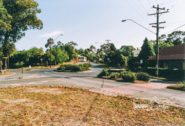 Eltham District Historical Society Inc
Photograph, Main Road, Panton Hill
Six colour photographs of Main Road Panton Hill showing Bishops Road roundaboutmain road, st andrews road, kangaroo ground/st andrews road, bishops road, roundabouts, panton hill -
 Eltham District Historical Society Inc
Photograph, Main Road, Panton Hill
Two colour photographs of Main Road Panton Hill showing Bishops Road roundaboutmain road, st andrews road, kangaroo ground/st andrews road, bishops road, roundabouts, panton hill -
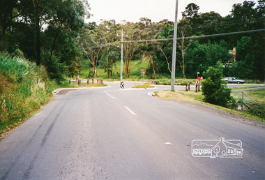 Eltham District Historical Society Inc
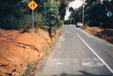
Photograph, Research-Warrandyte Road, Research
Three colour photographs of Research-Warrandyte Road, Research including roundabout at Main Roadresearch, research warrandyte road, warrandyte road, main road, roundabouts -
 Eltham District Historical Society Inc
Photograph, R. Dinsdale, Metery Road, Eltham; 4 Dec 1986, 4/12/86
Colour photograph of Metery Road, Eltham approx. 60m south of Mt Pleasant Roadmetery road, eltham -
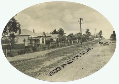 Ringwood and District Historical Society
Photograph, Warrandyte Rd. looking north past Mullum Rd(undated)
Dirt Road with houses. Text on photo states "Warrandyte Road" and "Mullum Rd To Estate"Typed below photograph, "Warrandyte Rd. looking north past Mullum Rd." On back of Oval copy of photograph (original?), is stamped the name "J.B. McAlpin, Estate and Financial Agent, District Government Valuer, Ringwood" -
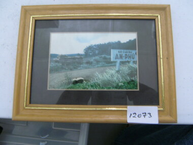 National Vietnam Veterans Museum (NVVM)
Photograph, AN-PHU
Framed colour photograph of road with a sigh "AN-PHU". There is an armoured vehicle on the far side of the roadphotograph, armoured vehicle -
 Box Hill Historical Society
Photograph - White Horse Hotel, 1933
White Horse Hotel on the corner of Elgar Road and Whitehorse Road at the time of demolition in 1933.white horse hotel, hotels, businesses, elgar road, whitehorse road, 1933 -
Whitehorse Historical Society Inc.
Map, Whitehorse Road, Mitcham, 1972
Enlarged aerial photograph of area around intersection of Whitehorse Road and Heatherdale Roads, Mitcham.Enlarged aerial photograph of area around intersection of Whitehorse Road and Heatherdale Roads, Mitcham.Enlarged aerial photograph of area around intersection of Whitehorse Road and Heatherdale Roads, Mitcham.whitehorse road, mitcham, heatherdale road, mitcham, ringwood, maroondah highway, aerial photographs -
Whitehorse Historical Society Inc.
Document, Smith's Milk Bar
School Assignment on description of a Milk Bar on the corner of Beddoe Road and Centre Road, Vermont.School Assignment on description of a Milk Bar on the corner of Beddoe Road and Centre Road, Vermont.School Assignment on description of a Milk Bar on the corner of Beddoe Road and Centre Road, Vermont.milk bars, beddoe road, vermont, centre road, speedy, rob, elaine -
Whitehorse Historical Society Inc.
Article, Old School Charm, 1/04/2014 12:00:00 AM
Advertisement for the sale of Victorian residence 25 Junction Road Blackburn Road - April 2014.Advertisement for the sale of Victorian residence 25 Junction Road Blackburn Road - April 2014.Advertisement for the sale of Victorian residence 25 Junction Road Blackburn Road - April 2014.junction road blackburn north no. 25, sale -
Whitehorse Historical Society Inc.
Map, Springvale Road, 1968
Aerial photograph of cnr Springvale Road and Burwood Highway, south past Highbury Road.Aerial photograph of cnr Springvale Road and Burwood Highway, south past Highbury Road.Aerial photograph of cnr Springvale Road and Burwood Highway, south past Highbury Road.aerial photographs, highbury road, burwood east, burwood highway, burwood east, springvale road, burwood east -
Whitehorse Historical Society Inc.
Document, Eastern Arterial Road, 1986
Eastern Corridor Road Development (ECORD) Doncaster to Ringwood. Road Construction Authority 1986eastern freeway, ringwood bypass, roads and streets -
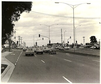 Whitehorse Historical Society Inc.
Photograph, Springvale Road looking South, 1/09/1983 12:00:00 AM
Donor developed Educational Programme at Blackburn Lake.Black and white photo of Springvale Road looking South. Intersects with Whitehorse Road, Nunawading.meagher, dorothy, springvale road, nunawading, whitehorse road, nunawading