Showing 28492 items
matching street street
-
 City of Ballarat Libraries
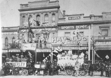
Photograph, Boer War Celebrations, Ballarat circa 1902
... sturt street...The parade was held in Sturt Street near Grenville Street...City of Ballarat Libraries Eureka Centre Eureka Street ...The parade was held in Sturt Street near Grenville Street. In the background can be seen the Union Hotel, Owens Sports Store, and Kline's Bakery.building, commercial, hotel, celebrations, boer war, sturt street, owens sport store, kline's bakery -
 City of Kingston
Pamphlet - Colour, Highett Town, 1888
... , and incorporating Major Street and Train Street...., and incorporating Major Street and Train Street. The developing urban area ...Sales plan for land in the suburb of Highett, bounded by Highett Road, Worthing Terrace and the railway line, and incorporating Major Street and Train Street.The developing urban area of Highett within the City of Kingston. This land sale pamphlet illustrates the subdivision of land within the municipality and the changing demographic of the district as new houses are constructed close to infrastructure.Colour pamphlet advertising for private sale the Station Entrance Estate, Highett. Incorporates a map of the estate bordered by Wickham Road, Railway Parade, Highett Road and Point Nepean Road.land sales, highett -
 Clunes Museum
Photograph
... STREET SCENE OF FRASER STREET CLUNES. BURNS HOTEL...Clunes Museum 36 Fraser Street Clunes goldfields POSTCARD ...POSTCARD SENT TO MRS L. MCLENNAN CLUNES. FROM US. MARYBOROUGH, ROCKHAMPTON QUEENSLANDSTREET SCENE OF FRASER STREET CLUNES. BURNS HOTEL, E.S.A.BANK BUILDING (NOW R.S.L. HALL) AND STATE SAVINGS BANK. ALSO VISIBLE IS SEVEN STARS HOTELCOMPLIMENTS OF THE SEASON FROM ALL AT MARYBOROUGH, ROCKHAMPTON QUEENSLAND MS.postcard, e.s.a. bank now r.s.l. building, greeting card -
 Port Melbourne Historical & Preservation Society
Plan, Bay Street, C. 1990
... Bay Street...Bay Street...A proposed plan for the development of Bay Street, Port...Bay Street Built environment - commercial A proposed plan ...A proposed plan for the development of Bay Street, Port Melbourne. The Street plan shows suggestions for tree planting, verandah changes, proposed open space & building use.bay street, built environment - commercial -
Port Melbourne Historical & Preservation Society
Photograph - Turner Family home, 190 Nott Street (renumbered as 114 Nott Street), Port Melbourne, 1940s
... Turner Family home, 190 Nott Street (renumbered as 114 Nott... Turner family home, 190 Nott Street: 114 Nott Street in the 1980s... Melbourne Town Hall 333 Bay Street Port Melbourne melbourne built ...B&W lasercopy, one of four on a page of photos of Bert Turner family home, 190 Nott Street: 114 Nott Street in the 1980s. (Nott Street numbers have changed; see also item 914 re furnishings)built environment - domestic, bert turner -
 Wodonga & District Historical Society Inc
Photograph - Codling Collection 01 - High Street East - from Mahony’s to Finishing Touch, 1980s
... Codling Collection 01 - High Street East - from Mahony’s...Codling Collection 01 - High Street East - from Mahony’s...Eastern side of High Street, Wodonga - High Street East... Wodonga Aljoy Studio W. J. Buckpitt Eastern side of High Street ...Miss Olive Codling was a Foundation Member and a Life Member of the Wodonga Historical Society. Many of her prize-winning photos are held in the Society Collection. She also held a range of roles and committee positions in a wide range of Wodonga community organisations. These included the Horticultural Society, the Wodonga Arts Council, the Wodonga Camera Club and the Wodonga Lapidary Club. This photo collection is significant as it documents how the businesses and buildings in Wodonga have evolved and contributed to community throughout the 20th century.Eastern side of High Street, Wodonga - High Street East - from Mahony’s to Finishing Touch. Other businesses include Riah Hairdresser, W.J. Buckpitt Solicitors, Aljoy Studio, Hotham Building Society, Security Permanent Building Societywodonga businesses, high st wodonga, aljoy studio, w. j. buckpitt -
 Ringwood and District Historical Society
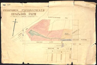
Map, Proposed Improvements to Ringwood Park (Ringwood Lake) dated 14 January 1927
... of the map, south of the railway line, showing proposed streets..., showing proposed streets - Graham Road, Anderson Street and Adams ...Proposed Improvements to Ringwood Park (Ringwood Lake) dated 14 January 1927, signed Cr McCaskill. Main Road is Whitehorse Road (Maroondah Highway), and Mt Dandenong Road is incorrectly labelled Whitehorse Road. The map shows Rosedale Crescent and Railway Parade, both of which exist in 2024. On the bottom of the map, south of the railway line, showing proposed streets - Graham Road, Anderson Street and Adams Street - in preparation for the sale of the Theo Anderson property. That area is now Bedford Park. -
 Eltham District Historical Society Inc
Photograph, Peter Pidgeon, View from Bolton Street, Eltham, 2 Aug. 2022
... View from Bolton Street, Eltham...View looking east from Bolton Street near Brougham Street... melbourne View looking east from Bolton Street near Brougham Street ...View looking east from Bolton Street near Brougham Street, Eltham taken from PETStock looking over the industrial area of ElthamBorn Digitaleltham, bolton steet, industry, petstock eltham central, little eltham -
 Uniting Church Archives - Synod of Victoria
Photograph, Undated c.1900
... in Albert Street Sebastopol in 1861. The church moved from Albert... Street Malvern East melbourne The "Zion" Welsh Independent Chapel ...The "Zion" Welsh Independent Chapel was established in Albert Street Sebastopol in 1861. The church moved from Albert Street to Walker Street in around 1882.B & W exterior photograph of the Zion Congregational Church, Sebastopol.From J.D. Northey to Rev S. M ... (?) Taken around the turn of the century before the hedge was planted.sebastopol, welsh, congregational, chapel, zion -
 Stawell Historical Society Inc
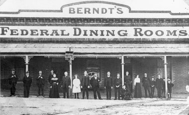
Photograph, Berndt’s Federal Dining Rooms in Upper Main Street Big Hill c1900
... Berndt’s Federal Dining Rooms in Upper Main Street Big Hill...Berndt’s Federal Dining Rooms upper Main Street Big Hill... grampians Berndt’s Federal Dining Rooms upper Main Street Big Hill ...Berndt’s Federal Dining Rooms upper Main Street Big Hill beside Forester Hotel on corner of Main Street and Patrick Street c1900stawell -
 Stawell Historical Society Inc
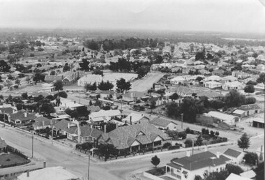
Photograph, Panorama of Stawell from the top of St. Matthew’s Spire looking West with the Childe and Ligar Street intersection in the foreground
... looking West with the Childe and Ligar Street intersection in the... looking West. 502 School visible. Childe Street and Ligar Street... looking West. 502 School visible. Childe Street and Ligar Street ...Panorama of Stawell from the top of St. Matthew’s Spire looking West. 502 School visible. Childe Street and Ligar Street intersection in foreground.stawell -
Stawell Historical Society Inc
Photograph, Trio Doll Factory on the corner of St George and Victoria Streets after the 1947 fire
... Street and Victoria Street.... Street and Victoria Street. Stawell Trio Doll Factory ...Trio Doll Factory c1947. Series of photographs taken after the 1947 fire. Building was situated on the corner of St George Street and Victoria Street.stawell -
 Bendigo Historical Society Inc.
Photograph - FOGGIT JONES, c1930
... in the Wade Street -Maple Street area of Golden Square. EST 1910... Inc. History House 11 Mackenzie Street Bendigo goldfields ...black and white photo : View from Foggitt Jones looking towards Bendigo 1930. Houses in foreground, poppet head left side mullock heap behind, Bendigo valley in background. (Situated in the Wade Street -Maple Street area of Golden Square. EST 1910)Sacred Heart Cathedral and St Paul's Catedral can been seen in the distance. Physical description: unmounted black and white photo.Edwin G Adamson, A>R>P>S Charters House, 165 Collins St, Melbourne, Tel. F 6330organization, business, small goods -
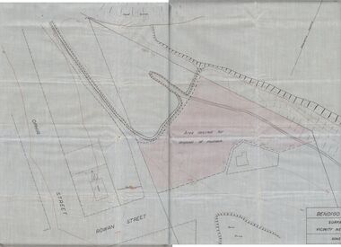 Bendigo Historical Society Inc.
Plan - MCCOLL, RANKIN AND STANISTREET COLLECTION: PLAN OF MONUMENT HILL BATTERY
... Gwynne) for disposal of mullock. Plan shows Ophir Street, Rowan...) for disposal of mullock. Plan shows Ophir Street, Rowan Street, Written ...Pale blue waxed paper plan. Written on back of plan ' Monument Hill Battery site, area desired by Bendigo Mines (Nell Gwynne) for disposal of mullock. Plan shows Ophir Street, Rowan Street, Written on bottom RH corner 'Bendigo Mines Ltd., surface plan, vicinity Nell Gwynne Shaft, Scale 1" = 40' Magnetic north marked, sand dumps and contour lines.bendigo, business, mccoll, rankin & stanistreet -
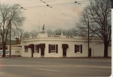 Bendigo Historical Society Inc.
Photograph - BENDIGO HOTEL COLLECTION: NATIONAL HOTEL, HIGH STREET, BENDIGO
... BENDIGO HOTEL COLLECTION: NATIONAL HOTEL, HIGH STREET...national hotel high street...Colour photograph: National Hotel, corner of High Street... Inc. History House 11 Mackenzie Street Bendigo goldfields ...Colour photograph: National Hotel, corner of High Street and Violet Street, Bendigo. White painted exterior, brown painted name, brown awnings over windows, brown shutters alongside window. Photo appears approx early 1980's.bendigo, hotel, national hotel high street -
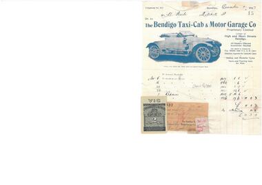 Bendigo Historical Society Inc.
Financial record - BENDIGO TAXI-CAB & MOTOR GARAGE INVOICE
... for goods and repairs. Located at Corner of High Street and Short... Inc. History House 11 Mackenzie Street Bendigo goldfields ...Bendigo Taxi-Cab & Motor Garage Co. Invoice to Mr W Beebe for goods and repairs. Located at Corner of High Street and Short Street. Dated December 1 1917. Receiopt for payment attached to the invoice. Paid on January 30 1918. -
 Buninyong & District Historical Society
Photograph - B/W photograph, Mr C J Brooks, Holy Trinity Church of England, cnr Scott & Warrenheip Sts. Buninyong, July 1993
... , corner of Scott Street and Warrenheip Street, Buninyong. Rev..., Buninyong Town Hall Learmonth Street Buninyong goldfields Original ...Original brick church/school (1857) and bluestone church (1862)BW photograph, of Holy Trinity Church of England church, corner of Scott Street and Warrenheip Street, Buninyong. Rev. Garrett John Russell arrived Buninyong 1857 when vicarage and school were built, Church of Holy Trinity opened in 1862.anglican, buninyong, church of england, bluestone, building -
 Kew Historical Society Inc
Plan, Melbourne & Metropolitan Board of Works : Borough of Kew : Detail Plan No.1561, 1905
... and environmental features. Each plan covers one or two street blocks... bordered by Burke Road, Loxton Street, Mount Street and Barkers... features. Each plan covers one or two street blocks (roughly six ...The Melbourne and Metropolitan Board of Works (MMBW) plans were produced from the 1890s to the 1950s. They were crucial to the design and development of Melbourne's sewerage and drainage system. The plans, at a scale of 40 feet to 1 inch (1:480), provide a detailed historical record of Melbourne streetscapes and environmental features. Each plan covers one or two street blocks (roughly six streets), showing details of buildings, including garden layouts and ownership boundaries, and features such as laneways, drains, bridges, parks, municipal boundaries and other prominent landmarks as they existed at the time each plan was produced. (Source: State Library of Victoria). This plan forms part of a large group of MMBW plans and maps that was donated to the Society by Mr Poulter, City Engineer of the City of Kew in 1989. Within this collection, thirty-five hand-coloured plans, backed with linen, are of statewide significance as they include annotations that provide details of construction materials used in buildings in the first decade of the 20th century as well as additional information about land ownership and usage. The copies in the Public Record Office Victoria and the State Library of Victoria are monochrome versions which do not denote building materials so that the maps in this collection are invaluable and unique tools for researchers and heritage consultants. A number of the plans are not held in the collection of the State Library of Victoria so they have the additional attribute of rarity.Original survey plan, issued by the MMBW to a contractor with responsibility for constructing sewers in the area identified on the plan within the Borough of Kew. The plan was at some stage hand-coloured, possibly by the contractor, but more likely by officers working in the Engineering Department of the Borough and later Town, then City of Kew. The hand-coloured sections of buildings on the plan were used to denote masonry or brick constructions (pink), weatherboard constructions (yellow), and public buildings (grey). MMBW Detail Plan 1561 outlines those residences in the area bordered by Burke Road, Loxton Street, Mount Street and Barkers Road that had been constructed by 1905 when the land was surveyed. At this time, the area nearest Burke Road had been subdivided and developed whereas the lands to the west were as yet undeveloped. The houses represented are not named on the Plan.melbourne and metropolitan board of works, detail plans, mmbw 1561, cartography -
![Map, Millbank Estate Bacchus Marsh Thursday 4th October 1888 [Land sales], 1924](/media/collectors/5e461d8021ea67224c82f2a1/items/67765662eb6d2cbd24e0797f/item-media/67765682eb6d2cbd24e07a41/item-fit-380x285.jpg) Bacchus Marsh & District Historical Society
Bacchus Marsh & District Historical SocietyMap, Millbank Estate Bacchus Marsh Thursday 4th October 1888 [Land sales], 1924
... . The lots had frontages to Ballarat Road (Main Street), Maddingley.... The lots had frontages to Ballarat Road (Main Street), Maddingley ...The Millbank Estate was a parcel of land close to the centre of the shopping area of Bacchus Marsh which was sub-divided and offered for sale in 62? lots on the 4th October 1888. The lots had frontages to Ballarat Road (Main Street), Maddingley Road (now Grant Street), Turner Street, Millbank Street, Clarinda Road (now Clarinda Street), and an unnamed street south of Turner Street (possibly known as Grant Street at this time) which connected to Maddingley Road through the vicinity of the present day Bacchus Marsh Hospital. This was a significant sub-division of land and represented a major expansion of residential housing in Bacchus Marsh in the late 19th century. The map includes a wealth of detail about the time of the sale, where it will take place, who the selling agents were, the deposit terms for purchases and details of a special train from Melbourne to Bacchus Marsh on sale day. The location of the allotments in relation to the shopping and commercial area of Bacchus Marsh, Maddingley and the railway station are indicated on an inset map within the overall map and poster. The Millbank Estate area was an area which had once belonged to the Grant family who were prominent early citizens of Bacchus Marsh and lived in a house in this area known as 'Millbank'.This land sale map is a typical example of housing estate land sales advertising maps produced by real estate agents in this era. The map is significant for the detailed information it provides about when and where land was sold for new housing estates in Bacchus Marsh in the late nineteenth century.Single page map showing land allotments for sale at auction in Bacchus Marsh in October 1888. A significant portion of the map is missing from the bottom right side. land sales bacchus marsh, land subdivsion bacchus marsh, housing estates land sales bacchus marsh, grant family bacchus marsh, millbank estate land sales -
Port Melbourne Historical & Preservation Society
Photograph - Friends of the Park float, Port Melbourne Festival, Pat Grainger, Feb 1989
... at Station Street carport, 88 Ingles Street: Jan Fly and ?... Melbourne Town Hall 333 Bay Street Port Melbourne melbourne ...This float was created by members of Friends of the Park, a group formed in 1987 against government proposals to turn the railway and reservation into a grand boulevard to service the proposed Sandridge City 'Bayside' development. Members worked for months to make the decorations, added to a trailer. During the festival procession sausages were BBQ'd on the trailer and handed out to the crowd. On arrival at Murphy's Reserve all floats were put out of sight, and few saw the results of their efforts.One of 16 photos of Friends of the Park float for the February 1988 Port Melbourne Festival: Float construction at Station Street carport, 88 Ingles Street: Jan Fly and ?celebrations fetes and exhibitions, public action campaigns, town planning - proposals shelved - bayside, jan fly, friends of the park, port melbourne festival -
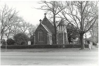
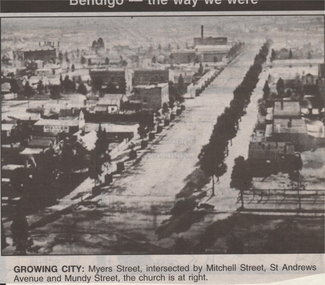 Bendigo Historical Society Inc.
Newspaper - JENNY FOLEY COLLECTION: GROWING CITY
... city: Myers Street, intersected by Mitchell Street, St Andrews... Inc. History House 11 Mackenzie Street Bendigo goldfields ...Bendigo Advertiser ''The way we were'' from 1999. Growing city: Myers Street, intersected by Mitchell Street, St Andrews Avenue and Mundy Street, the church is at right.newspaper, bendigo advertiser, the way we were -
Port Melbourne Historical & Preservation Society
Plan, Bay Street Site Analysis, C. 1990
... Bay Street Site Analysis...Bay Street...A site analysis plan for the development of Bay Street...Bay Street Built environment - commercial A site analysis ...A site analysis plan for the development of Bay Street, Port Melbourne. The Street plan shows suggestions for tree planting, verandah changes, proposed open space & building use.bay street, built environment - commercial -
 Kew Historical Society Inc
Plan, Melbourne & Metropolitan Board of Works : Borough of Kew : Detail Plan No.1569, 1905
... and environmental features. Each plan covers one or two street blocks...). This plan covers parts of Sackville Street, John Street, Thomas... features. Each plan covers one or two street blocks (roughly six ...The Melbourne and Metropolitan Board of Works (MMBW) plans were produced from the 1890s to the 1950s. They were crucial to the design and development of Melbourne's sewerage and drainage system. The plans, at a scale of 40 feet to 1 inch (1:480), provide a detailed historical record of Melbourne streetscapes and environmental features. Each plan covers one or two street blocks (roughly six streets), showing details of buildings, including garden layouts and ownership boundaries, and features such as laneways, drains, bridges, parks, municipal boundaries and other prominent landmarks as they existed at the time each plan was produced. (Source: State Library of Victoria)This plan forms part of a large group of MMBW plans and maps that was donated to the Society by the Mr Poulter, City Engineer of the City of Kew in 1989. Within this collection, thirty-five hand-coloured plans, backed with linen, are of statewide significance as they include annotations that provide details of construction materials used in buildings in the first decade of the 20th century as well as additional information about land ownership and usage. The copies in the Public Record Office Victoria and the State Library of Victoria are monochrome versions which do not denote building materials so that the maps in this collection are invaluable and unique tools for researchers and heritage consultants. A number of the plans are not held in the collection of the State Library of Victoria so they have the additional attribute of rarity.Original survey plan, issued by the MMBW to a contractor with responsibility for constructing sewers in the area identified on the plan within the Borough of Kew. The plan was at some stage hand-coloured, possibly by the contractor, but more likely by officers working in the Engineering Department of the Borough and later Town, then City of Kew. The hand-coloured sections of buildings on the plan were used to denote masonry or brick constructions (pink), weatherboard constructions (yellow), and public buildings (grey). This plan covers parts of Sackville Street, John Street, Thomas Street and Cotham Road, and includes several very large houses in Sackville Street. Job Smith built ‘Berrington’ in about 1888-90 for himself, and ‘Pomeroy’ (now ‘Merridale’) in 1885 for James Mickleburgh. ‘Heathfield’ was built in 1888 for Henry Eeles, and was one of many fine homes in Kew, Hawthorn and surrounding suburbs designed by prolific architect John Beswicke; it later became “La Verna” and was a Franciscan monastery. Similarly, in Cotham Road, we can see ‘Bella Vista’ (now demolished), and ‘Charleville’, with its double-storeyed arcade frontage, built in 1889 for Charles Donaldson whose family occupied it until 1939. This was renamed ‘Ross House’ by the second owner, Dr. Thomas King, and then substantially restored in the 1960s by the Stillwell family, well known as car drivers and dealers. Bella Vista (later ‘Malinda’) was originally designed by the architect Robert Haddon and built for Abel Hoadley, inventor of the Violet Crumble Bar and many other delicious delicacies. He began by manufacturing jams and pickles in South Melbourne using fruit from his own orchard in East Burwood.melbourne and metropolitan board of works, detail plans, mmbw 1569, cartography -
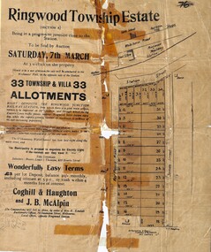 Ringwood and District Historical Society
Flyer, Auction Sale Advertisements - Ringwood Township Estate, Ringwood, Victoria - 1914
... ), Station Street, and James Street. Agents in conjunction - Coghill... Road (later Wantirna Road), Station Street, and James Street ...Advertisements for auction sale of Ringwood Township Estate (Section A) - Saturday, 7th March (1914), showing subdivision layout, terms of sale, and summary of local features and services. Un-named newspaper clipping advertising this auction also attached.Subdivision includes West Prussia Road (later Wantirna Road), Station Street, and James Street. Agents in conjunction - Coghill & Haughton and J.B. McAlpin. Sale by order of Mrs. E. Kendall. -
 Greensborough Historical Society
Photograph - Digital Image, Greensborough Primary School Gr2062, 1960s
... grimshaw street greensborough... Grimshaw Street, and view up Grimshaw Street toward Main Street... Primary School No.2062 from Grimshaw Street, and view up Grimshaw ...Photographs of Greensborough Primary School No.2062 from Grimshaw Street, and view up Grimshaw Street toward Main Street, before Greensborough Plaza was built.Digital copy of colour photographs.greensborough primary school, grimshaw street greensborough -
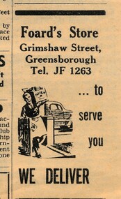 Greensborough Historical Society
Advertisement - Digital image, Diamond Valley Local, Foard's Store, 15/12/1954
... at 119 Grimshaw Street and Henry Street corner.... was a Greensborough general store at 119 Grimshaw Street and Henry Street ...These advertisements were collected from the Diamond Valley Local newspaper. Foard's Store was a Greensborough general store at 119 Grimshaw Street and Henry Street corner.This advertisement is for a Greensborough based shop which no longer operates.Digital copy of newspaper advertisement.foards store -
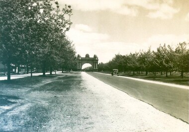 City of Ballarat Libraries
Photograph - Card Box Photographs, View along Sturt Street to the Arch of Victory, circa 1950
... View along Sturt Street to the Arch of Victory, circa 1950....Sturt Street...View west from Gillies Street along Sturt Street to Arch...City of Ballarat Libraries Eureka Centre Eureka Street ...View west from Gillies Street along Sturt Street to Arch of Victory. Sheep can be seen grazing in the future Ballarat High School grounds.sturt street, arch of victory, streetscape, public, vehicle -
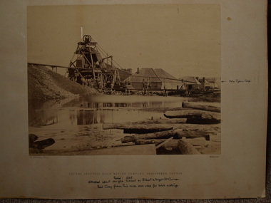 Clunes Museum
Photograph, C. NETTLETON PHOTOGRAPHER, APPROX. 1865
... STREET AND ANGUS STREET CORNER. RED CLAY FROM THIS MINE... YDS SW OF ALBERT AND ANGUS STREET CORNER. RED CLAY FROM... STREET AND ANGUS STREET CORNER. RED CLAY FROM THIS MINE ...THIS MINE WAS SITUATED ABOUT 100 YARDS SOUTH WEST OF ALBERT STREET AND ANGUS STREET CORNER. RED CLAY FROM THIS MINE WAS USED FOR BRICK MAKING..1 SEPIA PHOTOGRAPH OF CLUNES ALLUVIAL GOLD MINING CO. .2 SEPIA PHOTOGRAPH OF POPPET HEAD-MINERS ON PLATFORM-THATCHED ROOF BUILDINGS, SCATTERING OF LARGE LOGS IN FOREGROUND, USED FOR FIRES. .3 COPY OF ABOVE PHOTOGRAPH IN BLACK AND WHITE (POSTCARD SIZE).1 PRINTED: CLUNES ALLUVIAL GOLD MINING COMPANY REGISTERED CLUNES .2 PRINTED ON FRONT : ALLUVIAL GOLD MINING COMPANY REGISTERED CLUNES HANDWRITTEN: PERIOD 1865. SITUATED ABOUT 100 YDS SW OF ALBERT AND ANGUS STREET CORNER. RED CLAY FROM THIS MINE WAS USED FOR BRICK MAKINGphotographs, mining, clunes alluvial mining company -
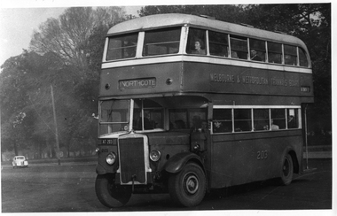 Melbourne Tram Museum
Photograph - Set of 11 Black and White photograph, Ken Flood, 18/04/1974 12:00:00 AM
... TD5c - Turning from Nicholson Street into Gertrude Street... Leyland TD5c - Turning from Nicholson Street into Gertrude Street ...Set of 11 black and white photographs sent to Keith Kings received from Ken Flood 4/6/1975. .1 - Bus No 203 1940 Leyland TD5c - Turning from Nicholson Street into Gertrude Street. - bound for Northcote. .2 - Bus No 201 1940 Leyland TD5c - In Nicholson Street at Albert Street - Photo. bound for Northcote .3.- Bus No 492 1943 Ford Austerity - at Queens Pde Clifton Hill - Note the Pram and Passenger bus sign by the front doorway. Photo not dated. .4 - Bus No 365 1948 OPS1 - Nicholson Street at Victoria Pde. bound for East Brunswick. Photo not dated. .5 - Bus No 325 1950 OPS4 - Nicholson Street at Victoria Pde. bound for East Brunswick. Photo not dated. Bus did not enter service until 1950. .6 - Bus No 500 1943 Ford Austerity - Marine Pde. Point Ormond. Note the Pram bus sign by the front door. .7 - Bus No 19 1938 Leyland Cub (diesel) with Preston Workshops body. - Lonsdale Street at William Street. W2 No 305 passes behind the bus. Late 1940's photo. .8 - Bus No 143 1940 Leyland TS8c drop enter - in Russell Street at LaTrobe Street bound for North Kew. (Belford Road via Collingwood). Photo not dated. .9 - Bus No 9 1938 Leyland Cub (diesel) with Preston Workshops body. - in Russell Street at LaTrobe Street bound for North Carlton .10 - Bus No 4 1938 Leyland Cub (Diesel) with Preston Workshops body - in Lonsdale Street at William Street. note destination not reset for the return trip. .11 - Bus No 150 1940 Leyland TS11c Drop enter - Nicholson Street at Victoria Pde. Photo not dated. Most of the photos dated 9/6/1949 unless noted otherwise. Notes on photos provided by Rod Atkins - see htd5860doc.pdfOn rear of the photos in ink; .1 - MMTB 203 9/6/49 - K Flood .2 - MMTB 201 - 9/6/49 - K Flood .3 - MMTB Ford #492 - K Flood .4 - MMTB #365 - K Flood .5 - MMTB #325 - K Flood .6 - MMTB #500 Pt Ormond 6/6/49 - K Flood .7 - MMTB #19 9/6/49 - K Flood .8 - MMTB #143 - K Flood .9 - MMTB #4 9/6/49, K Flood .10 - MMTB #4 9/6/49, K Flood .11 - MMTB #150 - K Floodtrams, tramways, buses, double deck buses, prams, mmtb buses, austerity buses, w2 class, tram 305, bus 203, bus 201, bus 492, bus 365, bus 500, bus 19, bus 143, bus 9, bus 4, bus 150, leyland, ford motor company, td5c class, ops1 class, ops4 class, ts8c class, cub class, ts11c class -
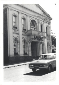 Kew Historical Society Inc
Photograph - Former Kew Town Hall, Walpole Street, 1970
... Former Kew Town Hall, Walpole Street...kew town hall -- walpole street... of the (former) Kew Town Hall in Walpole Street between High Street... street local government -- kew civic buildings -- kew (vic.) town ...The Municipality of Kew was granted independence in 1860. It was declared a borough in 1863, a town in 1910 and a city in 1921. In 1994, Kew was amalgamated into the new City of Boroondara.Black and white photographic positive of the front of the (former) Kew Town Hall in Walpole Street between High Street and Malmsbury Street, on the west side where Woolworth's supermarket now stands. The photograph, from August 1970 shows the detailing of the Italianate rendered-brick facade, added in the 1880s when the hall was renovated. The earliest building on the site was the Kew Athenaeum Hall (built 1860) which was purchased by Kew Council in 1865. The Town Hall was sold to Woolworth's and subsequently demolished in 1972 when the civic offices were transferred to a new building on the corner of Charles Street and Cotham Road."Old Kew Town Hall / Walpole St / Aug 1970/ Gift of Stewart West 1990"kew town hall -- walpole street, local government -- kew, civic buildings -- kew (vic.), town halls -- melbourne (vic.)