Showing 11008 items matching " land"
-
 Bendigo Historical Society Inc.
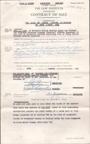
Document - H. A. & S. R. WILKINSON COLLECTION: CONTRACT OF SALE
Contract of sale of land by public auction dated 29th August, 1956 between Farmers and Citizens Trustees Company Bendigo executor of the will of F. R. Schilling deceased (vendor) and Mr. A. C. & Mrs. A. Sprawson (purchaser). Property: land that lies above the depth of 100 feet below the surface of all that land containing 35 perches and 8/10 of a perch being allotment 20 section 49B comprised in Crown Grant volume 2193 folio 493 situate No. 120 Rowan Street, Bendigo. Price: 2,725 pounds.organization, business, h.a. & s.r wilkinson real estate -
 Bendigo Historical Society Inc.
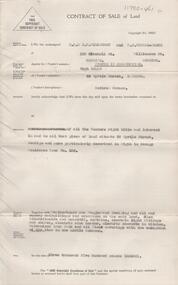
Document - H. A. & S. R. WILKINSON COLLECTION: CONTRACT OF SALE
Contract of sale of land dated 14th may, 1956 between Mr. H Nolan (vendor) and ? Property: land situate 55 Myrtle Street, Bendigo land described in Right to Occupy residence area no. 125, together with weatherboard and rough cast dwelling and all sundry outbuildings, also blinds, curtains, electric light fittings and shades, electric sink heater, electric stovette in kitchen, galvanised iron tank and all floor coverings with the exception of the lino in the middle bedroom. Price: 3,500 pounds.organization, business, h.a. & s.r wilkinson real estate -
 Bendigo Historical Society Inc.
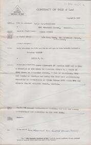
Document - H. A. & S. R. WILKINSON COLLECTION: CONTRACT OF SALE
Contract of sale of land dated 28th June, 1955 between Mrs. A Spence (vendor) and Mr. P. Sheedy (purchaser). Property: land being Crown allotment3A section 119C and having a frontage of 161 links to Anderson Street by a depth of 164.5 links to Valentine Street Parish of Sandhurst City of Bendigo, being land described in certificate of title volume 6579 folio 775 and situate No. 44 Anderson Street, Bendigo, together with weatherboard dwelling and all sundry outbuildings. Price: 2,200 pounds.organization, business, h.a. & s.r wilkinson real estate -
 Bendigo Historical Society Inc.
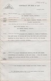
Document - H. A. & S. R. WILKINSON COLLECTION: CONTRACT OF SALE
Contract of sale of land dated 13th December, 1951 between Mr. A. W. Bynon (vendor) and Mr. H. P. Schade Jnr. (purchaser). Property: land being allotment 286 section K, Parish of Sandhurst City of Bendigo, land described in Crown grant volume 575 folio 114996 and situate corner Slack & Buckley Streets, Bendigo, together with 4 roomed weatherboard dwelling and all sundry outbuildings, all window blinds, curtains and all linos on the floors. Price: 1,350 pounds.organization, business, h.a. & s.r wilkinson real estate -
 Bendigo Historical Society Inc.
Document - H. A. & S. R. WILKINSON COLLECTION: CONTRACT OF SALE
Contract of sale dated 26th July, 1952 between Mr. E. K. Meager (vendor) and Mr. S. M. Trewin & Mrs. G. C. Unthank (purchaser). Solicitor for vendor: Kiddle, Briggs & Willox, 15 Queen Street, Melbourne. Property: land being part of Crown allotment 18 section 28C City of Bendigo Parish of Sandhurst being land comprised in certificate of title volume 3897 folio 779322 and which said land is situate in Kennedy Street, Bendigo. Price: 1,320 pounds.organization, business, h.a. & s.r wilkinson real estate -
 Bendigo Historical Society Inc.
Document - H.A. & S.R. WILKINSON COLLECTION: CONTRACT OF SALE
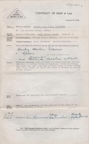
This business was owned by father and son, Henry Archibald Wilkinson and Samuel Ronald "Ron" Wilkinson. Henry (1882-1954) was born in Shepparton and died in Bendigo. He was married to Grace Hovendon in 1908. Samuel Ronald "Ron" (1914-1995), Henry's son, was married to Florence Jean McKerlie in 1937.Contract of sale of land dated 11th May, 1957 between Mr. W.B. Nicholls (seller) and Misses D.M. & L.G. Smith. For land being lot 8 on vendor's plan of subdivision by Mr. Surveyor Pritchard, dated 2nd May, 1957 having a frontage of 59 feet to Alamein Court by a depth of 100 feet, being part allotment 7 section 31A land described in Crown grant volume 8113 folio 731. Subject to any registered appurtenant easements. Price 3,600 pounds.organization, business, h.a. & s.r wilkinson real estate -
 Bendigo Historical Society Inc.
Document - H.A & S.R. WILKINSON COLLECTION: CONTRACT OF SALE
This business was owned by father and son, Henry Archibald Wilkinson and Samuel Ronald "Ron" Wilkinson. Henry (1882-1954) was born in Shepparton and died in Bendigo. He was married to Grace Hovendon in 1908. Samuel Ronald "Ron" (1914-1995), Henry's son, was married to Florence Jean McKerlie in 1937.Contract of sale of land dated 29th May, 1954 between Mrs. E.M. & Mr. H.A. Knight (sellers) and Mr. W.H. Randall (buyer) for land being lot 2 on plan of subdivision No. 19227 being parts of lots 27 and 28 on plan of subdivision No. 4134 being part of Crown allotment 97 and being the balance of the land comprised in certificate of titles volume 6441 folios 021 and 022 and situate Albion Street, Bendigo. Together with weatherboard dwelling and all sundry. Price 2,200 pounds.organization, business, h.a. & s.r wilkinson real estate -
 Phillip Island and District Historical Society Inc.
Photograph Album, Kodak, Phillip Island Cemetery, c 1990
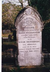
The Album was compiled by Nancy McHaffie late 1990's, with the assistance of Edith Jeffery's, with her book "Garden of Memories" and extensive knowledge of Phillip Island. The Cemetery lies back from the road and is surrounded by Manna Gums, rare Peppermint Gums, Blackwoods and other native trees. In all 25 acres of land were set aside as Crown Land in the land settlement of 1868. There are 6.2 acres of wetlands near the cemetery entrance.466-23: Joseph Richardson came to Australia in 1837 from Liverpool, England. Sarah Arbuckle and her two sisters arrived in 1850. Sarah and Joseph were married when gold was discovered in Victoria. They went to the diggings and had some success. Joseph bought land on Phillip Island when it was open to freehold selection in 1868. The family moved to Phillip Island shortly afterwards, to a house they built on a hill west of Cowes. They called their home "Everton" after a Liverpool suburb. The house still stands in Church Street, known as "Tallawalla". 466-24: The McIlwraith family came from Melton, Victoria to Heath Hill, Rhyll in 1869. They played an important part in the early history of Phillip Island. James was a foundation member of the Trust, John and Alan played their part in the local scene. John was President and Alan Secretary of the Cemetery Trust for many years.phillip island cemetery, nancy mchaffie, edith jeffery -
 Phillip Island and District Historical Society Inc.
Photograph Album, Kodak, Phillip Island Cemetery, c 1990
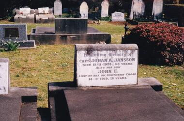
The Album was compiled by Nancy McHaffie late 1990's, with the assistance of Edith Jeffery's, with her book "Garden of Memories" and extensive knowledge of Phillip Island. The Cemetery lies back from the road and is surrounded by Manna Gums, rare Peppermint Gums, Blackwoods and other native trees. In all 25 acres of land were set aside as Crown Land in the land settlement of 1868. There are 6.2 acres of wetlands near the cemetery entrance.466-44: Captain Johan Jansson. Capatain Jansson was born in 1862 and came to Australia on the ship "Nosstaljee" in 1886. In 1887 he came to the Island and started work with Captain Lock. He bought land at Rhyll in 1891 and built a house two years later, now known as Jansson's Cottage. Johan married Evelyn Power.. a daughter of Captain Powell. He purchased the ketch "Swan" and later :Stephen" in 1914. They took chicory, seaweed, hay and other farm produce to Melbourne, returning with general cargo. Captain Jansson died in 1928 aged 66 years. 466-45: Evelyn Jansson. Evelyn was the daughter of Captain Powell. She married Johan Jansson on her 18th birthday. She died 1971 aged 95 years. Their daughter Mavis is buried with Evelyn - died 1971 aged 72 years.phillip island cemetery, johan jansson, evelyn jansson, mavis jansson, nancy mchaffie, edith jeffery -
 Bendigo Historical Society Inc.
Document - H.A. & S.R. WILKINSON COLLECTION: CONTRACT OF SALE
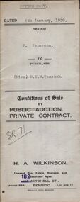
Conditions of sale by private contract dated 4th January, 1938 between F. Peterson (seller) and Miss B.E.M. Tancock (buyer) for land situate No.84 lily Street, Bendigo, being land described in Crown grant volume 2650 folio 529876, together with 5-roomed weatherboard dwelling and all sundry.organization, business, h.a. & s.r wilkinson real estate -
 Bendigo Historical Society Inc.
Document - H.A. & S.R. WILKINSON COLLECTION: CONDITION OF SALE
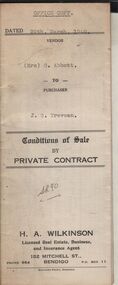
Conditions of sale by private contract dated 29th March, 1940 between Mrs. G. Abbott (seller) and J.S. Trevean (buyer) for land situate Trotter Street, Bendigo, being land described in right to occupy residence area No. 5180, together with 4-roomed dwelling and all sundry. Price 100 pounds.organization, business, h.a. & s.r wilkinson real estate -
 Bendigo Historical Society Inc.
Document - H.A. & S.R. WILKINSON COLLECTION: CONTRACT OF SALE
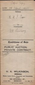
Conditions of sale by private contract dated 1st April, 1933 between H.M.I. Prior (seller) and A.E. Ramsay (buyer) for land situate Brown Street, Eaglehawk, being land described in certificate of registration as residence area No. 3916, together with 4-roomed weatherboard dwelling and all sundry. Price 150 pounds.organization, business, h.a. & s.r wilkinson real estate -
 Bendigo Historical Society Inc.
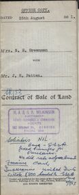
Document - H.A. & S.R. WILKINSON COLLECTION: CONTRACT OF SALE
Contract of sale of land dated 25th August, 1951 between Mrs. S.E. Greenman (seller) and Mr. J.H. Patten (buyer) for land situate No. 1 Bobs Street, Bendigo described in right to occupy residence area No. 266, together with 4-roomed weatherboard dwelling and all sundry. Price 1,050 pounds.organization, business, h.a. & s.r wilkinson real estate -
 Bendigo Historical Society Inc.
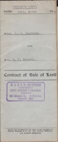
Document - H.A. & S.R. WILKINSON COLLECTION: CONDITION OF SALE
Contract of sale of land dated 24th March, 1954 between miss A.M. Houlihan (seller) and Mr. W.T. Priest (buyer) for land situate 12 Reserve Street Eaglehawk described in Right to Occupy Residence Area No. 5362, together with weatherboard dwelling and all sundry. Price 1,000 pounds. Vendor's copyorganization, business, h.a. & s.r wilkinson real estate -
 Bendigo Historical Society Inc.
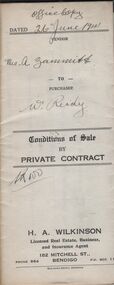
Document - H.A. & S.R. WILKINSON COLLECTION: CONDITION OF SALE
Conditions of sale by private contract dated 26th June, 1941 between Mrs A. Zammitt (seller) and W. Reidy (buyer) for land situate in Barrell Street Eaglehawk being the land described in right to occupy residence area right No. 7903, together with 5-roomed weatherboard dwelling and all sundry. Price 150pounds.organization, business, h.a. & s.r wilkinson real estate -
 Bayside Gallery - Bayside City Council Art & Heritage Collection
Photograph, Department of Crown Lands and Survey, Victoria, Melbourne Project: Brighton and Hampton, 1976
The Department of Crown Lands and Survey (1857-1983) was responsible for the administration of survey and mapping and the sale, occupation and management of crown land throughout its existence. This aerial photograph shows parts of Brighton and Hampton and was taken on 1 December 1976. brighton, department of crown lands and survey, aerial photograph, bayside, port phillip bay, map, cartographic material, melbourne project 1976, brighton yacht club, middle brighton baths, hampton, green point, brighton beach, south road, the esplanade, hampton street -
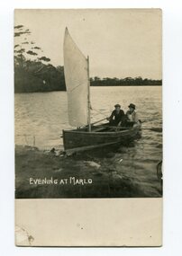 Orbost & District Historical Society
black and white photograph, early 20th century?
This photograph shows Mac and May Stuart landing at Marlo in their small boat.A black / white photograph / postcard of two people sitting in the stern of a small sailboat pulling in to land on a beach. It appears to be late in the day.on front - "Evening at Marlo" on back - " Mac & May Stuart, 57 years ago" ; "Mrs????M Marshall Bairnsdale"marlo stuart-may-mac -
 Greensborough Historical Society
Article, Printer Unknown, Greensborough, 1840o
Details the history of the current Greensborough township. It also mentions the early settlement of Kangaroo Point.Mentions early settlers such as William Poulter, James Chapman, James Mann and Edwin Willis Magger (Maygar).2 page printed document outlining the activities and motives of Edward Bernard Green, an early owner of the area of land that became Greensborough.Pencilled words on front page. greensborough, kangaroo point, edward green, poulter, mann, chapman, magger, mayger, melbourne to sydney mail contract -
 Glenelg Shire Council Cultural Collection
Slide - Slide - Cashmore Airport, Portland, 1980s
Coloured slide. Site of an airport before any construction. Green, flat large area of land, rising up slightly in background.portland airport, cashmore airport, construction, engineering -
 Ringwood and District Historical Society
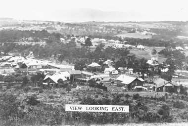
Photograph, View from Loughnan's Hill looking east c1930
Black and white photograph taken from vacant land on hill. Scene overlooks housing and trees. Mountains in background. (2 copies)Typed on photograph, "View looking east". Typed below photograph, "View from Loughnans Hill c1930. Maroondah Highway, Catholic church all top right corner". -
 Ringwood and District Historical Society
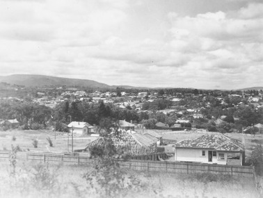
Photograph, View from Loughnan Rd. looking south east over Harrison Street/Andrew Street corner, c.1949
Black and white photograph showing some vacant land and new houses under construction. Developed area in background. (3 copies)Typed below photograph, "View from Loughnan Rd. looking south east, 1949". Written on backing sheet, "View from Loughnan Rd. to corner Harrison and Andrew Street, c1949". -
 Flagstaff Hill Maritime Museum and Village
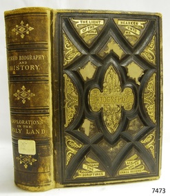
Book, Sacred Biography and History
Sacred Biography and History Explorations in the Holy Land Compiled by Osmond Tiffany Publisher: J W Lyon and Co Date: 1878 Label on spine cover with typed text RH 270 HAR Pastedown end page has sticker from Warrnambool Mechanics Institute and Free Librarywarrnambool, shipwrecked-coast, flagstaff-hill, flagstaff-hill-maritime-museum, maritime-museum, shipwreck-coast, flagstaff-hill-maritime-village, shipwrecked-artefact, book, sacred biography and history, osmond tiffany -
Glenelg Shire Council Cultural Collection
Photograph - Photograph - land recalamtion, n.d
Port of Portland Authority Archivesport of portland archives, land reclamation, portland -
Glenelg Shire Council Cultural Collection
Photograph - Photograph - Land Reclamation, n.d
Port of Portland Authority ArchivesBack: B in blue biroport of portland archives, portland harbour -
Glenelg Shire Council Cultural Collection
Photograph - Photograph - Land Reclamation, n.d
Port of Portland Authority ArchivesBack: B in blue biroport of portland archives, land reclamation -
Port Melbourne Historical & Preservation Society
Document, "Plan of Town of Melbourne 1837 A.D.", 1937
Photocopy of "Plan of Town of Melbourne 1837 A.D." Also showing first land sales, historical memoranda, and an alphabetical list of purchases.town planning, town of melbourne -
Port Melbourne Historical & Preservation Society
Document - Submission, Inquiry into "Land Transport to Webb Dock", 1981
Submissions concern impacts, implications and future directions regarding freight movement into and out of Webb Dock.Submissions and transcripts from the State Development Committee "Inquiry into Land Transport to Webb Dock", 1981 City Of Port Melbourne submissionport of melbourne authority, transport - railways, transport - roads, local government - city of port melbourne, webb dock, urban freight group, bill saggers -
Port Melbourne Historical & Preservation Society
Document - Submission, Inquiry into "Land Transport to Webb Dock", 1981
Submissions concern impacts, implications and future directions regarding freight movement into and out of Webb Dock.Submissions and transcripts from the State Development Committee "Inquiry into "Land Transport to Webb Dock", 1981 Urban Freight Group submission"RPW"port of melbourne authority, transport - railways, transport - roads, local government - city of port melbourne, webb dock, urban freight group, bill saggers -
Port Melbourne Historical & Preservation Society
Document - Transcript, Inquiry into "Land Transport to Webb Dock", 1981
Submissions concern impacts, implications and future directions regarding freight movement into and out of Webb Dock.Submissions and transcripts from the State Development Committee "Inquiry into "Land Transport to Webb Dock", 1981 Transcript of Proceedings, 25.08, 1981"RPW"port of melbourne authority, transport - railways, transport - roads, local government - city of port melbourne, webb dock, urban freight group, bill saggers -
Port Melbourne Historical & Preservation Society
Letter - Department of Lands and Survey granting land for temporary reserve, 18 Mar 1860
Handwritten letter from Dept of Lands and Survey granting Crown land for temporary reserve as site for abattoirs 18 March 1861local government - borough of sandridge, industry - noxious, department of lands and surveys, clement hodgkinson