Showing 4498 items matching " surveys"
-
 Bendigo Historical Society Inc.
Map - PANNOOMILLOO : COUNTY OF BENDIGO, 1957
... Drawn and reproduced at the Department of Lands and Survey, Melbourne 1957. Price 2/-. (number 83 in map cupboard 1)...Drawn and reproduced at the Department of Lands and Survey, Melbourne 1957. Price 2/-. (number 83 in map cupboard 1) Map PANNOOMILLOO : COUNTY OF BENDIGO. ...Map. Pannoomilloo, County of Bendigo, Pannoobamawm, Milloo, Diggorra, Warragamba. Elmore Cohuna Railway. Waranga Mallee Channel. By authority W.M. Houston, Government Printer, Melbourne. Drawn and reproduced at the Department of Lands and Survey, Melbourne 1957. Price 2/-. (number 83 in map cupboard 1)W.M. Houston, Government Printer, Melbourne.map, bendigo, pannoomilloo -
Bendigo Historical Society Inc.
Map - NOLAN : COUNTY OF BENDIGO, 22-7-13
... Photo-Lithographed at the Deptartment of Lands and Survey, Melbourne by W.J. Butson 22-7-13. Price 1/-. ...Photo-Lithographed at the Deptartment of Lands and Survey, Melbourne by W.J. Butson 22-7-13. Price 1/-. ...Map. Nolan, County of Bendigo, Egerton, Elmore, Goornong, Northern Railway, Campaspe River. By authority A.J.Mullett, Government Printer, Melbourne. Photo-Lithographed at the Deptartment of Lands and Survey, Melbourne by W.J. Butson 22-7-13. Price 1/-. (number 79 in map cupboard 1)A.J. Mullett, Government Printer, Melbourne.map, bendigo, nolan -
Bendigo Historical Society Inc.
Map - NOLAN : COUNTY OF BENDIGO, 7-5-30
... Drawn and reproduced at the Department of Lands and Survey, Melbourne, Victoria.7-5-30. Price 2/-. ...Drawn and reproduced at the Department of Lands and Survey, Melbourne, Victoria.7-5-30. Price 2/-. ...Map. Nolan, County of Bendigo, Egerton, Elmore, Goornong, Campaspe River, Northern Railway. By Authority H.J. Green, Government Printer, Melbourne. Drawn and reproduced at the Department of Lands and Survey, Melbourne, Victoria.7-5-30. Price 2/-. (number 78 in map cupboard 1)H.J. Green, Government Printer, Melbourne.map, bendigo, nolan -
Bendigo Historical Society Inc.
Map - JANIEMBER WEST : COUNTY OF BENDIGO, September 1955
... Drawn and reproduced at the Department of Lands and Survey, Melbourne. Price 2/-.September 1955. ...Drawn and reproduced at the Department of Lands and Survey, Melbourne. Price 2/-.September 1955. ...Map. Janiember West, County of Bendigo, Powlett, Janiember East, Jarklan, Kinypanial, River Loddon, Kelsh's Lagoon. By authority W.M. Houston, Government Printer. Drawn and reproduced at the Department of Lands and Survey, Melbourne. Price 2/-.September 1955. (number 64 in map cupboard 1)W.M. Houston, Government Printermap, bendigo, janiember west -
Bendigo Historical Society Inc.
Map - EGERTON : COUNTY OF BENDIGO, 1-3-30
... Photo-Lithographed at the Department of Lands and Survey, Melbourne. Price 2/-. 1-3-30. (number 47 in map cupboard 1)...Photo-Lithographed at the Department of Lands and Survey, Melbourne. Price 2/-. 1-3-30. (number 47 in map cupboard 1) Map EGERTON : COUNTY OF BENDIGO. ...Map. Egerton, County of Bendigo, Minto, Diggorra, Elmore, Nolan, Goornong, Bagshot, Whirrakee. Bendigo Creek. By authority J.J. Green, Govt. Printer. Photo-Lithographed at the Department of Lands and Survey, Melbourne. Price 2/-. 1-3-30. (number 47 in map cupboard 1)J.J. Green, Govt. Printer.map, bendigo, egerton -
Bendigo Historical Society Inc.
Map - RAVENSWOOD : COUNTY OF BENDIGO, 1971
... Ravenswood, County of Bendigo, Township of Ravenswood, County of Talbot, Bradford; Walmer; Harcourt; Lockwood; Mandurang; Sutton Grange.By Authority C.H.Rixon, Government Printer, Melbourne.Drawn and Reproduced at the Dept. of Crown Lands and Survey, Victoria. 1971. Price $1.00 (number 5 in map cupboard 1)...Ravenswood, County of Bendigo, Township of Ravenswood, County of Talbot, Bradford; Walmer; Harcourt; Lockwood; Mandurang; Sutton Grange.By Authority C.H.Rixon, Government Printer, Melbourne.Drawn and Reproduced at the Dept. of Crown Lands and Survey, Victoria. 1971. Price $1.00 (number 5 in map cupboard 1) Map RAVENSWOOD : COUNTY OF BENDIGO. ...Map. Ravenswood, County of Bendigo, Township of Ravenswood, County of Talbot, Bradford; Walmer; Harcourt; Lockwood; Mandurang; Sutton Grange.By Authority C.H.Rixon, Government Printer, Melbourne.Drawn and Reproduced at the Dept. of Crown Lands and Survey, Victoria. 1971. Price $1.00 (number 5 in map cupboard 1)C.H.Rixon, Government Printermap, bendigo, ravenswood -
 Bendigo Historical Society Inc.
Document - BUSINESS LICENSE PETITION
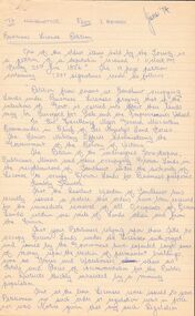
... The petitioners hoped that the land upon which they have erected their premises may be surveyed and put up for public auction and that the premises on the land are valued and allowed for....The petitioners hoped that the land upon which they have erected their premises may be surveyed and put up for public auction and that the premises on the land are valued and allowed for. ...Handwritten and typed copies of a Business License Petition. Petition is about storekeepers, etc. who have built their businesses on Crown Land. The petitioners hoped that the land upon which they have erected their premises may be surveyed and put up for public auction and that the premises on the land are valued and allowed for.document, names of bendigo pioneers, business license petition, business license petition, i hendry, major general macarthur -
 Bendigo Historical Society Inc.
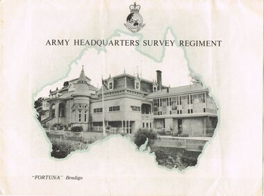
Document - LYDIA CHANCELLOR COLLECTION; 'FORTUNA' BENDIGO
... On the front cover are the words, ' Army Headquarters Survey Regiment 'Fortuna' Bendigo.' It contains black and white photos of 'Fortuna' inside and out and also an outline in print of the history of 'Fortuna.' ...On the front cover are the words, ' Army Headquarters Survey Regiment 'Fortuna' Bendigo.' It contains black and white photos of 'Fortuna' inside and out and also an outline in print of the history of 'Fortuna.' ...An information brochure in black, white and turquoise. On the front cover are the words, ' Army Headquarters Survey Regiment 'Fortuna' Bendigo.' It contains black and white photos of 'Fortuna' inside and out and also an outline in print of the history of 'Fortuna.' C1950s. Also included is a small black and white photo of 'Fortuna.'buildings, government, 'fortuna', lydia chancellor, collection, australian army, royal australian survey corps, 'fortuna, ' mansions, buildings, houses, house, lansell family -
 Ringwood and District Historical Society
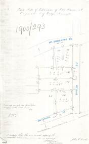
Document - Copy of Lands Department Field Notes - Subdivision of Police Reserve at Ringwood, County of Mornington, Field Notes 1900/293 - Part of O.P. R72C surveyed 1900
... Foolscap size photocopy of survey map with handwritten notations. References include Mount Dandenong Road, Dublin Road, Patterson Street, Melbourne to Lilydale railway line, I certify that this is a correct copy of recorded observations made by my assistant (signed) W. ...Field Notes 1900/293 - Part of O.P. R72C surveyed 1900 Document Copy of Lands Department Field Notes - Subdivision of Police Reserve at Ringwood, County of Mornington ...Foolscap size photocopy of survey map with handwritten notations. References include Mount Dandenong Road, Dublin Road, Patterson Street, Melbourne to Lilydale railway line, I certify that this is a correct copy of recorded observations made by my assistant (signed) W. Thorn, Staff Surveyor. -
 Glenelg Shire Council Cultural Collection
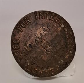
Functional object - Survey Mark
... Survey...It looks as though several words have been chipped off or out from the middle of the top. Look to be ' Survey Mark'...Glenelg Shire Council Cultural Collection History House Cliff Street Portland great-ocean-road Survey Surveying Tool Land Marker Penalty 50 for interference Brass mushroom shaped object. ...Brass mushroom shaped object. The stalk end has a split in the bottom like an old peg. The top of the marker has 50 pound penalty for interference on it. It looks as though several words have been chipped off or out from the middle of the top. Look to be ' Survey Mark'Penalty 50 for interferencesurvey, surveying tool, land, marker -
 Federation University Historical Collection
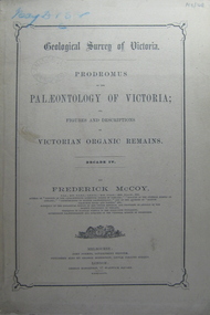
Book, Prodromus of the Palaeontology of Victoria No iv, 1876 (exact)
... At head of title: Geological Survey of Victoria. Illustrations, plates in b/w; 32 p. ...At head of title: Geological Survey of Victoria. Illustrations, plates in b/w; 32 p. ...This publication consists of many Decades which contain "figuers and descriptions of the fossil organic remains to be used for the determination of the geological ages of the different geological formations of the country." (p. 3). Frederick McCoy was born in Dublin, Ireland in 1817. He was a Professor of Natural Sciences, University of Melbourne 1854-1899. McCoy lectured in geology, zoology, chemistry, mineralogy, geography and botany. In 1858 He became the Director of the National Museum of Victoria and the President of the Royal Society of Victoria in 1864. In 1888, McCoy was awarded FRS for work in Palaeontology in Ireland, England and Australia. He died in his office while correcting examination papers in 1899A Paperback cover book. Decade IV. Title is written in black on front cover and on title page. At head of title: Geological Survey of Victoria. Illustrations, plates in b/w; 32 p. It includes figures and descriptions of Victorian Organic Remains and contents of Decades on the back cover of the book.australia palaeobotany, victoria palaeontology, geological survey of victoria, frederick mccoy, organic remains -
Box Hill Historical Society
Book, Collyer, Eric, Doncaster: a short history, 1994
... This book covers the history of Doncaster from 1837, when it was first surveyed by Robert Hoddle, to 1994. Information is included on the early settlers, fruit growing, churches, schools, homes, the postal and public transport service, sport and shopping. ...Box Hill Historical Society Box Hill Heritage Centre Suite 7 Town Hall Hub Box Hill melbourne Local history Doncaster Pioneers Templestowe Churches Orchards Box Hill Doncaster Tram Doncaster Tower This book covers the history of Doncaster from 1837, when it was first surveyed by Robert Hoddle, to 1994. Information is included on the early settlers, fruit growing, churches, schools, homes, the postal and public transport service, sport and shopping. ...This book covers the history of Doncaster from 1837, when it was first surveyed by Robert Hoddle, to 1994. Information is included on the early settlers, fruit growing, churches, schools, homes, the postal and public transport service, sport and shopping. A map of historic places in Doncaster is included. Photos. Indexlocal history, doncaster, pioneers, templestowe, churches, orchards, box hill doncaster tram, doncaster tower -
 Villa Alba Museum
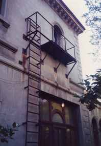
Photograph - Exterior wall, entrance to vestibule and fire escape, c.1987
... In December 1987, Mockridge Stahle & Mitchell Pty Ltd Architects prepared ‘Villa Alba Survey: A Report on the fabric for Mount Royal Hospital’ of which this photograph is a part. ...This was a benchmark survey against which future conservation and restoration activities can be measured. villa alba Museum conservation photographs Victorian architecture fire escapes In December 1987, Mockridge Stahle & Mitchell Pty Ltd Architects prepared ‘Villa Alba Survey: A Report on the fabric for Mount Royal Hospital’ of which this photograph is a part. ...Built for William and Anna-Maria Greenlaw in the early 1880s, and with interiors decorated by the Paterson Bros, Villa Alba remained in private ownership until 1949. From 1950, the house was owned by a number of institutions. By 1984, the Villa Alba Preservation Society had been formed, and three years later, the Mount Royal Hospital granted a 25-year lease to Kew Council. In 2004, the title to Villa Alba was passed by the Victorian Government to The Villa Alba Museum Incorporated. The Museum, at 44 Walmer Street, Kew, is now a cultural institution committed to the collection, study and display of 19th century interior decorative finishes, and the components of 19th and 20th century interior decoration. This is one of a number of historically and aesthetically significant photos of the interiors and exterior of Villa Alba when it was still owned by the Mount Royal Hospital, showing twentieth century accretions and deterioration of the historic fabric of the building. This was a benchmark survey against which future conservation and restoration activities can be measured.In December 1987, Mockridge Stahle & Mitchell Pty Ltd Architects prepared ‘Villa Alba Survey: A Report on the fabric for Mount Royal Hospital’ of which this photograph is a part. The photo is of the Exterior (east) wall (east), the entrance to vestibule and an external fire escape. [The fire escape was later removed.]villa alba museum, conservation photographs, victorian architecture, fire escapes -
University of Melbourne, Burnley Campus Archives
Plan, Circus Site, c. 1990
... ...survey...(1) Copy of Plan: City of Richmond City Engineers Department Circus Site: includes Descriptions of Site Preparation, Plant List and Plant Order List. (2) On tracing paper: Plant Plan. (3) On tracing paper: "Yarra Vegetation Survey - Site 3," Plant Plan...University of Melbourne, Burnley Campus Archives 500 Yarra Boulevard Richmond melbourne circus survey Richmond vegetation survey Colin Mock Yarra River (1) Handwritten on reverse, "Richmond Council - Yarra Blvd to Bridge Road." (1) Copy of Plan: City of Richmond City Engineers Department Circus Site: includes Descriptions of Site Preparation, Plant List and Plant Order List. (2) On tracing paper: Plant Plan. (3) On tracing paper: "Yarra Vegetation Survey - Site 3," Plant Plan Circus Site Plan ...(1) Copy of Plan: City of Richmond City Engineers Department Circus Site: includes Descriptions of Site Preparation, Plant List and Plant Order List. (2) On tracing paper: Plant Plan. (3) On tracing paper: "Yarra Vegetation Survey - Site 3," Plant Plan(1) Handwritten on reverse, "Richmond Council - Yarra Blvd to Bridge Road."circus, survey, richmond, vegetation survey, colin mock, yarra river -
 Bendigo Military Museum
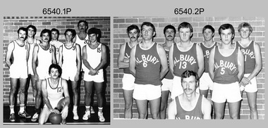
Photograph - Annual Sport Competition: Flag Day - Army Survey Regiment Verses School of Military Survey, Bendigo, 1977
... Annual Sport Competition: Flag Day - Army Survey Regiment Verses School of Military Survey, Bendigo...This set of 33 photographs of sports action was taken on Flag Day, an annual sports competition between the Army Survey Regiment (ASR) and the School of Military Survey (SMS), at Bendigo on the 13th of May 1977. ...This is a set of 33 photographs of sports action was taken on Flag Day, Army Survey Regiment (ASR) versus the School of Military Survey (SMS), at Bendigo on the 13th of May 1977. ...Army Survey Regiment...Annual Sport Competition: Flag Day - Army Survey Regiment Verses School of Military Survey, Bendigo Photograph Annual Sport Competition: Flag Day - Army Survey Regiment Verses School of Military Survey, Bendigo Army Survey Regiment ...This set of 33 photographs of sports action was taken on Flag Day, an annual sports competition between the Army Survey Regiment (ASR) and the School of Military Survey (SMS), at Bendigo on the 13th of May 1977. Softball was held at Beischer Park Strathdale, sailing was most likely held at Lake Eppalock, rifle shooting at Wellsford Rifle Range and tug-of-war at Fortuna. The venues for basketball, golf, squash and volleyball are unknown. The two RA Svy units took turns each year to host the event. Personnel from the ASR’s Detachment located at Bonegilla were part of the SMS’s teams. The day competition usually comprised basketball, cross country, golf, sailing, squash softball, tennis, rifle shooting, touch football, tug-of-war and volleyball. The evening competition often included darts, carpet bowls, hookey, quoits and snooker. See items 6025.15P for photo proofs of sports action and 6326.25P for softball action and taken on the day. There are numerous duplicates previously published from these photo proofs; however they are inferior in quality.This is a set of 33 photographs of sports action was taken on Flag Day, Army Survey Regiment (ASR) versus the School of Military Survey (SMS), at Bendigo on the 13th of May 1977. The photographs were printed on photographic paper and are part of the Army Survey Regiment’s Collection. The black and white photographs were scanned at 300 dpi. .1) - Photo, black & white, 1977, Basketball. ASR Team Back row L to R: unidentified, Stuart Symonds, Bruce Gordon. Front row L to R: unidentified (x2), Bill Jones, unidentified. Sitting: unidentified. .2) - Photo, black & white, 1977, Basketball. SMS Team Back row L to R: Duncan Burns, Stuart Thaxter, unidentified (x2). Front row L to R: Owen Moss, unidentified, Steve Hansen. Sitting: unidentified. .3) to .5) - Photo, black & white, 1977. Basketball action. .6) - Photo, black & white, 1977, Golf - L to R: Kevin ‘Chuck’ Berry, George Austen, unidentified, Roy Morgan. .7) - Photo, black & white, 1977, Golf - L to R: Stan Vote, Gordon Lowery, Peter Warwick, John ‘JB’ Barrie. .8) & .9) - Photo, black & white, 1977, ASR Golf Team – Back row L to R: Peter Warwick, unidentified, Graeme Jeffers, John Sinclair. Front row L to R: Stan Vote, Roy Morgan, George Austen, Len Thirlwell. .10) & .11) - Photo, black & white, 1977, SMS Golf Team - Back row L to R: Kevin ‘Chuck’ Berry, unidentified, Gordon Lowery. Front row L to R: unidentified, Peter Hardy, unidentified, John ‘JB’ Barrie. .12) & .13) - Photo, black & white, 1977, Golf. Teeing off – unidentified. .14) - Photo, black & white, 1977, Golf. Teeing off – John Sinclair. .15) - Photo, black & white, 1977, Golf. Putting – Stan Vote. .16) - Photo, black & white, 1977, Golf. Putting - Peter Warwick. .17) - Photo, black & white, 1977, Golf. Putting – Roy Morgan. .18) - Photo, black & white, 1977, ASR Rifle Shooting Team - Back row L to R: Paul Davis, unidentified (x2), Max Neil, Rhys De Laine. Front row L to R: Tony Lawler, Rene van den Tol, unidentified, Warren ‘Waldo’ Shirley. .19) - Photo, black & white, 1977, ASR Rifle Shooting Team – L to R: unidentified (x4), 2nd back right: Tony Lawler, unidentified. .20) - Photo, black & white, 1977, SMS Rifle Shooting Team - Back row L to R: John Ashby, unidentified (x3). Front row L to R: Dave Murphy, Wolfgang Thun, John ‘Stormy’ Tempest, unidentified. .21) - Photo, black & white, 1977, Softball – L to R: Jenny Haddow, Debbie Brown, unidentified umpire. .22) - Photo, black & white, 1977, ASR & SMS Sailing Teams – Back row L to R: Chris Osborne, Josh De Groot, unidentified (x2), Greg Francis-Wright, Peter Breukel. 3rd row L to R: Marrianne (Van De Zee) De Groot, unidentified, Kim Reynolds, Alex Cairney, unidentified, Sam Chambers. 2nd row L to R: Les Dixon, Jim Macdonald, unidentified, George Graham, Ted ‘FOT’ Burgess. Front row L to R: Doug Carswell, Alan Adsett, Peter Mustart, Tony Waldon, Dave Miles. .23) - Photo, black & white, 1977, Sailing on Lake Eppalock, Victoria. .24) - Photo, black & white, 1977, SMS Squash Team – Back row L to R: Graham Squire, Peter Constantine AM, Peter Colwell, Bill Boyd OAM, Front row L to R: unidentified, Dick Barwald, Colin Darch, unidentified. .25) - Photo, black & white, 1977, ASR Squash Team – Back row L to R: Andy Wilson, Terry Danger, Errol Fletcher, Dennis Puniard. Front row L to R: Lynn Johnson, Kerry Browne. .26) - Photo, black & white, 1977, ASR Tug-of-War Team: Back row L to R: Russ Mollenhauer, Neville Stone, Jim Cook, Jeff Willey, unidentified (x3). Front row L to R: unidentified, John ‘Flash’ Anderson, Mick ‘Buddha’ Ellis, Ken ‘Sluggo’ Slater, Rob ‘Boges’ Bogumil, Frank Lenane, unidentified. .27) - Photo, black & white, 1977, SMS Tug-of-War Team: Back row L to R: unidentified, Stuart Thaxter, Steve Hansen, unidentified (x2). Front row L to R: Kim Lenson, unidentified (x4), Jamie ‘Fish’ McRae. .28) & .29) - Photo, black & white, 1977, ASR Tug-of-War Team in action. .30) - Photo, black & white, 1977, Volleyball action. .31) - Photo, black & white, 1977, Volleyball action. Chris Edwards blocking. .32) & .33) - Photo, black & white, 1977, Volleyball action..1P to .33P –No personnel are identified. ‘Regiment v School 13 May 1977’ annotated on cover sleeve.royal australian survey corps, rasvy, army survey regiment, army svy regt, fortuna, asr, school of military survey, flag day -
 City of Greater Bendigo - Civic Collection
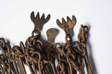
Instrument - Gunter Chain, not known
... It enabled plots of land to be accurately surveyed and plotted, for legal and commercial purposes. ...It enabled plots of land to be accurately surveyed and plotted, for legal and commercial purposes. ...Gunter's chain (also known as Gunter’s measurement) is a distance measuring device used for surveying. It was designed and introduced in 1620 by English clergyman and mathematician Edmund Gunter (1581–1626). It enabled plots of land to be accurately surveyed and plotted, for legal and commercial purposes. The provenance of this particular Gunter Chain is unknown but it is believed to be used either by the City of Bendigo / Sandhurst or the Lands Department locally when measuring and laying out plots and streets locally. A 66-foot (20.1 m) chain divided into 100 links, marked off into groups of 10 by brass rings or tags. Each link is 7.92 inches (201 mm) long. A quarter chain, or 25 links, measures 16 feet 6 inches (5.03 m) also called a a rod (or pole) measure. Ten chains measure a furlong and 80 chains measure a statute mile. city of greater bendigo surveying -
 Bendigo Military Museum
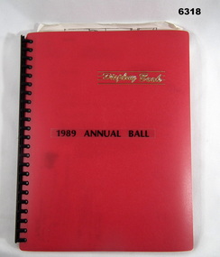
Administrative record - Army Survey Regiment Officers Mess Ball 1989, Army Survey Regiment, 25 Feb 1989
... Army Survey Regiment Officers Mess Ball 1989...The Army Survey Regiment held Annual Balls at Fortuna Villa. ...Army Survey Regiment...Royal Australian Survey Corps RASvy Fortuna Army Survey Regiment Army Svy Regt ASR A4 Plastic bound Red Display Folder containing documentation for the 1989 Annual Ball, Letters, signals and photos Army Survey Regiment Officers Mess Ball 1989 Administrative record Army Survey Regiment Officers Mess Ball 1989 Army Survey Regiment ...The Army Survey Regiment held Annual Balls at Fortuna Villa. This folder contains the documentation for the Logistics and activities associated with the planning and running of the Ball in 1989.A4 Plastic bound Red Display Folder containing documentation for the 1989 Annual Ball, Letters, signals and photosroyal australian survey corps, rasvy, fortuna, army survey regiment, army svy regt, asr -
 Bendigo Military Museum
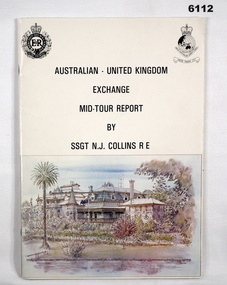
administrative record - Australian - United Kingdom Exchange Mid Tour Report by SSGT NJ Collins RE 1987, SSGT N.J. Collins RE, 29. 03.1987
... Collins RE, a British Army Senior NCO on a two-year exchange to the Army Survey Regiment. ......Army Survey Regiment...Collins RE, a British Army Senior NCO on a two-year exchange to the Army Survey Regiment. Royal Australian Survey Corps RASvy Fortuna Army Survey Regiment Army Svy Regt ASR Green Hi-Light on parts of pages 10 and 11. ...The document is the Mid Tour Report by SSGT N.J. Collins RE, a British Army Senior NCO on a two-year exchange to the Army Survey Regiment. A4 size, Stapled, Front cover has a reproduction of a painting of Fortuna Villa in bottom half. Back cover has a difficult to see street scene of Pall Mall, Bendigo with a paragraph describing Bendigo's history superimposed. 19 Pages. The actual Report is contained on Pages 1-16. Annex A is 2 x pages plus a contents page.Green Hi-Light on parts of pages 10 and 11.royal australian survey corps, rasvy, fortuna, army survey regiment, army svy regt, asr -
 Bendigo Military Museum
Album - PHOTOGRAPH ALBUM, WWII
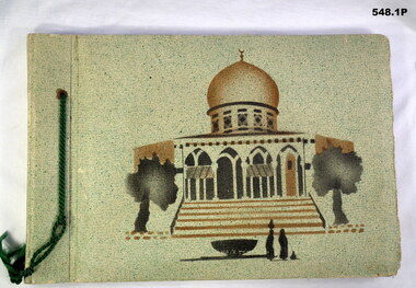
... The album collection belonged to Jack Smethurst VX28896 Australian Army Survey Regiment (Royal Australian Artillery). ...Bendigo Military Museum 37 - 39 Pall Mall Bendigo goldfields The album collection belonged to Jack Smethurst VX28896 Australian Army Survey Regiment (Royal Australian Artillery). ...The album collection belonged to Jack Smethurst VX28896 Australian Army Survey Regiment (Royal Australian Artillery). Refer 549.4, 550.2, 557, 558.6.548.1P. Green front, picture of mosque, photos of Syria. Green cord on side. MIxture of B&W photos and small postcards. Four loose B&W photos inside front cover. 548.2P. Black cover, silver inlay of David's Tower. Brown cord on spine. Tourist and Australian Army B&W photos. Six loose B&W photos between first and second pages. 548.3P. Black cover, silver inlay of Rachael's Tomb. Brown cord on spine. Two loose photos on back pages. Tourist and Army photos of Libya, Palestine and Syria.books-albums, photography-photographs, middle east, military history, royal australian artillery -
 Bendigo Military Museum
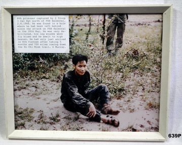
Photograph - PHOTOGRAPH VIETNAM, FRAMED, 2/6/68
... Photo in collection re Geoff Murray No 3411521, Vietnam 3 Cav Regt 27.11.67 to 22.10.68, Survey Corp 15.10.69 to 15.10.70. Refer 638P....Bendigo Military Museum 37 - 39 Pall Mall Bendigo goldfields Photo in collection re Geoff Murray No 3411521, Vietnam 3 Cav Regt 27.11.67 to 22.10.68, Survey Corp 15.10.69 to 15.10.70. Refer 638P. ...Photo in collection re Geoff Murray No 3411521, Vietnam 3 Cav Regt 27.11.67 to 22.10.68, Survey Corp 15.10.69 to 15.10.70. Refer 638P.Colour photo, Vietnam showing a captured NVA soldier sitting on the ground. Attached label gives details of time and place. Frame is cream painted wood.vietnam, viet cong, fsb balmoral -
 Bendigo Military Museum
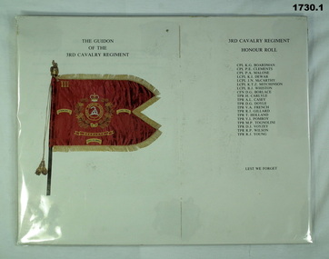
Souvenir - DOCUMENTS 3 CAV REGT, 14.5.1986
... Items relate to Geoff Murray No 3411521, Vietnam 3 Cav Regt 27.11.67 to 22.10.68, Survey Corp 15.10.69 to 15.10.70. Refer Cat No 638P...Bendigo Military Museum 37 - 39 Pall Mall Bendigo goldfields Items relate to Geoff Murray No 3411521, Vietnam 3 Cav Regt 27.11.67 to 22.10.68, Survey Corp 15.10.69 to 15.10.70. Refer Cat No 638P documents military history-army 3 CAV Regt guidions .2) "Wed 14 May 1986" .1) Document showing the Guidion of the 3rd Cavalry Regiment and that unit's honour roll Vietnam. .2) Document relating to the presentation of the 3rd/4th Cavalry Regiment's Guidion at Ennogerra Barracks QLD by the Duke of Edinburgh Prince Phillip. ...Items relate to Geoff Murray No 3411521, Vietnam 3 Cav Regt 27.11.67 to 22.10.68, Survey Corp 15.10.69 to 15.10.70. Refer Cat No 638P.1) Document showing the Guidion of the 3rd Cavalry Regiment and that unit's honour roll Vietnam. .2) Document relating to the presentation of the 3rd/4th Cavalry Regiment's Guidion at Ennogerra Barracks QLD by the Duke of Edinburgh Prince Phillip. .2) "Wed 14 May 1986"documents, military history-army, 3 cav regt, guidions -
![Book - Article, Fiona Weaver, Lower Plenty River Archaeological Survey by Fiona Weaver [excerpt], 1991](/media/collectors/62fc2e8d3b4c83fe7f279a1c/items/6450d73a49371722cf4f2ee8/item-media/6450d9b949371722cf4f5830/item-fit-380x285.jpg?cb=6) Heidelberg Golf Club
Heidelberg Golf ClubBook - Article, Fiona Weaver, Lower Plenty River Archaeological Survey by Fiona Weaver [excerpt], 1991
... Lower Plenty River Archaeological Survey by Fiona Weaver [excerpt]...Excerpt from Lower Plenty River Archaeological Survey by Fiona Weaver. Section 5 on Aboriginal archaeological sites in the Lower Plenty River area....A survey of First Nations sites in the Lower Plenty River area. ...Excerpt from Lower Plenty River Archaeological Survey by Fiona Weaver. Section 5 on Aboriginal archaeological sites in the Lower Plenty River area.A survey of First Nations sites in the Lower Plenty River area.Copy of part of book.lower plenty river, aboriginal sites -
Creswick Campus Historical Collection - University of Melbourne
Maps, 1967 - 1972
... Barmah Forest 1967. Survey maps from aerial photography 1971 _Narnargoon.Tonimbuk. ...Barmah Forest 1967. Survey maps from aerial photography 1971 _Narnargoon.Tonimbuk. ...Maps of various subjects: Gunbower Island 1972. Barmah Forest 1967. Survey maps from aerial photography 1971 _Narnargoon.Tonimbuk. Gilwell & Beenak.Maps -
 Mont De Lancey
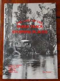
Book, Ann Thomas, The Last of the Yarra Track Stopping Places, September 1980
... The Gold Rush Route: Surveyed and cut in the 1860s, the Yarra Track served as a vital, treacherous lifeline connecting Melbourne to the isolated goldfields of Woods Point....The Gold Rush Route: Surveyed and cut in the 1860s, the Yarra Track served as a vital, treacherous lifeline connecting Melbourne to the isolated goldfields of Woods Point. ...This book is a renowned 1980 pictorial history book by local historian Ann Thomas. It documents the historic 1860s gold-rush route stretching from Yarra Glen through Marysville to Woods Point, detailing the remote bush settlements, stores, and hotels that supported prospectors.A large paperback book with a black and and white photograph of a covered wagon drawn by two horses crossing a flooded track in the bush. The horses are drinking from the creek. The title is printed in red lettering with the author's name at the bottom. There is a small price sticker at the top right hand corner. Publishing details are on the back of the title page. There are Contents and Acknowledgements pages. The old Yarra Track was the trail of the early gold seekers followed for the latter four decades of the 19th century. Pp. 56.non-fiction This book is a renowned 1980 pictorial history book by local historian Ann Thomas. It documents the historic 1860s gold-rush route stretching from Yarra Glen through Marysville to Woods Point, detailing the remote bush settlements, stores, and hotels that supported prospectors.goldfields - victoria, yarra track - history, marysville - victoria -
 Bendigo Military Museum
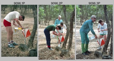
Photograph - Army Inter-area Orienteering Competition, Kimbolton State Forest, VIC, 1990
... Teams from Albury-Wodonga Bendigo, Broadmeadows, Melbourne Metropolitan, Puckapunyal and Watsonia participated in the annual competition. Bendigo’s Army Survey Regiment led by SGT Mick Minchin hosted the Orienteering events. ...They are part of the Army Survey Regiment’s Collection. .1) to .4) - Photo, colour, 1990, unidentified competitors. .5) - Photo, colour, 1990, L to R: unidentified competitor, Bendigo’s Janet Murray. .6) - Photo, colour, 1990, L to R: unidentified official, Le-Anne (Smallshaw) Shirley, Bendigo’s Janet Murray, unidentified competitors (x2). .7) to .8) - Photo, colour, 1990, unidentified competitors. .9) - Photo, colour, 1990, L to R: unidentified official, Mick Minchin. .10) to .11) - Photo, colour, 1990, Mick Minchin. .12) to .13) - Photo, colour, 1990, Bendigo’s Team L to R: Rene van den Tol, Wolfgang Hofbauer, Mick Minchin, Harris Lee, unidentified competitor, Allan Blake, Janet Murray. .14) & .15) - Photo, colour, 1990, presentations L to R: Rene van den Tol, unidentified competitor. .16) to .19) - Photo, colour, 1990, unidentified competitors. .20) - Photo, colour, 1990, presentations L to R: Rene van den Tol, unidentified competitor. .21) - Photo, colour, 1990, presentations L to R: Rene van den Tol, unidentified competitor, Mick Minchin. .22) - Photo, colour, 1990, BBQ L to R: unidentified (x2), Jeff Rudd, Rene van den Tol, Mick Minchin, Neville Stone, Steve Cooper. .23) - Photo, colour, 1990, BBQ, Wolfgang Hofbauer. .24) - Photo, colour, 1990, BBQ, Janet Murray - in black jacket. .25) - Photo, colour, 1990, BBQ, all unidentified. .26) - Photo, colour, 1990, BBQ, Neville Stone - in green t-shirt, Rene van den Tol in red track suit, remainder unidentified. .27) - Photo, colour, 1990, BBQ L to R: unidentified (x4), Janet Murray, Le-Anne (Smallshaw) Shirley, remainder unidentified. .28) & .29) - Photo, colour, 1990, views of Lake Eppalock....Army Survey Regiment...Royal Australian Survey Corps RASvy Army Survey Regiment Army Svy Regt Fortuna There are no personnel identified. ...This set of 29 photographs was taken during Army’s Inter-area Orienteering competition held in the Kimbolton State Forest, near Lake Eppalock, Victoria in 1990. Teams from Albury-Wodonga Bendigo, Broadmeadows, Melbourne Metropolitan, Puckapunyal and Watsonia participated in the annual competition. Bendigo’s Army Survey Regiment led by SGT Mick Minchin hosted the Orienteering events. This set of 29 photographs was taken during Army’s Inter-area Orienteering competition held in Kimbolton State Forest, near Lake Eppalock, Victoria in 1990. The colour photographs are on 35mm negative film and were scanned at 2400 dpi. They are part of the Army Survey Regiment’s Collection. .1) to .4) - Photo, colour, 1990, unidentified competitors. .5) - Photo, colour, 1990, L to R: unidentified competitor, Bendigo’s Janet Murray. .6) - Photo, colour, 1990, L to R: unidentified official, Le-Anne (Smallshaw) Shirley, Bendigo’s Janet Murray, unidentified competitors (x2). .7) to .8) - Photo, colour, 1990, unidentified competitors. .9) - Photo, colour, 1990, L to R: unidentified official, Mick Minchin. .10) to .11) - Photo, colour, 1990, Mick Minchin. .12) to .13) - Photo, colour, 1990, Bendigo’s Team L to R: Rene van den Tol, Wolfgang Hofbauer, Mick Minchin, Harris Lee, unidentified competitor, Allan Blake, Janet Murray. .14) & .15) - Photo, colour, 1990, presentations L to R: Rene van den Tol, unidentified competitor. .16) to .19) - Photo, colour, 1990, unidentified competitors. .20) - Photo, colour, 1990, presentations L to R: Rene van den Tol, unidentified competitor. .21) - Photo, colour, 1990, presentations L to R: Rene van den Tol, unidentified competitor, Mick Minchin. .22) - Photo, colour, 1990, BBQ L to R: unidentified (x2), Jeff Rudd, Rene van den Tol, Mick Minchin, Neville Stone, Steve Cooper. .23) - Photo, colour, 1990, BBQ, Wolfgang Hofbauer. .24) - Photo, colour, 1990, BBQ, Janet Murray - in black jacket. .25) - Photo, colour, 1990, BBQ, all unidentified. .26) - Photo, colour, 1990, BBQ, Neville Stone - in green t-shirt, Rene van den Tol in red track suit, remainder unidentified. .27) - Photo, colour, 1990, BBQ L to R: unidentified (x4), Janet Murray, Le-Anne (Smallshaw) Shirley, remainder unidentified. .28) & .29) - Photo, colour, 1990, views of Lake Eppalock.There are no personnel identified. ‘Inter-Area Orienteering 1990’ annotated on negative sleevesroyal australian survey corps, rasvy, army survey regiment, army svy regt, fortuna -
 Bendigo Military Museum
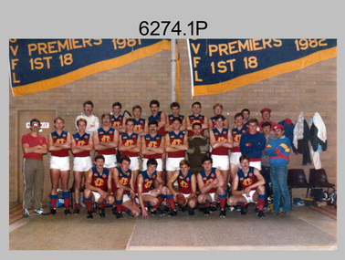
Photograph - Army Survey Regiment’s Fortuna Lions Football Club Grand Finals, Seymour, Victoria, 1983
... Army Survey Regiment’s Fortuna Lions Football Club Grand Finals, Seymour, Victoria....This is a set of seven colour and black and white photographs of Army Survey Regiment’s Australian Rules football team – the Fortuna Lions aka “Fortuna Fumblers”, taken at Seymour and Bendigo Victoria in 1983. ...This is a set of seven photographs of Army Survey Regiment’s Australian Rules football team – the Fortuna Lions aka “Fortuna Fumblers”, taken at Seymour Victoria in 1983. ...Army Survey Regiment...Army Survey Regiment ...This is a set of seven colour and black and white photographs of Army Survey Regiment’s Australian Rules football team – the Fortuna Lions aka “Fortuna Fumblers”, taken at Seymour and Bendigo Victoria in 1983. The Fortuna Lions competed in the Puckapunyal Area Football Association for several years from 1978 to 1984 and in 1983, fielded a great team it managed to reach the Grand Final. Held at the neutral ground at Kings Park, Seymour, the match was an incredibly exciting and bruising contest played in damp conditions and ended in a draw. Dave Lawler’s spectacular mark was a highlight. Due to heavy rain during the following week, the Grand Final replay was held the following week in even heavier conditions. The Fortuna Lions prevailed in the replay with an emphatic victory. The team’s leaders were Eddie Jacobs (coach), Rhys De Laine (captain), Greg Else (vice-captain), and Ken Slater (manager). Refer to items 6244.27P (black & white) and 6245.26P (colour) for other photographs taken at the two grand finals.This is a set of seven photographs of Army Survey Regiment’s Australian Rules football team – the Fortuna Lions aka “Fortuna Fumblers”, taken at Seymour Victoria in 1983. The photographs were printed on photographic paper and are part of the Army Survey Regiment’s Collection. The photographs were scanned at 300 dpi. .1) - Photo, colour. 1983. Fortuna Lions Football Team - Back row L to R: Don Mawson, Stuart Ridge, Alan Staley, Doug Home, Dave Lawler, Greg Byers, Glenn Cannon, Keith Quinton, Mick ‘Buddha’ Ellis. Middle row L to R: Brian Paul, Dennis Learmonth, Greg Higgins, Jim Ash, Larry Thompson, Rhys De Laine, Eddy Jacobs, Ken Slater, Bob Thrower, Andy Godden, Nick Van Dalen, Peter Colwell, Warren ‘Wah’ Hall. Front row L to R: Mick Hogan, Rod Skidmore, Terry McIntyre, Greg Else, Terry Winzar, Peter Jones. .2) - Photo, colour. 1983. Fortuna Lions Football Team Grand Final Banner. .3) - Photo, colour. 1983. L to R: Kristin (Isaac) Skidmore, Santina (Argetto) Straube, Stuart Ridge, Nick Van Dalen, Larry Thompson, Jim Ash, Carmel (Butler) Fauth, Gayle Humphrey. .4) - Photo, black and white. 1983. Jim Ash in celebration. .5) - Photo, black and white. 1983. L to R: unidentified, Brian Fauth, Glenn Cannon. .6) - Photo, black and white. 1983. L to R: Doug Home, back of Warren ‘Wah’ Hall, Terry Winzar with premiership cup. .7) - Photo, black and white. 1983. Larry Thompson with premiership cup..1P to .7P – there are no annotations.royal australian survey corps, rasvy, army survey regiment, army svy regt, fortuna, asr -
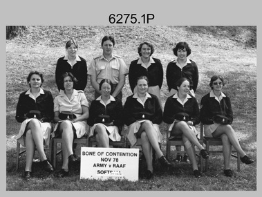 Bendigo Military Museum
Photograph - Bones Day - Army Survey Regiment Versus RAAF School of Radio. Fortuna, Bendigo, 1978
... Bones Day - Army Survey Regiment Versus RAAF School of Radio. ...These eight photographs were taken at Bones Day, an annual sports competition between the Army Survey Regiment and the RAAF School of Radio at Bendigo in November 1978. ...These eight photographs were taken at Bones Day, an annual sports competition between the Army Survey Regiment and the RAAF School of Radio at Bendigo in November 1978. ...Army Survey Regiment...Fortuna, Bendigo. Army Survey Regiment ...These eight photographs were taken at Bones Day, an annual sports competition between the Army Survey Regiment and the RAAF School of Radio at Bendigo in November 1978. The two units took turns each year to host the event. The day competition usually comprised basketball, cross country, golf, sailing, squash, softball, tennis, touch football, rifle shooting, tug-of-war and volleyball. The “big bone” trophy comprising a large bone from a beast housed inside a wooden framed glass case, was awarded to the winner of the day competition. The evening competition often included darts, carpet bowls, hookey, quoits and billiards/snooker. The “little bone” (a mounted chicken bone) was the consolation trophy awarded to the winner of the evening competition. The 3-hour bus trip for the visiting unit on their return was typically very raucous. The history of the Bones Day competition is best described in the booklet titled - Bones of Contention Souvenir Program. 1965. Refer to Item 6267. See item 9001.31P for more photographs taken on this occasion.These eight photographs were taken at Bones Day, an annual sports competition between the Army Survey Regiment and the RAAF School of Radio at Bendigo in November 1978. The photographs were printed on photographic paper and are part of the Army Survey Regiment’s Collection. The photographs were scanned at 300 dpi. .1) - Photo, black & white, 1978, Softball Team Back Row L to R: Janet (Chopping) Justin, John Ashby, Scheryal Delforce, Tracey (Beckwith) Phillips. Front Row L to R: Zoe (Lisiewich) Ames, Di Chalmers, unidentified, Le-Anne (Smallshaw) Shirley, Lorraine (Daly) Talbot-Smith, Lynn Johnson. .2) - Photo, black & white, 1978, Tennis Team Back Row L to R: Mick Flynn, Chris Carter, Ken Delmenico. Front Row L to R: unidentified (x3), Adrian Rynberk. .3) - Photo, black & white, 1978, Golf Team Back Row L to R: George Austen, unidentified, Roger Rees. Front Row L to R: Peter Imeson, Greg Gilbert, unidentified officer, Paul Richards. .4) - Photo, black & white, 1978, Basketball action: Gill Park – No. 8 .5) - Photo, black & white, 1978, evening events: L to R: Garry Hudson, unidentified RAAF airwoman. .6) - Photo, black & white, 1978, evening events: L to R: Gary Warnest, Wayne Rothwell. .7) - Photo, black & white, 1978, evening events: L to R: Mick ‘Buddha’ Ellis, unidentified RAAF airwoman. .8) - Photo, black & white, 1978, evening events: L to R: Mick ‘Buddha’ Ellis, unidentified, Ian Belmont, Ken Slater. .1P to .8P – No personnel are annotated.royal australian survey corps, army svy regt, rasvy, army survey regiment, fortuna, asr, raaf school of radio, bones day -
 Bendigo Military Museum
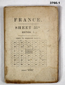
Map - MAPS, FRANCE WW1, 1915 - 1917
... (.1) Map, France, sheet 51A, Edition 1, scale 1:40,000, Ordnance survey 1916, gauze lined, rear has glossary of terms French to English. (.2) Map, France, sheet 62B, first edition, scale 1:40,000, Ordnance survey December 1917, gauze lined, rear has glossary of terms French to English. (.3) Map France, Lens 11, scale 1:100,000, OSO 1915, gauze lined. (.4) map, France, Dieppe 16, scale 1:100,000, general staff No 2364, War Office 19– gauze lined. (.5) Map, France (same as (.2)...Maps France (.2 & .5) On rear hand written “124 A.L.T.M.B P179/5 (.1) Map, France, sheet 51A, Edition 1, scale 1:40,000, Ordnance survey 1916, gauze lined, rear has glossary of terms French to English. (.2) Map, France, sheet 62B, first edition, scale 1:40,000, Ordnance survey December 1917, gauze lined, rear has glossary of terms French to English. (.3) Map France, Lens 11, scale 1:100,000, OSO 1915, gauze lined. (.4) map, France, Dieppe 16, scale 1:100,000, general staff No 2364, War Office 19– gauze lined. (.5) Map, France (same as (.2) Map MAPS, FRANCE WW1 ...(.1) Areas covered by this map, Somain to Valenciennes, Ramillies to Beaudignies. (.2) Areas covered on this map, Bellicourt to Tupigny, St Quentin to Guise. (.3) Areas covered on this map, Heslin to lens, Domart to Baupaume. (.4) Areas covered on this map, Dieppe to Le Quesnoy, Monville to Bonniers. (.5) Same as (.2) Items relate to William Alexander No 502 AIF. Refer 3746.3 for his service details.(.1) Map, France, sheet 51A, Edition 1, scale 1:40,000, Ordnance survey 1916, gauze lined, rear has glossary of terms French to English. (.2) Map, France, sheet 62B, first edition, scale 1:40,000, Ordnance survey December 1917, gauze lined, rear has glossary of terms French to English. (.3) Map France, Lens 11, scale 1:100,000, OSO 1915, gauze lined. (.4) map, France, Dieppe 16, scale 1:100,000, general staff No 2364, War Office 19– gauze lined. (.5) Map, France (same as (.2)(.2 & .5) On rear hand written “124 A.L.T.M.B P179/5maps, france -
 Bendigo Military Museum
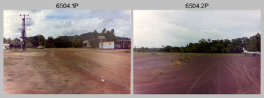
Photograph - 4th Field Survey Squadron – Operation NERVOSE 85 Reconnaissance, Northern Territory, 1985
... 4th Field Survey Squadron – Operation NERVOSE 85 Reconnaissance, Northern Territory...This is a set of 13 photographs taken during 4th Field Survey Squadron’s reconnaissance of Operation NERVOSE 85 locations in the Northern Territory in 1985. ...Army Survey Regiment...Vickers RE - UK Exchange Officer from Army Svy Regt, unidentified officer. 4th Field Survey Squadron – Operation NERVOSE 85 Reconnaissance, Northern Territory Photograph 4th Field Survey Squadron – Operation NERVOSE 85 Reconnaissance, Northern Territory Army Survey Regiment ...This is a set of 13 photographs taken in 1985* during reconnaissance of locations in regions of the Northern Territory. Later that year, Operation NERVOSE 85 was mounted by 4 Fd Svy Sqn in the EAST ARNHEM, VICTORIA RIVER DOWNS AND DALY WATERS areas of the Northern Territory from 26 May to 18 Sep 85. The aim of Operation NERVOSE 85 was to finalise the horizontal and vertical control for mapping at a scale of 1:50,000, to field check 40x 1:50,000 preliminary maps and to obtain mapping photography in support of the RAAF TINDAL redevelopment project. *Note –These photos were most likely taken in 1985, contrary to the ‘1987’ date annotated on the negative sleeves. The Op NERVOSE 85 Project Report available on RASVY’s web site lists a nominal roll of personnel. Photos of 4 Fd Svy Sqn taken in 1985 and 1987 provide names of posted personnel. Several personnel identified in these photos were posted to 4 Fd Svy Sqn in 1985, not in 1987.This is a set of 13 photographs taken during 4th Field Survey Squadron’s reconnaissance of Operation NERVOSE 85 locations in the Northern Territory in 1985. The colour photographs are on 35mm negative film and are part of the Army Survey Regiment’s Collection. The photographs were scanned at 96 dpi. .1) to .4) - Photo, colour, 1985. Unknown location in the Northern Territory. .5) - Photo, colour, 1985. Unidentified personnel in the back of a police vehicle. .6P to .12) - Photo, colour, 1985. Unknown location in the Northern Territory. .13) - Photo, colour, 1985. L to R: Possibly MAJ A. Vickers RE - UK Exchange Officer from Army Svy Regt, unidentified officer. .1P to .13P – There are no personnel identified. ‘1987 OP NERVOSE – RECON PHOTOG.’ annotated on negative sleeve.royal australian survey corps, rasvy, 4 fd svy sqn, op nervose 85 -
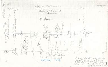 Ringwood and District Historical Society
Document - Copy of Lands Department Field Notes - Parish of Ringwood, Victoria, Field Notes 88-9/276 - Part of O.P. R72C surveyed 12.10.1888
... Foolscap size photocopy of survey map with handwritten notations. References include - Commencing at bank of creek, Bearing over fence read 134"12', post and rail fence, old round post, Quigley, WB house iron roof, paling & shingle roof, garden, Forshaw formerly Hoare, D Brown, stable & shed, slats & palings, orchard, Occupied by Forshaw, 4 rooms WB Cottage iron roof, Sherbin, Old three chain road, Maroondah Highway, Molloy's corner, I certify that this survey has been effected in accordance with the regulations and that this is a correct copy of my results (signed) - Reed, Assistant Surveyor, 12.10.88....Field Notes 88-9/276 - Part of O.P. R72C surveyed 12.10.1888 Document Copy of Lands Department Field Notes - Parish of Ringwood, Victoria ...Foolscap size photocopy of survey map with handwritten notations. References include - Commencing at bank of creek, Bearing over fence read 134"12', post and rail fence, old round post, Quigley, WB house iron roof, paling & shingle roof, garden, Forshaw formerly Hoare, D Brown, stable & shed, slats & palings, orchard, Occupied by Forshaw, 4 rooms WB Cottage iron roof, Sherbin, Old three chain road, Maroondah Highway, Molloy's corner, I certify that this survey has been effected in accordance with the regulations and that this is a correct copy of my results (signed) - Reed, Assistant Surveyor, 12.10.88.