Showing 7038 items matching "historic"
-
 Kew Historical Society Inc
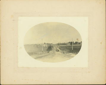
Photograph - Riversdale Road, Surrey Hills, E.J. Dower, c.1915
Contextual or historic information One of a series of photographs, taken by Edgar James Dower in the second decade of the twentieth century. Born and raised in Olinda, his family later moved to Surrey Hills. He worked as an adult as a clerk in the city office of the Metropolitan Gas Company, and in his role as a 'collector', he was able to photograph scenes including the construction of tramlines and associated buildings in Kew, Hawthorn, Camberwell and Surrey Hills. Later he established a real estate agency with his brother - the E.J. Dower Real Estate Agency, Dandenong Office.The image is an historically significant record of the development of transport infrastructure which was used to connect Victorians in the first two decades of the twentieth century. This development resulted from increases in population and the consequent extension of Melbourne's suburbs. The photographs, both individually and collectively, richly detail the labour of workers and the tools and machinery used to create and extend Melbourne's tram network in the years preceding and during World War 1.Digital copy of an original oval mounted photograph depicting Riversdale Road, Surrey Hills, before the construction of the proposed electric tramline.Annotated verso: "Riversdale Road Surrey Hills / Preparing for electric tram line / Note Essex Road on right with picket fencing."theme --- travelling by tram, theme -- connecting victorians by transport and communications, riversdale road -- surrey hills, tramlines -- surrey hills -
![Royal Australian Nursing Federation campaign badge, [1986?]](/media/collectors/5bb42dc221eaf31100db1d3b/items/5c46910f21ea690150ee2352/item-media/5c4693cb21ea690150f1a10a/item-fit-380x285.jpg) Australian Nursing & Midwifery Federation
Australian Nursing & Midwifery FederationRoyal Australian Nursing Federation campaign badge, [1986?]
Distributed to nurses during campaigning for improved wages and working conditions in the 1980s, possibly during the historic 1986 Victorian 50-day nurses strike. The title for a 'Grade 1' nurse is now a 'Division 1' or (more commonly) 'Registered Nurse'. The Royal Australian Nursing Federation (RANF) became the Australian Nursing Federation in 1989, suggesting that this button is from the late 1980s. Similar to the badges worn in this photo [https://stories.anmfvic.asn.au/86strike/media/2560-1440-landscape-sec2-contentb-hr_logwf7a.jpg] from 1986 (see individual on the far right).Circular blue and white plastic button. Silver metal, plastic-coated, with safety pin fastener adhered to back. Button printed with 'Don't ask me, I'm a Grade 1 nurse' and 'R.A.N.F. [Royal Australian Nursing Federation] Vic. [Victorian] Branch'.nursing, industrial action, nurses, strike action, unionism, badges, buttons, pins, campaigning, 1986 victorian nurses strike, trade unions, labour history -
![Royal Australian Nursing Federation campaign badge, [1986?]](/media/collectors/5bb42dc221eaf31100db1d3b/items/5c46a72a21ea6901500b233d/item-media/5c46a73a21ea6901500b3766/item-fit-380x285.jpg) Australian Nursing & Midwifery Federation
Australian Nursing & Midwifery FederationRoyal Australian Nursing Federation campaign badge, [1986?]
Distributed to nurses during campaigning for improved wages and working conditions in the 1980s, possibly during the historic 1986 Victorian 50-day nurses strike. The title for a 'Grade 1' nurse is now a 'Division 1' or (more commonly) 'Registered Nurse'. The Royal Australian Nursing Federation (RANF) became the Australian Nursing Federation in 1989, suggesting that this button is from the late 1980s. Similar to the badges worn in this photo [https://stories.anmfvic.asn.au/86strike/media/2560-1440-landscape-sec2-contentb-hr_logwf7a.jpg] from 1986 (see individual on the far right).Circular white and blue plastic badge. Silver metal, plastic-coated, with safety pin fastener adhered to back. Badge printed with 'Don't ask me, I'm a Grade 1 nurse' and 'R.A.N.F. [Royal Australian Nursing Federation] Vic. [Victorian] Branch'.nursing, nurses, industrial action, strike action, unionism, badges, buttons, pins, campaigning, 1986 victorian nurses strike, trade unions, labour history, royal australian nursing federation -
 Tarnagulla History Archive
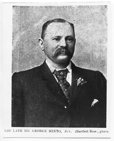
Photograph: copy of news image of George Minto, c. 1870s
Murray Comrie Collection. George Minto (b.1824 in Harwick, Scotland) was engineer at the Flour Mill in Tarnagulla, was Mayor of Tarnagulla Borough Council for a time and was engineer of the Shire of Marong for twenty years. For 13 years he occupied the position of surveyor to the Bendigo City Council. In his later life he lived in Kangaroo Flat. Whilst living there, on the 28th November 1914, he died, aged 90 and a half years. This photograph is a reasonable image created from a historic news source (unknown). Copy probably made by Murray Comrie in the 1970s.Monochrome photograph, being copy of a news clipping with image of George Minto. Printed caption 'The Late Mr. George Minto, Jun. (Bartlett Bros, photo)'. tarnagulla, people -
 Parks Victoria - Gabo Island Lightstation
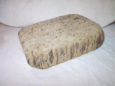
Cork fragments
From accompanying interpretive sign,"Early life jackets and life- rings were made using cork for bouyancy. A poignant reminder of the risks facing seafarers". Triangular and rectangular pieces of cork are from old life jackets. Curved piece with canvas remnant and white paint is a section of an old life ring. The piece with hole and split is a float off a fishing net. As cork is also used to provide buoyancy to fishing nets, further information on these fragments, such as their degree of rarity, and the historic use of cork for buoyancy in relation to lightstations and rescue equipment would be helpful. They will have second level contributory significance if it can be established that they are historically associated with the functions of the lightstation. 1. Triangular shaped piece of cork, has holes and cracks. 2. Rectangular shaped piece of cork, has large holes through piece. Remains of white textile covering on two sides (long sides). Piece is slightly convex. 3. Rectangular pieceof cork. Corners are rounded . Rough pitted surface. 4. Tube shaped section of cork. Has hole through middle with split in one side extending to hole. Around outside there are even lines extending horizontally. -
 Wodonga & District Historical Society Inc
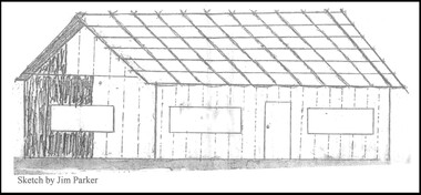
Drawing - The Green Hills School
Green Hills School was the first school in the Wodonga area. Before the school could open and a teacher commence duties, the Government had to be assured that a minimum of 20 children would be attending. The school was built of round timber, slab walls, bark roof, dirt floor and shuttered windows. The school opened in 1850 and closed in 1870. This sketch, completed by Jim Parker, a Life Member of Wodonga & District Historical Society, was included on a commemorative plaque as part of the Wodonga Heritage Drive established by the Society to recognise the story of key historic locations in the Wodonga area.This drawing is significant because it depicts the first school opened in Wodonga.A sketch of Green Hills School completed by Jim Parker, a life member of Wodonga & District Historical Society. This sketch was completed as part of a project to place commemorative plaques at key locations around Wodonga green hills school, wodonga schools, education wodonga -
 Clunes Museum
Article - NEWSPAPER CUTTINGS
.1 The Messenger was the Journal of Social and Religious Progress - The official organ of the Presbyterian Church of Victoria and Tasmania. Volume XII (New Series) - No.38, March 17 1939 cost 3d Page 608, Letter to the Editor - "Correspondence Clunes" .2 Publication dated February 1948, Headline "Back to Committee in Action" .3 Publication dated Wednesday Dec 27 1967, Headline "Tourello Run - historic home of the McLennans, page 11 .4 Publication Headline "Clunes - Where I was Born" .5 Background information on the donation of the above cuttings and publication.1 "The Messenger" publication of the Presbyterian Church .2 Newspaper cutting from "Clunes Guardian & Gazette" .3 Newspaper cutting from "The Courier" .4 Newspaper cutting from "The Clunes - Talbot Guardian" .5 Card with photo of gum trees with a handwritten personal note to "Reg" from "M & M"samuel harris, oz harris, marshallsea, mclennan, back to clunes commitee1948 -
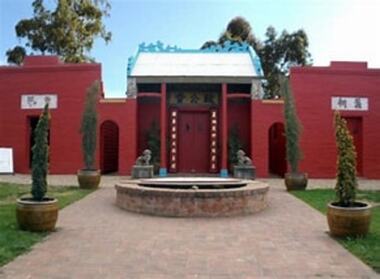 Bendigo Historical Society Inc.
Document - National Trust Collection: Bendigo Joss House, 1965 - 1985
Victorian Heritage Database - Bendigo Chinese Temple. https://vhd.heritagecouncil.vic.gov.au/places/34220/download-report The temple is one of few surviving buildings of its type in Victoria and stands as sole reminder of once extensive Chinese community that flocked to this area during the gold rush. Its symmetrical composition is dominated by ornamental central portico and reflects traditional Chinese design principles; the lantern in centre of interior wall painting in portico. Brick cresting and incised carving of head board are notable features. It is an outstanding feature of this historic city. (Australian Heritage Commission Citation).National Trust Collection: Bendigo Joss House A. Letter dated 1 June 1965 to Consul to the Republic of China requesting assistance with restoration of the Joss House. B. Letter dated 30.6.68 from June Adams reporting information supplied by P. Goon about the layout of the Joss House. C. Two letters ...joss house, preservation, national trust, p.goon -
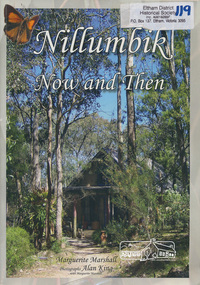 Eltham District Historical Society Inc
Book, Marguerite Marshall, Nillumbik now and then / Marguerite Marshall; photographs Alan King with Marguerite Marshall, 2008
Nillumbik Now and Then takes the reader on a journey from when the Aboriginal people were this area's sole inhabitnats, to the present day. Nillumbik's history - told in this collection of 96 stories, which are nearly all based on sites - mirrors those of the wider Australian community. It includes tales of the Wurundjeri people, a former convict, farmers, a bushranger, gold-mining, soldiers, artists, intellectuals, environmentalists and sportspeople. Each story is illustrated with a photograph. As a journalist with the former Diamond Valley News, Marguerite Marshall wrote a series of articles on local places of historic interest, later published as the small book "Eltham Shire - Historic Buildings and Places". Many years later an expanded version was published under the title "Nillumbik Now and Then". This is a much larger version of "Nillumbik Now and Then", including significant rewriting and many additional articles. The new publication was made possible by financial support from the Victorian Public Records Office, Bendigo Bank and Nillumbik Shire Council. EDHS and other historical societies in Nillumbik assisted with content for many of the stories. The book was launched at the Eltham Library on Wednesday 19th November 2008. Source: EDHS Newsletter No 183, November 2009 The front cover art depicts The former house of naturalist and artist Neil Douglas at Bend of Islands, photographer Marguerite Marshall. This collection of almost 130 photos and stories about places and people within the Shire of Nillumbik, an urban and rural municipality in Melbourne's north, contributes to an understanding of the history of the Shire. Published in 2008 immediately prior to the Black Saturday bushfires of February 7 2009, it documents sites that were impacted, and in some cases destroyed by the fires. It includes photographs taken especially for the publication, creating a unique time capsule representing the Shire in the early 21st century. It remains the most recent comprehenesive publication devoted to the Shire's history connecting local residents to the past. Paperback; x, 198 p. : ill., ports. ; 30 cm.Signed by the authornillumbik shire, houses, buildings, weller's hotel, landmarks, bend of islands -
Clunes Museum
Book, NATIONAL LIBRARY OF AUSTRALIA et al, CLUNES - A TOWNSCAPE STUDY OF A VICTORIAN COUNTRY TOWN
GENERALLY THIS SIDY IS AN ANALYSIS OF THE VISUAL FABRIC OF THE TOWN AND GIVES SUGGESTED GUIDELINES FOR FUTURE GROWTHBOOK - CLUNES - A TOWNSCAPE STUDY OF A VICTORIAN COUNTRY TOWN PRODUCED BY CENTRE FOR ENVIROMENTAL STUDIES. UNIVERSITY OF MELBOURNE 1977GENERALLY THIS SIDY IS AN ANALYSIS OF THE VISUAL FABRIC OF THE TOWN AND GIVES SUGGESTED GUIDELINES FOR FUTURE GROWTHlocal history, town scape -
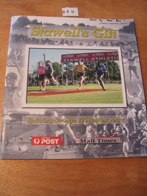 Stawell Historical Society Inc
Book, Wimmera Mail Times, Stawell's Gift, Sprinting through 125 Golden Years, 2002
Card Cover various with B/W Photos of the Stawell Gift, with a Colour Photograph of four runners finishing the Stawell gift.Stawell;s Gift Sprinting through 125 Golden Years Australia Post (In Logo) The Wimmera Mail Times (In Logo) On rear Cover To The Stawell Athletic Club Congratulations & Thank You Congratulations to the Stawell Athletic Club and all the volunteers and competitors who have contributed to the legend of the Australia Post Stawell Gift. This historic carnival has not only grown to become one of Australia's most prestigious sporting events, it makes a real contribution to the region's economy and spirit. We are proud to be part of your success. Happy 125th Anniversary from your partner. POST Principal Sponsor 1995 to 2002stawell athletic sport -
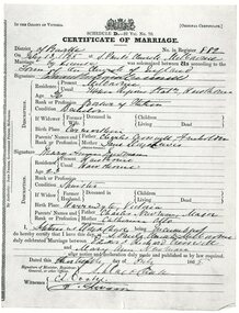 Ringwood and District Historical Society
Document, An excerpt of the account book from Charles Newman 1860-1893, including marriage certificate of Mary Ann Newman, daughter of Charles, to Edward Richard Crosswell
An excerpt of the account book from Charles Newman 1860-1893, including marriage certificate of Mary Ann Newman, daughter of Charles, to Edward Richard Crosswell on 13 July 1865 at St Paul’s Church, Melbourne. Major Charles Newman (1795-1866) had one of the first pastoral holdings east of Melbourne in the 1830s. It was located around the confluence of the Yarra River and the Mullum Mullum (or Deep) Creek. The family built the historic, and heritage-listed, Pontville Homestead, constructed in the 1840s and still there today. Caroline Madden, who married Nicholas Madden, one--time owner of the Coach & Horses Hotel, was the daughter of Edward Crosswell. -
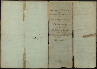 Federation University Historical Collection
Document, Statement of the Distribution and General Account Current of the Prize Money Granted to the British Army for the Battle of Waterloo and Capture of Paris in the Year 1815, 1815
The Napoleonic Wars were a period of conflict from 1803-1815, caused by unresolved tensions following the end of the French Revolution. Coalitions of European powers fought against Napoleon Bonaparte and the French army, who were defeated at the Battle of Waterloo on the 18th June 1815, in Belgium. The conclusion of the battle would mark a period of sustained peace for Europe, that would bring with it cultural and technological innovation. This document in illustrative of the prize money awarded to different groups of soldiers following the Capture of Paris, separated into different classes. The first class consisted of General Officers, the second of Field Officers and Colonels, the third of Captains, the fourth of Subalterns, the fifth of Serjeants and the sixth of Corporals, Drummers and Privates. The Commander in Chief of the Army also received £61, 178/3/ 5 1/2. In addition to the money given to these classes, which approximately totaled £486,246 / 18/ 1 3/4, a total of £30,000 was paid to the Bank of England and £7,204 / 16/ 7 1/4 was paid to the Chelsea Hospital, to a grand total of £558,940/ 12/ 3. This money given to the Chelsea Hospital was part of the Army Prize Money Act 1814 (54th Geo. 3 c. 86, 14th July 1814), which when passed through parliament entailed that any prize money unclaimed or forfeited would be paid to the Chelsea Hospital. The Royal Hospital Chelsea is a charitable institution which provides support to war veterans and has existed since the reign of Charles II. The document goes into further details of the payments made to specific regiments, who include members of the British cavalry and artillery, rifleman, staff corps and foreign soldiers enlisted to aid with the campaign. The award of prize money following battle was meant to serve as an incentive for aggression and victory, in addition to helping deter looting of the deceased possessions. A paper watermark '1810' on the handwritten document suggests it is an original, and therefore was probably in the possession of a battle participant, most likely of a higher rank. The provenance of the document is unknown but one possibility is through former Ballarat School of Mines staff member Hester Darby, whose parents were Ernest Darby and Leah Hynam. Her maternal line boasted a Battle of Waterloo veteran. A number of handwritten pages 48 cm. x 34.5 cm. (slightly larger than A3) which has been folded in half, and in half again. When attempts were made to tape the torn document together, one page was taped in the wrong order. The top of the third page aligns with the bottom of the fourth page, the top of the fourth page with the bottom of the third. Corrections to this have been made in the transcript. DESCRIPTION ON DISCOVERY: "BALLARAT - Copy of an historic document of prize money paid after the battle of Waterloo and capture of Paris in 1815 has been found among old papers at the Ballarat School of Mines. The full amount of prize money was stated at "£558,913 10/10." Scores of regiments had their shares varying probably, according to the numbers. The document will be retained in the School of Mines Museum, ... (Age, 21 March 1941)The paper has an 1810 watermark on the paper as well as a watermark for S&C Wise. duke of wellington, waterloo, battle of waterloo, napoleon, napoleon bonaparte, british army, paris, darby, veteran, 1815, prize money, waterloo verterans, hester darby -
 Bendigo Historical Society Inc.
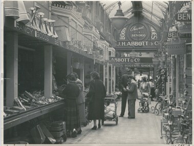
Photograph - BENDIGO ARCADE, c.1950
Black and white photograph of Abbott's in Bendigo Arcade, looking from Hargreaves St (now Mall) towards Pall Mall. Inscriptions in image: 'J H Abbot & Co, Boots, shoes, cheapest in Bendigo, Bennett's Arcade Stores, Fancy Goods' In margin at BRC 'V! 593.9'. Interesting photo showing fashions of the fifties and an idea of goods available through hardward and general merchants which would be similar to many others. Arcade ran from where 'Katies' are now in Pall Mall to Pall Mall (near the Beehive Building). On back: one third up on RHC in ink 'Bendigo Arcade, A Doney' Number 55 in top LHC History of object: Historic arcade opened c.1892. Demolished c.1960. Hargreaves Street end occupied by hardware and general merchant George Bennetts. Photograph Bendigo Advertiser 4.7.2000.Alan Doneyplace, arcade, bendigo arcade -
Kew Historical Society Inc
Archive (Sub-series) - Subject File, Kew Historical Society, Kew Association, 1974
Various partiesReference, Research, InformationSecondary valuesSubject file on ‘The Kew Association’ formed in 1974 as a separate group to the Kew Historical Society. Its constitution, which is filed, is general in nature. One part of the Association’s interests was the formation of a Historical Working Group to ‘examine historic buildings and other aspects of Kew’s history’. A founding member of the Society, Joy Stewart, was its convenor. By June 1974 it had 133 members. It differed from the Society in that it specifically aimed to improve Council services. One of its achievements was to begin a ‘historical home survey’ by street. The survey documents in the file list street name, number of house, side of street, size of house and general observations. Other information in the archive file includes correspondence, agendas, minutes etc. of the Association. As these only cover the years 1974-5, this may have been the period in which the group operated.kew - history, kew association - kew (vic), community groups - kew (vic), heritage - kew (vic)kew - history, kew association - kew (vic), community groups - kew (vic), heritage - kew (vic) -
Kew Historical Society Inc
Archive (Sub-series) - Subject File, Fernhurst (Kew), 1973
Various partiesReference, Research, InformationSecondary Values (KHS Imposed Order)Subject file containing research related to George Wharton and his house Fernhurst, originally situated on the corner of Princess Street and Studley Park Road, but later subdivided. The house was in the 20th century converted into flats and later bought by the Catholic Church, who established St Paul’s School for the Blind on the site. The situation was complicated as the Church also bought the neighbouring Neama and Mandalay. Villa Maria and St Paul’s School currently occupy the site. Part of the site was later subdivided to create Elphinstone Court. The file contains photocopied extracts from histories and detailed research and correspondence between the School, the Kew Historical Society, the National Trust of Victoria, and the Historic Buildings Preservation Council relating to both Neama and Fernhurst. There is a reference in a letter from St Paul’s inviting the Society to collect artefacts from the site. There are no known current items in the collection relating to the collection of these. kew (vic) - history, victorian architects - george wharton, fernhurst (kew), st paul’s school for the blindkew (vic) - history, victorian architects - george wharton, fernhurst (kew), st paul’s school for the blind -
 Bendigo Historical Society Inc.
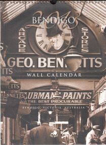
Ephemera - 2013 Bendigo wall calendar
2013 Bendigo wall calendar. 12-month calendar with historic image assigned to each month. January, Bennett's Arcade, 1950's; February, Bendigo Motor Garage, circa 1920; March, Fizelle & Mulqueen Undertakers horse-drawn hearse, circa 1890's; April, Bendigo Easter Fair, circa 1917; May, Bennett's Arcade, circa 1950's; June, Brian Boru Hotel, circa 1920's; July, Myers Flat 'Gold Rush', circa 1867; August, Bendigo Tramways Staff, circa 1910; September, Bendigo Post and Telegraph Office, circa 1888; October, Masonic Hall and Hotel, circa 1900; November, Friedrick & Bassemir Bakery, Bendigo, circa 1910; December, Shamrock Hotel, circa 1890's. Metal coil binding at the top of calendar. bendigo, calendar -
 Bendigo Historical Society Inc.
Document - NEW CHUM & VICTORIA LINES OF REEF - NEW CHUM & VICTORIA LETTER & NOTES
Handwritten letter to Mr. Blake with reference to meeting students and the changes in Bendigo. Mentioned are the Log Lock-Up, the Central Deborah Mine, the ex-manager of the mine, Mr. Rowe acting as a guide, Victoria Hill and the Bendigo Pottery. The notes titled ''To replace Around the Goldfields'' mentions the Third Edition, 'Historic Guide to Bendigo', published in 1969 of land reclamation schemes rapidly removing all traces of several mines. Those affected on the New Chum Line of Reef are: The Victoria Consols, Ironbark and Hercules and Energetic. The Sheepshead Line - the Ironbark and Ironbark South. On the Garden Gully Line - The Cornish United, Koch's Pioneer and Confidence Extended. The Paddy's gully Line - The British American, Lansell's Sandhurst (Needle) and the Collman and Tacchi. On the Derby Line - Johnson's No 3 (Nelson) and on the Hustlers Line are the United Hustlers and Redan and the K. K. Mines. Also, a carbon copy of the notes.document, memo, new chum & victoria letter & notes, mr blake, mr hattam, log lock-up, central deborah mine, mr rowe, victoria hill, bendigo pottery, historic guide to bendigo third edition, new chum line of reef, the victoria consols, ironbark, hercules and energetic, sheepshead line, ironbark, ironbark south, garden gully line, cornish united, koch's pioneer, confidence extended, paddy's gully line, the british american, lansell's sandhurst (needle), collman and tacchi. derby line, johmson's no 3 (nelson), hustlers line, united hustlers and redan, k k mines -
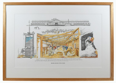 National Wool Museum
Print, Chris McClelland, Shearing the Rams – Tuppal Station, 210
Chris was invited to be artist in resident for the historic re-enactment of “Shearing the Rams” at the North Tuppal Station woolshed held on the 4th and 5th June 2010. The celebration attracted record crowds to witness the shearing of the station rams by 72 blade shearers. Over a single weekend in 2010, thousands of people queued for hours to see a piece of Australian history recreated at North Tuppal Station near Tocumwal, NSW. In 1900, Francis Faulkner invested a staggering £4000 to extend his shearing shed on Tuppal Station, making it the biggest in the country. Over the next decade more than three million sheep trod its pine boards and were shorn in its 72 stands. After years of drought and the Great Depression, the property fell into disrepair and the station was split up. When North Tuppal Station was sold to the Atkinson family in 1928, just five of the 72 stands were in operation. In 2010, Sport Shear Australia approached the Atkinson family about holding an event in the historic shearing shed to raise money for a team of Australian shearers to go to the world shearing title in Wales. An army of volunteers restored the T-shaped shed and yards and organised a weekend of events. Over two days, 6,000 sheep were shorn and all 72 stands of the restored North Tuppal shed were brought back to life. A total of 117 shearers shared the boards with 90 wool handlers who skirted 19 fleeces every minute. For a period on each day of this historic weekend, the machines were then silenced, and 72 shearers picked up their old blade shears to recreate past shearing methods. “When they fired up and got the blades out there was deathly silence on the board - you could hear a pin drop because normal shearing you have all the machines and it is quite noisy. Here you could just hear the click, like in the song Click Go the Shears Boys. People had tears in their eyes. It was quite an emotional thing to see that and very proud to be here.” George Falkiner, grandson of Francis FalkinerColoured framed print of shearing scene in the Tuppal station, Ferrrier’s wool press on the left-hand side and station on the top. Print in framed in a light-coloured wooden frame with white coloured matte.Under artwork - In 1891 Tuppal Station, a sum of 176,000 acres threshold, was bought by Mr Fiane Sadlies Falkines, Under the management of his eldest son F.B.S. Falkines, the 72 stand woolshed was build in 1900 and powered by a 16 horsepower steam engine. Sheep were pure Boonoke blood and the average numbers of sheep shorn over nineteen years to 1909 was 152,780. Around 7200 sheep could be shorn daily. The largest clip totalled 3326 baled of greasy and scoured wool and was sold in London. Bottom right corner - Chris McClelland 181/720 Shearing The Rams – Tuppal Station -
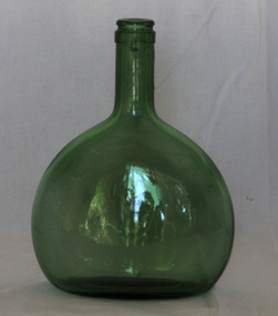 Orbost & District Historical Society
bottle
The Bocksbeutel ("goat's bag") bottle has been used since 1726 to store Franconian wines from south-east Germany. The Franken wine-growing region is in the north-west of Germany’s historic state of Bavaria. More than 40% of all Franken wines are bottled in the Bocksbeutel, which is often described as flagon-like in appearance. It is said that the bottle is so shaped to prevent it rolling away from its owner. Only Franken and nearby villages in northern Badenare allowed to use the Bocksbeutal, with selected areas in Portugal, Italyand Greece permitted to employ their own variations. (ref www,winesearcher)A bocksbeutel - a a flagon-shaped wine bottle in the form of a flattened ellipsoid. It is a clear green glass bottle which is seamed.Base - 3 8A 313 700 mlsbottle beverage wines bocksbeutel franken-wines -
 Eltham District Historical Society Inc
Photograph - Aerial Photograph, Landata, Research, Vic, Apr. 1963
Centred on present day Marconi Court, Research bounded by Maroondah Aqueduct to north, Thompson Crescent to south, Joselyn Drive to east and Eltham Research Oval to west. Historic Aerial Imagery Source: Landata.vic.gov.au Aerial Photo Details: Project No :486 Project : MELBOURNE (1963) PROJECT Run : 5 Frame : 62 Date : 04/1963 Film Type : B/W Camera : RC8 Flying Height : 5100 Scale : 9600 Film Number : 1805 GDA2020 : 37°42'24"S, 145°10'43"E MGA2020 : 339434, 5825157 (55) Melways : 22 F3 (ed. 42)aerial photo, neil webster collection, 1963-04, joselyn drive, marconi court, melway 22f3, research (vic.), research oval, thompson crescent -
 Eltham District Historical Society Inc
Photograph - Aerial Photograph, Landata, Research, Vic, Apr. 1972
Centred on present day Maroong Drive, Research bounded by Allendale Road to north, Thompson Crescent to south, Eltham College to east and Parsons Road to west. Historic Aerial Imagery Source: Landata.vic.gov.au Aerial Photo Details: Project No :985 Project : MELBOURNE 1972 Run : 26 Frame : 193 Date : 04/1972 Film Type : B/W Camera : RC10 Flying Height : 5700 Scale : 9600 Film Number : 2636 GDA2020 : 37°42'04"S, 145°10'33"E MGA2020 : 339187, 5825794 (55) Melways : 22 F1 (ed. 42)aerial photo, neil webster collection, 1972-04, allendale road, eltham, eltham barrel, eltham college, maroong drive, melway 22f1, parsons road, research (vic.), thompson crescent -
 Eltham District Historical Society Inc
Photograph - Aerial Photograph, Landata, Eltham, Vic, Apr. 1972
Centred on present day Ryans Road at Sandra Avenue, Eltham bounded by Progress Road to north, Brougham Street to south, Bible Street to east and Outlook Crescent to west. Historic Aerial Imagery Source: Landata.vic.gov.au Aerial Photo Details: Project No :985 Project : MELBOURNE 1972 Run : 27 Frame : 48 Date : 04/1972 Film Type : B/W Camera : RC10 Flying Height : 5700 Scale : 9600 Film Number : 2636 GDA2020 : 37°42'41"S, 145°08'38"E MGA2020 : 336392, 5824574 (55) Melways : 21 H4 (ed. 42)aerial photo, neil webster collection, 1972-04, eltham, bible street, brougham steet, melway 21h4, outlook crescent, progress road, ryans road, sandra avenue, montmorency -
 Eltham District Historical Society Inc
Photograph - Aerial Photograph, Landata, Montmorency, Vic, Apr. 1972
Centred on present day Olympic Avenue at Grand Boulevard, Montmorency bounded by Meruka Drive to north, Main Road to south, Main Road to east and Alban Street to west. Historic Aerial Imagery Source: Landata.vic.gov.au Aerial Photo Details: Project No :985 Project : MELBOURNE 1972 Run : 28 Frame : 206 Date : 04/1972 Film Type : B/W Camera : RC10 Flying Height : 5700 Scale : 9600 Film Number : 2635 GDA2020 : 37°43'21"S, 145°07'46"E MGA2020 : 335154, 5823329 (55) Melways : 21 E7 (ed. 42)aerial photo, neil webster collection, 1972-04, eltham, alban street, grand boulevard, lower plenty, main road, melway 21e7, meruka drive, montmorency, olympic avenue -
 Eltham District Historical Society Inc
Photograph - Aerial Photograph, Landata, Eltham, Vic, Apr. 1972
Centred on present day Mays Road at Stringybark Road, Eltham bounded by Nyora Road to north, Yarra River to south, Reynolds Road to east and Bible Street to west. Historic Aerial Imagery Source: Landata.vic.gov.au Aerial Photo Details: Project No :985 Project : MELBOURNE 1972 Run : 28 Frame : 209 Date : 04/1972 Film Type : B/W Camera : RC10 Flying Height : 5700 Scale : 9600 Film Number : 2635 GDA2020 : 37°43'33"S, 145°09'28"E MGA2020 : 337647, 5823013 (55) Melways : 22 B8 (ed. 42)aerial photo, neil webster collection, 1972-04, eltham, bible street, mays road, melway 22b8, nyora road, reynolds road, stringybark road, yarra river -
 Eltham District Historical Society Inc
Photograph - Aerial Photograph, Landata, Eltham, Main Road; Henry St to Bellevue Rd, Dec. 1945
Eltham, Main Road; Henry St to Bellevue Rd, and east along Luck St to present day Eltham East School Historic Aerial Imagery Source: Landata.vic.gov.au Aerial Photo Details: Project No :5 Project : MELBOURNE AND METROPOLITAN AREA PROJECT Run : 36 Frame : 60549 Date : 12/1945 Film Type : B/W Camera : EAG4 Flying Height : 10200 Scale : 6000 Film Number : 228 GDA2020 : 37°42'45"S, 145°08'59"E MGA2020 : 336903, 5824465 (55) Melways : 21 K4 (ed. 42)aerial photo, arthur street, bellevue road, bible street, diamond street, dudley street, elsa court, eltham, eltham east primary school, gahan house, henry street, livingstone road, luck street, main road, pryor street, neil webster collection -
Glen Eira Historical Society
Letter - Trinity Congregational Church, Glen Huntly
Roneod letter from the National Trust, Victoria, to the Congregational Union of Victoria. The correspondence gives notification that the church has been placed in the classified List and should be preserved. Dated 20/03/1973. Correspondence from Department of Planning Victoria, advising the Caulfield Historical Society, that the H. B. Council has chosen not to recommend the building for addition to the Historic Buildings Register Dated 08/10/1982. Extracted From Caulfield Conservation Study By Andrew Ward Dated January 1995 Describing Trinity Congregational Church. Includes Brief History Of The Church And Description Of Architectural Features.trinity congregational church., moran b., preston joane, grange road, caulfield., historic buildings council, glen huntly, hart trevor, grey karen, timber houses, filbert street, old calendar greek, primitive methodists, caulfield south, orthodox church, el nido grove, lyons street, porches, market gardens., gothic style, congregationalists, ward andrew, architectural features, architectural styles -
Glen Eira Historical Society
Article - Athole, Poplar Grove, 18, Carnegie
Two items about this property: 1/Pages 17 and 18 of the Real Estate section of the Caulfield Southern Cross 29/07/1992 including an article on Athole, Poplar Grove, 18, Carnegie, with a sketch of the house and a detained architectural description about its historic features. It also gives a brief history of the house and the life of its designer and owner, architect John T. Kelleher. Names and contact numbers of the Real Estate auctioneers are provided and there are a number of advertisements for other houses in Glen Eira. 2/A photocopy of 2 colour photographs of the exterior and garden of 'Athole' circa 2012.carnegie, poplar grove, athole, kelleher john t, biggin and scott, auctions, stables, stockdale and leggo, glen huntly, wattle avenue, munro avenue, edgewood street, brick houses, glen huntly road, glenhuntly road, j r buxton, caulfield south, pyne street, elsternwick, stanley street, noel jones and associates, brukarz jack, fitch karl, moonya road, wattle avenue, mcpherson street, timber houses, caulfield north, aroona road, dunbar avenue, urandaline grove, lascelles street, mclaurin road, trevelyan street -
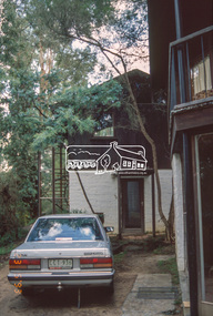
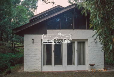 Eltham District Historical Society Inc
Slide - Photograph, Le Gallienne House, Yarra Braes Road, Eltham, 23 May 1993
Jean Downing's house, owned by Downing/Le Gallienne, an Alistair Knox house built in four stages between 1948 and 1964. The 1993 Eltham Heritage Tour was enjoyed by a busload of members of the Historical Society on a fine, calm day, Sunday May 23rd. Between 10.00 am and 4.30 pm, except for a brief lunch stop at the Eltham Living and Learning Centre, members passed about thirty places of local interest and others recommended for the Historic Buildings Register and the Register of the National Estate. A number of significant trees and buildings were also highlighted along with the opportunity to explored some of the properties.35mm colour positive transparency (1 of 24) Mount - Kodak Kodachromeactivities, shire of eltham historical society, heritage excursion, eltham, houses, le gallienne house, yarra braes road -
 Eltham District Historical Society Inc
Slide - Photograph, Le Gallienne House, Yarra Braes Road, Eltham, 23 May 1993
Jean Downing's house, owned by Downing/Le Gallienne, an Alistair Knox house built in four stages between 1948 and 1964. The 1993 Eltham Heritage Tour was enjoyed by a busload of members of the Historical Society on a fine, calm day, Sunday May 23rd. Between 10.00 am and 4.30 pm, except for a brief lunch stop at the Eltham Living and Learning Centre, members passed about thirty places of local interest and others recommended for the Historic Buildings Register and the Register of the National Estate. A number of significant trees and buildings were also highlighted along with the opportunity to explored some of the properties.35mm colour positive transparency (1 of 24) Mount - Kodak Kodachromeactivities, shire of eltham historical society, heritage excursion, eltham, houses, le gallienne house, yarra braes road