Showing 1953 items
matching kew - history
-
 Kew Historical Society Inc
Document, Sands & McDougall Ltd, Invitation to a ‘Conversazione’ in the Exhibition Building, 1901
A report in the Ballarat Star on 8 May 1901 recorded that: "THE CONVERSAZIONE. A GREAT SUCCESS. The conversazion given by the Government of Victoria at the Exhibition was very largely patronised. the guests includ ing the Prime Minister and a goodly proportion of the distinguished personages now in Melbourne. A programme of high-class music was gone through, and refreshments were served during the evening. Australian wines were very prominent."The document design has artistic and aesthetic merit. While it is not rare, it is representative of the kinds of formal designs used for the Australian Commonwealth celebrations at the time of Federation, and is in excellent condition. Such items as this invitation have local, state and national historic significance as mementoes of a key moment in Australia's history. Locally, the invitation is part of a group of Federation-related items owned and displayed by Mrs Grace Tabulo, the owner of 'Fairyland', 57 Malmsbury Street, Kew.Colour lithograph mounted on card to an evening event, a conversazione, held in the Exhibition Building on the evening of Tuesday 7th May 1901, as part of the Australian Commonwealth Celebrations. The Government of Victoria hosted the event. The invitation shows an etching of the Exhibition Building, surrounded by an ornate border of heraldic shields, portraits of the Duke and Duchess, views of Perth, Adelaide, Melbourne, Sydney, Brisbane and Hobart, and native flora (including wattle, waratah, pink heath, Sturt’s desert pea, and flannel flower), and native fauna (kookaburra, possum, lyre bird, cockatoo and koala). The royal crest ‘Dieu et mon droit’ and the Australian crest, ‘Advance Australia’ are also included.Printed front: UNITED AUSTRALIA 1901 / ONE FLAG / ONE HOPE / ONE DESTINY; AUSTRALIAN COMMONWEALTH CELEBRATIONS / THE GOVERNMENT OF VICTORIA requests the honour of the presence of / [name deleted] / at a Conversazione in the Exhibition Building on the Evening of Tuesday 7th May 1901 at 8 P.M. Reverse [handwritten]: Mrs G. Tabulo, 57 Malmsbury St.sands & mcdougall ltd, documents - invitations, first commonwealth parliament 1901, grace tabulo -- fairyland -- 57 malmsbury street -- kew (vic.) -
 Kew Historical Society Inc
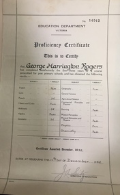
Certificate, Education Department (Victoria), Proficiency Certificate: George Harrington Rogers, 11/12/1942
This document was donated to the Kew Historical Society by John Rogers in 2015. Primary source for understanding the requirements of educational standards in Victoria in the 1940sEducation Department Victoria. Proficiency Certificate No.14942 This is to Certify that George Harrington Rogers has completed satisfactorily the first three years of a course prescribed for post primary school, and had obtained the following results. Pass - English, History and Civics, Algebra, Geography, Drawing, Physical Education and Hygiene, Physics, Chemistry. Certificate awarded 1942. Dated at Melbourne this 11th Day of December 1942. Signed Director of Education.certificates - education department victoria, proficiency certificates, george harrington rogers -
 Kew Historical Society Inc
Map, MMBW, MMBW Town of Kew, 1910-21
The Melbourne and Metropolitan Board of Works (MMBW) was established by an act of the Victorian Parliament in 1890 to prepare for and to implement a sewerage and water reticulation system across what was then inner Melbourne, its surrounding and middle distance suburbs, including Kew. The MMBW was disbanded in 1991.The map collection of the Kew Historical Society has at its core the historic maps assembled and originally stored in the City Engineer's Department of the City of Kew. These include maps in a number of scales. The vast majority of maps were produced by the MMBW in the first two decades of the twentieth century, and are solid working maps, backed by linen for durability. These maps are historically significant to Kew, the City of Boroondara and to the history of the development of state utilities in Victoria. A number of the Kew maps have additional details added by former municipal officers, including the levels reached by various floods. As these were working documents, information was added to them long after the period of their initial production and distribution.Early map of the Town of Kew, created after 1910, at a scale 440 ft to 1 inch. The 'assembled' map by the City of Kew Engineer's Department includes scaled down copies of The Melbourne and Metropolitan Board of Works maps, Nos. 39, 40, 64, 65, 66, 67, 68, and 117. The map covers the entirety of the Town of Kew, bordered on its north and west by the River Yarra, by Burke Road in the East and Barkers Road in the south. The map shows the extent of urban development by that time, prominent institutions and the outlines of built structures in the municipality. TOWN OF KEW / SCALE 400 FEET TO 1 INCHmelbourne & metropolitan board of works, mmbw maps, mmbw plans, town of kew, cartography -
 Kew Historical Society Inc
Map, MMBW, MMBW Plan No.39 Kew & Heidelberg, 1900-1910
The Melbourne and Metropolitan Board of Works (MMBW) was established by an act of the Victorian Parliament in 1890 to prepare for and to implement a sewerage and water reticulation system across what was then inner Melbourne, its surrounding and middle distance suburbs, including Kew. The MMBW was disbanded in 1991.The map collection of the Kew Historical Society has at its core the historic maps assembled and originally stored in the City Engineer's Department of the City of Kew. These include maps in a number of scales. The vast majority of maps were produced by the MMBW in the first two decades of the twentieth century, and are solid working maps, backed by linen for durability. These maps are historically significant to Kew, the City of Boroondara and to the history of the development of state utilities in Victoria. A number of the Kew maps have additional details added by former municipal officers, including the levels reached by various floods. As these were working documents, information was added to them long after the period of their initial production and distribution.Early map of part of the Borough of Kew, created in the first decade of the twentieth century, at a scale 160 ft to 1 inch. The map covers what was then the north western section of Kew, bordered on its north by Wills Street and the Kew Lunatic Asylum, in the west by the River Yarra [and the later added Yarra Boulevard] , by Princess Street in the East and Holroyd Street in the south. The map shows the extent of urban development by that time, prominent institutions and the outlines of built structures in the municipality. Contour lines were added in ink to the map at a later stage.MELBOURNE AND METROPOLITAN BOARD OF WORKS / PLAN NO. 39 / KEW & HEIDELBERGmelbourne & metropolitan board of works, mmbw maps, mmbw plans, borough of kew, cartography -
 Kew Historical Society Inc
Map, MMBW, MMBW Plan No.40 Collingwood & Kew, 1900-1910
The Melbourne and Metropolitan Board of Works (MMBW) was established by an act of the Victorian Parliament in 1890 to prepare for and to implement a sewerage and water reticulation system across what was then inner Melbourne, its surrounding and middle distance suburbs, including Kew. The MMBW was disbanded in 1991.The map collection of the Kew Historical Society has at its core the historic maps assembled and originally stored in the City Engineer's Department of the City of Kew. These include maps in a number of scales. The vast majority of maps were produced by the MMBW in the first two decades of the twentieth century, and are solid working maps, backed by linen for durability. These maps are historically significant to Kew, the City of Boroondara and to the history of the development of state utilities in Victoria. A number of the Kew maps have additional details added by former municipal officers, including the levels reached by various floods. As these were working documents, information was added to them long after the period of their initial production and distribution.Early map of part of the Borough of Kew, created in the first decade of the twentieth century, at a scale 160 ft to 1 inch. The map covers what was then the south western section of Kew, bordered on its north by Studley Park Road, in the west by Walmer Street and the River Yarra, by High Street South and Princess Street in the East and Barkers Road in the south. The map shows the extent of urban development by that time, prominent institutions and the outlines of built structures in the municipality. Contour lines and historic flood levels were added in ink to the map at a later stage.MELBOURNE AND METROPOLITAN BOARD OF WORKS / PLAN NO. 40 / COLLINGWOOD & KEWmelbourne & metropolitan board of works, mmbw maps, mmbw plans, borough of kew, cartography -
 Kew Historical Society Inc
Map, MMBW, MMBW Plan No.64 Kew & Heidelberg, 1900-1910
The Melbourne and Metropolitan Board of Works (MMBW) was established by an act of the Victorian Parliament in 1890 to prepare for and to implement a sewerage and water reticulation system across what was then inner Melbourne, its surrounding and middle distance suburbs, including Kew. The MMBW was disbanded in 1991.The map collection of the Kew Historical Society has at its core the historic maps assembled and originally stored in the City Engineer's Department of the City of Kew. These include maps in a number of scales. The vast majority of maps were produced by the MMBW in the first two decades of the twentieth century, and are solid working maps, backed by linen for durability. These maps are historically significant to Kew, the City of Boroondara and to the history of the development of state utilities in Victoria. A number of the Kew maps have additional details added by former municipal officers, including the levels reached by various floods. As these were working documents, information was added to them long after the period of their initial production and distribution.Early map of part of the Borough of Kew, created in the first decade of the twentieth century, at a scale 160 ft to 1 inch. The map covers what was then the northern most part of Kew, bordered on its north and west by the Yarra River, in the East by Connor's Creek and by the Asylum in the south. The map shows the extent of urban development by that time, prominent institutions and the outlines of built structures in the municipality. Contour lines and historic flood levels were added in ink to the map at a later stage.MELBOURNE AND METROPOLITAN BOARD OF WORKS / PLAN NO. 64 / KEW & HEIDELBERGmelbourne & metropolitan board of works, mmbw maps, mmbw plans, borough of kew, cartography -
 Kew Historical Society Inc
Map, MMBW, MMBW Plan No.65 Kew & Heidelberg, 1900-1910
The Melbourne and Metropolitan Board of Works (MMBW) was established by an act of the Victorian Parliament in 1890 to prepare for and to implement a sewerage and water reticulation system across what was then inner Melbourne, its surrounding and middle distance suburbs, including Kew. The MMBW was disbanded in 1991.The map collection of the Kew Historical Society has at its core the historic maps assembled and originally stored in the City Engineer's Department of the City of Kew. These include maps in a number of scales. The vast majority of maps were produced by the MMBW in the first two decades of the twentieth century, and are solid working maps, backed by linen for durability. These maps are historically significant to Kew, the City of Boroondara and to the history of the development of state utilities in Victoria. A number of the Kew maps have additional details added by former municipal officers, including the levels reached by various floods. As these were working documents, information was added to them long after the period of their initial production and distribution.Early map of part of the Borough of Kew, created in the first decade of the twentieth century, at a scale 160 ft to 1 inch. The map covers what was then the south central part of Kew, bordered on its north by Malmsbury Street, in the west by Florence Avenue, in the south by Barkers Road, and in the east by Princess Street. The map shows the extent of urban development by that time, prominent institutions and the outlines of built structures in the municipality. Contour lines were added in ink to the map at a later stage.MELBOURNE AND METROPOLITAN BOARD OF WORKS / PLAN NO. 65 / KEW & HEIDELBERGmelbourne & metropolitan board of works, mmbw maps, mmbw plans, borough of kew, cartography -
 Kew Historical Society Inc
Map, MMBW, MMBW Plan No.66 Kew, 1900-1910
The Melbourne and Metropolitan Board of Works (MMBW) was established by an act of the Victorian Parliament in 1890 to prepare for and to implement a sewerage and water reticulation system across what was then inner Melbourne, its surrounding and middle distance suburbs, including Kew. The MMBW was disbanded in 1991.The map collection of the Kew Historical Society has at its core the historic maps assembled and originally stored in the City Engineer's Department of the City of Kew. These include maps in a number of scales. The vast majority of maps were produced by the MMBW in the first two decades of the twentieth century, and are solid working maps, backed by linen for durability. These maps are historically significant to Kew, the City of Boroondara and to the history of the development of state utilities in Victoria. A number of the Kew maps have additional details added by former municipal officers, including the levels reached by various floods. As these were working documents, information was added to them long after the period of their initial production and distribution.Early map of part of the Borough of Kew, created in the first decade of the twentieth century, at a scale 160 ft to 1 inch. The map covers what was then the south eastern part of Kew, bordered on its north by Adeney Avenue, in the west by Sackville Street, in the south by Barkers Road, and in the east by Burke Road. The map shows the extent of urban development by that time, prominent institutions and the outlines of built structures in the municipality. Contour lines were added in ink to the map at a later stage.MELBOURNE AND METROPOLITAN BOARD OF WORKS / PLAN NO. 66 / KEW melbourne & metropolitan board of works, mmbw maps, mmbw plans, borough of kew, cartography -
 Kew Historical Society Inc
Map, MMBW, MMBW Plan No.67 Kew, 1900-1910
The Melbourne and Metropolitan Board of Works (MMBW) was established by an act of the Victorian Parliament in 1890 to prepare for and to implement a sewerage and water reticulation system across what was then inner Melbourne, its surrounding and middle distance suburbs, including Kew. The MMBW was disbanded in 1991.The map collection of the Kew Historical Society has at its core the historic maps assembled and originally stored in the City Engineer's Department of the City of Kew. These include maps in a number of scales. The vast majority of maps were produced by the MMBW in the first two decades of the twentieth century, and are solid working maps, backed by linen for durability. These maps are historically significant to Kew, the City of Boroondara and to the history of the development of state utilities in Victoria. A number of the Kew maps have additional details added by former municipal officers, including the levels reached by various floods. As these were working documents, information was added to them long after the period of their initial production and distribution.Early map of part of the Borough of Kew, created in the first decade of the twentieth century, at a scale 160 ft to 1 inch. The map covers what was then the north central part of Kew, bordered on its north by the Outer Circle Railway Spruzen and Beresford Avenues, in the west by Princess Street, in the south by High Street, and in the east by (about) Belford Road. The map shows the extent of urban development by that time, prominent institutions and the outlines of built structures in the municipality. Contour lines were added in ink to the map at a later stage.MELBOURNE AND METROPOLITAN BOARD OF WORKS / PLAN NO. 67 / KEW melbourne & metropolitan board of works, mmbw maps, mmbw plans, borough of kew, cartography -
 Kew Historical Society Inc
Map, MMBW, MMBW Plan No.68 Kew, 1900-1910
The Melbourne and Metropolitan Board of Works (MMBW) was established by an act of the Victorian Parliament in 1890 to prepare for and to implement a sewerage and water reticulation system across what was then inner Melbourne, its surrounding and middle distance suburbs, including Kew. The MMBW was disbanded in 1991.The map collection of the Kew Historical Society has at its core the historic maps assembled and originally stored in the City Engineer's Department of the City of Kew. These include maps in a number of scales. The vast majority of maps were produced by the MMBW in the first two decades of the twentieth century, and are solid working maps, backed by linen for durability. These maps are historically significant to Kew, the City of Boroondara and to the history of the development of state utilities in Victoria. A number of the Kew maps have additional details added by former municipal officers, including the levels reached by various floods. As these were working documents, information was added to them long after the period of their initial production and distribution.Early map of part of the Borough of Kew, created in the first decade of the twentieth century, at a scale 160 ft to 1 inch. The map covers what was then the north central part of Kew, bordered in the north by Oak Avenue, in the west by the Yarra River and Connor's Creek, in the south by Beresford and Carnegie Avenues, and in the east by Glass's Creek and Burke Road. The map shows the extent of urban development by that time, prominent institutions and the outlines of built structures in the municipality. Contour lines and the levels of historic floods were added in ink to the map at a later stage.MELBOURNE AND METROPOLITAN BOARD OF WORKS / PLAN NO. 68 / KEW melbourne & metropolitan board of works, mmbw maps, mmbw plans, borough of kew, cartography -
 Kew Historical Society Inc
Map, MMBW, MMBW Plan No.117 Heidelberg & Kew, 1900-1910
The Melbourne and Metropolitan Board of Works (MMBW) was established by an act of the Victorian Parliament in 1890 to prepare for and to implement a sewerage and water reticulation system across what was then inner Melbourne, its surrounding and middle distance suburbs, including Kew. The MMBW was disbanded in 1991.The map collection of the Kew Historical Society has at its core the historic maps assembled and originally stored in the City Engineer's Department of the City of Kew. These include maps in a number of scales. The vast majority of maps were produced by the MMBW in the first two decades of the twentieth century, and are solid working maps, backed by linen for durability. These maps are historically significant to Kew, the City of Boroondara and to the history of the development of state utilities in Victoria. A number of the Kew maps have additional details added by former municipal officers, including the levels reached by various floods. As these were working documents, information was added to them long after the period of their initial production and distribution.Early map of part of the Borough of Kew, created in the early twentieth century, at a scale 160 ft to 1 inch. The map covers what was then the north eastern part of Kew showing the natural landscape and limited development on the south side of the Yarra River. In the Kew section, south of the river, the land is occupied currently by the Greenacres and Kew Golf Clubs. The map shows the extent of urban development by that time and the outlines of the few built structures in the municipality. The height above sea level of all parts of the landscape are indicated numerically in feet. Contour lines and the levels of historic floods were added in ink to the map at a later stage. MELBOURNE AND METROPOLITAN BOARD OF WORKS / PLAN NO. 117 / HEIDELBERG & KEW melbourne & metropolitan board of works, mmbw maps, borough of kew, cartography, mmbw plan no. 117, kew (vic.) -- maps, heidelberg (vic.) -- maps -
 Kew Historical Society Inc
Map, MMBW, River Yarra Beautification Schemes, c.1913
The Melbourne and Metropolitan Board of Works (MMBW) was established by an act of the Victorian Parliament in 1890 to prepare for and to implement a sewerage and water reticulation system across what was then inner Melbourne, its surrounding and middle distance suburbs, including Kew. The MMBW was disbanded in 1991.The map collection of the Kew Historical Society has at its core the historic maps assembled and originally stored in the City Engineer's Department of the City of Kew. These include maps in a number of scales. The vast majority of maps were produced by the MMBW in the first two decades of the twentieth century, and are solid working maps, backed by linen for durability. These maps are historically significant to Kew, the City of Boroondara and to the history of the development of state utilities in Victoria. A number of the Kew maps have additional details added by former municipal officers, including the levels reached by various floods. As these were working documents, information was added to them long after the period of their initial production and distribution.Map of the City of Kew showing part of the River Yarra Beautification Schemes. The map shows development to date and the flood levels reached in 1923 and 1924. This map may have been adapted from an earlier map, as most development in central Kew and Studley Park had occurred by this date yet numerous streets are not represented. Public buildings and institutions are clearly represented and named on the map as are significant public transport infrastructure (eg the Outer Circle railway).MELBOURNE AND METROPOLITAN BOARD OF WORKS / RIVER YARRA BEAUTIFICATION SCHEMES / SCHEME / SCALE 10 CHAINS TO AN INCHmelbourne & metropolitan board of works, mmbw maps, mmbw plans, city of kew, flood levels -- kew (vic.), cartography -
 Kew Historical Society Inc
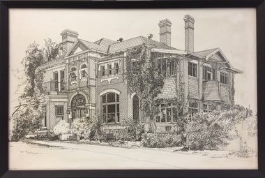
Print - 'Monnington', Adeney Avenue, Trompf, 1977
In the mid 1960s, the Monnington Special Education Centre was established at 15 Adeney Avenue as an offshoot to 'Glendonald' in Marshall Avenue. In 1988, the amalgamation of Princess Elizabeth Junior School for Deaf Children, the Monnington Centre and Carronbank School for Deaf Blind Students allowed the Victorian Government to sell each of the sites. Monnington [Adeney Avenue, Kew] reverted to private ownership, while Glendonald and Carronbank in Marshall Avenue were demolished and subdivided. The donor, Mr Murray Osler, was Principal of the Monnington Special Education Centre in Adeney Avenue (Kew) from 1976. This photo, and an accompanying drawing of 'Carronbank' are important primary resources for the history of the delivery of education to and for deaf-blind children in Victoria.Gift of Murray Osler, 2021This limited and numbered print [number 10/100], framed under perspex, is of Monnington in Adeney Avenue, Kew when it functioned as a Special Education Centre for deaf/blind children during the 1960s to the 1990s. . "Monnington Special Ed. Centre / 60s-90s / (Parent Guidance for Deaf/Blind Ch. / Adeney Ave, Kew / Murray Osler / Principal 76-80s"schools -- kew (vic.), mornington -- adeney avenue -
 Kew Historical Society Inc
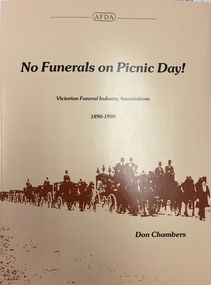
Book, Don Chambers, No funerals on picnic day! : Victorian funeral industry associations, 1890-1990, 1990
... undertakers and undertaking -- victoria -- history. East Kew, Vic ...East Kew, Vic. : Australian Funeral Directors Association Victorian Division, 1990. xiv, 157 p. : ill. ; 28 cm. Includes index. Available from The Association, 722 High St, East Kew Vic 3102. Bibliography: p. 135.non-fictionundertakers and undertaking -- victoria -- history. -
 Kew Historical Society Inc
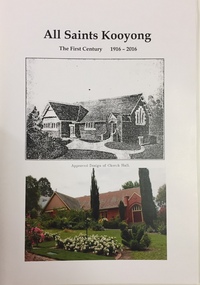
Book, Nigel Davies, All Saints Kooyong: The first century 1916-2016, 2017
The history of All Saints Anglican Church in Glenferrie Road, Kooyong.non-fictionThe history of All Saints Anglican Church in Glenferrie Road, Kooyong. undertakers and undertaking -- victoria -- history. -
 Kew Historical Society Inc
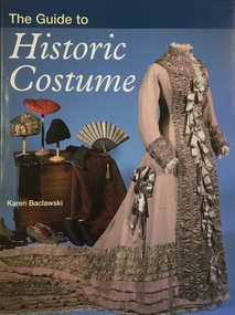
Book, Karen Baclawski, The Guide to Historic Costume, 1995
... Kew Historical Society Inc 1 Civic Drive Kew melbourne ...With 270 photographs and the discussion of 250 categories of costume, The Guide to Historic Costume provides the most detailed, comprehensive and up-to-date survey of surviving historic costume in a single volume. Fabric, colour, shape, social and historical context - all give weight and substance to this authoritative source of factual information.239 p. : ill. ; 26 cm.non-fictionWith 270 photographs and the discussion of 250 categories of costume, The Guide to Historic Costume provides the most detailed, comprehensive and up-to-date survey of surviving historic costume in a single volume. Fabric, colour, shape, social and historical context - all give weight and substance to this authoritative source of factual information.fashion - history, costume - history, clothing - history -
 Kew Historical Society Inc
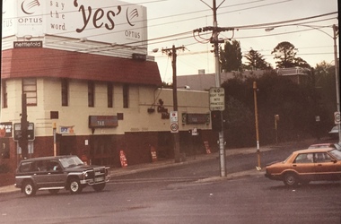
Photograph - Clifton Hotel, Kew Junction, 1994
Of the eight hotels established in Kew since European settlement, The Hotel Kew, known for most of its existence, as the Clifton Hotel was the seventh to be built in 1868. Its location on the corner of Studley Park Road and High Street at Kew Junction makes it a prominent landmark. Its current name is confusing for local historians as its main rival for the first 52 years was O'Shaughnessy's Hotel (1855), later renamed the Kew Hotel, on the corner of High Street and Denmark Street. Looking at the façade of the Hotel Kew, it is hard to imagine its mid-nineteenth appearance. There have probably been at least four renovations or rebuilding(s) of the structure. The documented renovations have occurred in the 1930s when the late Victorian façade was given an Art Deco update. In about 1970 its façade was again 'improved'. The many publicans who have held the licenses of the Clifton Hotel have been identified in in the 'Tetlow Index' and on the 'Boroondara Local History Wiki'. The most significant of these are Henry Madden (1880-87); Michael O'Donnell (1902-1920); and the Cronin-Ryan family (1935–53ff).Fading colour positive photograph of the Clifton Hotel at Kew Junction on the corner of High Street South and Studley Park Road. The hotel had been modified extensively over time, disguising the original Italianate facade. This is the colour scheme of the fourth restoration, including huge advertising billboards on the roof.Reverse: "Clifton Hotel. Studley Park Road at Kew Junction. 1994clifton hotel -- kew (vic.), hotels -- kew (vic.), kew junction -
 Kew Historical Society Inc
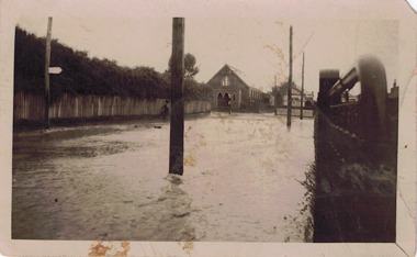
Photograph - Flooded street, 1940-50
View of unknown flooded streetscape.Original, black and white positive of a flooded street, originally believed to have been in Kew, but based on an examination of the history, deemed not to be a location in Kew or Kew East. The flooding is of a T-intersection with a brick church and a house in the background.Inscribed verso: "? Kew / R 774 / VELOX"floods -
 Kew Historical Society Inc
Administrative record, City of Kew, City of Kew Voters Roll 1986-1987 Central Ward, 1986-1987
non-fictionlocal government -- electoral rolls -- kew (vic) -
Kew Historical Society Inc
Administrative record, City of Kew, City of Kew Voters Roll 1986-1987 College Ward, 1986-1987
non-fictionlocal government -- electoral rolls -- kew (vic) -
Kew Historical Society Inc
Administrative record, City of Kew, City of Kew Voters Roll 1986-1987 North Ward, 1986-1987
non-fictionlocal government -- electoral rolls -- kew (vic) -
Kew Historical Society Inc
Administrative record, City of Kew, City of Kew Voters Roll 1986-1987 Studley Park Roll, 1986-1987
non-fictionlocal government -- electoral rolls -- kew (vic) -
Kew Historical Society Inc
Administrative record, City of Kew, City of Kew Voters Roll 1990-1991 Prospect Ward, 1990-1991
non-fictionlocal government -- electoral rolls -- kew (vic) -
Kew Historical Society Inc
Administrative record, City of Kew, City of Kew Voters Roll 1990-1991 Studley Park Ward, 1990-1991
non-fictionlocal government -- electoral rolls -- kew (vic) -
Kew Historical Society Inc
Administrative record, City of Kew, City of Kew Voters Roll 1990-1991 Willsmere Ward, 1990-1991
non-fictionlocal government -- electoral rolls -- kew (vic) -
Kew Historical Society Inc
Book, Oxford University Press, Costume in Australia 1788-1901, 1984
non-fictionfashion -- australia 1788-1901, costume -- australia -- history -
Kew Historical Society Inc
Book, Charles E Sayers, David Syme: A Life, 1965
viii, 311 p., 12 leaves of plates : ill., ports ; 25 cm. non-fictionaustralia -- victoria -- biography, newspaper proprietors -- victoria, syme david --1827-1908, newspaper publishing -- australia -
Kew Historical Society Inc
Book, Roger Leong, Dressed to Kill: 100 Years of Fashion, 2010
80 p. : ill. (some col.), ports. ; 30 cm. non-fictionnational gallery of australia -- exhibitions, costume -- history -- 20th century -- exhibitions, costume -- history -- 19th century -- exhibitions, fashion design -- history -- 20th century -- exhibitions, fashion design -- history -- 19th century -- exhibitions, fashion -- history -- 20th century -- exhibitions, fashion -- history -- 19th century -- exhibitions, fashion and art -- exhibitions. -
Kew Historical Society Inc
Book, Oxford University Press, Early Melbourne Architecture 1840 to 1888, 1966
184p. : chiefly ill. ; 24cm. non-fictionbuildings of historical importance -- architectural features -- melbourne 1840-1888 --illustrations, architecture -- victoria -- melbourne -- pictorial works, melbourne (vic.) -- buildings, structures etc. -- pictorial works -
Kew Historical Society Inc
Book, Brian Carroll, Early Melbourne Sketchbook, 1977
62p. : ill. ; 19x26cm. non-fictionbuildings of historical importance -- architectural features -- melbourne, historic buildings -- victoria -- melbourne