Showing 2265 items
matching map collections
-
 Tarnagulla History Archive
Photocopies of historic maps - Tarnagulla region, varied
David Gordon Collection. Four photocopies in clear sleeve: (a) topographic with mines near Tarnagulla (b) Parish map ?- Tarnagulla & surrounds (c) Parish map ?- Tarnagulla & surrounds (d) Plan of Roads, Tarnagulla & Newbridge -
Tarnagulla History Archive
Photocopies of historic maps - Waanyarra region, varied
David Gordon Collection. Five photocopies in clear sleeve. -
Tarnagulla History Archive
Photocopies of historic maps - County of Gladstone, including Llanelly & Tarnagulla, varied
David Gordon Collection. Two photocopies in clear sleeve. -
Tarnagulla History Archive
Photocopy of historic map - Township of Llanelly, varied
David Gordon Collection. One photocopy in clear sleeve. -
Tarnagulla History Archive
Photocopies of historic maps - Township of Newbridge, varied
David Gordon Collection. Three photocopies in clear sleeve. -
Tarnagulla History Archive
Photocopies of historic maps - Tarnagulla & surrounds, varied
David Gordon Collection. 14 photocopies in clear sleeve. Includes Tarnagulla goldfields maps. -
Tarnagulla History Archive
Display folder containing photocopied maps of lands in Tarnagulla and district
David Gordon Collection. -
Tarnagulla History Archive
Display folder containing photocopied maps and news content, relating to Tarnagulla & district
David Gordon Collection. -
Tarnagulla History Archive
Set of Maps (Mining & Local Area), various
David Gordon Collection. A set of mining documents, maps and plans: 1. Dunolly Deep Leads - showing location and names of deep lead gold deposits in region around Dunolly including at Tarnagulla and Newbridge. Geological Survey of Victoria, Department of Minerals and Energy. Bulletin No. 62, Map No. 4 Dunolly (770 x 485 mm). 2. Poseidon Lead (Facsimile) 3. Nick O Time Lead (Facsimile) 4. Happy Go Lucky Mine prospectus and plan (colour copy) 5. Jones Creek GM Co. (Raven & Gourlay's) Waanyarra - Prospectus (colour copy) 6. Poseidon Area Plan (colour copy) and Poseidon Area map (B&W copy). 7. Cross-section diagram of Spread Eagle Reef 8. New Birthday Gold Mine - area map (colour copy) and mine cross-section ( (colour copy). 9. Cross section of Poverty Reef, by Department of Mines (B&W copy, 2 parts on A2 paper) 10. Time-Lease Graph for Watts Reef, Specimen Reef, Stony Reef, Poverty Reef (second page in detail), created by Eric WIlkinson for Ref Mining NL, 1995 11. 1859 Plan of the Gold Workings & Township of Sandy Creek, Shewing the Mining Leases, Extended Claims & Machinery by R.J. McMillan, Mining Surveyor (B&W copy) 12. Longitundinal and Transverse Vertical Sections of Poverty Reef, Sandy Creek 1859, by R.J. McMillan, Mining Surveyor (B&W copy) 13. Tarnagulla Locality Plan (B&W copy) 14. Universal Grid Reference Map (Topographic) for Laanecoorie North (2 copies) 15. Universal Grid Reference Map (Topographic) for Inglewood South 16. Poverty Reef, Plan showing shafts and early tenements, created by Eric WIlkinson for Ref Mining NL, 1995 17. Locality Map of mining leases in Tarnagulla 18. Plan and Elevation of part of Poverty Reef, Sandy Creek, showing the claims and positions of the shaft. by R.J. McMillan, Mining Surveyor (Facsimile, composed of taped together components) 19.Plan and Elevation of part of Poverty Reef, Sandy Creek, showing the claims and positions of the shaft. by R.J. McMillan, Mining Surveyor (Facsimile, composed of taped together components) -
Tarnagulla History Archive
'Pippin's Valley' by Don Clark, Donald Clark, 1st March 1998
Donald Clark Collection.Two copies of a typed first-hand account written by amateur historian Don Clark of the people who lived in Pippin's Valley near Tarnagulla . For each property there is a reference number and explanation of the residents as remembered by the author. It is accompanied by a map with the reference numbers marked on properties. -
 Tarnagulla History Archive
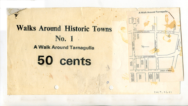
Clippings: Tarnagulla Historic Walk, circa 1960s-1980s
Donald Clark Collection.Three paper clippings, stapled together. One has printed text "Walks Around Historic Towns No.1 A Walk Around Tarnagulla 50 Cents". The other two are a photo of the Tarnagulla Wesleyan Church and a map of Tarnagulla marked with highlights.tourism -
 Tarnagulla History Archive
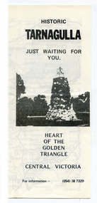
Brochure: Historic Tarnagulla, circa 1990s
Donald Clark Collection.Foldable photocopied brochure with title 'Historic Tarnagulla, Just Waiting For You'. Contains a map of the region marked with day trip places of interest. Also has a list of 'Things to Do and See' and a list of local traders in Tarnagulla.tourism, local history, walking tours -
 Tarnagulla History Archive
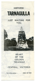
Brochure: Historic Tarnagulla, circa 1990s
Donald Clark Collection.Foldable photocopied brochure with title 'Historic Tarnagulla, Just Waiting For You'. Contains a map of the region marked with day trip places of interest. Also has a list of 'Things to Do and See' and a list of local traders in Tarnagulla.tourism, local history, walking tours -
Tarnagulla History Archive
VIMP Report 71 - Tarnagulla Goldfield, 2001
David Gordon Collection. Plastic pouch with book-style report and a folded map. -
Tarnagulla History Archive
Tarnagulla Maps by John Tully, 1988
... Commercial Rd Tarnagulla goldfields David Gordon Collection ...David Gordon Collection. -
 Melbourne Legacy
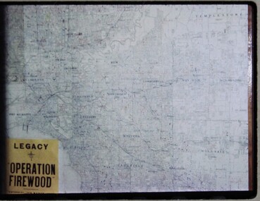
Slide, Operation Firewood, 1960s
Three colour slides of a map of Metropolitan Melbourne with pins showing many delivery addresses. It was during Operation Firewood. Legatees would organise collection of wood from the country and distribute it to widows in metropolitan Melbourne. Other slides show the cutting and loading of wood and delivery to widows in metropolitan Melbourne. Was with many other slides taken in the 1950s and 1960s. The slides have been photographed to make digital images and moved to archive quality sleeves. In many cases the original images were not well focussed and the digital image the best available.A record of Legacy helping widows by sourcing, supplying and delivering firewood. When open fires were the main source of heating, a load of firewood and help moving it, would have been very important to the widows.Colour slide x 3 of a map of Melbourne during Operation Firewood in white cardboard mount.Printed on front in blue ink 'Made in Australia'. Hand written on one slide 'Map of Operation Firewood' in pencil.operation firewood, maps -
 Melbourne Legacy
Slide, Operation Firewood, 1960s
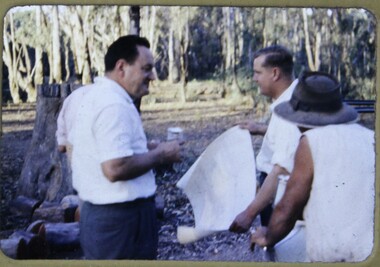
Colour slide of three legatees and a map in a forest. The caption identifies Ken Brumbrell and Graham Fogarty. It was during Operation Firewood. Legatees would organise collection of wood from the country and distribute it to widows in metropolitan Melbourne. Other slides show the cutting and loading of wood and delivery to widows in metropolitan Melbourne. Was with many other slides taken in the 1950s and 1960s. The slides have been photographed to make digital images and moved to archive quality sleeves. In many cases the original images were not well focussed and the digital image the best available.A record of Legacy helping widows by sourcing, supplying and delivering firewood. When open fires were the main source of heating, a load of firewood and help moving it, would have been very important to the widows.Colour slide of a view of Legatees during Operation Firewood in brown Anscochrome cardboard mount.Printed on front in red ink 'Anscochrome / View from this side / Made in Australia'. Hand written on front 'The deamon drivers out from Picola / Ken Bumbrell / Graham Fogarty' in blue pen. Printed on reverse in red ink 'Processed by Verycolor photo labs. Melbourne, Victoria'.operation firewood, legatees -
 Melbourne Legacy
Slide, Operation Firewood, 1960s
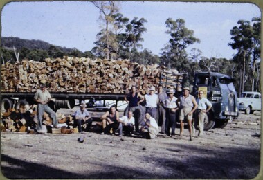
Colour slides of Operation Firewood. Legatees would organise collection of wood from the country and distribute it to widows in metropolitan Melbourne. Photos include the cutting of logs, loading of semi trailers, support crew of Legatees wives, distribution maps and delivery to widows. Was with many other slides taken in the 1950s and 1960s. The slides have been photographed to make digital images and moved to archive quality sleeves. In many cases the original images were not well focussed and the digital image the best available.A record of Legacy helping widows by sourcing, supplying and delivering firewood. When open fires were the main source of heating, a load of firewood and help moving it, would have been very important to the widows.Colour slide x 37 of Operation Firewood in brown Anscochrome cardboard mount.Printed on front in red ink 'Anscochrome / View from this side / Made in Australia'. Printed on reverse in red ink 'Processed by Verycolor photo labs. Melbourne, Victoria'.operation firewood, semi trailers -
 Parks Victoria - Mount Buffalo Chalet
Map, "Railway Map of Victoria"
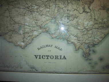
Large framed map of Victoria, showing Victorias extensive rail network. Printed by Victorian Railways and is one of a number of 'framed pictures, particularly photographs of scenery, which have always been a feature of the Chalet.' (Pg 83. Historica, 2011) This map has been a permanent fixture situated in the hallway alongside the ballroom leading to the ski hire area since the 1950's and most likely earlier. Listed in Draft Inventory of Significant Collection ItemsLarge railway map of Victoria, Melbourne & Ballarat framed in white painted wood. Scale eight miles to one inch. Areas of the map have been whited out.Yes -
 Parks Victoria - Mount Buffalo Chalet
Magazine, "Victorian Railways November 1974"
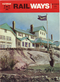
'Over the years the VR Advertising Division published a number of booklets promoting Mount Buffalo's sports and restorative powers of its scenery in summer and winter...The collection (MBCC) comprises a good range of tourist writing published as promotional booklets, guidebooks, brochures, walking trails, maps and newspaper articles.' (Pg. 119. Historica) This Victorian Railways monthly publication and also the VR Newsletter, published by the Victorian Railways Printing Works in North Melbourne, is one of a number which featured iconic photos of the Chalet of the plateau on its cover, as an identifiable flagship for The Victorian Railways and it's employees from the Railways Refreshment and Services Branch. These publications also have stories regarding upgrades and on long serving staff of the Chalet.Listed in Draft Inventory of Significant Collection Items . Appendix A.3. Promotional material.. (Pg 168. Historica).Railways magazine featuring an image of the chalet on the front cover and an article about the Chalet.Yes -
 Falls Creek Historical Society
Plan - Leases of part of Falls Creek Tourist Area
Bob (Herman) Hymans (a former member of the Royal Netherlands Navy was born in Bloemendaal, Holland on 30th September 1922. During World War II he fought against the Japanese in the Dutch East Indies (now Indonesia) and was imprisoned in Changi and on the Burma Railway. After gaining qualifications as a Ski Instructor, Bob arrived in Falls Creek in May 1950. Working as an Instructor and Supervisor at Bogong Lodge, Bob decided his future was in accommodation. He was successful in negotiating an indenture for land from the State Electricity Commission (SEC). It took Bob two years to build his Grande Coeur Chalet but, tragically, it was burned down in August 1961. Bob also built the first Chairlift in Australia. This was a single chairlift and the structure was built from wooden electricity poles. He was constantly full of new ideas and proposals for the village. Bob Hymans died on 7th May 2007. This Collection of documents and letters tells the story of Bob’s endeavours to develop Falls Creek into the ski village it is today. This map is significant because it documents boundaries of early leases in Falls Creek Tourist Area.This map is part of Bob Hymans documents. It is a large Surveyor's Plan of a section of the Falls Creek Tourist Area. It is endorsed by J Parker, Chief Surveyor of the State Electricity Commission of Victoria on 27-3-84. It shows streets, lot numbers and measurements. It was a compilation created from existing lease maps. Heading - PART OF FALLS CREEK TOURIST AREA PART OF CROWN ALLOTMENT 1 PARISH OF CARRUNO PART OF CROWN ALLOTMENT 1 PARISH OF DARBALANG COUNTY OF BOGONGmap of falls creek, falls creek leases, falls creek 1980s -
 Falls Creek Historical Society
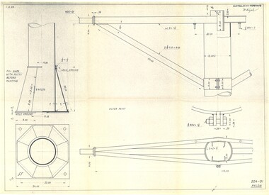
Plan - Diagram of Pylon for New Chairlift
Bob (Herman) Hymans (a former member of the Royal Netherlands Navy was born in Bloemendaal, Holland on 30th September 1922. During World War II he fought against the Japanese in the Dutch East Indies (now Indonesia) and was imprisoned in Changi and on the Burma Railway. After gaining qualifications as a Ski Instructor, Bob arrived in Falls Creek in May 1950. Working as an Instructor and Supervisor at Bogong Lodge, Bob decided his future was in accommodation. He was successful in negotiating an indenture for land from the State Electricity Commission (SEC). It took Bob two years to build his Grande Coeur Chalet but, tragically, it was burned down in August 1961. Bob also built the first Chairlift in Australia. This was a single chairlift and the structure was built from wooden electricity poles. He was constantly full of new ideas and proposals for the village. Bob Hymans died on 7th May 2007. This Collection of documents and letters tells the story of Bob’s endeavours to develop Falls Creek into the ski village it is today. This map is significant because it documents plans being proposed by Bob Hymans for Falls Creek.This diagram is part of Bob Hymans documents. It contains design drawings, measurements and cross sections for one of the pylons for a chairlift proposed by Bob Hymans. The design has been drawn up by Australasian Ropeways. It has been signed by Vladimir Hájek, a Czech engineer who Mr Hymans had consulted on several projects.Top right: AUSTRALASIAN ROPEWAYS with signature V. Hájek Bottom right: 204-01 PYLONmap of falls creek, falls creek leases, falls creek 1980s -
 Falls Creek Historical Society
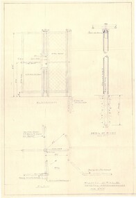
Plan - Diagram of Turnstile for New Chairlift
Bob (Herman) Hymans (a former member of the Royal Netherlands Navy was born in Bloemendaal, Holland on 30th September 1922. During World War II he fought against the Japanese in the Dutch East Indies (now Indonesia) and was imprisoned in Changi and on the Burma Railway. After gaining qualifications as a Ski Instructor, Bob arrived in Falls Creek in May 1950. Working as an Instructor and Supervisor at Bogong Lodge, Bob decided his future was in accommodation. He was successful in negotiating an indenture for land from the State Electricity Commission (SEC). It took Bob two years to build his Grande Coeur Chalet but, tragically, it was burned down in August 1961. Bob also built the first Chairlift in Australia. This was a single chairlift and the structure was built from wooden electricity poles. He was constantly full of new ideas and proposals for the village. Bob Hymans died on 7th May 2007. This Collection of documents and letters tells the story of Bob’s endeavours to develop Falls Creek into the ski village it is today. This map is significant because it documents plans made by Bob Hymans for Falls CreekThis diagram is part of Bob Hymans documents. It is a detailed plan, including elevation, detail of pivot and the general arrangement views of a turnstile. This is part of overall plans for the construction of a new chairlift at Falls Creek. At bottom of diagrams: PLAN TURNSTILE/ GENERAL ARRANGEMENT Scale 1 1/2" = 1'- 0"map of falls creek, falls creek leases, falls creek 1980s -
 Friends of Ballarat Botanical Gardens History Group
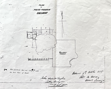
Work on paper - Site of the Ballarat Botanical Gardens, Plan of Police Paddock, Ballarat, 6th October 1855, October, 1855
Plan of Police Paddock, Ballarat, 6th October 1855.In 1855, the Police Paddock occupied the land of the present Ballarat Botanical Gardens.One large white sheet of paper photocopied and folded with a black margin at either end, and the plan and printing in longhand.The Plan is signed and dated by the Acting Surveyor and Assistant Surveyor, October, 1855.john garner collection, garner, dr, police, paddock, plan, map, 1855, ballarat botanical gardens, ballarat, gardens, wendouree, swamp. -
 Friends of Ballarat Botanical Gardens History Group
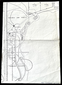
Work on paper - 1885 Map, Ballarat Botanic and Public Gardens Reserve, 1885
... Wendouree area in 1885. John Garner Collection garner dr map early ...Botanic and Public Gardens Reserve: Early Map.This Plan shows how the Ballarat Botanic Gardens had been set out and part of the Lake Wendouree area in 1885.One large cream sheet of paper, folded in two.bottom of the page on the right in blue biro, "From: Jim Reynolds, 29.10.94".john garner collection, garner, dr, map, early, gardens reserve, ballarat botanical gardens, ballarat, gardens, 1885, public, wendouree parade, w. barbour. -
Friends of Ballarat Botanical Gardens History Group
Work on paper - National Trust of Australia (Vic), Register of Significant Trees. Ballarat Botanical Gardens. c1983, Unknown
This National Trust Register of Significant Trees in the Ballarat Botanical Gardens is an important part of Ballarat's history. Unfortunately, since 1983, some of the trees listed have died or been removed.The Ballarat Botanical Gardens has a unique collection of trees which testify to the knowledge and enthusiasm of the Curators, City fathers and Gardeners in their development of the Gardens in earlier years, especially in the nineteenth century.1 sheet of paper with three lists of the trees and the number of them in the Gardens. (1 copy)Draft printed in red under main heading. In black biro, written on the first entry, "no on map". 10th entry (Sierra Redwood) number scribbled over and "outside gate" written. 14th entry (Horizontal Elm) "3 on list, 1dead". 15th entry (Horizontal Elm) "W of 17". ballarat botanical gardens, national trust of australia (vic), register of significant trees, trees, john garner collection, gardens, ballarat -
Friends of Ballarat Botanical Gardens History Group
Work on paper - Gondwana Trees in the Ballarat Botanical Gardens, Categories and Common Features, Unknown
Part of an attempt to to categorise and identify common features of the wide range of trees in the Ballarat Botanic Gardens.This material deals with the history of Gondwana trees and those represented in Australia today that relate to plants found in the Ballarat Botanical Gardens.4 pages. p.1 Map of Pangaea (Continents) left hand 2nd half of page. p2. Map, left hand top of page and 2 photographs of foliage, 2nd half of page. p 3. 5 small photographs down left hand side of page. p.4 no photographs or maps. none.john garner, doctor, ballarat botanical gardens, gondwana trees in the ballarat botanical gardens, pangaea, trees., john garner collection, gardens, ballarat -
 Friends of Ballarat Botanical Gardens History Group
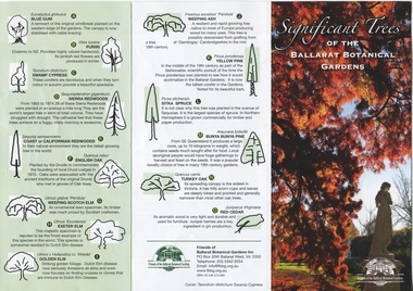
Work on paper - Significant Trees of the Ballarat Botanical Gardens, List and Map, c 2018
These trees planted in the nineteenth century are an exceptional collection of exotic conifers and deciduous trees.These trees classified by the National Trust means that the trees are an essential part of Australia's heritage and should be preserved for future generations.A coloured pamphlet divided into three parts, with trees and coloured picture on one side and a map of where the trees are situated on the other.Right hand corner of coloured picture, there is the logo of the Friends of the Ballarat Botanical Gardensjohn garner collection, dr, significant trees, ballarat botanical gardens, gardens, ballarat, map -
Friends of Ballarat Botanical Gardens History Group
Work on paper - Wellingtonia, Autumn 2014, Tree of the Month, Autumn, 2014
This page gives historical information of Gondwana found in the Ballarat Botanical Gardens.These families of plants are confined originally to Australasia and South America and at least 15 are to be found in the Ballarat Botanical Gardensp.4 of the Friends of Ballarat Botanical Gardens periodical, The Wellingtonia. This is a printed page with 2 maps of the Globe, right-hand side of the page.None.john garner, doctor, doctor john garner, tree of the month, gondwana trees in the ballarat botanical gardens, friends of ballarat botanical gardens, history group, conifers, bunya bunya pine, monkey puzzle, wellingtonia, araucaria, john garner collection, gardens, ballarat -
 Friends of Ballarat Botanical Gardens History Group
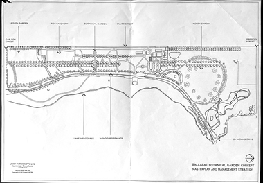
Work on paper - Ballarat Botanical Garden Concept, Masterplan and Management Strategy, Unknown
... This map is important in terms of the planning and management ...This map is important in terms of the planning and management of the Ballarat Botanic Gardens The Map adds to our understanding and knowledge of the history of the Ballarat Botanical Gardens 1 page of a map in black and white. the number 44 is circled in pencil on the top righthand corner of the back of the page.john garner, doctor, john garner collection, ballarat botanic gardens, maps, masterplan, management strategy, john patrick, landscape consultants, ballarat city council, friends of ballarat botanical gardens, gardens, ballarat