Showing 11164 items matching "planning "
-
 Clunes Museum
Plan - PLANS CLUNES CARAVAN PARK, NO. 1 - SHIRE OF TALBOT & CLUNES. IAN MANSLEY, SHIRE ENGINEER NO. 2 - LEO MCMAHON & ASSOCIATES PTY. LTD. LICENSED SURVEYORS & ENGINEERS, 31 LYONS ST. NTH. BALLARAT, 1976
NO. 1 PLAN - CLUNES CARAVAN PARK ENGINEER - IAN MANLEY NO. 2 PLAN - SECTION 15 TOWNSHIP OF CLUNES, COUNTY OF TALBOT, BY LEO MCMAHON AND ASSOCIATES, LICENSED SURVEYORS AND CIVIL ENGINEERSplans, caravan park, ian manley, plan section 15 -
Whitehorse Historical Society Inc.
Pamphlet, Halliday Park, c1988
A pamphlet describing Halliday Park in Mitcham outlining its history and plans for its development as a city park. Members of the Committee of Management are listed and the verso has the concept plan being developed.A pamphlet describing Halliday Park in Mitcham outlining its history and plans for its development as a city park. Members of the Committee of Management are listed and the verso has the concept plan being developed.A pamphlet describing Halliday Park in Mitcham outlining its history and plans for its development as a city park. Members of the Committee of Management are listed and the verso has the concept plan being developed.halliday park, city park -
University of Melbourne, Burnley Campus Archives
Plan, Barkly Gardens, c. 1980
(1) Plan of park drawn in pencil on tracing paper. (2) 2 copies on tracing paper and 1 original on paper with 3 copies, plan by City of Richmond City Engineers Department.barkly gardens, city of richmond, urban landscapes -
University of Melbourne, Burnley Campus Archives
Plan (Item), Graphics Portfolio Assessment - 31 Lynch Street Hawthorn, 1992
Mark given by teachergraphics, garden layout, hawthorn, emma williams -
 Bendigo Historical Society Inc.
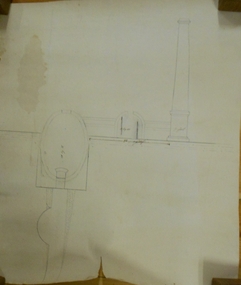
Document - MARKS COLLECTION: PLAN OF CHIMNEY STACK
Unlabeled plan, drawing shows side view of chimney stack, '5 feet' written on base of chimney. Plan could be associated with a mine on New Chum Reef Line, Victoria Hill.bendigo, mining, chimney side section, chimney stack -
 Bendigo Historical Society Inc.
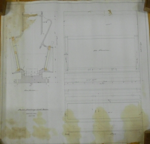
Plan - MARKS COLLECTION: DOUBLE DISCHARGE GOLD MORTAR
Plan drawn on buff paper, written on plan 'double discharge gold mortar' - no mine name given. Engineering drawings of gold mortar. 3 inches = 1 foot, September 1879.mining, equipment, lansell mine ? -
 Bendigo Historical Society Inc.
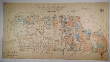
Map - SPRING PLAINS, Examined 31/01/1876
Map: Parish of Springplains, County of Dalhousie. Parish plan June 1874 A.D. Scott Examined E.D. 4.7.74 Additions made March 1877 Written in blue " See new plan."map, dalhousie, parish plan, spring plains, a. d. scott -
Lakes Entrance Historical Society
Book, Perrott Lyon Mathieson Pty. Ltd, Lake Tyers Beach and Surrounds Strategy Plan, 1991
A commissioned study of the Lake Tyers Beach and surrounding area prior to future planning with regard to urban development, tourism and conservation of natural beauty. Contains illustrations and a plan of proposed boat ramps.waterfront, township, tourism -
 Bendigo Historical Society Inc.
Book - LESSON PLANS AND WORK PROGRAM, 27/7/1954 - 18/11/1955
Book, Lesson plans and work program books.The lesson plans book is a large book bound by two screws through front and back heavy cardboard which is covered in black material.The plans range from 20/7/1954 to 18/11/1955.They cover a lot of local schools in the Bendigo area.book, bendigo, education -
 Bendigo Historical Society Inc.
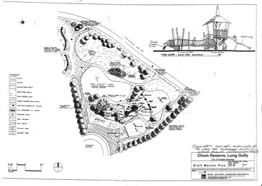
Document - LONG GULLY HISTORY GROUP COLLECTION: CHUM RESERVE LONG GULLY
Copy of a plan of the Chum Reserve, Long Gully, dated September 1998. The plan between Derwent Drive and Dyason Court show play area, trees, swings, fire pit, tree house and grassy area. There is also a plan of the tree house - South East Elevation. Drawn by Mary Jeavons Landscape Architects.bendigo, history, long gully history group, the long gully history group - chum reserve long gully, shared action long gully community house, city of greater bendigo, mary jeavons landscape architects -
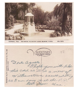 Williamstown Botanic Gardens- Hobsons Bay City Council
Postcard - Williamstown Botanic Gardens, c1900-1920
The original postcards in this series (2013.002 to 2013.018) were generously loaned to Williamstown Botanic Gardens by a private collector for copying. The fountain is located on the southern side of the ornamental lake and was erected to celebrate the jubilee of the municipality (17 March 1906). Controversy surrounded the commission for the design and construction of the fountain, as it was originally assigned to a contractor in Carlton. Williamstown residents insisted the fountain be designed and constructed locally, and on December 1906 the fountain was tendered by local firm Bliss and Sons and opened for public use in 1906. The fountain features a symmetrical plan, consisting of fur granite columns supporting a granite canopy and is fully operational following restoration work in 2013. The idea for the fountain came from an elderly resident of Williamstown who suggested the council follow the example of Ballarat’s gardens with its many statues and monuments. The postcards are evidence of the interest the gardens held as a subject for postcard publishers. The text and images provide a snapshot into fashions, social interests and concerns of the time. The professionally produced images provide a pictorial history of Gardens including changing planting styles, various structures and features of the Gardens eg the aviary, cannons, the fountain, the second Curator’s Lodge and gates. The images offer an opportunity to compare garden vistas with the present day. The significance of the fountain is its reflection of how Williamstown people felt for their Gardens and the importance placed on investing in locally operated business. It was noted in the Brief Jottings column of the Williamstown Chronicle, February 24 1906, the fountain is a “We favor the erection of the jubilee fountain in the Giffard-street (Williamstown Botanic) Gardens. Ornaments of that kind there will make that beauty spot even more attractive.” Sepia scene of a fountain situated on paths bordered with rocks. The fountain in on a plinth and the postcard shows the plaque and two of the four drinking stations. The fountain features a symmetrical plan, consisting of four granite columns supporting a granite canopy. Front: VALENTINE’S, M.355 THE FOUNTAIN, WILLIAMSTOWN GARDENS MELBOURNE, VICTORIA. REAL PHOTO. Reverse: vertical on left side of card and underlined: ‘Published by the Valentine & Sons Publishing Co. Ltd. / Queen St, Melb’. Top centre of card: Contains logo of ‘VALENTINES / REAL PHOTO SERIES’. The postcard is addressed to ‘Dear Agnes’ from ‘Una’. Marked in pencil on to right hand corner ‘1920 / $8’ believed to be put on the postcard by the vendor. postcard, gardens, post-card, williamstown-botanic-gardens, hobsons-bay-city-council, jubilee-fountain, fountain drinking-fountain, 1920, granite, bliss-and-sons, 1906 -
 City of Moorabbin Historical Society (Operating the Box Cottage Museum)
A laminated , photocopy of the ‘Plan of Box Cottage c 1865 ‘, 1985
The original small, pioneer cottage was built in the late 1840s to early1850s, by an unknown pioneer. It was located on part of a 30 Acre allotment that was originally part of Dendy’s Special Survey granted in 1841. The doors and window sashes, (made of red deal joinery timber), as well as the brass locks and fittings, are from the original cottage, and were imported from England. The fire-place bricks are from the original cottage, and are sun-dried, (not kiln fired), and are hand-made. Convict marks can be seen on two bricks. There is a small display of external cladding shingles from the original pioneer cottage. These shingles were hand-split, and most likely made from locally collected timber The nails included in this display were used to fasten the shingles on the original cottage, and are also hand-made. The cottage was occupied by William Box and family from 1865 until 1914 when it was sold to William Reitman who resided there until 1950. The enamel nameplate, “Colonial”, on the wall of the cottage, was the name chosen for the original pioneer cottage by Mr William Reitman, when he purchased the property in around 1915, for 1200 Pounds approximately. In 1974 Mr Lewis, a timber specialist, found the dilapidated building on property he had recently purchased in Jasper Rd and suggested it be reconstructed and relocated. Moorabbin Council agreed and the cottage was rebuilt just about 250 metres from its original site. The cost of the rebuild was met by 'Victoria's 150th Committee, plus a small grant from the City of Moorabbin, and Mr Laurie Lewis donated much of the timber for the reconstruction. The re-constructed cottage plan has followed faithfully the original dimensions, and plan of the original pioneer cottage, and as many original items from that cottage’s long occupation have been incorporated. The photographs in Album 1 record the progress of the reconstruction from February 1984 to the First Public Open Day November 18th 1984Mrs H Deam and Mr A. Smith, CMHS members, photographed the progress of the 'Reconstruction' from February 1984 to November 1984. Although 'Box Cottage' is a re-construction, it is an unique museum that, being located in the midst of a modern community in Ormond Victoria, can educate and demonstrate many aspects of the early settler’s way of life in Victoria. As such, it is an invaluable resource for students and all kinds of visitors. A laminated , photocopy of the ‘Plan of Box Cottage c 1865 ‘ Hand drawn layout of 2 houses with shrubs, trees, plants, wells, gardens on the Box Cottage site c1930 as recalled by Stefanie Rietman Rennick. brighton, moorabbin, cottages, pioneers, ormond, colonial, mckinnon, dendy henry, box william, box elizabeth, reitman william, convicts lewis timber co. ltd., deam h, museums, box alonzo, smith a, -
![Map, [Coornmill land area available for leasing for grazing, Parish of Coornmill]. Circa 1904](/media/collectors/5e461d8021ea67224c82f2a1/items/677cde147f2053f3e5d277c3/item-media/677cdeea7f2053f3e5d27bb4/item-fit-380x285.jpg) Bacchus Marsh & District Historical Society
Bacchus Marsh & District Historical SocietyMap, [Coornmill land area available for leasing for grazing, Parish of Coornmill]. Circa 1904
This map shows an area of land north of Bacchus Marsh in the Larderderg State Park area known as the Parish of Coornmill.The map indicates an area of land which was to be made available by public tender for grazing leaseholders. The plan to do this was discussed in the Bacchus Marsh Express newspaper on the 16 July, 1904, page 2, column 7. The area reserved for grazing leases is identified by red lines on the map. The Express described the area available for grazing was 12,000 acres.A single page paper map showing an area of land in the Parish of Corrnmill to be made available for grazing leases. A photo lithographed Lands Department Map. No scale indicated. The map is pasted into a bound volume containing 76 maps or plans in total. High resolution digital image stored on BMDHS computer network. coornmill parish maps, lerderderg state park maps, agriculture bacchus marsh area -
Federation University Historical Collection
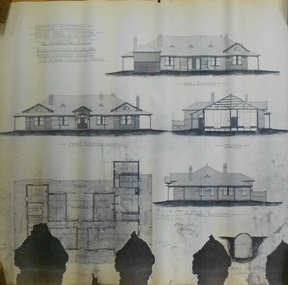
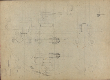
Plan, New Engineering Building for Ballarat School of Mines, 1939, 13/06/1939
.1) West and South Elevations .2) East and North Elecation and floor plan .3) Sections E-F, M-N, O-P, G-H, Z (Excavations and retaining walls) .4) Site plan and details of Retaining Walls .5) Excavations and retaining walls .6) Site Plan and retaining walls chief architect, ballarat school of mines, saw-tooth, engineering, architectural drawing -
![Plan, Improvements on the Camp Reserve Ballarat, 1870, 26/4/1870 (exact); Traced by Henry [Mornes?], district surveyor, on the above date](/media/collectors/4f729f6797f83e0308601707/items/4f72a4fa97f83e0308602508/item-media/59b79d3921ea680200c6b8a7/item-fit-380x285.jpg) Federation University Historical Collection
Federation University Historical CollectionPlan, Improvements on the Camp Reserve Ballarat, 1870, 26/4/1870 (exact); Traced by Henry [Mornes?], district surveyor, on the above date
The Ballarat Camp housed the Goldfields administrators. It was from this site that the troopers left on the morning of 3 December 1854 to attack the Eureka Stockade. Much of the area shown in on the west side of Camp Street is now used by the Federation University Arts Academy.Hand-drawn plan on white linen showing the camp reserve in what is now known Ballarat's Camp Street. The plan shows allotments in an area bounded by Mair, Sturt and Lydiard Streets. The plan has colours indicating wooden buildings, stone buildings, brick buildings, Wood & zinc buildings, and wood & brick buildings.ballarat, camp street, horace walker, henry mornes, goldfields architecture, reserve for public, buildings, goldfields administration, eureka stockade -
 Bendigo Historical Society Inc.
Plan - MARKS COLLECTION: PLAN ALBERT PARK SERPENTINE FOR G. LANSELL
Copy of plan written on top LH corner: Proposed Homestead Albert Park Serpentine for H. Lansell Esq. Scale eight feet to one inch. W. Beebe & G.D. Garvin Architects, late W. Beebe, Mitchell St. Bendigo. Plan shows front, back and side elevation with floor plan for residence.buildings, house, albert park serpentine -
Port Melbourne Historical & Preservation Society
Document - Specification, Metalling and chanelling, Boundary Street South, Graham Street to St Vincents Street, Arthur Victor Heath, Town Clerk et al, 14 Mar 1893
Specifications (Reg. 77.1) and plan (Reg 77.2) for metalling and channelling Boundary Street South [Pickles Street] from Graham Street to St. Vincents Street. Loan works 1893, plan No. 5.A.V. Heath (Town Surveyor):J.J. Bartlett (Mayor)engineering - roads streets lanes and footpaths, town planning, town clerks, mayors, arthur victor heath, james john bartlett -
Port Melbourne Historical & Preservation Society
Plan - Metalling and chanelling, Boundary Street South, Graham Street to St Vincents Street, 14 Mar 1893
Specifications (Reg. 77.1) and plan (Reg 77.2) for metalling and channelling Boundary Street South [Pickles Street] from Graham Street to St. Vincents Street. Loan works 1893, plan No. 5.J.J. Bartlett (Mayor) 14/3/93engineering - roads streets lanes and footpaths, town planning, town clerks, mayors, arthur victor heath, james john bartlett -
Canterbury History Group
Ephemera - 207 Canterbury Road Canterbury, 2003
Real estate advertisement for the sale by auction of shop at 207 Canterbury Road Canterbury on Thursday 27 March 2003. Includes coloured photographs of the exterior and Canterbury Road, floor plans and site plan.canterbury, canterbury road, shops, nomlas house -
 Bendigo Historical Society Inc.
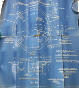
Map - BENDIGO WEEROONA GASWORKS MAP/PLAN COLLECTION: FOUNDATION DETAILS, 1942
Plan: Bendigo Weeroona Gasworks. Plan shows foundation detail 140,000 c. ft. gasholder, Bendigo, 1942. Prepared by N.J. Hurll & Co. ( Vic ) Pty. Ltd., King St., Melbourne.plan, bendigo, bendigo weeroona gas works, gas works -
 Melbourne Tram Museum
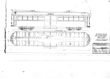
Drawing, Melbourne & Metropolitan Tramways Board (MMTB), "Seating Plan 48 passenger box car (Hopper Windows)", Aug. 1937
Print of drawing R4661, "Seating Plan 48 passenger box car (Hopper Windows)", showing a side elevation and floor plan of a tramcar like a SW6 but with two large central sliding doors.trams, tramways, sw6 class, bogie trams, new tramcars, tramcar construction, proposals -
Port Melbourne Historical & Preservation Society
Document - Report, Ewan Ogilvy's Bayside Papers, Bayside EES Inquiry, Ewan Ogilvy's Bayside Papers, Box One, 1988
Ewan Ogilvy, former Melbourne Councillor and also of Community Services Victoria, Inner Urban Ministerial Advisory Committee and Uniting Church's Centre for Urban Research and Action (CURA), was instrumental in social justice approaches to town planning. He and CURA's Social Justice and the City Project funded Port Melbourne community groups protesting against the SCDC development in 1987. His files were presented to the Society in May 2001 on his preparation for leaving Victoria.From Ewan Ogilvy's chronologically organised 'Bayside Papers' relating to the proposed development of Port Melbourne industrial land in the late 1980s: EES Inquiry report to the Minister for Planning and Environment 7 April 1988, included in bound black file. Appendix 5: Panel's recommendation re site contamination (one page)All items signed 'Ewan Ogilvy'town planning, town planning - proposals shelved - bayside, public action campaigns, environmental issues, ewan ogilvy, centre for urban research and action, sandridge city development co pty ltd, scdc, linton r lethlean, judy arndt, francis b barnes -
Port Melbourne Historical & Preservation Society
Document - Report, Ewan Ogilvy's Bayside Papers, Bayside EES Inquiry, Ewan Ogilvy's Bayside Papers, Box One, 1988
Ewan Ogilvy, former Melbourne Councillor and also of Community Services Victoria, Inner Urban Ministerial Advisory Committee and Uniting Church's Centre for Urban Research and Action (CURA), was instrumental in social justice approaches to town planning. He and CURA's Social Justice and the City Project funded Port Melbourne community groups protesting against the SCDC development in 1987. His files were presented to the Society in May 2001 on his preparation for leaving Victoria.From Ewan Ogilvy's chronologically organised 'Bayside Papers' relating to the proposed development of Port Melbourne industrial land in the late 1980s: EES Inquiry report to the Minister for Planning and Environment 7 April 1988, included in bound black file. Appendix 6: Panel's response to PMCC Counsel Michael Wright 6ppAll items signed 'Ewan Ogilvy'town planning, town planning - proposals shelved - bayside, public action campaigns, environmental issues, ewan ogilvy, centre for urban research and action, sandridge city development co pty ltd, scdc, linton r lethlean, judy arndt, francis b barnes, michael wright - qc, port melbourne city council -
 Federation University Historical Collection
Document, Folio of papers and plans relating to Albert Sutton, Son of Henry Sutton
Henry Sutton is a talented world-wide accepted inventor with inventions relating to the telephone, photography, wireless, cars, motorcycles, and bicycles as well as many more inventions. Henry was also one of four brothers that ran the Sutton's Music Store after the death of their Father Richard Sutton. Henry Sutton taught Applied Electricity at the Ballarat School of Mines in 1883 to 1886.Folio of papers and plans relating to Albert Sutton, Son of Henry Suttonhenry sutton, albert sutton, racv, plans, son of henry -
 Phillip Island and District Historical Society Inc.
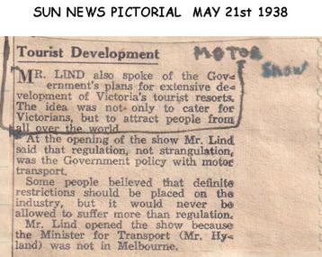
Newspaper clippings, 21/05/1938
Article in Sun News Pictorial 21/05/1938Article on opening of the Motor Show and plans for development of Victoria's Tourist Resorts.local history, documents, newspapers, motor show, black & white newspaper clipping -
 Greensborough Historical Society
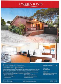
Advertising Leaflet, Darren Jones Real Estate, 3/31 Henry Street Greensborough, 2014
For sale notice for 3/131 Henry Street Greensborough, sold in April 2015 for $360,000Cardboard leaflet, printed in colour both sides, includes floor planhenry street greensborough -
 Greensborough Historical Society
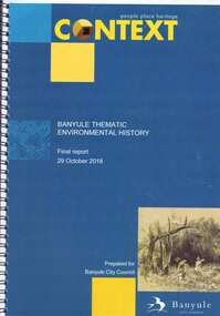
Book, Context (GML Heritage Victoria Pty Ltd), Banyule thematic environmental history: final report, 2018_10
Report on and development of heritage themes relating to forms and places in the City of Banyule area, including places associated with Aboriginal people. Final report prepared for Banyule City Council by Context.82 p., spiral bound, colour and black and white photographs and planscity of banyule, heritage places -
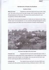 Greensborough Historical Society
Article, Norm Colvin, My memories of Poulter Ave residents, by Norm Colvin, 28/07/2016
Details of the development and occupation of sites in Poulter Avenue and Bicton Street Greensborough, compiled by resident Norm Colvin.12 pages, text, black and white photographs and colour subdivision plan.poulter avenue greensborough, bicton street greensborough -
Glenelg Shire Council Cultural Collection
Plan - Plan - CRB concrete handrail, n.d
Port of Portland Authority Archivesport of portland archives -
Glenelg Shire Council Cultural Collection
Plan - Plans - Machinery, n.d
Port of Portland Authority Archivesport of portland archives