Showing 8487 items
matching snowy-river-dry-cleaners
-
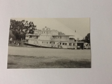 Port of Echuca
Black and white photograph, 21.09.1984
Black and white photograph of the P. S. Gem moored by the river bank. Recorded as being holed on Mildura slip. For statistical on the P. S. Gem see registration no.10 from The River trade, Wool & Steamers by G. Painter , pp.55, 66. Details of the paddle steamer can be located in The Register of Australian & N. Z. Shipping.The P. S. Gem is a large paddle steamer of historical and social significance. It has 3 levels including what appears to be many cabins.Black and white photograph of P. S. Gem moored by river bank. Recorded as being holed on Mildura slip. Copy of an original photograph taken 1954.On reverse of photo in pencil: Gem 1954, holed on Mildure slip.p. s. gem, mildura slip -
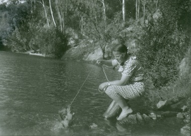 Kew Historical Society Inc
Photograph - Mother and child at the Yarra River, Kew, 1950s
Canoeing on the River Yarra was a recreational traditional pastime for the people of Kew and Melbourne since settlement in the 1830s. Later in the century, canoes were frequently hired from boathouses.Print enlargement. Woman beside river holding a piece of string. Child swimming in Yarra. Canoe in distance beside bank with passengers.Reverse: "M Holmes"recreation -- canoeing, yarra river -- kew -
 Lakes Entrance Historical Society
Photograph - Zephyr, 1940 c
Also a second black and white photograph of Peels launch Zephyr in Tambo River with Swan Reach bridge in background 05099.1Black and white photograph of Peels launch Zephyr filled with passengers moored at landing place on Tambo River near bridge at Swan Reach Victoriaboats and boating, tourism -
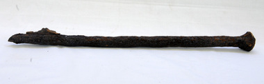 Orbost & District Historical Society
bridge spike
This spike came from the old Brodribb River bridge which is about 9.6 kilometres from Orbost. The Brodribb River joins the Snowy River north of Marlo. In 1906, a bridge replaced the punt over the Brodribb River, improving communication with Orbost. It was eventually replaced by a reinforced concrete bridge built by the Road Construction Authority in 1989 where the Princes Highway passes over the Brodribb RiverThis item belongs to a significant local structure which has been replaced.A very rusty iron bridge spike from the old Brodribb Bridge.brodribb-river bridge-spike -
 Mont De Lancey
Knife Cleaner/Sharpener, Circa 1910
Combination cast iron static knife cleaner and sharpener, with cork between two cast iron pieces.knife cleaners, knife sharpeners -
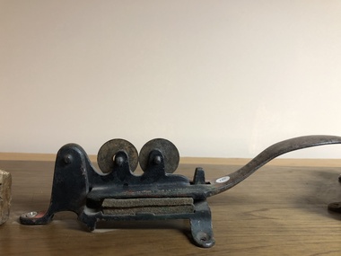
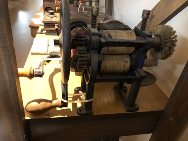 Mont De Lancey
Knife Cleaner, Peckett's, Circa 1890
'Peckett's No. 2' Cast iron, hand-cranked twin rubber roller knife cleaner, with a wooden handle."Peckett's Blackpool" -
 Mont De Lancey
Knife Cleaner, 19th Century
Oak cased static type knife cleaner, with 2 brass labels, bearing Royal Coat of Arms."Fourdriniers" on brass labelsknife cleaners -
 Sunbury Family History and Heritage Society Inc.
Photograph, 27 June 1934
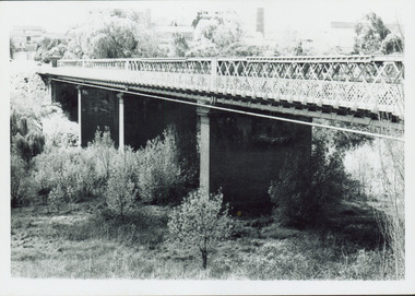
This is a photograph of the bridge in the Bulla township which spans the Deep Creek, a tributary of the Maribyrnong River. It has been constructed from bluestone which is found across the volcanic western plains in Victoria. Kaolin was quarried from the cliff face in the background and was used in the making of bricks and pottery products manufactured at Northcote and Brunswick potteries.This is one of the many notable bluestone bridges which were built in the district in the nineteenth century.A black and white photograph of a valley with a five arched bridge spanning a river. There are high cliffs in the background.bulla township, deep creek, bridges -
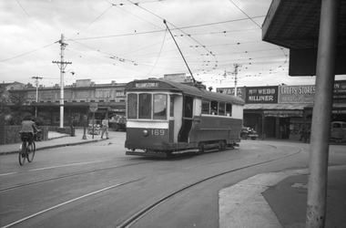 Melbourne Tram Museum
Negative, Wal Jack, 21/04/1945 12:00:00 AM
Black and white negative, by Wal Jack, of S 169, Williamstown Road turning from Irving St into Nicholson St over the railway line. In the background are Malvern Cycles, a frock shop, Footscray Fish Shop, Bancroft's Dry cleaners, Moran and Cato, Miss Webb Milliner, Crofts Grocery, A I Brown delivery truck, tram stop sign, fire alarm and a road "Major Stop Road".trams, tramways, footscray, nicholson st, irving st, williamstown road, s class, tram 169 -
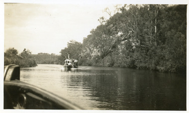 Lakes Entrance Historical Society
Photograph - Tambo River, 1950 c
Road between Swan Reach and Tambo Upper follows river bank opposite cliffsBlack and white photograph print showing tourist launch, possibly 'MV Blackbird' on Tambo River below the cliffs, taken from another boat. Tambo Upper Victoria waterways, boats and boating, tourism -
 Marysville & District Historical Society
Photograph (item) - Black and white photograph, Unknown
An early black and white photograph which shows a man and a woman standing on the bridge that crosses the Steavenson River at the base of the Steavenson Falls in Marysville in Victoria.An early black and white photograph which shows a man and a woman standing on the bridge that crosses the Steavenson River at the base of the Steavenson Falls in Marysville in Victoria. The Steavenson Falls are named after the Victorian Assistant Commissioner of Roads and Bridges, John Steavenson who arrived in Victoria in the early 1860s.steavenson river, steavenson falls, marysville, victoria, waterfalls, john steavenson -
 Kew Historical Society Inc
Photograph - Outer Circle Railway Viaduct
The heritage listed Fairfield Bridge was originally constructed for the Outer Circle Railway to bridge the Yarra River between East Kew and Fairfield stations. In the 1930s it was converted for vehicular traffic. In the 2010s a new concrete bridge was erected beside it to increase vehicular capacity.Print copy, enlarged from original snapshot, of the former railway viaduct crossing the Yarra and linking Kew and Fairfield. The original photo predates the conversion of the viaduct into the Chandler Highway Bridge in the 1930s, when the Bridge was adapted to carry vehicular traffic. The date on the reverse indicates the date of donation rather than the date on which the photograph was taken. CHANDLER HIGHWAY BRIDGE OVER RIVER / (ORIGINALLY PART OF OUTER CURCLE RAILWAY) / OCTOBER 1977railway viaduct -- kew (vic.), fairfield bridge, fairfield railway viaduct, outer circle railway, sir john monash -
 Kew Historical Society Inc
Photograph - Crossing Dights' Falls on the Yarra by foot
Dight’s Falls in Studley Park is an artificial weir built on a natural rock bar across the Yarra. The weir was built in the 1840s to provide water to the ‘Ceres’ flour-mill, one of the first in Victoria. The falls were later to become known as Dight’s Falls after the owners of the mill. Later, a pumping station was built on the Kew side of the river, which pumped water uphill to a reservoir in Walmer Street that provided water to the Melbourne Botanical Gardens and to Albert Park Lake. The area around Dight’s Falls was and is frequently used for recreational activities.Rare original print photograph of people walking across Dight's Falls when the river flow was low. View west towards Abbotsford. Photograph taken from Kew side of river above the Falls.Reverse: "M Holmes"dight's falls, river yarra -- kew - abbotsford -
 Port of Echuca
Photograph, Approx.1980s
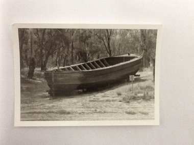
The barge 'Ada' was built in Echuca in 1899. It was 33 metres in length and 6.9 metres wide and was made from timber and iron. It's design was unique as it was half-timber, and half-iron- the iron featured above the water line to prevent the wool bales from getting wet. The 'Ada' was used to carry wool from sheep stations on the Murray and Murrumbidgee Rivers down to Echuca Wharf for distribution around the world. The Permewan Wright, Murray Shipping Company, owned the 'Ada' and in the1930s the barge was sold to the Evans family who used it to transport timber to it's Echuca sawmill. The 'Ada' was purchased by the Port of Echuca in 1974 and is seen here on the Moama slipway undergoing restoration for Port of Echuca in 1979 to 1980. The remains of the 'Ada' still lie on the banks of the Moama slipway but it has fallen into near complete disrepair.The barge 'Ada' is very significant due to the uniqueness of her design. The hull is timber, up to the water line, then iron from the water line up to protect the bales of wool bales that it transports from water damage. The P.S Pevensey, within the Port of Echuca collection, has the same design feature.The barge 'Ada' in dry dock, on a slipway with a 4 knot marine sign is next to it. The barge is surrounded by trees and has since fallen into disrepair. Verso: 'Ada Barge'murrumbidgee river, wool, ada, murray river, barges, evans saw mills, timber industry, port of echuca, echuca wharf, permewan wright co. -
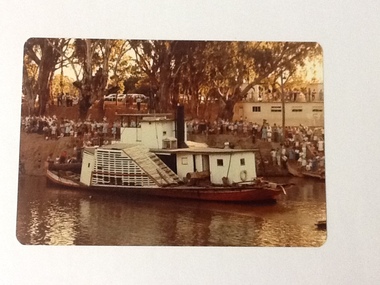 Port of Echuca
Colour Photograph, 04/03/1983
Colour photograph of the P. S. Adelaide in the river, with the port side of the boat clearly visible. The bank behind and the roof of the boat shed at Paddlewheel park are lined with spectators. Final part of the photo sequence of the event no.:P000041; P000045; P000046; P000047; P000048 of the P. S. Adelaide re-floating.The re-floating of the P. S. Adelaide was a Significant community social event evident by the number of spectators in the photograph. The community had invested a great deal of time and money into re-floating the paddlesteamer. The newspaper covered the event in detail with a number of action shots as the boat made its rear entry from the temporary slipway onto the river. Part of a photo sequence no.P000041; P000045; P000046; P000047; P000048 of P. S. Adelaide re-floating.Colour photograph of P. S. Adelaide on the Murray river at Echuca after her re-floating. The port side of the Adelaide is clearly visible. The banks of the river are lined with spectators. The pontoon boat shed at Paddlewheel Park is visible on the right, also has spectators on the roof platform.p. s. adelaide, re-floating p. s. adelaide, echuca -
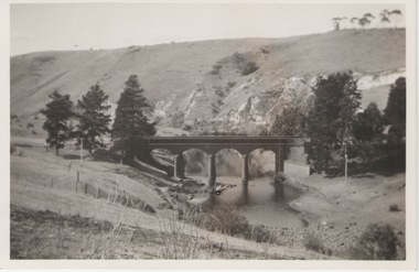
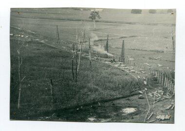 Orbost & District Historical Society
black and white photograph, 1916
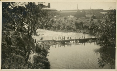
This photograph shows the pile drivers at work in the construction of the viaduct across the Snowy River flats. The Snowy River Floodplain Railway Bridges, two sequential and exceptionally long and low timber railway bridges on the Snowy River floodplain just west of Orbost, were built in 1916, and provided the original terminus point for the Bairnsdale-Orbost railway. The bridges are 770 metres and 183 metres long respectively. The shorter bridge is of uniformly 4.57 metre timber-beam construction, and has a sweeping curve in its deck. The longer bridge has a combination of 4.57 metre and 6.1 metrespans, and two 3.66 metre spans. The bridges are constructed from 'Southern Mahogany', Eucalyptus Botryoides, which grew along the coast east of Bairnsdale. The Snowy floodplain bridges were initially built in the context of an early twentieth-century interest in American-style 'Developmental Railways', designed to open remote areas to closer settlement, even if that meant running at a loss. The line was closed in August 1987. (information from Victorian Heritage Database)This item is associated with the history of the Orbost-Bairnsdale railway line and therefore reflects the role that the rail line played in the social and economic history of Orbost.A black / white photograph of the farming flats at Orbost during the construction of the East Gippsland railway.orbost-railway east-gippsland-railway viaduct-orbost transport railway -
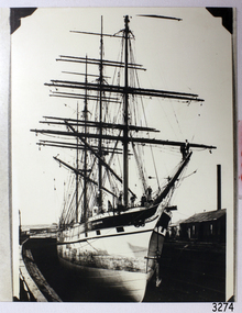 Flagstaff Hill Maritime Museum and Village
Photograph
Black And White photograph of Loch Broom, in Dry Dock.flagstaff hill, warrnambool, shipwrecked-coast, flagstaff-hill, flagstaff-hill-maritime-museum, maritime-museum, shipwreck-coast, flagstaff-hill-maritime-village, photograph, loch broom -
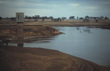 Bendigo Historical Society Inc.
Slide - VAL DENSWORTH COLLECTION: DRY LAKE EPPALOCK, May 2004
Slide. Dry Lake Eppalock. The water tower at the Lake.slide, bendigo, dry lake eppalock., dry lake eppalock. -
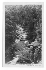 Marysville & District Historical Society
Postcard (item) - Black and white postcard, Rose Stereograph Company, Talbot Drive, Marysville, Vic. No. 4, View from Murray Pass, 1913-1967
An early black and white photograph of the view of the Taggerty River from Murray Pass near Marysville in Victoria.An early black and white photograph of the Taggerty River from Murray Pass near Marysville, Victoria. Murray Pass is located on the Lady Talbot Drive. Lady Talbot Drive a 24 kilometer scenic rainforest car journey which passes a number of walks and waterfalls in the Yarra Ranges National Park. Lady Talbot Drive is named after Lady Sarah Elizabeth, the wife of Sir Reginald Talbot, who was the Governor of Victoria from 25th April, 1904 to 6th July 1908. This postcard was produced by the Rose Stereograph Company as a souvenir of Marysville.POST CARD The "Rose" Series/ De Luxe A Real Photograph/ Produced in Australia Published by the Rose Stereograph Co./ Armadale, Victoria. Dear Harold/ This is the prettiest card I/ could get for you. Probably we will/ go this trip in a day or two./ Yours Nance xxx xxxmarysville, victoria, photograph, taggerty river, murray pass, lady talbot forest drive, 2309, postcard, souvenir, lady talbot drive, sir reginald talbot, sarah elizabeth talbot, rose series postcard -
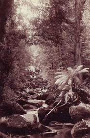
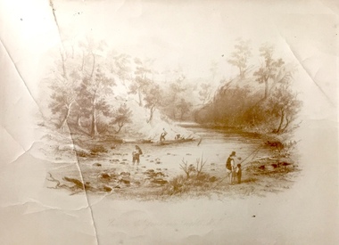
![Scene Near the Buffalo Mountains / [by] Nicholas Caire, circa 1876](/media/collectors/550653872162f11fb04854aa/items/57826074d0cdd1176ce5bcc1/item-media/578260d1d0cdd1176ce5f61a/item-fit-380x285.jpg) Kew Historical Society Inc
Kew Historical Society IncPhotograph, Anglo-Australasian Photographic Company, Scene Near the Buffalo Mountains, c. 1876
Nicholas Caire was born on Guernsey in the Channel Islands in 1837. He arrived in Adelaide with his parents in about 1860. In 1867, following photographic journeys in Gippsland, he opened a studio in Adelaide. From 1870 to 1876 he lived and worked in Talbot in Central Victoria. In 1876 he purchased T. F. Chuck's studios in the Royal Arcade Melbourne. In 1885, following the introduction of dry plate photography, he began a series of landscape series, which were commercially successful. As a photographer, he travelled extensively through Victoria, photographing places few of his contemporaries had previously seen. He died in 1918. Reference: Jack Cato, 'Caire, Nicholas John (1837–1918)', Australian Dictionary of Biography.An original, rare photograph from the series 'Views of Victoria: General Series' by the photographer, Nicholas Caire (1837-1918). The series of 60 photographs that comprise the series was issued c. 1876 and reinforced a neo-Romantic view of the Australian landscape to which a growing nationalist movement would respond. Nicholas Caire was active as a photographer in Australia from 1858 until his death in 1918. His vision of the Australian bush and pioneer life had a counterpart in the works of Henry Lawson and other nationalist poets, authors and painters.‘Scene near the Buffalo Mountains’ : Views of Victoria (General Series) No.41 : Albumen silver photograph | Photo on card with Title and Description on reverse | Mounted 24 x 30 cm; Photo 12 x 17 cm.On Reverse: ‘This scene is taken from the banks of the Buckland River, which is about five miles distant from the Buffalo Mountains, as seen in the distance. These mountains are frequently covered with snow, in consequence of their great altitude. The Buckland River is a small tributary of the Ovens River, which flows through the Beechworth district, and eventually finds its way to the River Murray. The Bridge which is seen on the right of the picture forms the roadway which leads from the Buckland Camp to the Township of Bright.’nicholas caire (1837-1918), landscape photography -
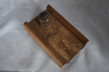 Warrnambool and District Historical Society Inc.
Functional object - Knife and fork cleaner, Levin & Co Pty Ltd, Early 20th century
This is a simple household labour-saving device. The box was fitted to the end of the table and knife polish was sprinkled on the cloth inside. The knife was then placed in the centre of the box and clamped in tightly. The knife was then pulled backwards and forwards several times (three seconds was the suggested time) and the object was then deemed to be polished. All households had cutlery of some sort and many had good silver pieces that were meant to be kept in a sparkling polished condition. This cleaner would have assisted those in a household assigned to the care of the cutlery. These would have included the women of the household, the children or domestic employees. This item is retained as an interesting example of a household labour-saving device from 100 years ago. This is a circular wooden box with an extra piece at one end of the base and a sliding top lid with a wooden knob. The lid lifts up and the inside of the box and the lid is covered with rough cloth. Some of this cloth has rotted away. The top of the lid has a printed label pasted on. This is torn and soiled. ‘Patent The Magic Knife and Fork Cleaner’ ‘I am handy and useful where’r I am used, To clean knives and forks brightly I never refuse, In mansion or cottage to both I do go, So buy me, and try me, my worth you will know.’ household devices, history of warrnambool -
 Whitehorse Historical Society Inc.
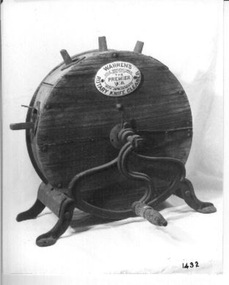
Tool - Knife Cleaner
Wooden round container on metal legs with a metal handle to turn it with. It has a number of holes in which to place cutlery. It is filled with a carborundum and appears to have leather straps to distribute the carborundum which cleans the cutlery.On an enamelled plate on the side ' Warren's Rotary Knife Cleaner- Sole manufacturer'domestic items, cutlery -
Glenelg Shire Council Cultural Collection
Accessory - Grooming Tools, n.d
Displayed in History House in cut glass pen holder (3821)a. nail file b. nail file c. cuticle cutter d. nail cleaner e. button hookgrooming, manicure, personal care -
 Mont De Lancey
Knife Cleaner, Circa 1895
Hand cranked, 2 3/4" diameter rotary disc, combination knife cleaner/sharpener/polisher-buff."Harras"knife cleaners, knife polishers, knife sharpeners -
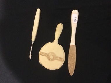 Mont De Lancey
Manicure set, Addis
Three piece manicure set including - Nail file, nail cleaner and small hand mirror with bird etching.manicure equipment, nail files, hand mirrors -
 Ballarat Tramway Museum
Photograph - Black and White - tram 36 Bridge St, A T Miles, 27/11/1969
Black and White - tram 36 (Victoria St), at Stones Corner, picking up 6 passengers. The man is carrying a Gladstone bag. The photo is looking west and has a Top 4 dry cleaners shop sign in the background. Taken by A T Miles 27/11/1969. The photo likely to have been taken before a 48-hour strike by SEC workers that commenced on that day. See item 8774. Yields information about services to Victoria St.Photograph - black and white print with notes on rear. A T Miles stamp and location and date notes.tramways, trams, stones corner, victoria st, bridge st, passengers -
 Kew Historical Society Inc
Photograph - Dight's Falls, 1920s
Dight’s Falls in Studley Park is an artificial weir built on a natural rock bar across the Yarra. The weir was built in the 1840s to provide water to the ‘Ceres’ flour-mill, one of the first in Victoria. The falls were later to become known as Dight’s Falls after the owners of the mill. Later, a pumping station was built on the Kew side of the river, which pumped water uphill to a reservoir in Walmer Street that provided water to the Melbourne Botanical Gardens and to Albert Park Lake. The area around Dight’s Falls was and is frequently used for recreational activities.One of a series of photographs, probably taken by Henry Christian of the Yarra River in Kew. An item from an outstanding and diverse photographic collection, assembled by members of the Christian and Washfold families of Kew.River Yarra at Dight’s Falls, Kew/Fairfield photographed from Kew bank.dight's falls, river yarra, christian-washfold collection -
 Kew Historical Society Inc
Print, View on the Yarra Near Dights Falls, Nineteenth Century
The original book plate reflects the colonial use of the River Yarra fro both recreation and industry.View on the Yarra Near Dights Falls. Reproduction of a book plate from an original wood engravingg, showing men and boys on the banks of the River Yarra. The activities represented include logging and fishing. Annotation on reverse: [Original] "Caption: View on the Yarra Near Dights Falls."yarra river, dights falls -
Port Melbourne Historical & Preservation Society
Document - Short Road Ferry ticket, c.1974
From the collection of Warren DOUBLEDAY. The Short Road ferry ran between the end of Williamstown Road in Port Melbourne across the narrowest section of the Yarra River to the bottom of the Strand in Williamstown. The name came from it being the 'short road' between the two places. There was a type of ferry service in operation from around 1873 which was modernised in the 20th century to take cars and trucks across the river. It was operated by two heavy chains which sank to the river bed to allow ships to pass.A single trip 15 cent ticket for crossing the Yarra River from Williamstown on the Short Road Ferry. The off white ticket has two diagonal blue stripes and the number P016322 printed on the side. transport - ferries, short road ferry, williamstown, transport - motor vehicles -
Port Melbourne Historical & Preservation Society
Document - Short Road Ferry ticket 1974, 7 Jan1974
From the collection of Warren DOUBLEDAY. The Short Road ferry ran between the end of Williamstown Road in Port Melbourne across the narrowest section of the Yarra River to the bottom of the Strand in Williamstown. The name came from it being the 'short road' between the two places. There was a type of ferry service in operation from around 1873 which was modernised in the 20th century to take cars and trucks across the river. It was operated by two heavy chains which sank to the river bed to allow ships to pass.A single trip 20 cent ticket for crossing the Yarra River from Williamstown on the Short Road Ferry. The off white ticket has two diagonal blue stripes and the number C049655 printed on the side. On reverse side of ticket -" 8.25 pm trip. 7-1-74 (last East bound for day'"transport - ferries, short road ferry, williamstown, transport - motor vehicles