Showing 12177 items
matching the well
-
 Greensborough Historical Society
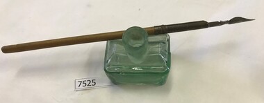
Container - Ink Bottle, J. Angus, 1900s
Ink bottle; with top removed, served as ink well. The bottle was designed with an enclosed top for transport, which would be removed prior to use (shear top).Green glass cabin ink bottle, shear top, with "Post office" nib pen, shear top, molded textJ. Angus ink bottles, inkwells, nib pens -
 Eltham District Historical Society Inc
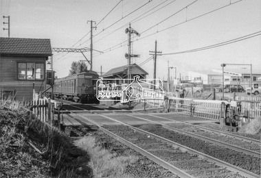
Photograph, Tait (Red Rattler) train bound for Mordialloc at McKinnon Road level crossing, Mckinnon Railway Station, Frankston line, c.1970, 1970
The level crossing is the old McKinnon Rd. level crossing right at Mckinnon Railway Station on the Melbourne-Franston line. It no longer exists as the level crossing was amongst the first to be removed in the State Govt. grade separation programme c 2015. The line now runs under Mckinnon Rd in a cutting that holds the new station as well. The folding metal lattice gates were the only ones of their kind in Victoria and fairly rare anywhere else in Australia as well. Digital TIFF file Scan of 9 x 13 cm black and white printfrankston line, mordialloc, red rattler, tait train, mckinnon road, level crossing, mckinnon railway station -
 Kew Historical Society Inc
Plan - Camberwell Panorama Estate, 1923
Subdivision plans and real estate flyers/brochures reveal a number of aspects of urban development and history. The Kew Historical Society's collection of these plans, as well as advertisements extracted from magazines, cover key aspects of community development and architectural history of Kew and Kew Eat as well as surrounding suburbs. While most of the plans in the collection were gifted to the Society by the former City of Kew, a number of other plans and advertisements have been donated by individuals, of which this is an example.Promotional brochure for the Camberwell Panorama Estate. The four page bifold handout advertises 216 home sites bounded by Bulleen Road, The Nook, Fortuna Avenue, and Doncaster Road. Other streets in the subdivision include: Sunburst Avenue, The Moor, and Macedon Avenue. The brochure has been damaged at some time in the past and so masking tape obscures the tram on page 1. Page 2 includes the plan of the subdivision, page 3 information about the site and a locality plan, while page 4 includes photographs and terms of sale. subdivision plans -- balwyn north (vic.), camberwell panorama estate -
Kew Historical Society Inc
Plan - Tramway Estate, Camberwell North, 1937
Subdivision plans and real estate flyers/brochures reveal a number of aspects of urban development and history. The Kew Historical Society's collection of these plans, as well as advertisements extracted from magazines, cover key aspects of community development and architectural history of Kew and Kew Eat as well as surrounding suburbs. While most of the plans in the collection were gifted to the Society by the former City of Kew, a number of other plans and advertisements have been donated by individuals, of which this is an example.Single page subdivision plan listing properties for sale in the Tramways Estate, Camberwell North. The large estate was bounded by Doncaster Road, Burke Road, Marwan Avenue, Maud Street, Severn Street, and extended over Glass's Creek at Mayland's Avenue. Within the plan, lots 3 to 342 are listed as lots. The plan includes annotations in ink indicating the prices realised by a number of lots. A key explains that lots with an 'H' represent a house, whereas the 37 shaded lots represent those being offered by this agent. subdivision plans -- camberwell (vic.), tramways estate -
Kew Historical Society Inc
Plan - Subdivisional Sale of 11 Villa Sites, East Kew, 1939
Subdivision plans and real estate flyers/brochures reveal a number of aspects of urban development and history. The Kew Historical Society's collection of these plans, as well as advertisements extracted from magazines, cover key aspects of community development and architectural history of Kew and Kew Eat as well as surrounding suburbs. While most of the plans in the collection were gifted to the Society by the former City of Kew, a number of other plans and advertisements have been donated by individuals, of which this is an example.Single page residential subdivision plan advertising house lots for sale, in what was then designated as East Kew but is now Kew, in the following streets: Burke Road, Enfield Street. The flyer includes a smaller locality plan at right. Information on the flyer indicates that the land was previously owned by the Melbourne & Metropolitan Tramways Board.subdivision plans -- kew (vic.), enfield street -- kew (vic.), burke road -- kew (vic.) -
Kew Historical Society Inc
Booklet - Old Kew Golf Links Estate, 1926
Subdivision plans and real estate flyers/brochures reveal a number of aspects of urban development and history. The Kew Historical Society's collection of these plans, as well as advertisements extracted from magazines, cover key aspects of community development and architectural history of Kew and Kew Eat as well as surrounding suburbs. While most of the plans in the collection were gifted to the Society by the former City of Kew, a number of other plans and advertisements have been donated by individuals, of which this is an example.8-page brochure advertising 80 residential home sites for sale in a subdivision called the 'Old Kew Golf Links Estate'. These sites had historic importance in Kew's history as they had previously belonged to Kodak Pty Ltd who were refused permission by Kew Council to use the land for industrial development. The estate, advertised was advertised as being within five miles of Melbourne. The brochure is notable as it includes photographs of Kew East Primary School, the former Kew Golf Club clubhouse, and 'The Moorings' Boathouse (aka Chipperfield's Boat House). The aerial photograph, overlaid with names of notable sites, on the final page is of interest as it shows the area before the intrusion of the Eastern Freeway, which resulted in changing the course of a section of the Yarra River. old kew golf links estate, subdivision -- kew (vic.), subdivisions -- kew east (vic), chipperfield's boathouse, kew east primary school, kew golf club -
Kew Historical Society Inc
Plan - Charteris Estate, Ivanhoe [East], 1927
Subdivision plans and real estate flyers/brochures reveal a number of aspects of urban development and history. The Kew Historical Society's collection of these plans, as well as advertisements extracted from magazines, cover key aspects of community development and architectural history of Kew and Kew Eat as well as surrounding suburbs. While most of the plans in the collection were gifted to the Society by the former City of Kew, a number of other plans and advertisements have been donated by individuals, of which this is an example.Original 4-page bifold handout advertising 43 residential lots for sale in the Charteris Estate subdivision in Ivanhoe [now classified as Ivanhoe East]. This brochure was created to sell the third section of the estate which it labels as 'The Most Superb Section'. Streets within the subdivision include: Burke Road North, McArthur Road, Castella Street, and the Government Boulevard. In addition to the overall plan spread across pages 2 and 3, each page includes a number of interesting photographs including: a number of the new Burke Road Bridge, a sports ground, Hoyts Picture Theatre in Ivanhoe, a croquet ground, and Ivanhoe shopping centre [named Motor Cross Junction].charteris estate - east ivanhoe (vic), subdivision plans -- ivanhoe east (vic.), d.c. mcarthur, charterisville -
Kew Historical Society Inc
Plan - Burke Road Junction Estate, East Kew, 1940
Subdivision plans and real estate flyers/brochures reveal a number of aspects of urban development and history. The Kew Historical Society's collection of these plans, as well as advertisements extracted from magazines, cover key aspects of community development and architectural history of Kew and Kew Eat as well as surrounding suburbs. While most of the plans in the collection were gifted to the Society by the former City of Kew, a number of other plans and advertisements have been donated by individuals, of which this is an example.Original 4-page bifold brochure advertising the Burke Road Junction Estate in Kew East. Advertised for sale in 1940, the estate comprised 16 'Central Allotments' fronting High Street, Kilby Road, and Glass Street. Pages 1 & 4, the front and back covers, includes a panoramic photograph of the junction which features a number of shops still extant, but also with buildings long demolished and redeveloped. These include the petrol station and the dairy on the southeast and southwest corners of Burke Road and High Street/Doncaster Road. The dairy includes a statue of a cow on its roof. Pages 2 & 3 include a detailed plan of the estate. subdivisions -- kew east (vic.), burke road junction estate -
Kew Historical Society Inc
Plan - Willsmere Park Estate, Kew, 1926
Subdivision plans and real estate flyers/brochures reveal a number of aspects of urban development and history. The Kew Historical Society's collection of these plans, as well as advertisements extracted from magazines, cover key aspects of community development and architectural history of Kew and Kew Eat as well as surrounding suburbs. While most of the plans in the collection were gifted to the Society by the former City of Kew, a number of other plans and advertisements have been donated by individuals, of which this is an example.Original 4-page, bifold subdivision plan of the Willsmere Park Estate, Kew. The 1926 land sale advertised '40 superb villa allotments' on the 'Yarra Heights'. Streets within the subdivision included: Willow Grove, Kilby Road, Elm Grove and Belford Road. The double page spread on pages 2 and 3 shows the detailed plan of the 40 lots, surrounded by public parkland [Willsmere Park] and the Kew Golf Links. By the time that this version of the plan was released, only the lots on Willow Grove and Kilby Road remained. willsmere park estate -- kew (vic.), subdivisions - kew (vic.), subdivisions -- kew east (vic.), willsmere park -- kew east (vic.) -
Kew Historical Society Inc
Plan - 30 Choice Home Sites in Kilby Road, Meldrum Street and Fairway Drive, 1965
Subdivision plans and real estate flyers/brochures reveal a number of aspects of urban development and history. The Kew Historical Society's collection of these plans, as well as advertisements extracted from magazines, cover key aspects of community development and architectural history of Kew and Kew Eat as well as surrounding suburbs. While most of the plans in the collection were gifted to the Society by the former City of Kew, a number of other plans and advertisements have been donated by individuals, of which this is an example.Original 4-page, bifold brochure, one of two in the collection, of home sites created following the creation of the Eastern Freeway which separated a section of land owned by the Kew Golf Club from the main course. The new estate featured 30 lots in Meldrum Street, Kilby Road and Fairway Drive.subdivisions -- kew east (vic.), subdivisions -- kew (vic.), kew golf club -
Kew Historical Society Inc
Plan - 30 Choice Home Sites in Kilby Road, Meldrum Street and Fairway Drive, 1965
Subdivision plans and real estate flyers/brochures reveal a number of aspects of urban development and history. The Kew Historical Society's collection of these plans, as well as advertisements extracted from magazines, cover key aspects of community development and architectural history of Kew and Kew Eat as well as surrounding suburbs. While most of the plans in the collection were gifted to the Society by the former City of Kew, a number of other plans and advertisements have been donated by individuals, of which this is an example.Original 4-page, bifold brochure, one of two in the collection, of home sites created following the creation of the Eastern Freeway which separated a section of land owned by the Kew Golf Club from the main course. The new estate featured 30 lots in Meldrum Street, Kilby Road and Fairway Drive. subdivisions -- kew east (vic.), subdivisions -- kew (vic.), kew golf club -
Kew Historical Society Inc
Booklet - Yarraleen Estate, Bulleen, c.1966
Subdivision plans and real estate flyers/brochures reveal a number of aspects of urban development and history. The Kew Historical Society's collection of these plans, as well as advertisements extracted from magazines, cover key aspects of community development and architectural history of Kew and Kew Eat as well as surrounding suburbs. While most of the plans in the collection were gifted to the Society by the former City of Kew, a number of other plans and advertisements have been donated by individuals, of which this is an example.Original 8-page booklet advertising a new residential development in Bulleen entitled 'Yarraleen'. The glossy multi-colour brochure includes historic and contemporary photographs of the Yarra Valley, graphic designs of potential residential development, photographs of key facilities (Marcellin College, Golf links, local swimming holes, the Beaver Swim School, Carey Grammar School Oval and grandstand, shopping strips, and farmland).subdivisions -- bulleen (vic.), yarraleen estate -
Kew Historical Society Inc
Flyer - 45 Pakington Street, Kew
Subdivision plans and real estate flyers/brochures reveal a number of aspects of urban development and history. The Kew Historical Society's collection of these plans, as well as advertisements extracted from magazines, cover key aspects of community development and architectural history of Kew and Kew Eat as well as surrounding suburbs. While most of the plans in the collection were gifted to the Society by the former City of Kew, a number of other plans and advertisements have been donated by individuals, of which this is an example.Single page illustrated real estate flyer advertising 45 Pakington Street, Kew for sale by auction. Annotation in pen and ink at rightpeter neville, real estate advertisements -- kew (vic.), 45 pakington street -- kew (vic.) -
Kew Historical Society Inc
Flyer - 60 Pakington Street, Kew
Subdivision plans and real estate flyers/brochures reveal a number of aspects of urban development and history. The Kew Historical Society's collection of these plans, as well as advertisements extracted from magazines, cover key aspects of community development and architectural history of Kew and Kew Eat as well as surrounding suburbs. While most of the plans in the collection were gifted to the Society by the former City of Kew, a number of other plans and advertisements have been donated by individuals, of which this is an example. Single page illustrated flyer, advertising 60 Pakington Street, Kew for sale. Annotation in pen and ink at right.neville collection, 60 pakington street -- kew (vic.), real estate advertisements -- kew (vic.) -
 Flagstaff Hill Maritime Museum and Village
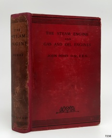
Book - Reference, John Perry, The Steam Engine and Gas and Oil Engines, 1899
This is the first edition of the book, printed in 1899. It has since been reprinted with slight corrections in January 1900 and with correction in 1902. It is a text book and reference book based on the study of steam, gas and oil driven machinery of the late 19th and early 20th century. The author, John Perry D. Sc., F.R.S., was born in 1850 and passed away in 1920. He was a Professor of Mechanics and Mathematics in the Royal College of Science, Vice-President of the Institution of Electrical Engineers, and Vice-President of the Physical Society. This book has significance as the First Edition of the book, published in 1899. The book is significant to the history, understanding and evolution of power driven machines. The principles apply to the machinery of the late 19th to early 20th centuries. The Steam Engine and Gas and Oil Engines: a book for the use of students who have time to make experiments and calculations Author: John Perry D.Sc., F.R.S. Publisher: Macmillan & Co Ltd, London Printed by Richard Clay and Sons, Limited, London and Bungay This is the First Edition of the book, printed in 1899 A hard cover book, red linen with black print. The Preface is written by the aughor on 22nd February 1899. The book contains many diagrams and tables as well as having reference numbers on many paragraphs in the chapters.Pencil on front endsheets "SJ 9""Rec. 371 a" Stamped in purple , front endsheet "F. ST. G. D. HOLYMAN" "L.4." Handwritten in ink "Richard G ---- / Liverpool --- P---ye"warrnambool, shipwrecked-coast, flagstaff-hill, maritime-museum, shipwreck-coast, book, the steam engine and gas and oil engines, john perry, reference book, scientific book, steam engines, gas engines, oil engines, combustion engines -
 Bendigo Military Museum
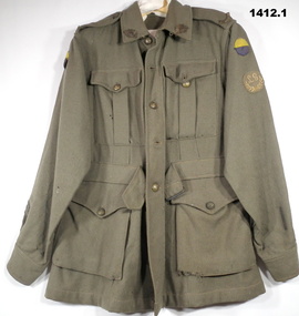
Uniform - JACKET AND SLOUCH HAT - WW1, Dalter Lucas & Sons (1910) Ltd, 1918
Slouch hat and Uniform jacket belonging to Edwin James JONES No 3511 AIF. Refer 1367.5 for his service history. The hat was manufactured in 1918 by Dalter Lucas & Sons Bury, UK. It appears to be of a similar style to those issued to Gurkha troops due to the thickness of the felt, the three rows of stitching around the brim and the use of a press stud to pin up the left hand side of the brim..1) Coat, Battle Dress, Kahki, includes 2 x “Australia” shoulder badges, 2 x “Rising Sun” epaulette badges, 2 x “yellow over purple” colour patches, 3 x “service chevrons”, 1 x “Empire Wounded stripe”, 1 x “Lewis Gun” cloth badge, all metal buttons intact as well as waist belt. .2) Hat, Slouch, kahki fur felt, cotton pugaree, leather head band, Rising sun badge, no chin strap..2) Pressed into the hat band appears to be; “Dalter Lucas & sons (1910) Ltd, BURY 1918”uniforms, military clothing, costume accessories - male -
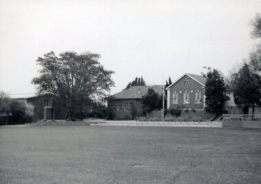 Camberwell Girls Grammar School
Photographs - original, Circa 1965
Collection of 21 black and white and 3 colour photographs taken approximately in 1965 of the School buildings and grounds. Views of the Oval with classrooms and J.G. Robinson Hall located near the well-loved fig tree. View of J.G. Robinson Hall and the P.W. Oval taken from the 1955 second storey addition to the Woodstock building. Exterior and interior views of the Woodstock Building including interior views of the science laboratory opened in 1960. The J.G. Robinson Hall was used for a variety of events including assemblies; gymnasium and performances. -
 Kew Historical Society Inc
Plan - Subdivision Plan, Corsewall Estate, 1938
The Kew Historical Society collection includes almost 100 subdivision plans pertaining to suburbs of the City of Melbourne. Most of these are of Kew, Kew East or Studley Park, although a smaller number are plans of Camberwell, Deepdene, Balwyn and Hawthorn. It is believed that the majority of the plans were gifted to the Society by persons connected with the real estate firm - J. R. Mathers and McMillan, 136 Cotham Road, Kew. The Plans in the collection are rarely in pristine form, being working plans on which the agent would write notes and record lots sold and the prices of these. The subdivision plans are historically significant examples of the growth of urban Melbourne from the beginning of the 20th Century up until the 1980s. A number of the plans are double-sided and often include a photograph on the reverse. A number of the latter are by noted photographers such as J.E. Barnes.The Corsewall Estate was a subdivision, bordering on Barkers Road and Auburn Road, which created Corsewall Close. This relatively late subdivision included 29 allotments. The subdivision plan includes the dimensions of each lot as well as the width of the existing and projected roads and turning circles. The Corsewall Close Precinct is now listed on the Victorian Heritage Database (HO147) and is noted for its ‘consistent flat-type development over the entire street, which has been cleverly designed to make multi-unit dwellings appear as single buildings’.subdivision plans - hawthorn, corsewall estate -- hawthorn (vic.) -
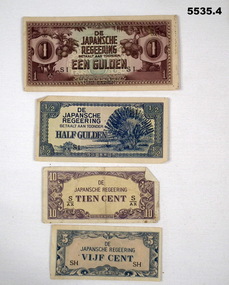 Bendigo Military Museum
Currency - JAPANESE INVASION MONEY, Japanese Government, c1939-1945
Refer to RAAF service of No.40595 C.S. Cornelius.This is a set of Japanese Invasion money notes in 4 values; 1. EEN Gulden - medium size note, front is printed in brown and green ink. The rear is printed in brown ink. 2. This is a small note of 1/2 Gulden, white paper with blue ink on front. rear side is in blue ink as well. 3. This is a small note of Tien cent. Printed in purple ink on both sides. 4. This is a very small note - 5 cent (VIJF). Printed in blue ink on both sides.ww2, dutch east indies, invasion money -
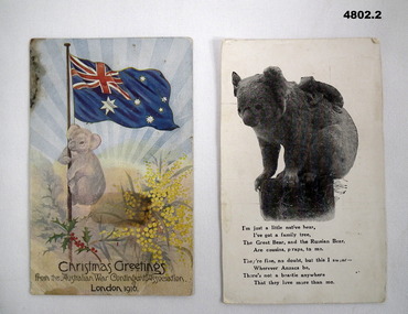 Bendigo Military Museum
Postcard - CHRISTMAS GREETING POSTCARDS, KOALA MOTIF, Australian War Contingent Assoc, 1916
1. On the rear the letter is written in ink. It's addressed as "Dear Susie.../from your loving brother Joe" Undated buts it's hot in Australia. 2.1, Colour printed postcard. It shows a Koala up a flag pole. Australian flag on top. There are sprigs of wattle and holly. At bottom is stamped "From the Australian War contingent Association. London 1916. 2. Black and white photo of Koala and cub. A poem i sprinted at the bottom on the rear, written in ink is a short message to Dear Susie ..........From Your Loving Bro, Joe. (He states he is "still alive and well! Addressed to Miss S Stuart, Serpentine Via Inglewood, Vicpostcards, ww1, family -
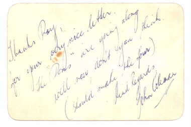 Essendon Football Club
Thank you card, 1954
Cards were sent by John Coleman in response to letters of support received after he injured his knee in 1954. He never played again. Thank you card on cream cardboard with rounded corners and message in calligraphy script printed in blue ink; message reads: "Sincere thanks for your kind expressions of Sympathy and Good-will during my recent football injury. I can asssure you it is deeply appreciated. John Coleman." Handwritten message in blue ink on back of card reads: "Thanks, Ray, for your very nice letter. The "Dons" are going along well now, don't you think. (Should make the four). Kind regards, John Coleman. essendon football club, john coleman -
 Ararat Gallery TAMA
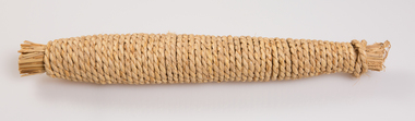
Functional object, Dried salted fish, c. 1900s
‘The Art of the Japanese Package’ was an exhibition that toured to 10 Australian and 11 New Zealand public galleries in 1979 and 1980. The touring exhibition comprised 221 objects of traditional Japanese packaging which extended from ceramics, wood and paper to woven fibre containers. At the conclusion of the tour, The Japan Foundation and the Crafts Board of the Australia Council donated the vast majority of the exhibition to the Ararat Gallery for its permanent collection. Combining the natural qualities of bamboo, paper and straw with delicate craftsmanship, these unique objects express Japanese aesthetics as applied through fibre crafts. In Japan, the qualities and traits of natural materials are exploited rather than hidden. The texture of straw, the septa of bamboo are not concealed but lovingly incorporated into the whole. In 1979 Hideyuki Oka, curator of ‘The Art of the Japanese Package’ wrote: “In no way self-conscious or assertive, these wrappings have an artless and obedient air that greatly moves the modern viewer. They are whispered evidence of the Japanese ability to create beauty from the simplest products of nature. They also teach us that wisdom and feeling are especially important in packaging because these qualities, or the lack of them, are almost immediately apparent. What is the use of a package if it shows no feeling?” The descriptions of the featured objects were written by Hideyuki Oka, curator of ‘The Art of the Japanese Package’, 1979.Gift of the Japan-Australia Foundation and the Crafts Board of the Australia Council, 1981Here a whole dried and salted fish (a yellow tail, to be exact) has been wrapped in a sheath of straw and wound with a continuous length of straw rope. The effect is attractively rustic, and the tightly wound rope makes a pleasing pattern. When the fish is to be eaten, it is necessary only to unwind the rope part of the way, slice off as much as is needed, and then close the package by rewinding. This rope-wound yellowtail, makiburi, as the Japanese call it, is a well-known product from the city of Kanazawa, Ishikawa Prefecture, in the Sea of Japan. - Professor Hideyuki Oka, curator.japanese art, japanese packaging, tsutsumi, gift giving -
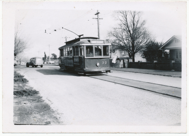
 Ballarat Tramway Museum
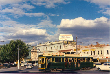
Photograph - Colour Photograph/s, 1962?
Colour postcard size print of an SEC Bendigo Bogie tram at Charing Cross. Photo undated, but could be 21.11.1962. Printed on AGFA paper. Tram fitted with dash canopy lighting, but no large white strip under the driver's windows. Photo out of focus. Has a SEC roof ad and another ad on the roof, non SEC. In background are the various buildings along Pall Mall. Tram well loaded with passengers. Can see the Ezywalkin, The Beehive and large a Mobilgas sign. Two copies held.bendigo, pall mall, charing cross -
 Ballarat Tramway Museum
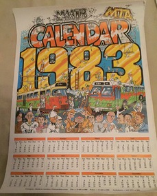
Document - Calendar, Cartoon by Augustine, "MTA 1983", 1982
Single sheet colour calendar for 1983, published by the Metropolitan Transit Authority (MTA), successors to the Melbourne and Metropolitan Tramways Board. Large portion of the calendar features the changeover from the MMTB to the MTA - eg green colours replacing the orange. Also on the base of the cartoon by Augustine is a number of caricatures of well known MMTB/MTA personnel. On top of the calendar has the letters M&MTB being demolished and those of the MTA being positioned. Printed on heavy cartridge paper. Image added 21-1-2016tramways, trams, melbourne, mmtb, mta, calendar -
 Wodonga & District Historical Society Inc
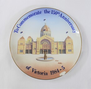
Ceramic - Ceramic Plate Commemorating the 150th Anniversary of Victoria 1984-5
The ceramic plate commemorates the 150th anniversary of the State of Victoria, with an original painting of the Royal Exhibiton Building in Melbourne on the front, by the Victorian artist Charles McCubbin (1930-2010). Charles McCubbin was the grandson of the Australian painter Frederick McCubbin (1855-1917). The ceramic plate commemorating the 150th anniversary of the State of Victoria has state and national signifcance as one of 5000 plates worldwide released by the Moliver Collection. It also has artistic signifcance as there is an original painting of the Royal Exhibition Building in Melbourne on the front, by the well known Victorian artist Charles McCubbin, who was the grandson of the renowned Australian painter Frederick McCubbin.Blue and pink toned circular ceramic plate commemorating the 150th anniversary of Victoria in 1984-5. Front: An original painting of the Royal Exhibition Building in Melbourne, signed by the artist Charles McCubbin, with an inscription around the top and bottom edges. Chip in the edge of the ceramic below the date 1984-5. Back: Text about the plate commemorating the 150th anniversay of Victoria with an original painting by Charles McCubbin and his signature, as well as the Plate No. 0404 and trade marks of the Moliver Collection, Westminster Fine China, Australia and Victoria 150.Front: "To Commemorate the 150th Anniversary / of Victoria 1984-5" - around the top and bottom edges of the plate. "Charles / McCubbin" signature above the date 1984-5. Back: "The Official Plate Commemorating / Victoria's 150th Anniversary. / Officially endorsed by the Victorian Government / and the 150th Anniversary Board. This plate is one / of a limited edition of 5,000 plates worldwide released / by The Moliver Collection / Original painting by Charles McCubbin." - on the upper part of the back of the plate. "THE MOLIVER / Victoria 150 Years / COLLECTION" - on the centre of the back of the plate. "M / THE MOLIVER COLLECTION - on the proper left side of the back of the plate. "Charles McCubbin" - signature in the central part of the back of the plate. "FINE CHINA / Westminster / AUSTRALIA" - on the proper right side of the back of the plate. "Plate No. 0404" - on the lower proper left side of the bakc of the plate "VICTORIA 150 / GROWING TOGETHER 1984-5" - on the lower central part of the back of the plate.victoria 150 years, charles mccubbin, commemorative ceramics, royal exhibition building, the moliver collection, westminster fine china, victoria 150 -
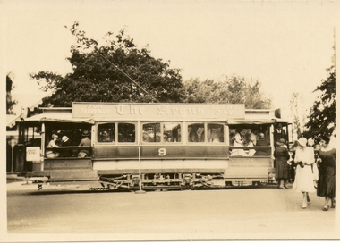
 Ballarat Tramway Museum
Photograph - Digital image, Wal Jack, 29/06/1955 12:00:00 AM
Yields information the appearance of the SEC tramcar No. 30 and the Mt Pleasant tram terminus during the reconstruction of the bridge over Canadian Creek.Digital image from the Wal Jack Ballarat Album of No. 30 at the Barkly St terminus, Mt Pleasant, 29-6-1955. Wal has the album notes of "standby car". Was provided to enable the service in Barkly St during the reconstruction of the Canadian Creek bridge during June-July 1955, see Reg Item 5157 as well and 5301, 5302 and 5305. See image i2 for rear of photograph. See image i3 for hi res scan of print. See image i4 for hi res scan of negativeon rear of photo in ink, "SEC Ballarat, No. 30 at Barkly St terminus (out of use). Mt Pleasant 29-6-55" In the top right hand corner is the W.Jack stamp but no negative number.trams, tramways, mt pleasant, barkly st, canadian creek, tram 30 -
 Ballarat Tramway Museum
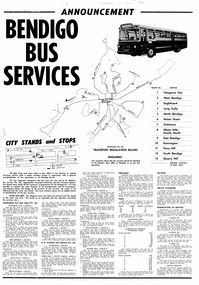
Poster, Transport Regulation Board, Bendigo Bus Services", Feb. 1972
Yields information about the closure of the Bendigo Tramway system and the bus replacements made by the Transport Regulation Board, can be compared to that for BallaratDigital print of a scanned Poster, titled "Bendigo Bus Services" printed on white paper. Produced shortly before the closure of the State Electricity Commission of Victoria operated Bendigo Tramway system. Gives details of the replacement bus services as well as the existing bus services and other changes planned. Provides notes on the operator, timetables, fares, route numbers and dates when the services would be changed. Map shows the bus routes, route numbers, section points and City stands and stops. Authorised by the Transport Regulation Board. trams, tramways, bendigo, map, closure, buses -
 Ballarat Tramway Museum
Photograph - Digital image, c1926
Yields information about an ESCo tramcar ex Sydney tramways in Ballarat and the way passengers were managed c1926.Digital image of a photograph held by David Critchley of Ballarat ESCo No. 9, possibly at the Gardens, Kiosk in the background. Has passengers getting off on the "wrong side". All the passengers are well dressed, indicating attending a possible event. The tram has a roof advertisement for "The Argus" newspaper. Is the sign by the tram a "Safety Zone" sign? Provided by David Critchley - not to be reproduced without discussions with David. David's notes indicates c1926. See also Reg Item 6101 and 5435 for other images of a six window tramcar. trams, tramways, esco, wendouree parade, tram 9 -
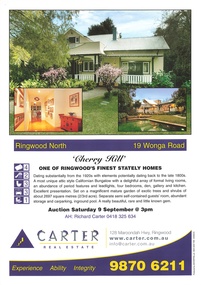 Ringwood and District Historical Society
Memorabilia - Booklet, Real Estate history of "Cherry Hill", 19 Wonga Road, Ringwood North, with property titles and subdivision plans of the 35 acres in the triangle bounded by Oban, Wonga and Warrandyte Roads
16 plastic pockets containing the history of "Cherry Hill". Titles and subdivision plans of the 35 acres in the triangle bounded by Oban, Wonga and Warranyte Roads, Ringwood North. Multi pocket burgundy coloured spiral binder containing 34 pages of the property history, subdivisions, land titles and photographs of the house, compiled by Richard Carter pre-auction 9 September 2006. Includes architectural descriptions of "Cherry Hill" from original allotment in 1872 to 2006. Also history of well known residents who lived in it. -
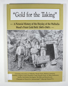 Marysville & District Historical Society
Book - Hardcover book, Gold for the Taking-A Pictorial History of the Heyday of the Walhalla-Wood's Point Gold Belt: 1860's-1960's, 2007
A pictorial history of the heyday of the Walhalla-Wood's Point gold belt in the 1860's-1960'sHardcover. The cover is a gold colour. The front cover has a photograph of a group of miners in front of the entry to a mine. On the top entry timber piece is a sign saying "Old Mine". The beginning of the wording is obscured by one of the miners standing in front of the entry. There is also an old mining trolley standing on tracks which lead into the mine.There is also an old gold mining dish sitting on a rock to the left of the entry into the mine.On the back cover is a photograph of Walhalla in modern times as well as a photograph of the publisher of this book. There is also a blurb about the publisher.Stamp of the Marysville & District Historical Society Inc / P.O. Box 22 / Marysville 3779gold, gold fields, gold mining, a1 mine settlement, aberfeldy, beardmore, black river group, coopers creek, donnellys creek, enochs point, fulton creek, gaffneys creek, gooleys creek, jamieson, jordan valley, kevington, knockwood, matlock, ten mile, walhalla, wood's point, history, victoria