Showing 11008 items matching " land"
-
 Bendigo Historical Society Inc.
Document - H.A. & S.R. WILKINSON COLLECTION: CONTRACT OF SALE
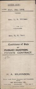
Conditions of sale by private contract dated 21st January 1936 between Mrs. L.M. Billman (seller) and Mrs. H.M. Tarr (buyer) for land situate Church Street Kangaroo Flat being land described in certificate of registration as residence area No. 20818, together with weatherboard dwelling and all sundry. Price 150 pounds.organization, business, h.a. & s.r wilkinson real estate -
 Bendigo Historical Society Inc.
Document - H.A. & S.R. WILKINSON COLLECTION: CONDITION OF SALE
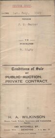
Conditions of sale by private contract dated 1st July, 1929 between J.S. Barker (seller) and R. Rigby (buyer) for land situate No. 81 Harrison Street, Bendigo being land described in certificate of registration as residence area No. 1701, together with 4-roomed weatherboard dwelling and all sundry. Price 135 pounds.organization, business, h.a. & s.r wilkinson real estate -
 Bendigo Historical Society Inc.
Document - H.A. & S.R. WILKINSON COLLECTION: CONDITION OF SALE
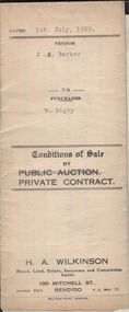
Conditions of sale by private contract dated 1st July, 1929 between J.S. Barker (seller) and R. Rigby (buyer) for land situate No. 81 Harrison Street, Bendigo being land described in certificate of registration as residence area No. 1701, together with 4-roomed weatherboard dwelling and all sundry. Price 135 pounds.organization, business, h.a. & s.r wilkinson real estate -
 Bendigo Historical Society Inc.
Document - JOHANSON COLLECTION: MORTGAGE MRS CATHERINE STUART RICHARDS
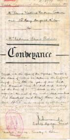
This Indenture, dated 17 March1920 re land at 92 Page Street Albert Park, Annie Westland Hardman Patterson, 607 Ligar Street North Ballarat, executor, and Mary Margaret McNair, Wattle Street Bendigo, executor, in the will of Annie Penistan. Conveyance of land to Mrs Catherine Stuart Richards. Dated17 March 1920bendigo, land sales, patterson, 92 page st a. park, mrs annie westland hardman patterson, mrs mary margaret mcnair, mrs catherine stuart richards. -
 Bendigo Historical Society Inc.
Document - MCCOLL, RANKIN AND STANISTREET COLLECTION: SOUTH NEW CHUM SYNCLINE GOLD MINES, 1932/1934
Documents: envelope contains - 1934 lease 10290, 1936 consent to letting on tribute portions of lease 9903 Bendigo, 1932 contracts etc for land Happy Valley Road, 1932 transfer of Mining lease, 10934 Transfer of Land, 1934 Transfer of lease 10159, 1933 correspondence from Alice Jones re titles.MCCOLL RANKIN AND STANSISTREETorganization, business, gold mining - legal, mccoll rankin and stansistreet, south new chum syncline gold mines. -
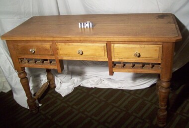 City of Moorabbin Historical Society (Operating the Box Cottage Museum)
Furniture - Table, small hardwood, circa1850
A small, hard-wood table with decorative spindles, three drawers, and turned legs is from the original pioneer cottage built on land that was part of the Dendy's Special Survey 1841 . Now 302 Jasper Road Ormond. The table is in fair condition, but not complete. It is thought that the original drawer handles most likely deteriorated or were broken over the years. An unknown person replaced the original handles with modern glass knobs, in the late 1970’s. This table was in the original pioneer cottage which is now Reconstructed Box Cottage Museum. An unknown pioneer built the Cottage circa 1850 and it was purchased by William Box in 1865. William and Elizabeth Box lived in the Cottage until 1914 when it was sold to August Reitman who resided there until 1950. In 1964 the Cottage was moved to the present site , Joyce Park, adjacent to 302 Jasper Road Ormond A small, hard-wood table with decorative spindles, three drawers, and turned legs is from the original pioneer cottage built on land that was part of the 1841 Dendy's Special Survey The table is in fair condition, but not complete. It is thought that the original drawer handles most likely deteriorated or were broken over the years. An unknown person replaced the original handles with modern glass knobs, in the late 1970’s. moorabbin, table, ormond, bentleigh, pioneer, dendy henry, box william, market gardener, reitman august, dendy special survey -
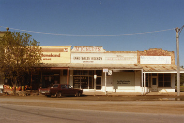 Charlton Golden Grains Museum Inc
Photograph, Charlton Shire, West end Charlton High St c. 1987, c.1987
Shops at the western end, on the south side of High St Charlton showing Eddie Harris Mensland, McKinleys Land Sales Agency, Hillier's Dry Cleaners and Manchester Unity Agency. Built c. 1890s. The tree shops were demolished in early 1990s. The photo was taken by Shire Engineer c. 1987. Part of a series of photos taken by the Shire.Colour photograph of shops at the western end, on the south side of High St Charlton showing Eddie Harris Mensland, McKinleys Land Sales Agency, Hillier's Dry Cleaners and Manchester Unity Agency. Dark cloured car parked in front of McKinleys. Safety flags around tree to the left of the car. Signage in McKinley's window says 'Special Any Garments Only $'. Signage on Hillier's window says Nor-West Laundry & Dry Cleaners.business, industry, eddie harris mensland, charlton, high street -
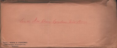
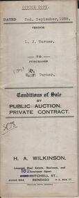 Bendigo Historical Society Inc.
Document - H.A. & S.R. WILKINSON COLLECTION: CONTRACT OF SALE
Conditions of sale by private contract dated 2nd September, 1938 between L.J. Warner (seller) and Mrs. K. Turner (buyer) for land situate No. 28 McClure Street, Bendigo being land described in right to occupy residence area No. 7883, together with 4-roomed weatherboard dwelling and all sundry. Price 260 pounds.organization, business, h.a. & s.r wilkinson real estate -
 Bendigo Historical Society Inc.
Document - H.A. & S.R. WILKINSON COLLECTION: CONDITION OF SALE
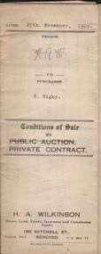
Conditions of sale by private contract dated 25th November, 1929 between H.A. Wilkinson (seller) and R. Rigby (buyer) for land situate corner Bray and Brown Streets, Long Gully, being the land described in miners right as residence area No. 31072, together with 5-roomed weatherboard dwelling and all sundry. Price 95 pounds.organization, business, h.a. & s.r wilkinson real estate -
 Bendigo Historical Society Inc.
Document - H.A. & S.R. WILKINSON COLLECTION: CONTRACT OF SALE
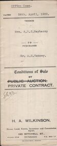
Conditions of sale by private contract dated 24th April, 1935 between Mrs. A.E.J. Mayberry (seller) and Mr. A.E. Ramsey (buyer) for land situate Spring Gully, Bendigo being land described in certificate of registration residence area No. 33215, together with 5-roomed weatherboard dwelling and all sundry. Price 235 pounds.organization, business, h.a. & s.r wilkinson real estate -
 Bendigo Historical Society Inc.
Document - H.A. & S.R. WILKINSON COLLECTION: CONDITION OF SALE
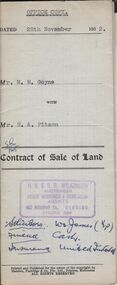
Contract of sale of land dated 28th November, 1952 between Mrs. M.M. Goyne (seller) and Mr. H.A. Pitson (buyer) for land situate No. 140 Lily Street, Bendigo being allotment 21 section 39B described in right to occupy residence area No. 4775, together with weatherboard dwelling and all sundry. Price 1,075 pounds.organization, business, h.a. & s.r wilkinson real estate -
 Bendigo Historical Society Inc.
Document - H.A. & S.R. WILKINSON COLLECTION: CONDITION OF SALE
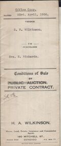
Conditions of sale by private contract dated 23rd April, 1936 between S.R. Wilkinson (seller) and Mrs E. Richards (buyer) for land situate no. 80 Booth Street Golden Square being the land described in right to occupy residence area No. 322, together with 4-roomed weatherboard dwelling and all sundry. Price 220 pounds.organization, business, h.a. & s.r wilkinson real estate -
 Bendigo Historical Society Inc.
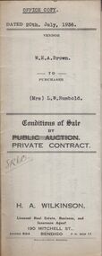
Document - H.A. & S.R. WILKINSON COLLECTION: CONDITION OF SALE
Conditions of sale by private contract dated 20th July, 1936 between W.E.A. Brown (seller) and Mrs L.W. Rumbold (buyer) for land situate in Patrick Street, Bendigo adjoining the vendor's residence, being the unsold portion of the land described in certificate of title volume 5834 folio 1166670. Price 121 pounds 15 shillings.organization, business, h.a. & s.r wilkinson real estate -
 Bendigo Historical Society Inc.
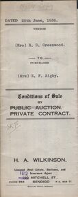
Document - H.A. & S.R. WILKINSON COLLECTION: CONDITION OF SALE
Conditions of sale by private contract dated 28th June, 1938 between Mrs H.D. Greenwood (seller) and Mrs E.F. Rigby (buyer) for land situate No.87 Langston Street, Bendigo, land described in right to occupy residence area No. 179, together with 6-roomed weatherboard dwelling and all sundry. Price 225 poundsorganization, business, h.a. & s.r wilkinson real estate -
 Bendigo Historical Society Inc.
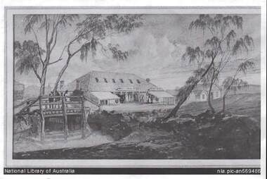
Photograph - BENDIGO POST OFFICE 1854
Photo: copy of photo of first Bendigo Post Office and Survey Office, located corner of Mitchell and Pall Mall. Building constructed by John Pyke, land purchased for 1800 pounds in first land sales. Source of information: Dr. Ralph Birrell. This reproduction is the property of the National Library of Australia, and is not for reproduction in any form apart from for research.bendigo, buildings, post office and survey office -
 Bendigo Historical Society Inc.
Document - TITLE OF LAND AXEDALE
Land title Vol. 3730 Fol. 745810. On the fifth of April Edward Patrick Drake of Axedale hotelkeeper paid 6 pounds for one acre more of less being allotment four of section seven in the town of Axedale, parish of Axedale County. On the other side the names and dates of when the land changed hands up to July 1976.axedale, history, drake family -
 Clunes Museum
Document - TRANSFER OF LAND
.1TRANSFER OF LAND FROM DUNCAN MCLENNAN, TOURELLO TO LACHLAN MCLENNAN, TOURELLO - 2 MARCH 1874 .2 STAT DECLARATION BY LACHLAN MCLENNAN VERIFYING HIS LAND HOLDINGS AND HIS NAME - DATED APRIL 1882 .3 SMALL WHITE PAPER HANDWRITTEN. MCLENNAN FAMILY LINE: LACHLAN - CHRISTOPHER -- ANDREW - GORDON/JOCK - LACHLAN/CHRISTOPHER lachlan mclennan, duncan mclennan -
 Whitehorse Historical Society Inc.
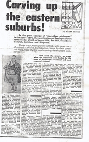
Print - Article, Carving up the Eastern Suburbs, 8/11/1972 12:00:00 AM
Photocopy of book review of Michael Cannon's 'Land Boom and Bust' describing the work of land speculators in the 1880's.Photocopy of book review of Michael Cannon's 'Land Boom and Bust' describing the work of land speculators in the 1880's. The involvement of senior politicians is discussed. Sir Matthew Davies and the Freehold Investment Company in Blackburn and the sale of the Blackburn Park Estate is mentioned. A copy of a Queen's Park, Box Hill 10 pound deposit receipt is illustrated.Photocopy of book review of Michael Cannon's 'Land Boom and Bust' describing the work of land speculators in the 1880's. davies, matthew henry, sir, bent, thomas, benjamin, freehold investment and banking company of australia ltd., blackburn and tunstall property co., queens park estate, box hill, residential development -
 Bendigo Historical Society Inc.
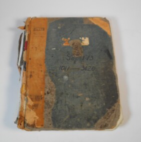
Administrative record - Application for allotments for sale 1908-1974
Green cover book with brown leather spine. The book lists the applications for allotments of land for sale. The headings in the book are: number of application, date of registry, date of application, surname, Christian name and address, parish, allotment, section, area, local land board schedule, classification, crown grant, references and remarks. It covers the years 1908 -1974.Spine has a red label with gold letters. On the cover the remnants of a label, under in ink Sec.173, 1011-3420. At top left of the cover Sec.171 SHland sales, govrnment -
 Bendigo Historical Society Inc.
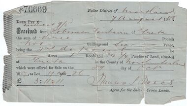
Administrative record - Land purchase records - Maitland NSW, 1888-1889
Northumberland County was one of the original Nineteen Counties in New South Wales and is now one of the 141 Cadastral divisions of New South Wales. The Greta area was first colonized by Europeans around Anvil Creek in the 1830s. When the town was surveyed in 1842 it was given the name Greta, possibly after a small river in Cumberland, England. Coal mining was established in the area in 1862 with the development of a railway station.Robinson Fairbairn Collection: Two documents. 1. Receipt for payment from Robinson Fairbairn of Greta for purchase of land at Greta, NSW. Dated 7th August 1888. Receipt for £3/11/11 includes Interest noted at top. 2. Invoice to Mr. Robinson Fairburn for land purchase in account with Sparke and Clift, Auctioneers, West Maitland. mining, robinson fairbairn collection, maitland, northumberland, greta nsw, sparke and clift, coal -
 Warrnambool and District Historical Society Inc.
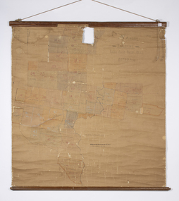
Map - Soldier Settlement Map, Soldier Settlement Commission, Tarrone Estate Alex Boyd, 1940s
This is a map of the Tarrone Soldier Settlement land divisions probably produced by the Soldier Settlement Commission. The map is incomplete with lots 48,49 and 50 missing. The Soldier Settlement Commission purchased 23,373 acres of Tarrone Station from the Boyd brothers in 1947 and the sub divided lots were occupied by soldier settlers commencing in 1949. Tarrone Station was established in 1840 by Doctors Kilgour and Bernard and the Boyd brothers secured the free hold in the 1890s and retained it until 1947. The map hung for many years in the Warrong school near Hawkesdale.This map is of considerable interest as an original item from the establishment of the Tarrone Soldier Settlement..The map is made of brown cloth and creased. The edges are tattered and there is a piece missing at the top. It is a map of allotments, hand drawn and with faded colours in red, blue and yellow. The names of localities and land holders are hand written in ink and chalk. The map is contained within two pieces of wood at the bottom and the top. There are two screws and a cord to hang on a wall. A scale of measurement is shown under the map. tarrone soldiers settlement, boyd brothers tarrone -
 Surrey Hills Historical Society Collection
Photograph, Subdivision sale of Black's Mont Albert farm in 1924, 1924
Photo was taken in 1924 when the land was subdivided. Black's dairy farm occupied the area just east of Hamilton Street to near Elgar Road. It was subdivided into 88 house allotments along Churchill Street, Bruce Street, Black Street, Proudfoot Street and View Street. The solicitors were Proudfoot & Horton, 360 Collins Street; estate agents were Duncan & Weller, 29 Queen Street. The real estate subdivision notice on the SLV website states that Neil Black had been the owner for 50 years. To date no trace of a Neil Black has been found. Box Hill rate books simply give BLACK as the owner in 1877 (no first name); the entry for 1878-1884 states Robert Black. The 1909 electoral roll has entries for Mont Albert Road for Robert Black (farmer), Thomas Black (carter) & Elizabeth Black (HD). The 1912 electoral roll has entries for Mont Albert Road for Robert Black (farmer), Thomas Black (labourer), John Arthur Black (carter) & Elizabeth Black (HD). Robert Black died in 1920 (b. 1836) and is buried in Box Hill Cemetery (CE-*-0057). His parents were John and Margaret Black. He married Lizzie Foley in 1878. She was the daughter of Margaret & John Foley, born in 1859. She died in 1902 aged 43 years and is buried in the same grave, although the cemetery records record her age as 0 years (presumably as no age or date of birth were given at the time of burial). Children: 1. James Hughbert (1880-1954) 2. John Arthur (1881-1959) 3. Alice (1882-1883) - died aged 6 months 4. Laura Elizabeth (1883-1951) 5. Thomas (1885-1965) 6. Isabella (1887-1963) 7. Eleanor (1889-1963) 8. Ada Maud (1890-1968) 9. Robert (1892-1930). BDM Victoria states places of birth as Box Hill, Surrey Hills or Mont Albert. Many of the family are buried in Box Hill Cemetery. None of the girls appear to have married. Communication from a descendant of John Arthur Black gives the following: "John Arthur Black, son of Robert & Lizzie Foley, married Gladys Anne Layton had 4 children, Robert, Elenore, Marion (Follett) & Annie; they had farm on Stud Road, Dandenong where they milked 30 cows that he retired to after being a earth-moving contractor with draft horses and dug irrigation ditches around Shepparton." This is important as documentation of the area's transformation from farming land to residential land use.Black and white photo of a large 3-poled tent in an area of flat land with eucalypts in the background. There is a large crowd of people, mainly men but also women and children. There are also 3 cars to the RHS.black's dairy farm, dairying, farms, churchill street, black street, proudfoot street, bruce street, view street, neil black, proudfoot & horton, duncan & weller, robert black, lizzie black, lizzie foley, james hubert black, john arthur black, alice black, laura elizabeth black, thomas black, isabella black, eleanor black, ada maud black, robert black jnr, box hill cemetery, land sales -
 Bayside Gallery - Bayside City Council Art & Heritage Collection
Photograph, Department of Crown Lands and Survey, Victoria, Melbourne Project: Brighton and Elwood, 1976
The Department of Crown Lands and Survey (1857-1983) was responsible for the administration of survey and mapping and the sale, occupation and management of crown land throughout its existence. This aerial photograph shows parts of Brighton and Elwood and was taken on 1 December 1976brighton, elwood, department of crown lands and survey, aerial photograph, elsternwick park, point ormond, north road, ormond esplanade, st kilda street, glen huntly road, bayside, port phillip bay, map, cartographic material, melbourne project 1976 -
 Orbost & District Historical Society
article, William Morris
GHJ is a journal, produced about every nine - twelve months, for those interested in regional, local and family history in Gippsland, Victoria, Australia. It is compiled by Meredith Fletcher, Debbie Squires and Linda Barraclough and includes a diverse range of articles, both academic and non-academic. Since No.24 it has been a partially refereed journal.(ref kapana)This is a useful research article.A 4 pp article copied from Gippsland Heritage Journal No 30, William Morris on the Threshold of Gipps' Land. The author is Annette Peisley.morris-william genoa-history -
 Federation University Historical Collection
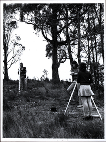
Photograph - Black and white photograph, Surveying Exercise
Two men, and a woman wearing a mini skirt undertake a surveying exercise in a bush location. It is thought to be land near the Mount Helen Campus.surveying, mount helen, mini skirt, platform shoes, desert boots, scientific instruments, student activities -
 Bendigo Military Museum
Memorabilia - PHOTOGRAPH, c.WWII
British Lancaster Bomber releasing bombs over a target. EAW is marked on the side of the bomber . Item re Frederick Gardner DAVEY DFC No 410533 RAAF. Refer Reg No 3536P for his service details.Black / white aerial photo of a British aircraft flying over land partly covered by cloud. A stick of bombs released by the aircraft is visible.On back - Handwritten in blue ink: Stick of bombs going down Stamped: Crown copyright reservedphotography, lancaster, raaf -
 Phillip Island and District Historical Society Inc.
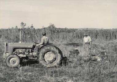
Photograph, Bryant West
One of a collection of over 400 photographs in an album commenced in 1960 and presented to the Phillip Island & Westernport Historical Society by the Shire of Phillip IslandPhotograph of J. Bowman and F. Pickersgill pulling tree stump with tractor and chain, clearing the land for tree planting by Scotch College Boys.local history, photography, photographs, rhyll reserve - land clearing, rhyll reserve, land clearing, tractors, j bowman, f pickersgill, john jenner, bryant west -
Glenelg Shire Council Cultural Collection
Photograph - Photograph - view of Portland, n.d
Photographs taken by Esther Winifred Hall (nee Smallpage) - great grand-daughter of Stephen George Henty. Taken in 1934 Centenary Celebrations in Portland.Black and white photograph showing beach, section of grass land on right foreground, pier and the harbour, a ship at end of pier (centre of image).Front: (no inscriptions) Back: View of Portland to E.W. Hall -, W.A. from Mary Grant - Geralton W.A.esther winifred hall, henty, photography, 1934, centenary, portland -
Glenelg Shire Council Cultural Collection
Photograph - Photograph - Aerial view of the Port of Portland from the south-west, c. 1967
Port of Portland Authority archives.Front: (no inscriptions) Back: Area available for silo extension and storageport of portland archives -
Glenelg Shire Council Cultural Collection
Photograph - Photograph - tug 'Trewalla', n.d
Port of Portland Authority Archivesport of portland archives, tug boat, trewalla