Showing 10473 items
matching plan
-
 Port Melbourne Historical & Preservation Society
Plan - Evans Street from ingles Street to Boundary Street, 1893 - 1919
Plan of Evans Street from Ingles Street to Boundary Street 1893..engineering - roads streets lanes and footpaths -
Port Melbourne Historical & Preservation Society
Plan - Boundary Street from Quinn Street to Evans Street, Engineering Department, Town of Port Melbourne, 1893 - 1919
Plan of Boundary Street from Quinn Street to Evans Street 1893.engineering - roads streets lanes and footpaths -
Port Melbourne Historical & Preservation Society
Plan - Williamstown Road from Farrell Street to Derham Street, 1893 - 1919
Plan of Williamstown Road from Farrell Street to Derham Street 1893.engineering - roads streets lanes and footpaths -
Port Melbourne Historical & Preservation Society
Plan - Rouse Street footbridge, Borough of Sandridge, 6 Oct 1877
Elevation, ground plan and traverse section of Rouse Street footbridge. 1877.Samuel Carter (?) 6/10/1877. Edward Clark (Town Clerk) 6/10/1877.engineering - bridges, sandridge lagoon, edward clark, town clerks -
Port Melbourne Historical & Preservation Society
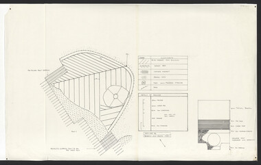
Plan - General Arrangement for gangway at Outer West berth, Station Pier, Port Melbourne, Port of Melbourne Authority, 1987
Plan - General Arrangement - Gangway - Station Pier - Outer West Berthpiers and wharves - station pier, melbourne harbor trust - port of melbourne authority -
Port Melbourne Historical & Preservation Society
Plan - Structural Arrangement for gangway at Outer West berth, Station Pier, Port Melbourne, Port of Melbourne Authority, 1987
Plan - Structural Arrangement - Gangway Outer West Berth - Station Pierpiers and wharves - station pier, melbourne harbor trust - port of melbourne authority -
Port Melbourne Historical & Preservation Society
Plan - Proposed crossing, Rouse Street at Nott Street, George Kelly, Borough Surveyor, 27 Oct 1864
Place of Proposed Crossing in Rouse Street (Corner Nott Street) PlanGeo. Kelly, Cr.(?), Borough Surveyor, Sandridge, 27-10-1864engineering - roads streets lanes and footpaths, george kelly -
Port Melbourne Historical & Preservation Society
Plan - Proposed railway along Howe Parade to Webb Dock, 1973
Plan of proposed railway along Howe Parade to Webb Dock 1973R.C.B. drawing no 7931piers and wharves - webb dock, perce mcguire white, perce white -
Clunes Museum
Plan - TITLE PLAN, DEPT. OF LANDS AND SURVEY, TOWNSHIP OF GLENGOWER
1 PAGE PLAN OF THE TOWNSHIP OF GLENGOWER COUNTY OF TALBOT (11 COPIES) DRAWN AND REPRODUCED AT THE DEPT. OF LANDS AND SURVERY MELBOURNE VICTORIA NOVEMBER 1954 PRICE 2/-parish of glengower, title plan of glengower -
 Queenscliffe Maritime Museum
Plan - Proposed option for housing for the QUEENSCLIFFE, Vacant Council Depot at Queenscliffe, unknown
Queenscliffe lifeboat housing optionOption to house the QUEENSCLIFFEPlan of vacant council depot proposed to house the QUEENSCLIFFE in 2-partsReverse - " nil ".historical references -
University of Melbourne, Burnley Campus Archives
Plan, Horticultural & Experimental Garden in the Survey Paddock Richmond, 1862
Plan of site with area drawn in. From Office Dept. of Natural Resources.Handwritten on it, "To accompany letter from the Hon. Sec. of the Horticultural Society of Victoria to the Hon. The President of the Board of Land Works. A. Purchas, C.E. 9 October 1862 R 19 A1."exprimental gardens, burnley -
University of Melbourne, Burnley Campus Archives
Plan, Phil Tulk, Building 9 and Surrounds Landscape Proposal, 1999
Coloured plan by P. Tulk for AMRAD Corporation 13/8/99phil tulk, buildings -
 University of Melbourne, Burnley Campus Archives
Plan, Lawn Drainage System, 1986
Tracing paper plan dated June 1986 showing details of drainage.drainage, lawns -
 University of Melbourne, Burnley Campus Archives
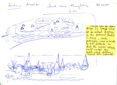
Plan, Geoff Olive, Perennial Border
perennial border, andrew smith, geoff olive -
 Bendigo Historical Society Inc.
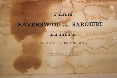
Plan - Robert Moffatt Plan of Estate
A very old plan of the Estate or Robert Moffatt including Ravenswood and Harcourtnumerous numbers in pencilravenswood estate, harcourt, robert moffatt -
University of Melbourne, Burnley Campus Archives
Plan, VCAH Burnley College Swan Street Richmond - Classroom Locations Map, c.1991
2 copies of plan dated c1991. Buildings named, classrooms numbered.vcah, burnley, classrooms -
Bendigo Historical Society Inc.
Plan - MARKS COLLECTION: LEASE PLANS GREAT SOUTHERN GOLD MINE BENDIGO
Plan on heavy paper, tightly rolled. On top of plan Plan of Leases 5429, 4810, 4811 and 5429, The Property of the Great Southern Gold Mining Co. Bendigo' \Total area123 acres, 3 roods, 33 perches, excised, nett area 122, 0. 38. On bottom '32 feet to one inch' and 'This plan was devised from Government Mining Lease Plans and from actual survey' Signed E.F Brown, certificated mining and authorised surveyor 25/6/87' Leases No. 5429 and 4810 details location of shaft, tramway, battery, engine house and boiler. Large mining dam outlined.bendigo, mining, great southern gold mine -
 University of Melbourne, Burnley Campus Archives
Plan, Orchard/Field Station, 1983 - 1992
(3) Used by Linda Hipwell for her Honours Thesis.Plans of the Orchard later known as the Field Station. (1) Copy, "Drawing: Orchard Site Plan." Each section labelled. (2)Tracing paper, 2 paper copies and 3 enlargements, "VCAH Burnley Field Station Plan," some printed labelling and some in pencil. 1992.(3) "VCAH Burnley Field Station Proposed Redevelopment," drawn by MG July 1992. (4) Tracing paper copy, Site Plan of Orchard by Alexander Metherell Pty. Ltd. Job No BHC/1 drawing No SP/2 Dec 1983. Scale 1:500. (5) Plan on tracing paper, includes Energy Education Centre. (6) Plan on tracing paper, includes Energy Education Centre. Scale 1:500. Also see B15.0352 Full Report. orchard, field station, linda hipwell, alexander metherell -
Port Melbourne Historical & Preservation Society
Plan - Ada Mary A'Beckett Free Kindergarten, Fishermans Bend, Martin & Tribe, Architects, 3 Mar 1947
Martin & Tribe - ArchitectsArchitectural plan for the Ada Mary A'Beckett Free Kindergarten and Infant Welfare Centre, Fishermens Bend, 1947. Floor plan, elevations and cross sections. Set number 1 - two pages stapled together.Drawn by J. C. B.education - kindergartens, garden city, built environment - civic, fishermans bend, ada mary a'beckett, martin & tribe, ada mary a'beckett kindergarten -
Port Melbourne Historical & Preservation Society
Plan - Proposed Spring Street elevation, Port Melbourne Town Hall, Arthur Victor Heath, Town Clerk, 10 Dec 1907
Plan of proposal for a new Town hall; front elevation Spring Street; cross section; longitudinal section; side elevation; floor plan. Pen drawings tinted (possibly in water colour) dated 1907Stamped "Surveyor's Office, Town of Port Melbourne":Signed "A.V. Heath 10/12/07"port melbourne town hall, arthur victor heath, town clerks -
Bendigo Historical Society Inc.
Plan - MARKS COLLECTION: PLAN FOR NEW ENTRANCE VESTIBULE TO FORTUNA VILLA FOR GEO. LANSELL ESQ
plan for new entrance vestibule to Fortuna Villa for George Lansell Esq. coloured plan detailing new entrance vestibule and open recess across the verandah, and entry steps RHS of page damaged/ torn -
University of Melbourne, Burnley Campus Archives
Plan, Burnley Horticultural College Students Amenities Building, 1992
First Floor - SRC Office/Furniture. Changes in plan No C2980 02/03/1972. 1:50. All messurements (sic) in cm. and according to original floor plan! 04/03/1992. johnsdorfer.amenities, students, vcah, burnley, john s dorfer -
 Bendigo Historical Society Inc.
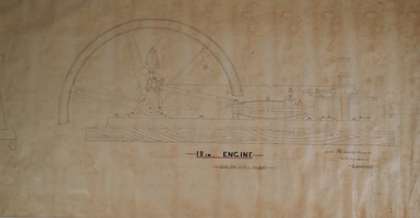
Plan - HORWOOD COLLECTION: DRAWINGS FOR CONSTRUCTION OF 18'' ENGINE
Engineers plan for an 18 '' engine. Written on bottom 'J. Horwood and Sons, Engineers, Sandhurst. 18 IN Engine, Scale one inch = one foot' Plan drawn in fine black pen on waxed paper.bendigo, industry, horwood, foundry, mining equipment -
Whitehorse Historical Society Inc.
Document, Joan Hornabrook
Life Governorship Certificate for Joan Hornabrook, from the Free Kindergarten Union of Victoria, 29 June 1978.Life Governorship Certificate for Joan Hornabrook, from the Free Kindergarten Union of Victoria, 29 June 1978. With letter from Meg Hornabrook outlining Joan Hornabrook's association with the Forest Hill Residential Kindergarten, and a plan of the Kindergarten's vegetable garden.Life Governorship Certificate for Joan Hornabrook, from the Free Kindergarten Union of Victoria, 29 June 1978. forest hill residential kindergarten, hornabrook, joan, free kindergarten union of victoria -
 Kew Historical Society Inc
Plan - Subdivision Plan, J R Mathers & McMillan, Glenferrie Road, Cotham Road, Belmont Avenue, Stirling Street, 1910-1930
Pru Sanderson, in her groundbreaking ‘City of Kew Urban Conservation Study : Volume 2 - Development History’ (1988), summarised the periods of urban development and subdivisions of land in Kew. The periods that she identified included 1845-1880, 1880-1893, 1893-1921, 1921-1933, 1933-1943, and Post-War Development. These periods were selected as they represented periods of rapid growth or decline in urban development. An obvious starting point for Sanderson’s groupings involved population growth and the associated economic cycles. These cycles also highlighted urban expansion onto land that was predominantly rural, although in other cases it represented the decline and breakup of large estates. A number of the plans in the Kew Historical Society’s collection can also be found in other collections, such as those of the State Library of Victoria and the Boroondara Library Service. A number are however unique to the collection.The Kew Historical Society collection includes almost 100 subdivision plans pertaining to suburbs of the City of Melbourne. Most of these are of Kew, Kew East or Studley Park, although a smaller number are plans of Camberwell, Deepdene, Balwyn and Hawthorn. It is believed that the majority of the plans were gifted to the Society by persons connected with the real estate firm - J. R. Mathers and McMillan, 136 Cotham Road, Kew. The Plans in the collection are rarely in pristine form, being working plans on which the agent would write notes and record lots sold and the prices of these. The subdivision plans are historically significant examples of the growth of urban Melbourne from the beginning of the 20th Century up until the 1980s. A number of the plans are double-sided and often include a photograph on the reverse. A number of the latter are by noted photographers such as J.E. Barnes.A ‘proposed’ subdivision of the area in the vicinity of Cotham and Glenferrie Roads and Belmont Avenue depicts an alternate vision for how the land might be divided into lots. When comparing this undated proposed subdivision with a modern map, it is possible to see why the subdivision did not eventuate. The right-of-way shown in the plan as beginning in Belmont Avenue was to be extended much further, preventing the lower lots from being created in the proposed shapes. Identifying the date of the name change may assist in the dating of the proposed subdivision. In faded writing at the top of the plan is an annotation referring to ‘Abbotsford’ and Finlayson’s Agency.subdivision plans - kew, glenferrie road, cotham road, belmont avenue, stirling street -
 Kew Historical Society Inc
Plan - Subdivision Plan, Normanby Estate, East Kew, 1913
Pru Sanderson, in her groundbreaking ‘City of Kew Urban Conservation Study : Volume 2 - Development History’ (1988), summarised the periods of urban development and subdivisions of land in Kew. The periods that she identified included 1845-1880, 1880-1893, 1893-1921, 1921-1933, 1933-1943, and Post-War Development. These periods were selected as they represented periods of rapid growth or decline in urban development. An obvious starting point for Sanderson’s groupings involved population growth and the associated economic cycles. These cycles also highlighted urban expansion onto land that was predominantly rural, although in other cases it represented the decline and breakup of large estates. A number of the plans in the Kew Historical Society’s collection can also be found in other collections, such as those of the State Library of Victoria and the Boroondara Library Service. A number are however unique to the collection.The Kew Historical Society collection includes almost 100 subdivision plans pertaining to suburbs of the City of Melbourne. Most of these are of Kew, Kew East or Studley Park, although a smaller number are plans of Camberwell, Deepdene, Balwyn and Hawthorn. It is believed that the majority of the plans were gifted to the Society by persons connected with the real estate firm - J. R. Mathers and McMillan, 136 Cotham Road, Kew. The Plans in the collection are rarely in pristine form, being working plans on which the agent would write notes and record lots sold and the prices of these. The subdivision plans are historically significant examples of the growth of urban Melbourne from the beginning of the 20th Century up until the 1980s. A number of the plans are double-sided and often include a photograph on the reverse. The Normanby Estate, which was adjacent to Normanby Road, Kew East, included thirty-one lots for sale. Streets on the subdivision plan include Adeney Avenue, Park Hill Road, Normanby Road, Weir Street and Wharton Street. Cotham Road and its tramway are shown nearby. The plan is interesting as it shows Wharton Street, named after the architect and town planner George Wharton, who was the first chairman of the Municipality of Kew. The street was to later be renamed Cecil Street. Also shown are proposed ‘Municipal Gardens’ where Parkhill Drive is now located.subdivision plans - kew, normanby estate -
Whitehorse Historical Society Inc.
Article, Ensuring Link with History, 1991
In 1988 Nunawading Council purchased the historic Matheson orchard.In 1988 Nunawading Council purchased the historic Matheson orchard. Its history goes back to the 1880's when established by John Fankhauser. Council plan an enviromental program on the property providing an overnight experience on the property for children.In 1988 Nunawading Council purchased the historic Matheson orchard.orchards, charles matheson, city of nunawading, matheson mary, fankhauser john -
Glenelg Shire Council Cultural Collection
Plan - S.S Admella Model Plans, n.d
Photocopy of sale/rigging plan of S.S Admella scale 1:48. Photocopy on parchment style paper. Plan used by 'float-a-boat' model markers for the construction of the Admella model acquired by Grant District council.admella, portland lifeboat, 150th anniversary -
Bendigo Historical Society Inc.
Plan - MARKS COLLECTION: PLAN GARDEN FRONT FORTUNA VILLA SANDHURST - G. LANSELL ESQ., JULY 3RD 1871
Plan for construction of Fortuna Villa, Sandhurst Title: Garden Front, Fortuna Villa, Sandhurst for G. Lansell Esq. Dated: 3rd July 1871 Coloured plan and elevation Condition: water damage and paper tears -
NMIT (Northern Melbourne Institute of TAFE)
Architectural drawings and plans NMIT Libraries 1989-2010, Architectural drawings and plans NMIT Libraries1989-2010
Architectural drawings and plans for NMIT Libraries at various campuses, dating from 1987 but most are 2007-2010, including Floor plans, Elevations, Site Plans, Redevelopment plans.nmit, architectural drawings, building plans, library,