Showing 3468 items
matching collection -- kew historical society
-
 Kew Historical Society Inc
Plan, Melbourne & Metropolitan Board of Works : Borough of Kew : Detail Plan No.1568, 1905
The Melbourne and Metropolitan Board of Works (MMBW) plans were produced from the 1890s to the 1950s. They were crucial to the design and development of Melbourne's sewerage and drainage system. The plans, at a scale of 40 feet to 1 inch (1:480), provide a detailed historical record of Melbourne streetscapes and environmental features. Each plan covers one or two street blocks (roughly six streets), showing details of buildings, including garden layouts and ownership boundaries, and features such as laneways, drains, bridges, parks, municipal boundaries and other prominent landmarks as they existed at the time each plan was produced. (Source: State Library of Victoria)This plan forms part of a large group of MMBW plans and maps that was donated to the Society by the Mr Poulter, City Engineer of the City of Kew in 1989. Within this collection, thirty-five hand-coloured plans, backed with linen, are of statewide significance as they include annotations that provide details of construction materials used in buildings in the first decade of the 20th century as well as additional information about land ownership and usage. The copies in the Public Record Office Victoria and the State Library of Victoria are monochrome versions which do not denote building materials so that the maps in this collection are invaluable and unique tools for researchers and heritage consultants. A number of the plans are not held in the collection of the State Library of Victoria so they have the additional attribute of rarity.Original survey plan, issued by the MMBW to a contractor with responsibility for constructing sewers in the area identified on the plan within the Borough of Kew. The plan was at some stage hand-coloured, possibly by the contractor, but more likely by officers working in the Engineering Department of the Borough and later Town, then City of Kew. The hand-coloured sections of buildings on the plan were used to denote masonry or brick constructions (pink), weatherboard constructions (yellow), and public buildings (grey). Plan No.1568 covers the area bounded by Cotham Road, John Street, Sackville Street, and Edward Street. Alfred Street and Rowland Street are in shown in the middle of the plan. The two most notable buildings shown are ‘St Helliers’, the home of the Dumaresq family, and St Hilary’s Church and school. While the colours used to indicate St Hilary’s are grey as in other civic/public buildings, the first St Hilary’s Anglican Church was at this stage constructed in weatherboard. At the left of the plan, facing Sackville Street is a house named ‘Glencara’. The 1988 ‘Kew Conservation Study’ recorded that “The first documentary evidence of this house comes from Rate Books which record that in 1893 a Mrs Treadway was the owner of this building with an N.A.V. of £81? At that date the occupier of the house was Charles B. Kelly, a clerk, while by 1910 Kelly had become the owner of the property described in that year ‘as a six-roomed stone, brick and wood house with stables and outbuildings’”. Contrary to this description, the 1905 plan indicates that the house was entirely constructed of masonry.melbourne and metropolitan board of works, detail plans, mmbw 1568 -
 Kew Historical Society Inc
Plan, Melbourne & Metropolitan Board of Works : Borough of Kew : Detail Plan No.1569, 1905
The Melbourne and Metropolitan Board of Works (MMBW) plans were produced from the 1890s to the 1950s. They were crucial to the design and development of Melbourne's sewerage and drainage system. The plans, at a scale of 40 feet to 1 inch (1:480), provide a detailed historical record of Melbourne streetscapes and environmental features. Each plan covers one or two street blocks (roughly six streets), showing details of buildings, including garden layouts and ownership boundaries, and features such as laneways, drains, bridges, parks, municipal boundaries and other prominent landmarks as they existed at the time each plan was produced. (Source: State Library of Victoria)This plan forms part of a large group of MMBW plans and maps that was donated to the Society by the Mr Poulter, City Engineer of the City of Kew in 1989. Within this collection, thirty-five hand-coloured plans, backed with linen, are of statewide significance as they include annotations that provide details of construction materials used in buildings in the first decade of the 20th century as well as additional information about land ownership and usage. The copies in the Public Record Office Victoria and the State Library of Victoria are monochrome versions which do not denote building materials so that the maps in this collection are invaluable and unique tools for researchers and heritage consultants. A number of the plans are not held in the collection of the State Library of Victoria so they have the additional attribute of rarity.Original survey plan, issued by the MMBW to a contractor with responsibility for constructing sewers in the area identified on the plan within the Borough of Kew. The plan was at some stage hand-coloured, possibly by the contractor, but more likely by officers working in the Engineering Department of the Borough and later Town, then City of Kew. The hand-coloured sections of buildings on the plan were used to denote masonry or brick constructions (pink), weatherboard constructions (yellow), and public buildings (grey). This plan covers parts of Sackville Street, John Street, Thomas Street and Cotham Road, and includes several very large houses in Sackville Street. Job Smith built ‘Berrington’ in about 1888-90 for himself, and ‘Pomeroy’ (now ‘Merridale’) in 1885 for James Mickleburgh. ‘Heathfield’ was built in 1888 for Henry Eeles, and was one of many fine homes in Kew, Hawthorn and surrounding suburbs designed by prolific architect John Beswicke; it later became “La Verna” and was a Franciscan monastery. Similarly, in Cotham Road, we can see ‘Bella Vista’ (now demolished), and ‘Charleville’, with its double-storeyed arcade frontage, built in 1889 for Charles Donaldson whose family occupied it until 1939. This was renamed ‘Ross House’ by the second owner, Dr. Thomas King, and then substantially restored in the 1960s by the Stillwell family, well known as car drivers and dealers. Bella Vista (later ‘Malinda’) was originally designed by the architect Robert Haddon and built for Abel Hoadley, inventor of the Violet Crumble Bar and many other delicious delicacies. He began by manufacturing jams and pickles in South Melbourne using fruit from his own orchard in East Burwood.melbourne and metropolitan board of works, detail plans, mmbw 1569, cartography -
 Kew Historical Society Inc
Plan, Melbourne & Metropolitan Board of Works : Borough of Kew : Detail Plan No.1570, 1905
The Melbourne and Metropolitan Board of Works (MMBW) plans were produced from the 1890s to the 1950s. They were crucial to the design and development of Melbourne's sewerage and drainage system. The plans, at a scale of 40 feet to 1 inch (1:480), provide a detailed historical record of Melbourne streetscapes and environmental features. Each plan covers one or two street blocks (roughly six streets), showing details of buildings, including garden layouts and ownership boundaries, and features such as laneways, drains, bridges, parks, municipal boundaries and other prominent landmarks as they existed at the time each plan was produced. (Source: State Library of Victoria)This plan forms part of a large group of MMBW plans and maps that was donated to the Society by the Mr Poulter, City Engineer of the City of Kew in 1989. Within this collection, thirty-five hand-coloured plans, backed with linen, are of statewide significance as they include annotations that provide details of construction materials used in buildings in the first decade of the 20th century as well as additional information about land ownership and usage. The copies in the Public Record Office Victoria and the State Library of Victoria are monochrome versions which do not denote building materials so that the maps in this collection are invaluable and unique tools for researchers and heritage consultants. A number of the plans are not held in the collection of the State Library of Victoria so they have the additional attribute of rarity.Original survey plan, issued by the MMBW to a contractor with responsibility for constructing sewers in the area identified on the plan within the Borough of Kew. The plan was at some stage hand-coloured, possibly by the contractor, but more likely by officers working in the Engineering Department of the Borough and later Town, then City of Kew. The hand-coloured sections of buildings on the plan were used to denote masonry or brick constructions (pink), weatherboard constructions (yellow), and public buildings (grey). Plan No.1570 shows the layout of gardens and houses in Sackville Street, Davis Street, Wrixon Street, and Fitzwilliam Street in 1904. While Thomas Street is included on the map, at this stage no houses had been built. The plan identifies two named houses: ‘Fairview’ and ‘Kylemore’. Fairview is more fully delineated in Plan No.1563. Kylemore is one of the few houses in Kew designed by John Beswicke. The most notable owner of Kylemore was William Whitehead, who owned the house between 1895 and 1900. In 1894, Australian newspapers reported the marriage of Whitehead’s daughter to Dr. Gerald Eugene Cussen, the brother of Sir Leo Cussen, the Supreme Court Judge. The married couple was to live at ‘Wilton’ (now the Kew RSL) from 1911-15.melbourne and metropolitan board of works, detail plans, mmbw 1570, cartography -
 Kew Historical Society Inc
Plan, Melbourne & Metropolitan Board of Works : Borough of Kew : Detail Plan No.1571, 1904
The Melbourne and Metropolitan Board of Works (MMBW) plans were produced from the 1890s to the 1950s. They were crucial to the design and development of Melbourne's sewerage and drainage system. The plans, at a scale of 40 feet to 1 inch (1:480), provide a detailed historical record of Melbourne streetscapes and environmental features. Each plan covers one or two street blocks (roughly six streets), showing details of buildings, including garden layouts and ownership boundaries, and features such as laneways, drains, bridges, parks, municipal boundaries and other prominent landmarks as they existed at the time each plan was produced. (Source: State Library of Victoria)This plan forms part of a large group of MMBW plans and maps that was donated to the Society by the Mr Poulter, City Engineer of the City of Kew in 1989. Within this collection, thirty-five hand-coloured plans, backed with linen, are of statewide significance as they include annotations that provide details of construction materials used in buildings in the first decade of the 20th century as well as additional information about land ownership and usage. The copies in the Public Record Office Victoria and the State Library of Victoria are monochrome versions which do not denote building materials so that the maps in this collection are invaluable and unique tools for researchers and heritage consultants. A number of the plans are not held in the collection of the State Library of Victoria so they have the additional attribute of rarity.Digital copy of the original survey plan, issued by the MMBW to a contractor with responsibility for constructing sewers in the area identified on the plan within the Borough of Kew. The plan was at some stage hand-coloured, possibly by the contractor, but more likely by officers working in the Engineering Department of the Borough and later Town, then City of Kew. The hand-coloured sections of buildings on the plan were used to denote masonry or brick constructions (pink), weatherboard constructions (yellow), and public buildings (grey). This plan is part of a large and historically significant group of MMBW plans and maps that was donated to the Society by the Mr Poulter, City Engineer of the City of Kew in 1989. When the contracts were let for surveyors to identify and record the extant houses and landscapes within an area for the Board of Works, the contracts were let at separate times, hence the anomaly where two copies of Plan No.1571 exist in our collection. The first of these plans identifies the building materials used in houses bordering Fitzwilliam Street, Edgevale Road, May Street, Malin Street, Davis Street and Wellington Street. The cut off point for the survey was the south side of Wellington Street. By 1903 when the survey was undertaken many of the sites were already built on, particularly those facing Edgevale Road. The plan identifies the preponderance of weatherboard houses in the area. The other version of the plan identifies the buildings between Wellington Street and Cotham Road.melbourne and metropolitan board of works, detail plans, mmbw 1571, cartography -
 Kew Historical Society Inc
Plan, Melbourne & Metropolitan Board of Works : Borough of Kew : Detail Plan No.1571, 1904
The Melbourne and Metropolitan Board of Works (MMBW) plans were produced from the 1890s to the 1950s. They were crucial to the design and development of Melbourne's sewerage and drainage system. The plans, at a scale of 40 feet to 1 inch (1:480), provide a detailed historical record of Melbourne streetscapes and environmental features. Each plan covers one or two street blocks (roughly six streets), showing details of buildings, including garden layouts and ownership boundaries, and features such as laneways, drains, bridges, parks, municipal boundaries and other prominent landmarks as they existed at the time each plan was produced. (Source: State Library of Victoria)This plan forms part of a large group of MMBW plans and maps that was donated to the Society by the Mr Poulter, City Engineer of the City of Kew in 1989. Within this collection, thirty-five hand-coloured plans, backed with linen, are of statewide significance as they include annotations that provide details of construction materials used in buildings in the first decade of the 20th century as well as additional information about land ownership and usage. The copies in the Public Record Office Victoria and the State Library of Victoria are monochrome versions which do not denote building materials so that the maps in this collection are invaluable and unique tools for researchers and heritage consultants. A number of the plans are not held in the collection of the State Library of Victoria so they have the additional attribute of rarity.Original survey plan, issued by the MMBW to a contractor with responsibility for constructing sewers in the area identified on the plan within the Borough of Kew. The plan was at some stage hand-coloured, possibly by the contractor, but more likely by officers working in the Engineering Department of the Borough and later Town, then City of Kew. The hand-coloured sections of buildings on the plan were used to denote masonry or brick constructions (pink), weatherboard constructions (yellow), and public buildings (grey). This plan is the other half of Plan No.1571 representing the constructions to the west of Wellington Street before and in 1903/4. This plan represents the built environment in Edgevale Road, Wellington Street, Atkins Street, Annadale Street, Mortimer Street, and Cotham Road. Whereas there are smaller allotments and more modest housing stock facing Edgevale Road, larger blocks and more substantial houses are represented facing Cotham Road.melbourne and metropolitan board of works, detail plans, mmbw 1571, cartography -
 Kew Historical Society Inc
Plan, Melbourne & Metropolitan Board of Works : Borough of Kew : Detail Plan No.1572, 1905
The Melbourne and Metropolitan Board of Works (MMBW) plans were produced from the 1890s to the 1950s. They were crucial to the design and development of Melbourne's sewerage and drainage system. The plans, at a scale of 40 feet to 1 inch (1:480), provide a detailed historical record of Melbourne streetscapes and environmental features. Each plan covers one or two street blocks (roughly six streets), showing details of buildings, including garden layouts and ownership boundaries, and features such as laneways, drains, bridges, parks, municipal boundaries and other prominent landmarks as they existed at the time each plan was produced. (Source: State Library of Victoria)This plan forms part of a large group of MMBW plans and maps that was donated to the Society by the Mr Poulter, City Engineer of the City of Kew in 1989. Within this collection, thirty-five hand-coloured plans, backed with linen, are of statewide significance as they include annotations that provide details of construction materials used in buildings in the first decade of the 20th century as well as additional information about land ownership and usage. The copies in the Public Record Office Victoria and the State Library of Victoria are monochrome versions which do not denote building materials so that the maps in this collection are invaluable and unique tools for researchers and heritage consultants. A number of the plans are not held in the collection of the State Library of Victoria so they have the additional attribute of rarity.Original survey plan, issued by the MMBW to a contractor with responsibility for constructing sewers in the area identified on the plan within the Borough of Kew. The plan was at some stage hand-coloured, possibly by the contractor, but more likely by officers working in the Engineering Department of the Borough and later Town, then City of Kew. The hand-coloured sections of buildings on the plan were used to denote masonry or brick constructions (pink), weatherboard constructions (yellow), and public buildings (grey). Plan No. 1572 represents the built environment bordered by Barkers Road, Wrixon Street, Edgevale Road and Fitzwilliam Street. Other streets identified on the plan include Stansell Street. Plan 1572 shows that by 1903-05, there was only patchy development in this area of Kew, mainly on Edgevale Road and Fitzwilliam Street. Only two named houses are identified: the quaintly named ‘Tweed Cottage’, and ‘Mendip’. The earliest reference to Treed Cottage in Australian newspapers is to the death of Walter Thompson, aged 74 who was a resident there in 1885. His youngest daughter was to die there in 1908. Mendip to the north of Tweed Cottage was owned by Henry Thompson; he was to die in 1901; his wife in 1932. At this period of time, Malin Street and Clivedon Court did not extend to Barkers Road.melbourne and metropolitan board of works, detail plans, mmbw 1572, cartography -
 Kew Historical Society Inc
Plan, Melbourne & Metropolitan Board of Works : Borough of Kew : Detail Plan No.1573, 1905
The Melbourne and Metropolitan Board of Works (MMBW) plans were produced from the 1890s to the 1950s. They were crucial to the design and development of Melbourne's sewerage and drainage system. The plans, at a scale of 40 feet to 1 inch (1:480), provide a detailed historical record of Melbourne streetscapes and environmental features. Each plan covers one or two street blocks (roughly six streets), showing details of buildings, including garden layouts and ownership boundaries, and features such as laneways, drains, bridges, parks, municipal boundaries and other prominent landmarks as they existed at the time each plan was produced. (Source: State Library of Victoria)This plan forms part of a large group of MMBW plans and maps that was donated to the Society by the Mr Poulter, City Engineer of the City of Kew in 1989. Within this collection, thirty-five hand-coloured plans, backed with linen, are of statewide significance as they include annotations that provide details of construction materials used in buildings in the first decade of the 20th century as well as additional information about land ownership and usage. The copies in the Public Record Office Victoria and the State Library of Victoria are monochrome versions which do not denote building materials so that the maps in this collection are invaluable and unique tools for researchers and heritage consultants. A number of the plans are not held in the collection of the State Library of Victoria so they have the additional attribute of rarity.Original survey plan, issued by the MMBW to a contractor with responsibility for constructing sewers in the area identified on the plan within the Borough of Kew. The plan was at some stage hand-coloured, possibly by the contractor, but more likely by officers working in the Engineering Department of the Borough and later Town, then City of Kew. The hand-coloured sections of buildings on the plan were used to denote masonry or brick constructions (pink), weatherboard constructions (yellow), and public buildings (grey). This plan has detailed annotations written in red or blue ink, showing prices, which may be the annual valuations of the properties, and some owners’ names, a most unusual feature on contractor's maps. Some areas, such as the buildings of Methodist Ladies’ College (MLC), include the school’s tennis court and swimming pool, but are not coloured to show building materials – did the draftsman just run out of time, or ink, or enthusiasm, before his plan had to be submitted? MLC had been founded in 1882 as a ‘modern school of the first order’ with buildings that formed ‘a collegiate institution for girls unsurpassed in the colonies’. The goal of its founders was to provide a high-class Christian education for girls, comparable with that provided elsewhere for boys. Some shops are shown along Edgevale Road, though they are not designated as commercial premises. Larger houses are depicted, including ‘Fairlawn’ in Barkers Road, and ‘Clevedon’ and ‘Rosehill’ (now demolished) in Fitzwilliam Street.melbourne and metropolitan board of works, detail plans, mmbw 1573, maps - borough of kew, cartography -
 Kew Historical Society Inc
Plan, Melbourne & Metropolitan Board of Works : Borough of Kew : Detail Plan No.1574, 1905
The Melbourne and Metropolitan Board of Works (MMBW) plans were produced from the 1890s to the 1950s. They were crucial to the design and development of Melbourne's sewerage and drainage system. The plans, at a scale of 40 feet to 1 inch (1:480), provide a detailed historical record of Melbourne streetscapes and environmental features. Each plan covers one or two street blocks (roughly six streets), showing details of buildings, including garden layouts and ownership boundaries, and features such as laneways, drains, bridges, parks, municipal boundaries and other prominent landmarks as they existed at the time each plan was produced. (Source: State Library of Victoria)This plan forms part of a large group of MMBW plans and maps that was donated to the Society by the Mr Poulter, City Engineer of the City of Kew in 1989. Within this collection, thirty-five hand-coloured plans, backed with linen, are of statewide significance as they include annotations that provide details of construction materials used in buildings in the first decade of the 20th century as well as additional information about land ownership and usage. The copies in the Public Record Office Victoria and the State Library of Victoria are monochrome versions which do not denote building materials so that the maps in this collection are invaluable and unique tools for researchers and heritage consultants. A number of the plans are not held in the collection of the State Library of Victoria so they have the additional attribute of rarity.Original survey plan, issued by the MMBW to a contractor with responsibility for constructing sewers in the area identified on the plan within the Borough of Kew. The plan was at some stage hand-coloured, possibly by the contractor, but more likely by officers working in the Engineering Department of the Borough and later Town, then City of Kew. The hand-coloured sections of buildings on the plan were used to denote masonry or brick constructions (pink), weatherboard constructions (yellow), and public buildings (grey). This plan shows several very large houses, particularly along Glenferrie Road, and the area now occupied by Ruyton Girls’ School. ‘Tarring’ (incorrectly spelled here as ‘Karring’) was built for Henry Henty in 1872, on part of his original allotment of 20 acres, and ‘Mount View’, which retains its original building and the fountain in the front garden, is part of Ruyton’s Junior School. The most significant change to Tarring and its grounds since 1903, involve the removal of a number of the outbuildings, including a Burmese temple, bought by Henty from the Burmese Exhibit at the Great Exhibition of 1880. It is shown on the plan as a summerhouse. The two-storey mansion, on the corner of Glenferrie Road and Wellington Street, was built in 1891 by leading architect Alfred White as his own home. Having an initial N.A.V. of £160, the house was purchased by a warehouseman Henry Lister, by 1900, when the N.A.V. was recorded at £111. By the turn of the century the house was known as ‘Comaques’. By contrast, much smaller houses are shown in Scott and Byron Streets, including a tiny Mission Hall in Byron Street, which belonged to the Anglican Church from at least 1903 to 1917.melbourne and metropolitan board of works, detail plans, maps - borough of kew, mmbw 1574, cartography -
 Kew Historical Society Inc
Plan, Melbourne & Metropolitan Board of Works : Borough of Kew : Detail Plan No.1575, 1905
The Melbourne and Metropolitan Board of Works (MMBW) plans were produced from the 1890s to the 1950s. They were crucial to the design and development of Melbourne's sewerage and drainage system. The plans, at a scale of 40 feet to 1 inch (1:480), provide a detailed historical record of Melbourne streetscapes and environmental features. Each plan covers one or two street blocks (roughly six streets), showing details of buildings, including garden layouts and ownership boundaries, and features such as laneways, drains, bridges, parks, municipal boundaries and other prominent landmarks as they existed at the time each plan was produced. (Source: State Library of Victoria)This plan forms part of a large group of MMBW plans and maps that was donated to the Society by the Mr Poulter, City Engineer of the City of Kew in 1989. Within this collection, thirty-five hand-coloured plans, backed with linen, are of statewide significance as they include annotations that provide details of construction materials used in buildings in the first decade of the 20th century as well as additional information about land ownership and usage. The copies in the Public Record Office Victoria and the State Library of Victoria are monochrome versions which do not denote building materials so that the maps in this collection are invaluable and unique tools for researchers and heritage consultants. A number of the plans are not held in the collection of the State Library of Victoria so they have the additional attribute of rarity.Original survey plan, issued by the MMBW to a contractor with responsibility for constructing sewers in the area identified on the plan within the Borough of Kew. The plan was at some stage hand-coloured, possibly by the contractor, but more likely by officers working in the Engineering Department of the Borough and later Town, then City of Kew. The hand-coloured sections of buildings on the plan were used to denote masonry or brick constructions (pink), weatherboard constructions (yellow), and public buildings (grey). Plan No.1575 shows that in the area bounded by Wellington Street, Edgevale Road, Glenferrie Road, and Cotham Road, there had already been significant subdivision of land and houses constructed. As one of the highest points in Kew, as expected, there were already some significant mansions built on large allotments of land. Many of these mansions are identified by name on the plan such as ‘Kelso’, ‘Abbotsford’, ‘Clarendon’ and ‘Ashlyn’ in Cotham Road. Other houses of equal size are unnamed on the plan.melbourne and metropolitan board of works, detail plans, maps - borough of kew, mmbw 1575, cartography -
 Kew Historical Society Inc
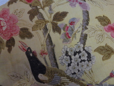
Decorative object - Paradise Bird Design Linen Curtains, GP&J Baker, 1920s
William Turner, a Scottish born free-lance designer, who was contracted to GP&J Baker, painted the image on which the design was based in 1918. Turner had trained as a furniture designer before leaving for London in the 1890s, where he rose to prominence as an Arts & Crafts designer. The bird that gives this design its name is adapted from Robert Havell’s ‘A Collection of Birds of Paradise’, published in 1835, and was a favourite of Victorian chintz designers.“Paradise Bird” has been in continuous production since its creation. The hand-block print, of which these curtains are an early example, was supplemented by a version engraved on copper rollers in 1962, and was updated onto screens in 1982. The curtains have significance to the collection because of their intrinsic value and for the link to one of the historic mansions in the City of Boroondara. The curtains by G.P & J Baker of London use one of the exemplary designs in this manufacturer’s output. The first use of the design was in 1918, following the Great War, and the design is said to reflect the hope for peace which was a feature of the postwar years. The curtains are an early example of the Paradise Bird design, and were block printed. A pair of curtains originally situated in one of the front reception rooms of 'Tourmont' in Balwyn Road, Balwyn (now Fintona Girls’ School). The fabric in the curtains was manufactured by the English firm of GP&J Baker. The textile design is variably named as ‘Paradise Bird’ or more recently, ‘Hydrangea Bird’. Turner’s bird perches in a blossoming branch directly above a woodpecker, which is an attribute of Mars, god of war. Thus the design reads as a symbolic statement where War is reversed and Paradise returns (a hopeful message at the end of WWI). “Paradise Bird” has been in continuous production since its creation. . curtains, fabric design, historic buildings -
 Kew Historical Society Inc
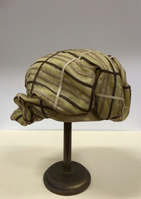
Headwear - Green & Brown Silk 'Cloche' Hat, Anne Harrison of Kew, 1950s
... . The Kew Historical Society’s fashion and design collection ...Marion 'Annie' (Cooper) Harrison, a milliner by trade, designed and made women’s hats, initially in the 1940s in High Street, and later in the 1950s and 60s at 5 Princess Street. The hats were constructed upstairs in her shop in Princes Street while the ground floor was reserved for sales and display. She employed other milliners to assist but always ran the showroom herself. Hectic periods were in the weeks before the big racing carnivals when the many wealthy race-goers of Kew kept her busy. She typically walked to her business as she and her husband, Fred Harrison, lived locally. Annie died in April 2016, at the great age of 107 years. Her hats are held in local and national collections.The Kew Historical Society’s fashion and design collection is comprised of costumes, hats, shoes and personal accessories. Many of these items were purchased or handmade in Victoria; some locally in Kew. The extensive hat collection comprises items dating from the 1860s to the 1970s. While most of the hats in the collection were created by milliners for women, there are a number of early and important men’s hats in the collection. The headwear collection is particularly significant in that it includes the work of notable Australian and international milliners.Pale green silk woman’s hat in a soft unstructured style retailed by Anne Harrison of Kew. The hat is banded with braid in contrasting colours. It has a soft bow at the rear.Label: Anne Harrison of Kew. WM 9906anne harrison, milliners - kew (vic), women's clothing -- hats -
 Kew Historical Society Inc
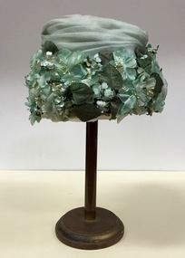
Headwear - Pale Green Silk & Gauze Floral Hat, Harbig, 1950s
... , "but feathers and feathers and feathers".' The Kew Historical Society’s ...The firm of Harbig was a Melbourne millinery company owned by Mr and Mrs Richard Ernest Harbig. In 1949, an article in the West Australian newspaper reported their return from the United States. It records that: 'FEATHERS SYDNEY, Sept. 14: Mr. and Mr. Richard Harbig, Melbourne milliners who reached Sydney by air tonight from America, gave these details of hat trends for next winter. Shapes: Head-hugging cloches to suit short hair, cut away at the back to clear high collars, and built up and out at the front to give height. Materals: Felts, velours, velvets, and a new long-haired fur fabric called flamond. Colours: Muted pastels, few jewel shades, and no vivid colours. Trimmings: Little veiling, "but feathers and feathers and feathers".'The Kew Historical Society’s fashion and design collection is comprised of costumes, hats, shoes and personal accessories. Many of these items were purchased or handmade in Victoria; some locally in Kew. The extensive hat collection comprises items dating from the 1860s to the 1970s. While most of the hats in the collection were created by milliners for women, there are a number of early and important men’s hats in the collection. The headwear collection is particularly significant in that it includes the work of notable Australian and international milliners.Pale green woman’s hat created by Harbig of Melbourne with a large border of flowers and leaves in shades of green. The crown of the hat is swathed with pale green silk gauze.Label: Harbig. Melbourne, New York, Parismilliners -- harbig, women's clothing -- hats, floral hats -
 Kew Historical Society Inc
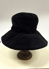
Headwear - Black Straw & Gauze Hat, Janell, 1965-1975
... The Kew Historical Society’s fashion and design collection ...The Kew Historical Society’s fashion and design collection is comprised of costumes, hats, shoes and personal accessories. Many of these items were purchased or handmade in Victoria; some locally in Kew. The extensive hat collection comprises items dating from the 1860s to the 1970s. While most of the hats in the collection were created by milliners for women, there are a number of early and important men’s hats in the collection. The headwear collection is particularly significant in that it includes the work of notable Australian and international milliners.Soft broad brimmed black coloured woman’s hat by Janell constructed of black straw and covered with fine black silk gauze. The shape of the hat is in the 'mushroom' style.Label: Janellmillliners -- australia -- janell, women's clothing -- hats, headwear -
 Kew Historical Society Inc
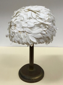
Headwear - White Petal Covered Hat, Beryl Richards, 1960s
... The Kew Historical Society’s fashion and design collection ...The Kew Historical Society’s fashion and design collection is comprised of costumes, hats, shoes and personal accessories. Many of these items were purchased or handmade in Victoria; some locally in Kew. The extensive hat collection comprises items dating from the 1860s to the 1970s. While most of the hats in the collection were created by milliners for women, there are a number of early and important men’s hats in the collection. The headwear collection is particularly significant in that it includes the work of notable Australian and international milliners.Woman’s hat retailed by Beryl Richards of Melbourne which is constructed on a stiffened net and covered with pieces of white fabric cut to simulate the shape of petals.Label: Beryl Richards Hats - Melbourneberyl richards, milliners -- melbourne (vic.), women's clothing -- hats, headwear -
 Kew Historical Society Inc
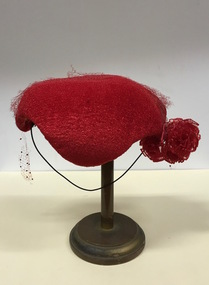
Headwear - Red Fabric & Net Cocktail Hat, 1950s
... The Kew Historical Society’s fashion and design collection ...The Kew Historical Society’s fashion and design collection is comprised of costumes, hats, shoes and personal accessories. Many of these items were purchased or handmade in Victoria; some locally in Kew. The extensive hat collection comprises items dating from the 1860s to the 1970s. Most of the hats in the collection were created by milliners for women. There are however a number of early and important men’s hats in the collection. The headwear collection is particularly significant in that it includes the work of notable Australian and international milliners.Woven red woman’s half hat with the addition of red net and flowers at the side in the same colourNilwomen's clothing -- hats, cocktail hats, headwear -
 Kew Historical Society Inc
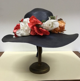
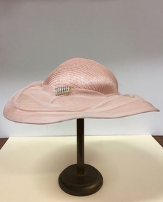
Headwear - Navy Straw & Silk Sun Hat, R & M Dower, 1949
... Kew Historical Society Inc 1 Civic Drive Kew melbourne R&M ...R&M Dower was a major millinery partnership located at 146 High Street, Kew in the 1940s and 1950s. Examples of this millinery firm's hats are in other major public collections, including the National Gallery of Victoria.The Kew Historical Society’s fashion and design collection is comprised of costumes, hats, shoes and personal accessories. Many of these items were purchased or handmade in Victoria; some locally in Kew. The extensive hat collection comprises items dating from the 1860s to the 1970s. While most of the hats in the collection were created by milliners for women, there are a number of early and important men’s hats in the collection. The headwear collection is particularly significant in that it includes the work of notable Australian and international milliners.Wide brimmed navy blue fine straw woman’s hat retailed by R & M Dower of High Street, Kew, with red, white and apricot coloured fabric flowers surrounding the crown of the hat.Label: R & M Dower 146 High St., Kew. Phone WM 8527r & m dower, milliners, hats, australian fashion, women's clothing -
 Kew Historical Society Inc
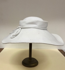
Headwear - White Cartwheel Sun Hat, Clare Ralph, Goullet of Melbourne, c.1970
... crazy sun-hat days. The Kew Historical Society’s fashion ...An article in the Melbourne Age (2 March 1978, p. 25) recorded the retirement of Clare Ralph of Goullet of Melbourne (active 1953-78). "One of Australia's most talented milliners, Clare Ralph, of Goullet, is selling her business because she wants to spend more time in her garden. "I have been in the business for 25 years and last week I turned 60 and so I thought now is the time," Mrs. Ralph said at her Richmond shop yesterday. ... Mrs. Ralph is selling cheaply $10,000 for the label, which also covers sportswear, and tenancy and lease of the premises which have a showroom and workroom. ... Mrs. Ralph is as unpretentious as the relaxed Goullet styling which brought the new concept of millinery to Australia non-hatty hats with none of the "Melbourne Mum" quality so rife at the time. She said she started off making hats rather than dressmaking because she couldn't afford to buy the three yards of material necessary for a dress. "I wanted to get out of the house and so I did millinery night classes at Caulfield Tech." Her first efforts were sun-hats of natural straw which Mrs. Ralph trimmed extravagantly … "gold fishnet and braiding and sparkly jewels all over the crown. "They were ridiculous but a lot of fun," she said. She carted them by train to the city and nervously showed them to a store buyer. After the meeting, she couldn't face taking the samples home again on the train and left them. Before she could collect them, to everyone's amazement particularly Clare Ralph's, they had been sold. "The next thing was people were asking me what I was going to do for winter. I hadn't thought I was in the industry. I just thought I had sold a couple of sun hats and that was marvellous because I needed the money," she said. If the new buyer is interested, Clare Ralph will continue designing hats on a consultancy basis for them, which would be great for all the fans she has collected since those crazy sun-hat days.The Kew Historical Society’s fashion and design collection is comprised of costumes, hats, shoes and personal accessories. Many of these items were purchased or handmade in Victoria; some locally in Kew. The extensive hat collection comprises items dating from the 1860s to the 1970s. Most of the hats in the collection were created by milliners for women. There are however a number of early and important men’s hats in the collection. The headwear collection is particularly significant in that it includes the work of notable Australian and international milliners.Wide brimmed woman’s hat designed by Clare Ralph of Goullet of Melbourne, constructed of white stiffened fabric with a white fabric cord surrounding the crown of the hat.Label: Designed by Goullet of Melbournegoullet of melbourne, clare ralph -- milliner, women's clothing -- hats, headwear -
 Kew Historical Society Inc
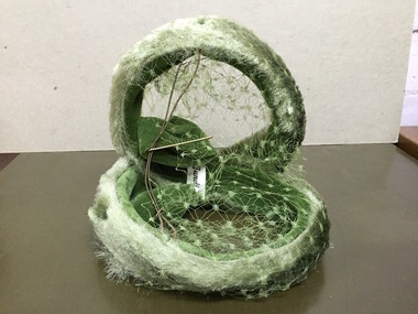
Headwear - Green Velvet 'Fascinator', Janell, 1950s
... The Kew Historical Society’s fashion and design collection ...The Kew Historical Society’s fashion and design collection is comprised of costumes, hats, shoes and personal accessories. Many of these items were purchased or handmade in Victoria; some locally in Kew. The extensive hat collection comprises items dating from the 1860s to the 1970s. While most of the hats in the collection were created by milliners for women, there are a number of early and important men’s hats in the collection. The headwear collection is particularly significant in that it includes the work of notable Australian and international milliners.Pale green woman’s fascinator retailed by Janelle which is constructed of two joined circles and covered with net of the same colourLabel: Janellemilliners -- australia -- janell, milliners -- janell, women's clothing -- hats, fascinators, headwear -
 Kew Historical Society Inc
Headwear - Brown Felt & Black Ribbon 'Cloche' Hat, Anne Harrison of Kew, 1950s
... . The Kew Historical Society’s fashion and design collection ...Marion “Annie” (Cooper) Harrison, a milliner by trade, designed and made women’s hats, initially in the 1940s in High Street, and later in the 1950s and 60s at 5 Princess Street. The hats were constructed upstairs in her shop in Princes Street while the ground floor was reserved for sales and display. She employed other milliners to assist but always ran the showroom herself. Hectic periods were in the weeks before the big racing carnivals when the many wealthy race-goers of Kew kept her busy. She typically walked to her business as she and her husband, Fred Harrison, lived locally. Annie died in April 2016, at the great age of 107 years. Her hats are held in local and national collections.The Kew Historical Society’s fashion and design collection is comprised of costumes, hats, shoes and personal accessories. Many of these items were purchased or handmade in Victoria; some locally in Kew. The extensive hat collection comprises items dating from the 1860s to the 1970s. While most of the hats in the collection were created by milliners for women, there are a number of early and important men’s hats in the collection. The headwear collection is particularly significant in that it includes the work of notable Australian and international milliners.Apricot coloured felt woman’s hat retailed by Anne Harrison of Kew. The design includes a contrasting band of black ribbon at the base of the crown. The ribbon is shaped into a flat bow at the rear of the hat.Label: Anne Harrison of Kew. WM 9906anne harrison, milliners - kew (vic), women's clothing, costume accessories -
 Kew Historical Society Inc
Headwear - Multicoloured Silk Floral Hat, R & M Dower, 1960s
... Kew Historical Society Inc 1 Civic Drive Kew melbourne R&M ...R&M Dower was a major millinery partnership located at 146 High Street, Kew in the 1940s and 1950s. Examples of this millinery firm's hats are in other major public collections, including the National Gallery of Victoria.The Kew Historical Society’s fashion and design collection is comprised of costumes, hats, shoes and personal accessories. Many of these items were purchased or handmade in Victoria; some locally in Kew. The extensive hat collection comprises items dating from the 1860s to the 1970s. While most of the hats in the collection were created by milliners for women, there are a number of early and important men’s hats in the collection. The headwear collection is particularly significant in that it includes the work of notable Australian and international milliners.Small brimless woman’s hat retailed by R & M Dower of High Street, Kew. The structure of the hat is made of stiffened net, covered with multicoloured flowers, leaves and a purple ribbon.Label: R & M Dower, 146 High St., Kew. Phone WM 8527.r & m dower, milliners -- kew (vic.), women's clothing -- hats, headwear -
 Kew Historical Society Inc
Headwear - Pink Felt & Ribbon Fedora, La Rene, 1960s
... Kew Historical Society Inc 1 Civic Drive Kew melbourne ...In the descriptions of two hats by La Rene in the Museum Victoria collection it is suggested that their origin may be French. La Rene was also a Sydney design house and it is believed that the fedora in the Kew collection is an Australian product. This hat and the MV examples have similar attributes.The Kew Historical Society’s fashion and design collection is comprised of costumes, hats, shoes and personal accessories. Many of these items were purchased or handmade in Victoria; some locally in Kew. The extensive hat collection comprises items dating from the 1860s to the 1970s. While most of the hats in the collection were created by milliners for women, there are a number of early and important men’s hats in the collection. The headwear collection is particularly significant in that it includes the work of notable Australian and international milliners.Deep pink coloured felt woman’s fedora by La Rene with a broad navy ribbon at the base of the crown. The rim is fastened to the crown at one side of the hat.Label: Fashioned by La Rene. 37-6622; 36-1690women's clothing -- hats, headwear, milliners - la rene -
 Kew Historical Society Inc
Headwear - White Feather 'Turban, 1960s
... The Kew Historical Society’s fashion and design collection ...The Kew Historical Society’s fashion and design collection is comprised of costumes, hats, shoes and personal accessories. Many of these items were purchased or handmade in Victoria; some locally in Kew. The extensive hat collection comprises items dating from the 1860s to the 1970s. While most of the hats in the collection were created by milliners for women, there are a number of early and important men’s hats in the collection. The headwear collection is particularly significant in that it includes the work of notable Australian and international milliners.A conical, stiffened net, woman's hat covered in white silk and feathers. Nilwomen's clothing -- hats, headwear, hats -- turbans -
 Kew Historical Society Inc
Headwear - High Crowned, Wide Brimmed Hat, Caterina Lucci, 1980s
... The Kew Historical Society’s fashion and design collection ...The Kew Historical Society’s fashion and design collection is comprised of costumes, hats, shoes and personal accessories. Many of these items were purchased or handmade in Victoria; some locally in Kew. The extensive hat collection comprises items dating from the 1860s to the 1970s. While most of the hats in the collection were created by milliners for women, there are a number of early and important men’s hats in the collection. The headwear collection is particularly significant in that it includes the work of notable Australian and international milliners.Broad-rimmed soft, black polyester velvet woman’s hat designed by Caterina Lucci and imported to Australia by Crochetta.Label: Caterina Lucci [A Crochetta import]. Made in Chinawomen's clothing -- hats, headwear, caterina lucci -
 Kew Historical Society Inc
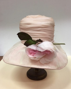
Headwear - Pink Silk & Chiffon Hat, 1970s
... Kew Historical Society Inc 1 Civic Drive Kew melbourne ...The hat was owned, worn and donated by by Jill O'Brien, member of the Kew Historical Society and a former mayor of Kew. The rose is a later addition.The Kew Historical Society’s fashion and design collection is comprised of costumes, hats, shoes and personal accessories. Many of these items were purchased or handmade in Victoria; some locally in Kew. The extensive hat collection comprises items dating from the 1860s to the 1970s. While most of the hats in the collection were created by milliners for women, there are a number of early and important men’s hats in the collection. The headwear collection is particularly significant in that it includes the work of notable Australian and international milliners.Soft pink coloured woman’s hat; the high crown swathed in fine pink silk, while the brim is covered with white chiffon. Two large floppy silk roses are used to decorate the hat.Nilmilliners, hats, women's clothing, australian fashion, jill o'brien -
 Kew Historical Society Inc
Headwear - Pink Straw Cartwheel Hat, 1950s
... The Kew Historical Society’s fashion and design collection ...The Kew Historical Society’s fashion and design collection is comprised of costumes, hats, shoes and personal accessories. Many of these items were purchased or handmade in Victoria; some locally in Kew. The extensive hat collection comprises items dating from the 1860s to the 1970s. While most of the hats in the collection were created by milliners for women, there are a number of early and important men’s hats in the collection. The headwear collection is particularly significant in that it includes the work of notable Australian and international milliners.Pale pink coloured straw woman’s hat featuring a low crown and a wide brim. The latter is covered with silk chiffon of the same colour. A metallic adornment comprised of concentric rings is attached to the base of the crown. Nilstraw hats, sun hats, cartwheel shape hats, women's clothing -- hats, headwear -
 Kew Historical Society Inc
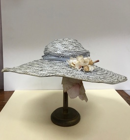
Headwear - Grey Raffia Sun Hat, 1930s
... The Kew Historical Society’s fashion and design collection ...The Kew Historical Society’s fashion and design collection is comprised of costumes, hats, shoes and personal accessories. Many of these items were purchased or handmade in Victoria; some locally in Kew. The extensive hat collection comprises items dating from the 1860s to the 1970s. While most of the hats in the collection were created by milliners for women, there are a number of early and important men’s hats in the collection. The headwear collection is particularly significant in that it includes the work of notable Australian and international milliners.A grey woven raffia woman’s hat featuring a wide brim. A narrow grey ribbon is used at the base of the crown. A posy of ivory coloured flowers is attached to the rim.Nilsun hats, women's clothing -- hats, headwear, straw hats -
 Kew Historical Society Inc
Headwear - Wide brimmed straw hat, 1960s
... The Kew Historical Society’s fashion and design collection ...The Kew Historical Society’s fashion and design collection is comprised of costumes, hats, shoes and personal accessories. Many of these items were purchased or handmade in Victoria; some locally in Kew. The extensive hat collection comprises items dating from the 1860s to the 1970s. Most of the hats in the collection were created by milliners for women. There are however a number of early and important men’s hats in the collection. The headwear collection is particularly significant in that it includes the work of notable Australian and international milliners.A dusky pink straw woman’s hat with a wide brim. The hat features a fitted pink ribbon at the base of the crown and a white rose (sic) attached to the flat bow of the ribbon.Nilheadwear, women's hats, clothing -
 Kew Historical Society Inc
Headwear - Wide-Brimmed Pink Straw Sun Hat, 1970s
... The Kew Historical Society’s fashion and design collection ...The Kew Historical Society’s fashion and design collection is comprised of costumes, hats, shoes and personal accessories. Many of these items were purchased or handmade in Victoria; some locally in Kew. The extensive hat collection comprises items dating from the 1860s to the 1970s. While most of the hats in the collection were created by milliners for women, there are a number of early and important men’s hats in the collection. The headwear collection is particularly significant in that it includes the work of notable Australian and international milliners.Very finely woven pink straw hat with a very large rim. The low-domed crown is surrounded by a band of black velvet to which are attached deep purple grapes. Black net is attached to the ribbon. Nilwomen's clothing -- hats, sun hats, straw hats -
 Kew Historical Society Inc
Headwear - Straw Sun Hat, 1970s
... The Kew Historical Society’s fashion and design collection ...The Kew Historical Society’s fashion and design collection is comprised of costumes, hats, shoes and personal accessories. Many of these items were purchased or handmade in Victoria; some locally in Kew. The extensive hat collection comprises items dating from the 1860s to the 1970s. While most of the hats in the collection were created by milliners for women, there are a number of early and important men’s hats in the collection. The headwear collection is particularly significant in that it includes the work of notable Australian and international milliners.Wide brimmed straw woman’s hat banded at the crown and on the rim with black ribbon. Highlighting the lower part of the crown are regularly spaced black plastic buttons. Attached to the bow is a posy of crimson poppies.Nilwomen's clothing -- hats, sun hats, straw hats -
 Kew Historical Society Inc
Headwear - Brown Straw Cartwheel Hat, Trude Jonas, c. 1954
... Kew Historical Society Inc 1 Civic Drive Kew melbourne ...Trude Jonas was a Melbourne milliner with her business operating from 159 Mavern Road, Malvern.The Kew Historical Society’s fashion and design collection is comprised of costumes, hats, shoes and personal accessories. Many of these items were purchased or handmade in Victoria; some locally in Kew. The extensive hat collection comprises items dating from the 1860s to the 1970s. While most of the hats in the collection were created by milliners for women, there are a number of early and important men’s hats in the collection. The headwear collection is particularly significant in that it includes the work of notable Australian and international milliners.Elegant broad rimmed purple straw woman’s hat retailed by Trude Jonas with a purple ribbon of the same colour at the base of the crown.Label: Trude Jonas. Model Hats, 159 Glenferrie Rd., Malvern.milliners -- malvern (vic.), milliners -- melbourne -- trude jonas, trude jonas -- model hats