Showing 11326 items matching "land-clearing"
-
 Ballarat Heritage Services
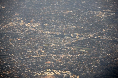
Digital photographs, L.J. Gervasoni, Kew from the Air, c2014
Colour aerial photograph of the Melbourne Suburb of Kew taken from an aeroplane coming into land at Tullamarine Airport, Melbourne. melbourne, kew, hawthorn, camberwell, landscape, aerial -
 Ballarat Heritage Services
Photograph - Colour, Clare Gervasoni, Seventh Street, Hepburn Springs, 2015, 25/08/2015
Colour photograph showing a block of land about to be built on at the Spring Creek side of Seventh Street in Hepburn Springs.hepburn springs -
 Whitehorse Historical Society Inc.
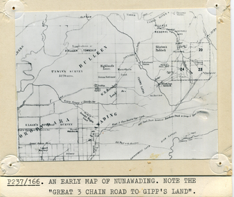
Photograph - B/W Photograph, Map of Nunawading
Black and white photo of early sub-division of Nunawading.|NOTE:- Great 3 Chain Road to Gipp's Land.nunawading, map -
 Bendigo Historical Society Inc.
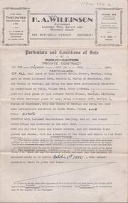
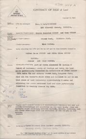
Document - H. A. & S. R. WILKINSON COLLECTION: CONTRACT OF SALE
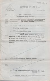
Conditions of sale by private contract dated 19th July, 1950 between R. C. Orde (vendor) and H. J. & M. E. Stephenson (purchaser). Property: all that piece of land situate in Havlin Street, Bendigo being part of Crown allotment 326A section H, Parish of Sandhurst City of Bendigo, land described in certificate of title volume 5965 folio 1192804. Also all that piece of land situate in Havlin street adjoining the above mentioned land being allotment 326C section H land described in crown Grant volume 6018 folio 1293456, together with 5 room weatherboard dwelling and all sundry outbuildings, all fly wire doors, window screens, electric light globes and shades, with exception of the shade and chains in the front bedroom. Price: 2,585 pounds.organization, business, h.a. & s.r wilkinson real estate -
 Bendigo Historical Society Inc.
Document - H. A. & S. R. WILKINSON COLLECTION: CONTRACT OF SALE
Contract of sale of land dated 29th April, 1957 between Miss M. J Schier & Mrs. M. Turner (vendor) and Mr. W. J. & Mrs. E. O. Sutton (purchaser). Property: land being part of Crown allotment 23 section G Parish of Mandurang county of Bendigo, land described in certificate of title volume 7374 folio 714 and situated Crusoe Road, Kangaroo Flat. Also all vendor's right title and interest in to that piece of land containing approx. 6 acres and adjoining the above mentioned land described in grazing licence no. 0349. Together with 6 roomed brick and weatherboard dwelling, all sundry outbuildings, electric light fittings, kitchen cabinet, blinds, curtains and floor coverings with exception of the carpet in the lounge. Price: 3,500 pounds. Attached Statement pursuant to section 34 of the estate agents' act 1956.organization, business, h.a. & s.r wilkinson real estate -
 Halls Gap & Grampians Historical Society
Photograph
A temporary saw-mill in the central Grampians.Photo shows a clearing containing a saw mill. There is a saw with traction engine to the right ands a bullock wagon containing a large log to the left. There is a man to the right working with the engine, four men among the wood in the centre and two men near the wagon on the left. A large wood stump is prominent in the foreground. timber industries, logging, sawmilling -
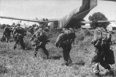 National Vietnam Veterans Museum (NVVM)
Photograph - 5RAR, Gibbons, Denis
Denis Gibbons (1937 – 2011) Trained with the Australian Army, before travelling to Vietnam in January 1966, Denis stayed with the 1st Australian Task Force in Nui Dat working as a photographer. For almost five years Gibbons toured with nine Australian infantry battalions, posting compelling war images from within many combat zones before being flown out in late November 1970 after sustaining injuries. The images held within the National Vietnam Veterans Museum make up the Gibbons Collection. A black and white photograph of Diggers of 5 RAR boarding a Caribou aircraft from the RAAF's 35 Squadron, to be transported back to the 1st Australian Task Force Base, Nui Dat, Phuoc Tuy Province. 5 RAR had just completed the clearing of NVA/VietCong from Xuyen Moc.photograph, 5 rar, caribou, raaf, 35 squadron, 1st atf base, nui dat, phuoc tuy province, nva/vc, xuyen moc, gibbons collection catalogue, denis gibbons, photographer, vietnam war, diggers -
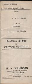 Bendigo Historical Society Inc.
Document - H.A & S.R. WILKINSON COLLECTION: CONTRACT OF SALE
Conditions of sale by private sale dated 10th April, 1940 between W.V.O. Earl (seller) and C.M.F. Skilbeck (buyer) for land situate No.148 Booth Street, Bendigo, being the land described in right to occupy residence area No.4501. Also all the vendor's right, title and interest in that piece of land adjoining the above mentioned land described in permissive occupancy title no. W.52845, together with 5-roomed weatherboard dwelling and all sundry. Also bath, copper and troughs. Price 175 pounds. Attached 5 receipt issued by Department of Lands and Survey plus 2 receipt from City of Bendigo for rates. Vendor's copy.organization, business, h.a. & s.r wilkinson real estate -
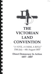 Bendigo Historical Society Inc.
Book - THE VICTORIAN LAND CONVENTION, 2007
The Victorian Land Convention, ''A Vote, A Farm, A Rifle'' 15th July - 6th August 1857 Direct Democracy In Action 1857 - 2007. This booklet was published to mark the 150th anniversary of the Victorian Land Convention. The Land Convention, held in Melbourne in 1857 opposite Victoria's newly built Parliament House, was a far more revolutionary act than the 1854 Ballarat rebellion. The effects of the Land Convention influenced parliamentary debate for nearly two decades. It laid the groundwork for the rich radical traditions that Melbourne 150 years later, is still famous for. 28 pages in spring bound folder. written by Dr. Joseph Toscano, Anarchist Media Institute, MelbourneDr Joseph Toscanohistory, australian, victoria. -
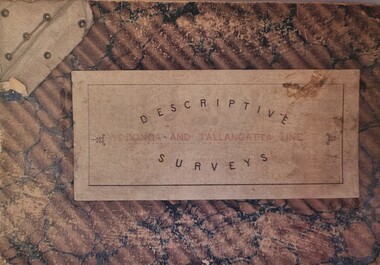 Wodonga & District Historical Society Inc
Booklet - Descriptive Surveys - Wodonga - Tallangatta Line
The first section of the Wodonga to Tallangatta line opened in 1889 and was further extended in 1891. It was a vital community link until the passenger service closed in September 1961. The last regular goods train on the line ran on 21st April 1978. These maps give detail of the surveying and building of the line.A collection of replicas of survey maps acquired to build the Wodonga to Tallangatta Railway line. Each survey includes a diagram of a portion of the line showing survey measurements and details of the land which that portion of the line will run through. It also includes the name of the landowner from whom the necessary land was acquired.The first section of the Wodonga to Tallangatta line opened in 1889 and was further extended in 1891. It was a vital community link until the passenger service closed in September 1961. The last regular goods train on the line ran on 21st April 1978. These maps give detail of the surveying and building of the line.victorian railways, wodonga to tallangatta rail service -
 Bendigo Historical Society Inc.
Document - CROWN LAND TRACINGS, BENDIGO, 1890 - 1910
Document: Crown land tracings, dark buff coloured foolscap paper tied with white tape. On front ' Crown Lands tracings 1890 - 1910'. Contains applications for crown lands, City of Bendigo, 1890 - 1910 including list of allotments, names of persons, locality and tracings of land referred to.crown land tracings, bendigo, sandhurst, land sales, crown land -
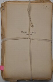
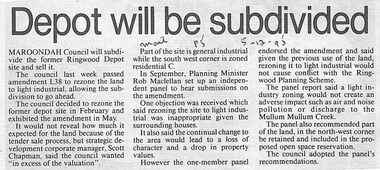 Ringwood and District Historical Society
Newspaper, Scrapbook Clipping, Library Collection, Ringwood, Victoria, `
``Newspaper clipping from "The Mail"5-12-95", P 5. Depopt will be subdivided. Maroondah Council will subdivide the former Ringwood Depot site and sell it. The council last week passed amendment 1.38 to rezone the land to light industrial, allowing the subdivision to go ahead. It would not reveal how much it expected for the land because of the tender sale process.` -
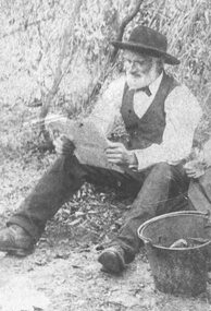 Ringwood and District Historical Society
Photograph, Early Heathmont pioneer Mr. Pett in later life about 1900
Black and white photograph (2 copies)Typed below photograph: "Mr. Pett in later life about 1900. An early pioneer of Heathmont. Owned 80 acres south of the intersection of Bedford and Canterbury Roads". Written on rear of backing sheet, "Pett sold his land to Tommy Bent the land speculator". -
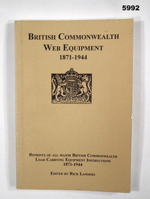 Bendigo Military Museum
Book - BOOK, REFERENCE, Rick LANDERS, " BRITISH COMMONWEALTH WEB EQUIPMENT 1871-1944", 2005
Peter Ball collection, refer Cat No 4704.Soft cover book. Cover - cardboard, black print on front and spine, beige background, small illustration. British Coat of Arms. 192 pages, cut, plain, white paper. Illustrated black and white illustration, diagrams and photographs. Handwritten - signature of author and owner's name.Handwritten signatures - front end paper - owner "Peter C Ball". Title page - author - "Rick Landers".books, reference guide, history, military accoutrements, british -
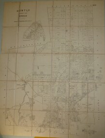 Bendigo Historical Society Inc.
Map - JACK FLYNN COLLECTION: HUNTLY, 8/09/1921
Map: Parish of Huntly, County of Bendigo. Parish plan.By Authority, Govt., Printer. A. J. Mullett. Photo Lithographed at the Department of Land and Survey Melbourne By W. J. Butsonmap, bendigo, parish plan, huntly -
Clunes Museum
Map, Township of Clunes - Parish of Clunes - County of Talbot
Map of Clunes Township in 19511 X PHOTOCOPY OF MAP, (COMPRISING A NUMBER OF A4 SHEETS TAPED TOGETHER) SHOWING LOT NUMBERS AND NAMES OF LANDHOLDER. REFERENCE GAZ 1951.1480. SCALE 30 CHAINS = 1 INCH 1 X PHOTOCOPY OF MAP, (COMPRISING A NUMBER OF A4 SHEETS TAPED TOGETHER) SHOWING LOT NUMBERS AND NAMES OF LANDHOLDER. REFERENCE: G76359 GENERAL FILE TOWNSHIP RESIDENTIAL ALLOTMENTS SCALE 30 CHAINS = 1 INCHNOTATED IN PURPLE CRAYON ON SECOND MAP: AS AT LATE 1984 COPY OF MAP FROM LAND TITLES OFFICE BALLARATtownship of clunes map, 1951 -
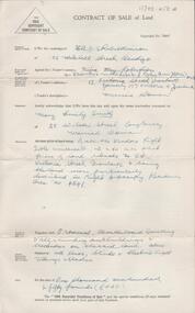
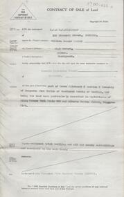
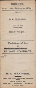 Bendigo Historical Society Inc.
Document - H.A. & S.R. WILKINSON COLLECTION: CONTRACT OF SALE
Conditions of sale by private contract dated 9th February, 1934 between H.A. Wilkinson (seller) and Mrs. E.F. Rigby (buyer) for land situate Creek Street, Bendigo described in certificates of title volume 2776 folio 555075 and volume 5725 folio 1144852. Also all the vendor's right title and interest in and to that portion of land facing Clarke Street as fenced and adjoining above mentioned land, together with 5-roomed weatherboard dwelling and all sundry. Price 350 pounds.organization, business, h.a. & s.r wilkinson real estate -
 Bendigo Historical Society Inc.
Document - H. A. & S. R. WILKINSON COLLECTION: CONTRACT OF SALE
Contract of sale of land dated 13th September, 1956 between Mrs. N. M. Robertson executor estate L. A. Morris deceased (vendor) and Mrs. M. E. Smith (purchaser). Property: land situate No. 34 Victoria Street, Ironbark, being land described in right to occupy residence area no. 4541, together with 5 roomed weatherboard dwelling, all sundry outbuildings also all linos, blinds and electric light fittings and shades. Price: 1,150 pounds.organization, business, h.a. & s.r wilkinson real estate -
 Bendigo Historical Society Inc.
Document - H. A. & S. R. WILKINSON COLLECTION: CONTRACT OF SALE
Contract of sale of land dated 11th January, 1955 between Mr. W. H. Connor (vendor) and Mr. R. A. Tuohey (purchaser). Property: piece of land being part of Crown allotment 2 section 6 township of Kangaroo Flat Parish of Sandhurst City of Bendigo, land described in certificate of title volume 7481 folio 039 and situate in Gordon Street, Kangaroo Flat, together with cement brick dwelling and all sundry outbuildings. Price: 2,500 pounds.organization, business, h.a. & s.r wilkinson real estate -
 Bendigo Historical Society Inc.
Document - H. A. & S. R. WILKINSON COLLECTION: CONTRACT OF SALE
Contract of sale of land dated 29th January, 1954 between Sandhurst & Northern District Trustees Executors and Agency, Estate of M. J. Wearne - Deceased (vendor) and Mrs. I. P. Trewella (purchaser). Property: land being part of Crown allotment 11 section 25B Parish of Sandhurst City of Bendigo, land described in Conveyance registered number880 book 543 and situate 44 Rowan Street, Bendigo, together with all buildings thereon. Price: 1,425 pounds .organization, business, h.a. & s.r wilkinson real estate -
 Melbourne Tram Museum
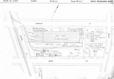
Drawing, Melbourne & Metropolitan Tramways Board (MMTB), "South Melbourne Depot", c1937
Set of five photocopied plans or drawings on A3 sheet of "South Melbourne Depot" - c 1937 .1 - P8345 - Plan of land showing MMTB land and surrounding properties. .2 - P8346 - Plan of land showing detail of offices .3 - P8347 - Plan showing detail of tram shed and adjacent buildings .4 - P8348 - Plan showing detail of buildings along the side of the block. .5 - P8349 - Plan showing details of the per way yard and associated facilities.trams, tramways, drawings, depots, property, south melbourne depot -
 Vision Australia
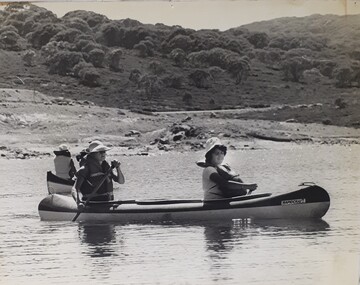
Photograph - Image, Two woman paddling in a canoe
In this image two woman sit in a canoe and paddle across a waterway. There are bushes and trees in the background, with a wide clearing separating the water way from the bush. Both woman wear life jackets and hats.1 black and white photograph of woman in a canoerecreation, canoeing -
 Kiewa Valley Historical Society
Photograph of Kiewa Valley Panorama, Farming lands within the Kiewa Valley in1950s, Circa 1950
This photograph shows how (early to mid1900s), before the establishment of the Mount Beauty "gated" village, the Kiewa Valley was farmed and the scarce population was spread out over acres of productive land. This photograph catches a time before (what appeared to the local farmers as the invasion by a mass of construction workers) when this remote valley was part of a "lay back" rural landscape,occasionally visited by friends and some wayward tourists. The mountain ranges provided an adequate barrier against the way-would traveller. The immigration numbers coming into Australia was still quite small ( due to the "white" Australia policy) which was in force before World War II. After World War II a mass of displaced European refugees and migrants boosted the Australian population and provided for a greater degree of diverse professions and rural related work force.This photograph depicts the borderline in time between an exclusively rural based population and respective activities(early 1900s)to the present (2000 on wards) integrated village, tourist and retiree/holiday area. The time when land was exclusively used in agriculture is over and the impact of cheaper rural produce from Asian markets will see a shift of land useage and population activities. The Kiewa Valley is loosing its hiding place and is becoming more and more a source of untapped residential land. Black and white photograph of farming/grazing land useage, before the establishment of the Mount Beauty Village. Small pockets of residentual houses can be viewed. Road access (unsealed dirt) was typical of that provided in rural regions in the 1950s. The photo is on 200gms paper and not on photographic paper.kiewa valley in the early1900s, grazing in the kiewa valley, sec victoria -
 Kew Historical Society Inc
Plan - Subdivision Plan, Cotham Vale Estate, 1919
Pru Sanderson, in her groundbreaking ‘City of Kew Urban Conservation Study : Volume 2 - Development History’ (1988), summarised the periods of urban development and subdivisions of land in Kew. The periods that she identified included 1845-1880, 1880-1893, 1893-1921, 1921-1933, 1933-1943, and Post-War Development. These periods were selected as they represented periods of rapid growth or decline in urban development. An obvious starting point for Sanderson’s groupings involved population growth and the associated economic cycles. These cycles also highlighted urban expansion onto land that was predominantly rural, although in other cases it represented the decline and breakup of large estates. A number of the plans in the Kew Historical Society’s collection can also be found in other collections, such as those of the State Library of Victoria and the Boroondara Library Service. A number are however unique to the collection.The Kew Historical Society collection includes almost 100 subdivision plans pertaining to suburbs of the City of Melbourne. Most of these are of Kew, Kew East or Studley Park, although a smaller number are plans of Camberwell, Deepdene, Balwyn and Hawthorn. It is believed that the majority of the plans were gifted to the Society by persons connected with the real estate firm - J. R. Mathers and McMillan, 136 Cotham Road, Kew. The Plans in the collection are rarely in pristine form, being working plans on which the agent would write notes and record lots sold and the prices of these. The subdivision plans are historically significant examples of the growth of urban Melbourne from the beginning of the 20th Century up until the 1980s. A number of the plans are double-sided and often include a photograph on the reverse. A number of the latter are by noted photographers such as J.E. Barnes.The Cotham Vale Estate was a subdivision of land between Alfred, Thomas, Rowland and John Streets. It was promoted in the same time as the nearby Normanby Heights Estate. Cotham Vale included 28 allotments. Contemporary newspaper advertisements noted that the Estate ‘is most conveniently situated in a well elevated position, only 2 minutes from Cotham rd. Electric Cars, penny section to Kew station’.subdivision plans - kew, cotham vale estate, rowland street -- kew (vic.), thomas street -- kew (vic.), john street -- kew (vic.) -
 Warrnambool and District Historical Society Inc.
Title Search Document, 1930s to 1960s
These documents concern the property in South Warrnambool, Jetty Allotment 7, Section 4. They include a search made of the title of this property in 1937 and information on later purchasers of the property. The first owner of this property was James Cust who purchased it in April 1853. James Cust (1815-1860) came from Ireland to Australia in 1841. From 1847 on he farmed first at Woodford and then moved into Warrnambool and began land speculating.. In 1856 his property was valued at £20,000 but by 1858 he was declared insolvent following the insolvency of his financial backer, William Bateman and his properties were sold. He died in 1860 following an accident at a Ballarat gold mine. Other notable Warrnambool identities who owned this property on Pertobe Road included Thomas King, Christopher Beattie, Thomas Goodall, William McMahon and Alan Lane.These documents are of interest as they detail the history of a property in Warrnambool up to the 1960s. They are also an example of the type of property once owned by James Cust, an important early land speculator in Warrnambool. These are nine loose sheets of paper concerning a legal search made of a block of land in Warrnambool and later documents on the same property The papers contain handwriting in blue and black ink and pencil and one red stamp. One of the pages is an invoice for the charge made for the search.‘Searched 25/5/37 W.D. Richardson Titles Searcher 418 Little Collins Street Melbourne C1’james cust,, history of warrnambool -
![Map, Plan of Subdivision [Allotments along Lerderderg, George and McFarland Streets]](/media/collectors/5e461d8021ea67224c82f2a1/items/675d7243165f146b8adfc656/item-media/675d72d7165f146b8adfc859/item-fit-380x285.jpg) Bacchus Marsh & District Historical Society
Bacchus Marsh & District Historical SocietyMap, Plan of Subdivision [Allotments along Lerderderg, George and McFarland Streets]
This map shows allotments of land on the northern side of Lerderderg Street from Gisborne Road through to the approximate site of the present day Bacchus Marsh Primary School. There are also allotments shown on the southern side of McFarland Street between George Street and Gisborne Road. Larger allotments of land are shown extending northwards towards Masons Lane. Inscribed at the top of the map are the words, 'Plan of Subdivision of Cr Pors (Crown Portions) 12 & 13 & Allotments 1,2,3,4, Block 3, Parish of Korkuperrimul, County of Bourke'. The date of the map has not been established but the absence of the Bacchus Marsh Primary School on the map suggests it may have been produced prior to 1865 when the primary school was built in Lerderderg Street.Single page map showing house block size land allotments in the Lerderderg, George Street and McFarland Street area of Bacchus Marsh with larger allotments north of this area towards Masons Lane also shown. Scale 150 feet to 1 inch. Part of a set of maps which are pasted into a bound volume containing 76 maps or plans in total. High resolution digital image stored on BMDHS computer network. bacchus marsh victoria maps, lerderderg street land allotments, mcfarland street land allotments -
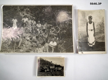 Bendigo Military Museum
Photograph - PHOTOGRAPHS, WW2, 1941 onwards
Richard Alexander Hanson initially enlisted in the CMF No V85605, transfers to the AIF No VX111070 on 18.6.1940 age 29 years. posted to New Guinea as CO of a heavy Artillery installation team. Later posted as CO of a Japanese POW Camp New Guinea. Discharged on 7.6.1946 with the rank of Capt in Port Phillip Coastal Battery..1) Photo B & W showing a group of 20 soldiers including one native al in different stances in a jungle clearing. .2) Photo B & W of a truck/trailer with some sort of lifting device over. .3) Photo B & W of a New Guinea Native girl in a white dress..1) Paper stuck on rear basically says, "Capt R.A. Hanson is in front and to the right of the Digger in black shorts and hat back row". .3) On rear, "KOWI (?) May 1941 Port Moresby, Alec".photographs, artillery, new guinea -
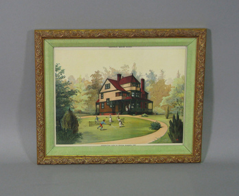 Tennis Australia
Page from catalogue, Oct 1886
Page from Shopell's Modern Houses catalogue of October 1886, entitled 'PERSPECTIVE VIEW OF DESIGN NUMBER 398', featuring a lithograph depicting a large house in a clearing and people playing tennis on the lawn in front of it. Photocopy of magazine cover is adhered to backing of frame. Materials: Paper, Ink, Wood, Cardboard, Glasstennis -
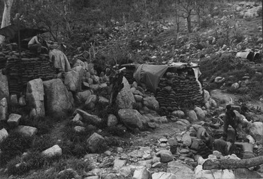 National Vietnam Veterans Museum (NVVM)
Photograph, Gibbons, Denis, Horseshoe Feature 1
Denis Gibbons (1937 – 2011) Trained with the Australian Army, before travelling to Vietnam in January 1966, Denis stayed with the 1st Australian Task Force in Nui Dat working as a photographer. For almost five years Gibbons toured with nine Australian infantry battalions, posting compelling war images from within many combat zones before being flown out in late November 1970 after sustaining injuries. The images held within the National Vietnam Veterans Museum make up the Gibbons Collection. A black and white photograph of fortifications and a lookout post at the 'Horseshoe Feature' . The Diggers in the lower right-hand corner of the photograph are clearing an area between a large rock crevice to construct their fortified bunker. The 'Horseshoe Feature' was regularly mortared and rocketed by the NVA/VietCong. The feature served as an interdiction site.(Circa early 1967)photograph, digger, horseshoe feature, nva/vc, gibbons collection catalogue, denis gibbons, photographer, vietnam war, diggers -
 Bayside Gallery - Bayside City Council Art & Heritage Collection
Photograph, Department of Crown Lands and Survey, Victoria, Melbourne Project: Brighton, 1976
The Department of Crown Lands and Survey (1857-1983) was responsible for the administration of survey and mapping and the sale, occupation and management of crown land throughout its existence. This aerial photograph shows parts of Brighton and was taken on 1 December 1976brighton, department of crown lands and survey, aerial photograph, bayside, port phillip bay, map, cartographic material, melbourne project 1976, brighton yacht club, middle brighton baths, north road, st kilda street, new street