Showing 110057 items matching "roads"
-
 Whitehorse Historical Society Inc.
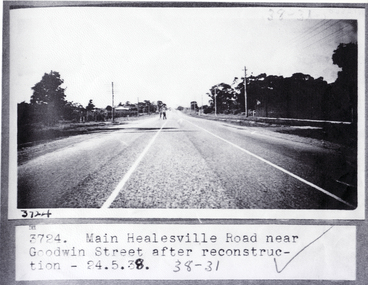
Photograph, Main Healesville Road 1938, 24/05/1938 12:00:00 AM
Black and white photograph of main Healesville Road (Whitehorse Road) near Goodwin Street, Blackburn after road construction on 24 May 1938. Other Number 3724healesville road, blackburn, goodwin street, blackburn., whitehorse road -
 Whitehorse Historical Society Inc.
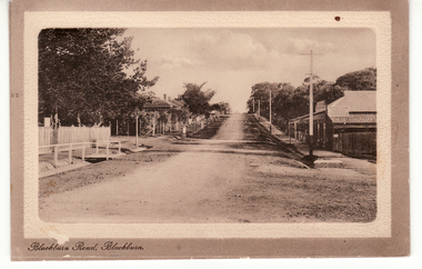
Postcard, Blackburn Road Blackburn circa 1914, 1914
Black and white postcard titled 'Blackburn Road, Blackburn'. Scene shows Blackburn Road looking South from railway gates. Shop on one corner. Unmade road.hooke, albert arthur, blackburn road, blackburn, janet emily -
 City of Kingston
Pamphlet - Colour, Moorabbin News Print, Auction = Sale Heather Grove Estate, c. 1914
Sales plan for land in the suburb of Cheltenham, bounded by Tulip Grove and Heather Grove.The developing urban area of Highett within the City of Kingston. This land sale pamphlet illustrates the subdivision of land within the municipality and the changing demographic of the district as new houses are constructed close to infrastructure.Colour pamphlet advertising auction of Heather Grove Estate, Cheltenham. Incorporates a map of the estate bordered by Wickham Road, Railway Parade, Highett Road and Point Nepean Road.Handwritten in grey pencil on subdivision 1: Sold / 20/- Handwritten in grey pencil on subdivision 2: 25/- Handwritten in grey pencil on subdivision 3: 30/- Handwritten in grey pencil on subdivision 4: 110 / 30/- Handwritten in grey pencil on subdivisions 1, 11, 10, 9 and 8: Sold Handwritten in grey pencil beneath 'Heather Grove': 20/- 20/- 20/- 20/- Handwritten in black ink on subdivison 12 and 7: £85 Handwritten in back ink on subdivision 5: £60 Handwritten in back ink on subdivision 6: £65 Handwritten in grey pencil above subdivision map: 1-8-9-10-11 Handwritten in grey pencil above subdivision map: [enclosed in a circle] 12- / £75 Handwritten in grey pencil above subdivision map: [enclosed in a circle] 2 / £85 Handwritten in grey pencil above subdivision map: [enclosed in a circle] 3 / £100 Handwritten in grey pencil above subdivision map: [enclosed in a circle] 4 / £100 Handwritten in grey pencil above subdivision map: [enclosed in a circle] 5 / £60 Handwritten in grey pencil above subdivision map: [enclosed in a circle] 6 / £65 Handwritten in grey pencil above subdivision map: [enclosed in a circle] 7 / £25- Handwritten in grey pencil above subdivision map: [enclosed in a circle] £125 / [indecipherable] Handwritten in grey pencil above subdivision map: 37.00 / 18.10 / 56.80 / 3 / [horizontal line] / 59 8 Handwritten in grey pencil along railway line marking: 21/6 / 12/6 / 13/- / 19/-land sales, estate, cheltenham -
 University of Melbourne, Burnley Campus Archives
Map, Drainage & Contours City of Hawthorn, c. 1970
Copy of map with some coloured and pencil annotations. Scale 1:2000. Marked "2". Area bounded by Glenferrie Road, Power Street, Barkers Road, Burwood Roadhawthorn, glenferrie sports ground, grace park, contours -
![Map, Liquidator's sale, 1896. [Woolpack Estate, Bacchus Marsh]](/media/collectors/5e461d8021ea67224c82f2a1/items/6779ee97032b72846b5995f2/item-media/6779ef33032b72846b599b30/item-fit-380x285.jpg) Bacchus Marsh & District Historical Society
Bacchus Marsh & District Historical SocietyMap, Liquidator's sale, 1896. [Woolpack Estate, Bacchus Marsh]
The Woolpack Estate was an area of land owned by various landowners in the Bacchus Marsh area since the early Colonial period of the 1840s. The area was located on the eastern side of the Bacchus Marsh township about 7 kilometers from the town. The Lerderderg River ran through part of the land and so did the Melbourne to Ballarat Road. The historic Woolpack Inn associated with James Crook was also located on this land. By 1896 150 acres of this land was under the control of liquidators for the Federal Bank of Australasia who instructed that the land be sub-divided and sold in lots by public auction. A successful sale was held on 24 June 1896. Most of the blocks of land were sold for higher than expected prices and most of the buyers were people from the town and district of Bacchus Marsh. The map includes various details about the land which is described on the map as an "important sale of rich alluvial irrigable flat land in the Bacchus Marsh Valley, and other properties". The auction was conducted by the local agents W. Anderson and Bence in conjunction with Pearce Brothers also of Bacchus Marsh.A single page paper map showing a plan of 150 acres of land from the Woolpack Estate to be sold in various lots in June 1896. Also shown on the map are lots for sale at Robinson's Farm on Coimadai Creek and allotments near Bacchus Marsh railway station, including lots on Government Road (East Maddingley Road), View Street and Government Road (Parwan Road). No scale provided. The map is pasted into a bound volume containing 76 maps or plans in total. High resolution digital image stored on BMDHS computer network. land sales bacchus marsh, bacchus marsh victoria maps, woolpack estate bacchus marsh victoria -
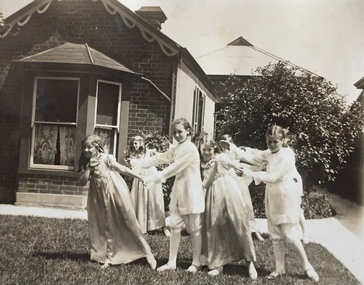
 Kew Historical Society Inc
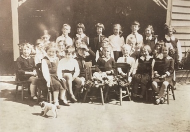
Photograph - Clarence Kindergarten and Sub-Primary, 180 Cotham Road, 1930-1935
180 Cotham Road, formerly 178 and later 210 Cotham Road, described as a brick residence of six rooms, was constructed in c.1890, for Alexander Hall, a dentist. From 1903, Miss Florrie Wymond operated a girls school at the property, and a timber schoolroom building was constructed at the rear of the property. During the 1930s, the school was known as the Clarence Primary School, and operated by Misses F L and M Wymond. While the listing of the property as a primary school had ceased by 1947, the Wymond family owned the property until the mid 1960s. (Source: Lovell Chen 2007, Review of B-graded buildings in Kew, Camberwell and Hawthorn).One of three photographs taken between 1930 and 1935 of students of 'Clarence' Kindergarten and Sub-Primary, located at 180 Cotham Road. The photos were accompanied by detailed notes identifying the names of students (where remembered).schools -- kew (vic.), clarence school, clarence house, 180 cotham road -- kew (vic.) -
 Kew Historical Society Inc
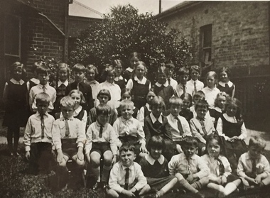
Photograph - Clarence Kindergarten and Sub-Primary, 180 Cotham Road, 1930-1935
180 Cotham Road, formerly 178 and later 210 Cotham Road, described as a brick residence of six rooms, was constructed in c.1890, for Alexander Hall, a dentist. From 1903, Miss Florrie Wymond operated a girls school at the property, and a timber schoolroom building was constructed at the rear of the property. During the 1930s, the school was known as the Clarence Primary School, and operated by Misses F L and M Wymond. While the listing of the property as a primary school had ceased by 1947, the Wymond family owned the property until the mid 1960s. (Source: Lovell Chen 2007, Review of B-graded buildings in Kew, Camberwell and Hawthorn).One of three photographs taken between 1930 and 1935 of students of 'Clarence' Kindergarten and Sub-Primary, located at 180 Cotham Road. The photos were accompanied by detailed notes identifying the names of students (where remembered).schools -- kew (vic.), clarence school, clarence house, 180 cotham road -- kew (vic.) -
 Kew Historical Society Inc
Photograph - Clarence Kindergarten and Sub-Primary, 180 Cotham Road, 1930-1935
180 Cotham Road, formerly 178 and later 210 Cotham Road, described as a brick residence of six rooms, was constructed in c.1890, for Alexander Hall, a dentist. From 1903, Miss Florrie Wymond operated a girls school at the property, and a timber schoolroom building was constructed at the rear of the property. During the 1930s, the school was known as the Clarence Primary School, and operated by Misses F L and M Wymond. While the listing of the property as a primary school had ceased by 1947, the Wymond family owned the property until the mid 1960s. (Source: Lovell Chen 2007, Review of B-graded buildings in Kew, Camberwell and Hawthorn).One of three photographs taken between 1930 and 1935 of students of 'Clarence' Kindergarten and Sub-Primary, located at 180 Cotham Road. The photos were accompanied by detailed notes identifying the names of students (where remembered).schools -- kew (vic.), clarence school, clarence house, 180 cotham road -- kew (vic.) -
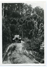 Orbost & District Historical Society
black and white photograph, 1924
History unknown. Oswald Stuart Green taught at the Bete Bolong State School in the 1920s /30s. He wrote many books about East Gippsland including several on thee Orbost / Marlo district.Oswald Green has an association with the Orbost area.A black / white photograph of a dirt road in the bush with a motor vehicle on the road and a man standing beside it.on back - " O.S. Green 31 Malcolm St Blackburn Princes Highway east of Coolwater Creek."princes-highway-coolwater-creek green-oswald-stuart -
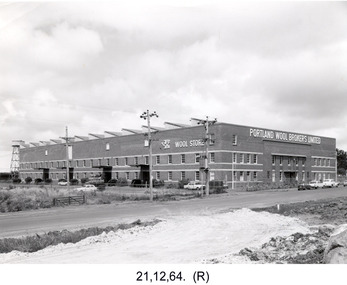 Glenelg Shire Council Cultural Collection
Photograph - Photograph - Portland Wool Brokers Limited, Wool Store, 1964
Port of Portland Authority archivesFront: (no inscriptions) Back: 12-8 Items date & 25½ [each ?] (blue pen, centre) 4572 (lower centre, pencil) Page 11 (lower right, blue pen) Film No. I.98/ Neg. No. 3/ Date 21-12-64/ (Portland Studios, 11 Julia St, Portland. Tel. 858 (blue stamp & pencil) (centre)port of portland archives -
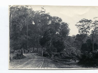 Orbost & District Historical Society
black and white photographs, late 19th century - early 20th century
3254.1 shows aTculvert over the gully at the foot of Burn’s Hill cutting at Newmerella and has been taken looking up tpward Burn's Cutting at Newmerella .Photograph 3254.2 has been taken from below the cutting. More information in Newsletter, November 2010.These photographs are pictorial records of Burn's Cutting and the old coach road in a time before the establishment of the Orbost to Bairnsdale railway line.Two black / white photographs of a gravel road on the side of a cutting. Both have a coach on the road. burn-road-newmerella cutting-newmerella coach-road-newmerella -
Whitehorse Historical Society Inc.
Document, Business Card, n.d
Business card for Thomas Scott, tinner and galvanizer of Victoria Road, Mitcham (now Rooks Road).scott, thomas, rooks road, mitcham -
 Whitehorse Historical Society Inc.
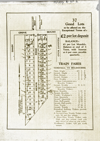
Document, 37 Good Lots
Brochure advertising 37 lots bounded by Mount Pleasant RoadBrochure advertising 37 lots bounded by Mount Pleasant Road, Menin Road and Shady GroveBrochure advertising 37 lots bounded by Mount Pleasant Roaddooland & goodchild, mount pleasant road, nunawading, menin road, shady grove -
Whitehorse Historical Society Inc.
Newspaper - Article, 575 Canterbury Road, Vermont, 3/08/1994
Canterbury Road, Vermont. Article on late 1950 weatherboard home at 575 Canterbury Road, Vermont.canterbury road, vermont, no 575 -
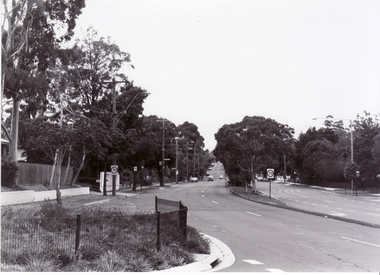
 Whitehorse Historical Society Inc.
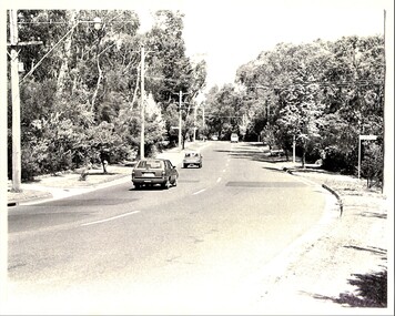
Photograph, Blackburn Road, 1983
Laser Print of black and white photo of Blackburn Road near Allendale Road, Blackburn. (Mounted)blackburn road, blackburn, alandale road, blackburn -
 Whitehorse Historical Society Inc.
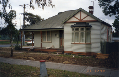
Photograph, Whitehorse Road Mitcham No.427, 21/12/2001 12:00:00 AM
Coloured photograph of 427 Whitehorse Road, Mitcham on the corner of Dunlavin Road. In process of being renovatedwhitehorse road, mitcham, no. 427 -
 Whitehorse Historical Society Inc.
Photograph, Canterbury Road, Blackburn, 6/01/2001 12:00:00 AM
Black and white photograph of Canterbury Road, Blackburn looking west from corner of Blackburn Road.canterbury road, blackburn., blackburn road -
 Whitehorse Historical Society Inc.
Photograph, Blackburn Road, Blackburn, 6/01/2001 12:00:00 AM
Black and white photograph of Blackburn Road, Blackburn South looking south from Canterbury Road.blackburn road, blackburn south, canterbury road -
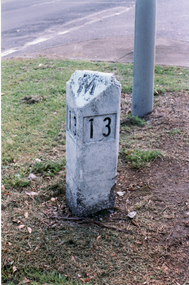 Whitehorse Historical Society Inc.
Photograph, Road Marker
Coloured photo of Road Marker on Median Strip, corner Whitehorse Road and Peel Street, Mitcham.whitehorse road, mitcham, peel street, road markers -
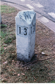 Whitehorse Historical Society Inc.
Photograph, Road Marker
Coloured photo of Road Marker on Median Strip, corner Whitehorse Road and Peel Street, Mitcham.whitehorse road, mitcham, peel street, road markers -
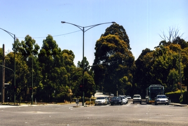 Whitehorse Historical Society Inc.
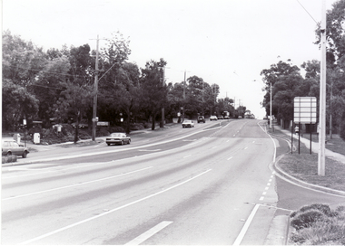
Photograph, Blackburn Road/Canterbury Road, Blackburn South, 2012
See NP4006Coloured photograph of Blackburn Road/Canterbury Road intersection. Cars coming from Blackburn - 2012blackburn road, blackburn south, canterbury road -
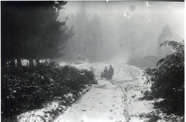 Mt Dandenong & District Historical Society Inc.
Photograph, Motorcycle and Sidecar in Snow, Olinda, c1921
A motorcycle with sidecar travelling down a snow covered road at Olinda. possibly Chalet Road. c1921.olinda, motorcycle, sidecar, snow, chalet road, iris woolrich -
Canterbury History Group
Photograph - Canterbury Road, c1970
Black & white photograph of Canterbury Road shops looking to the east from Balwyn Road. c1970.canterbury, canterbury road, carnell & sons, railway bridges -
Canterbury History Group
Photograph - View across Canterbury Road, corner of Rochester Road, towards Maling Road, Canterbury
Black and white photograph, corner of Canterbury and Rochester Roads looking towards Maling Road, Canterburycanterbury, canterbury road, maling road, rochester road, e.s.& a. bank, pharmacies, horses, horse drawn vehicles, kerbing and guttering -
 Ringwood and District Historical Society
Map - Plan of Subdivision, Part of Crown Section 24, Parish of Warrandyte, County of Evelyn - undated, circa 1951
Survey map of residential allotments in Milne Road, east of Berringa Road, Park Orchards, Victoria. -
Canterbury History Group
Photograph - Corner of shop No. 111 Maling Road at the corner of Maling Road and Theatre Place, Jan Pigot, 27/03/1993 12:00:00 AM
Coloured photograph of the corner of shop No. 111 Maling Road at the corner of Maling Road and Theatre Placecanterbury, maling road, shops, streetscapes -
Canterbury History Group
Photograph - Group of Maling Road traders in period costume posing for a photograph in Maling Road, Jan Pigot, 27/03/1993 12:00:00 AM
Coloured photograph of a group of Maling Road traders in period costume posing for a photograph in Maling Roadcanterbury, maling road, shops, fashion -
Canterbury History Group
Photograph - Group of Maling Road traders in period costume, Jan Pigot, 27/03/1993 12:00:00 AM
Coloured photograph of a group of Maling Road Traders in period costume posing for a photograph in maling Roadcanterbury, maling road, shop, fashion -
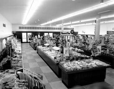 City of Kingston
Photograph - Black and white, c. 1956
This photograph depicts the interior of the Coles Variety Store within Bentleigh's Centre Road shopping precinct in 1956. Signage represents the pre decimal currency era. The Record Bar advertises the availability of standard and microgroove vinyl records.In this era, the Centre Road Bentleigh shopping strip provided consumers with access to many of the major retail outlets and provided for a wide range of shopping needs. By the 1960s, Chadstone Shopping Centres (opened 1960) and Southland (opened 1968) had been established which created changes to the way in which people shopped.Black and white photograph of interior of Coles Store in Centre Road, Bentleigh displaying prominent signage predating decimal currency. Other signage includes the Coles Record Bar indicating the sale of standard and microgroove vinyl records.Handwritten in blue ink: Coles Bentleigh Sep 1956 B Black printed text on white round adhesive sticker: 202 Handwritten in red ink: 80%shopping strip, strip shopping, bentleigh, city of moorabbin, coles stores -
Surrey Hills Historical Society Collection
Document - Contract of sale, Contract of sale for 33 Kingston Road, Surrey Hills
No 33 Kingston Road is a red brick attic-style house which was built c1920. Edward Edwards (1880-1963) was a blacksmith and the first owner. The house was named 'Berwyn' (Ref: 1931 electoral roll). Edward's wife was Mary Kennedy Stewart (1873-1931). They had 7 children, all born before the family came to Surrey Hills: 1. Hazel Margaret Kennedy Edwards (1896-1966) - dressmaker in 1931 electoral roll 2. Edward Alexander Edwards (1898-1988) 3. Mary Gwendolyn Edwards(1899-1942) 4. Gladys Annie Edwards (1902-1988) - hairdresser in 1931 electoral roll 5. Clarence Edwards (1906-1988) - plumber in 1931 electoral roll 6. Alan Stewart Edwards (1909 - 1996) 7. Geoffrey Ellis Edwards (1910-1985). The property passed to Edward Henderson Redpath after Edward Edward's death. He was a mechanic. (Ref: 1963 electoral roll). He was born in Shilbottle England on 3 December 1904 and married Gladys Annie Edwards in 1932 (#8417). He served in the Australian Airforce during WW2. Thus, the property was owned by the same family for over 40 years. Edward Henderson Redpath sold the property to David Murray Flynn and Heather Rosemary Flynn of 18 Kingston Road, Surrey Hills in 1965. Associated records: 1. Letter from George Henderson P/L to T Redpath, 1965 2. Letter re estate of E H Redpath, 1969. A standard folded real estate contract of sale for 33 Kingston Road, Surrey Hills, dated 14 August 1965edward edwards, berwyn, 33 kingston road, mary stewart kennedy, mary stewart edwards, houses, real estate contracts, legal documents, hazel margaret kennedy edwards, edward alexander edwards, mary gwendolyn edwards, gladys annie edwards, clarence edwards, alan stewart edwards, geoffrey ellis edwards, edward henderson redpath, gladys annie redpath, david murray flynn, heather rosemary flynn, house names