Showing 8487 items
matching snowy-river-dry-cleaners
-
 Eltham District Historical Society Inc
Photograph, Construction of Lower Plenty Bridge, Main Road, c.August 1966, 1966
This black and white photograph records construction activity of the then new Main Road bridge over the Plenty River at Lower Plenty in 1969.Local significanceBlack and white photograph taken during construction of the Main Road bridge over the Plenty River. Includes structural members, construction personnel, vehicles and a Clarke mobile crane.mobile cranes, bridge construction, main road, plenty river, lower plenty, bridges -
 Orbost & District Historical Society
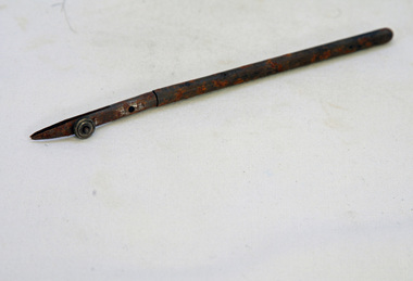
fence post, 1840's
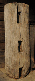
This fence post is from the original Snowy River Station stock yards which were where "Merindah" stands today. It was probably owned by the Marshall family at the time of transfer to "Merindah" in 1985. It was lifted out by Geoff Stevenson with a bucket on a tractor in 1986. The post was originally twice the length. The Snowy River Station was established in 1842 by Peter Imlay. In 1845 the land was sold to Norman MCLeod who named the area Orbost. After financial difficulties in the 1870's the run was taken over by W.J.Clarke and known as Orbost Station.Peter Imlay established the first white settlement in 1842 settling on the eastern side of the Snowy River where the township of Orbost now stands. This settlement was the Snowy River Station. A corner post from a post and rail fence. It is possibly made of red box.. On one side are three rectangular sections cut out with a similar one on the other sides. The post is hollow and has metal staples in the sides for attaching wires.orbost-station mcleod fence-post -
 Orbost & District Historical Society
book, Orbost Golf Club, 2006
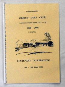
This book was produced as part of the centenary celebrations in 2006. In 2006 Orbost Golf Club celebrated its’ Centenary having originally been formed as the Snowy River Golf Club and played on private land near the banks of the Snowy River just to the south of town. In the 1930’s the Golf Club relocated to its present site and was renamed Orbost Golf Club. The land was shared by the Show grounds and Racing Club. Orbost Golf Club later acquired the land outright to provide a permanent home for golfers in Orbost and surrounding district.This is a local history book.A 38 pp spiral bound book titled Orbost Golf Club Centenary Booklet 1906-2006 Centenary Celebrations 9/12 2006. The front cover is cream and has a black line sketch of the old club house at Orbost Golf Club.recreation orbost-golf-club -
 Port of Echuca
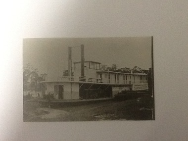
Black and white photograph, approx 1980
A closeup, black & white photo of the P.S. Captain Sturt moored by river bank. Captain Sturt is a two-funnelled, two storey boat with the wheelhouse above the 2nd storey. It appears the second storey is cabins. The original photo is part of the Price Collection.Black and white copy of a photograph of P. S. Captain Sturt moored by river bank. Copy of an original photograph (unknown date)In black pencil "Price, Captain Sturt, date unknown -
 Orbost & District Historical Society
display cabinet and tools
This display was put together by the Curlip Committee and used as promotion in the shed during the construction of Curlip 11 A community project, this boat was constructed out of local hardwood timbers utilizing the traditional skills of wooden boat builders and is powered by a steam engine. Paddle Steamer Curlip II is a replica of an historic paddle steamer of the Snowy River, in Far East Gippsland, Victoria. The original Paddle Steamer Curlip was built by Sam Richardson and his sons Mark, Albert and Frank, at their sawmill at Tabbara, a pioneering settlement on the Brodribb River, a tributary of the Snowy River. The keel was laid on 14th October 1889 and PS Curlip was launched in 1890. The name “ Curlip” is derived from the indigenous name for the area where Tabbara is located and includes land to the east of the Snowy and Brodribb Rivers towards Cape Conran. PS Curlip was registered in 1893 and the Passenger Certificate issued on 30th January 1903 to Captain Alan Richardson by the Marine Board of Victoria entitled her to carry 25 passengers and only 10 passengers when engaged in towage service. Two children under 12 years of age to be reckoned as one passenger. PS Curlip towed five barges at a time, traveling upstream as far as Bete Bolong, 20 km upstream of the mouth to collect produce to be transferred to schooners near Marlo. She towed vessels in and out through the Snowy river entrance and was also used for social functions such as Sunday School picnics. She was the main means of transport for imports and exports on the Snowy River for almost 30 years. The Curlip era ended abruptly on Friday 28th February when a flash flood carried her and 2 barges down river and out to sea, where she washed ashore at Marlo and broke up.More than eighty years after the original Paddle Steamer Curlip was wrecked at sea, the Orbost community launched a replica which it hoped would draw tourists to the region. The P.S. Curlip II, is based on drawings of the original Curlip that made its home in the Snowy and Brodribb Rivers of East Gippsland in the 1890s and early 1900s, It took six years of planning and hundreds of hours of volunteer work from the local community.A display cabinet containing tools and sundry items related to the Paddle Steamer Curlip. (More information on individual items in Catalogue 1400-1600)p.s.curlip richardson-samuel boat-building-tools transport -
 Orbost & District Historical Society
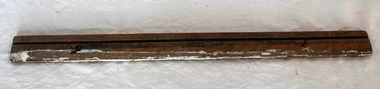
ruler, C 1930's
The Mundy family were farmers / settlers in the Snowy River area since c. 1880s. The original Mundy family moved to a land "selection" at Betebolong in the early 1880's from Buchan. John Mundy grew up in the Orbost district. This item highlights the comparison between today's educational equipment and those of the 1930's.A 15 inch wooden ruler with carvings and holes.On back - J. MUNDYmeasurement ruler mundy-family educational -
 Orbost & District Historical Society
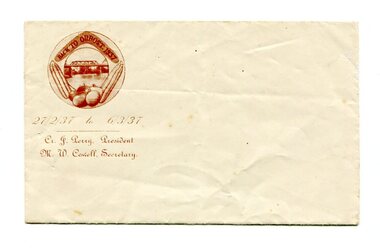
envelope, 1937
This envelope would have been made for the organising committee of the 1937 Back To Orbost celebration.This item was part of of a significant event held in Orbost. A small, white rectangular envelope. In the top left hand corner in dark brown is an illustration of maize, vegetables,a boomerang and the Snowy River Bridge enclosed in an oval frame. Inside the boomerang is "BACK TO ORBOST. 1937". Below is " 27 / 2 /39 to 6 / 3 /3" and below this is "Cr J. Perry President - M.W. Cowell secretary" printed in an ornate text..orbost-back-to-1937 envelope stationery -
 Port Melbourne Historical & Preservation Society
Document - Short Road Ferry ticket, c.1974
From the collection of Warren DOUBLEDAY. The short Road ferry ran between the end of Williamstown Road in Port Melbourne across the narrowest section of the Yarra River to the bottom of the Strand in Williamstown. The name came from it being the 'short road' between the two places. There was a type of ferry service in operation from around 1873 which was modernised in the 20th century to take cars and trucks across the river. It was operated by two heavy chains which sank to the river bed to allow ships to pass.A single trip 15 cent ticket for crossing the Yarra River from Williamstown on the Short Road Ferry. The off white ticket has two diagonal blue stripes and the number F 048261 printed on the side. transport - ferries, short road ferry, williamstown, transport - motor vehicles -
Federation University Historical Collection
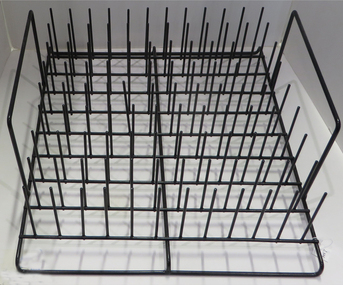
Equipment - Plate Dryer, Wooden photographic plate dryer
Used at Ballarat Technical Art School which is a predecessor of Federation University.Wooden rack with carved slots for placing photographic plates for drying 1/3 in lead pencil, plate drying rack, wooden rack, ballarat technical art school, plate drying -
Phillip Island and District Historical Society Inc.
Photograph
This photograph was taken by the Herald & Weekly Times and donated to Audrey McFee. Chicory was first grown on Phillip Island in 1870. It was used in coffee essence and for medicinal purposes.Jimmy McFee raking up chicory into elevator for drying floor.local history, photography, photographs, slides, film, chicory industry, black & white photograph, audrey mcfee, chicory, phillip island -
 Federation University Historical Collection
Object, Test Tube Drying Rack
These items were used at the Ballarat School of Mines Chemistry Laboratroy, which was dismantled in 2016.Black plastic covered metal test tube drying rack.chemistry, laboratory, scientific instruments, test tube drying rack -
 Glenelg Shire Council Cultural Collection
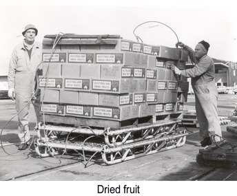
Photograph - Photograph - Boxes of Australian Dried Fruit prepared for lift, n.d
Port of Portland Authority archivesFront: (no inscriptions) Back: (no inscriptions)port of portland -
 Bendigo Historical Society Inc.
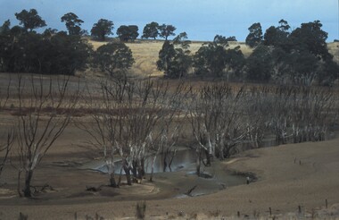
Slide - VAL DENSWORTH COLLECTION: DRY LAKE EPPALOCK, May 2004
Slide. Dry Lake Eppalock. A small pool of water in the Lake.slide, bendigo, dry lake eppalock., dry lake eppalock. -
 Bendigo Historical Society Inc.
Slide - VAL DENSWORTH COLLECTION: DRY LAKE EPPALOCK, May 2004
Slide. Dry Lake Eppalock. Pools of water in Lake Eppalock.slide, bendigo, dry lake eppalock., dry lake eppalock. -
 Numurkah & District Historical Society
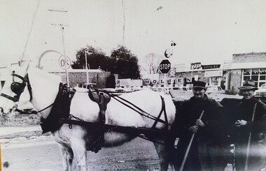
Photograph - Photo-Street cleaners, 1970's
Horse & Cart was used by Council Workers up until the early 1970's to clean street gutters.B&W photo of Shire cleaners with horse & cart, early 1970's. On the back: names of the two council workerssee photohorse, cart, shire workers, street cleaners, 1970's, photo -
 Mont De Lancey
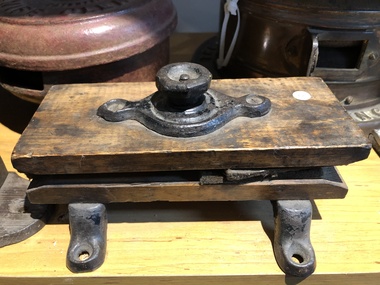
Knife Cleaner, Circa 1895
Cast iron and wood static type knife cleaner. Large screw connecting 2 pieces of wood. (Maker not shown).knife cleaners -
 Mont De Lancey
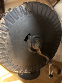
Knife Cleaner, Circa 1885
12" diameter hand-cranked tinplate and cast iron rotary disc, knife cleaner, with a wooden handle. (No Maker shown). -
 Melbourne Tram Museum
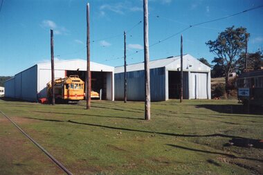
Photograph - Colour Print/s, Keith Kings, c1986
Colour of Track Cleaner No. 7 at the TMSV Museum Bylands, c1986. The TMSV subsequently sold the tram to the Perth Tramway Museum.trams, tramways, tmsv, bylands, museums, work trams, tram 7 -
 Melton City Libraries
Photograph, Melton Railway Bridge, c.1884
"The Melton Viaduct, opened in 1886, is of State heritage significance as a very large and visually distinctive wrought iron, lattice girder trestle bridge over the Werribee River (now Melton Reservoir). It comprises 18.3 and 9.1 metre spans, in a generally alternate arrangement, of total length 375 metres, and standing 38 metres over the Werribee River. Wrought iron small section iron was used to build tension trussed trestle legs, which supported four lines of rivetted wrought-iron deck-type double lattice trusses. It has bluestone abutments and pier bases of coursed rock-faced bluestone with drafted margins. The larger half-piers, now usually submerged in the Melton Reservoir have sharp tapered cutwaters and curved coping at the tops. While designed to carry two rail tracks it has only ever been used as a single track line. Despite several alterations to its deck structure, it remains an outstanding example of a lighter structural design employing open metal trestle supports and metal truss girders. The direct Melbourne to Ballarat railway link of which the Melton viaduct was the major engineering work contributed significantly to the history and development of Victoria. This new link reflected Ballarat’s diversifying economy as well as the commercial and political influence of the metropolis. Construction of the bridge, and the associated large workers camp, were extensively photographed, documenting an important episode in local history. The railway enabled the development of new industries in the Melton area, notably the timber industry and a chaff industry of national importance, greatly facilitated the later transition of the Shire from a pastoral to a farming economy, and struck a major blow to Melton township’s era as a wayside town servicing Ballarat road (especially coach) traffic". Melton Railway Bridge being built across the Werribee Rivertransport -
 Kew Historical Society Inc
Photograph - River Yarra in Flood from Kilby Road
Flooding of the Yarra Valley, including that section of the Yarra bordering Kew and Kew East in the north and west of the municipality, was a regular occurrence. Extreme flood events of the Yarra River are recorded to have occurred in 1891, 1901, 1916, 1923 and 1934. The Municipality of Kew's response to these floods was to enact planning decisions restricting residential development in flood prone areas following the floods of 1916, 1921 and 1934. While floods continued after the development of the Upper Yarra Reservoir (construction 1948-57), the regularity and extent of these inundations diminished.Print copy of an original photo of the River Yarra in Flood, taken from Kilby Road.VIEW ACROSS YARRA IN FLOOD / FROM KILBY RD KEWkilby road, floods -- kew (vic.), kilby farm -
 Kiewa Valley Historical Society
Maps - Tawonga and Feathertop
Plan of Tawonga showing roads etc, rivers, use of land in 1968 and of Feathertop in 1969.Historical use of land in Tawonga and Feathertop.1. Topographical Map - Tawonga 803 Forests Commission of Victoria 1968. Cream paper with black print. Legend: Roads, tracks etc, rivers, Parishes and use of land. 2. Feathertop 813. 1969tawonga map 1968, tawonga parishes, feathertop map 1969 -
Tatura Irrigation & Wartime Camps Museum
Photograph, Goulburn Weir, 1890
Taken by photographer for State Rivers and Water Supply Commission.Medium sized black and white photograph. Earthworks foreground, horse and dray lower right, men working on concrete weir structures, middle distance, - river with tree'd banks beyond, workmen's huts and house left of middle distancevictoria state rivers and water supply commission, goulburn weir -
 Orbost & District Historical Society
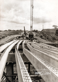
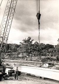
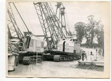
black and white photographs, 1974 - 1976
Construction of the roadway embankment between the bridges across the Snowy River flood plains at Orbost commenced in January 1974 and was completed in November 1976. Pearsons were the bridge contractors for the construction of the Princes Freeway and bridges across the river flood plains at Orbost. Heavy rains and floods held up progress.These photographs are of the construction of a major structure in Orbost. The opening of this Snowy River Bridge was an important development in the accessibility to the township of Orbost.Four black / white photographs of construction sites. 3241.1 is of three cranes and other machinery with six persons. 3241.2 is of workmen working on flooded site. 3241.3 is a photograph of the early stages of construction of a bridge looking towards the township. 3241.4 shows the construction of a roadway between the bridges.construction-snowy-river-bridge bridge-orbost -
 Federation University Historical Collection
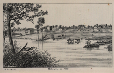
Image, John Helder Wedge, Melbourne in 1838, 1938
The following information is from http://melbourneday.com.au/about.html, accessed 30 August 2016 Melbourne was founded on 30 August 1835 by settlers who sailed from Van Diemen’s Land (Tasmania) aboard the schooner Enterprize. They landed on the north bank of the Yarra River and established the first permanent settlement, close to where the Immigration Museum at the Old Customs House — on the corner of William and Flinders Streets — stands and the place today known as Enterprize Park. Melbourne Day Committee was established to help correct the record about the founding of Melbourne and celebrate its anniversaries. The settlers came from Launceston in search of sheep-grazing land. Land had become expensive and there had long been stories told by whalers and sealers working in Bass Strait of fertile land to the north. This was the southern part of the colony of New South Wales, which the Colonial Government did not want settled at that time. After the Henty family crossed Bass Strait and settled at Portland in 1834 others quickly followed. The north bank was chosen because a small waterfall, or rapids, stopped further progress up the river. The waterfall also separated the tidal movement, providing a vital supply of fresh water. The site had previously been noted by the colony of New South Wales' surveyor, Charles Grimes, in 1803. The north bank also offered more stable, suitable ground. The people of the Kulin nation are the traditional owners of the land that became Melbourne — including the Boonwurrung, Woiwurrung, Taungurung and Djadjawurrung people, who gathered in this place for ceremonies and cultural activities. The topsail schooner Enterprize you see today is a full-size replica of the one that brought the settlers and has become a symbol of Melbourne Day. Her keel was laid at Polly Woodside Maritime Museum in 1991, and the $2.5 million, 27m vessel was launched by Felicity Kennett on 30 August, 1997, at Hobsons Bay. The original ship was bought by John Pascoe Fawkner in April 1835 specifically to search for a suitable place for a settlement in the Port Phillip District. After helping establish Melbourne, the original Enterprize continued operating as a coastal trading vessel for a number of years. She eventually disappeared off the shipping register in 1847, having been wrecked on a sand bar in the Richmond River in northern NSW, with the loss of two lives. The replica is managed by the Enterprize Ship Trust, a not-for-profit organisation. The first settlers were those on board the Enterprize — her crew and passengers. They were John Lancey , master mariner and Fawkner’s representative; Enterprize's captain, Peter Hunter; George Evans, plasterer/builder; carpenters William Jackson and Robert Hay Marr; Evan Evans, George Evans’ servant; and Fawkner’s servants ploughman Charles Wise, general servant Thomas Morgan, blacksmith James Gilbert and his pregnant wife, Mary. And Mary's cat! Enterprize set sail on her historic voyage from Launceston on July 21, 1835, stopping at George Town in northern Tasmania where creditors detained Fawkner. He was therefore not part of the first trip to Melbourne. Enterprize then left on August 1 under the command of captain Hunter. The expedition was led by Lancey, Fawkner's delegate. The party first considered Western Port and the eastern side of Port Phillip for a place to settle, before deciding on the Yarra’s north bank — known today as Enterprize Park. On Sunday, August 30, they disembarked and began to erect shelter, build a store and clear land to grow food, thus starting the permanent European settlement of Melbourne.Image of the fledgling town of Melbourne on the banks of the Yarra River. melbourne, yarra river, john helder wedge -
 Bendigo Historical Society Inc.
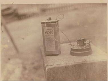
Photograph - BATTERY DEVICE
Black and white photo of dry battery connected by wires to small device mounted on circular base. All resting on wooden box. ' Mesco dry battttery' On back printed Post Card.topic, objects, battery -
 Kew Historical Society Inc
Photograph - Flooding of the Yarra River in North Kew, 1934
North Kew, now divided between Kew and Kew East, bordered the Yarra River. As such, it was a region subject to flooding in the Yarra Valley. Development beyond this point (ie Kellett Grove) was limited by the City of Kew's planning regulations. Prior to urban development, the area since European settlement and the first land sales in the district in the 1840s, had been used for dairy farming. .Small sepia snapshot of a local family's house in what was then River Avenue, North Kew being surrounded by floodwaters.Verso: THE SIDE OF RYANSyarra river -- north kew, floods -- yarra valley, floods -- north kew, floods -- 1934, natural disasters -- kew -
 Melbourne Tram Museum
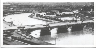
Photograph - Yarra River and Princes Bridge from Flinders St Station clock tower, Town and Country Journal, 1909
Photos show the Yarra river looking east over Princes Bridge. In both photos are cable trams, the rowing sheds and parts of Flinders St station. The first phtograph shows the nearly completed ramps from the platform, while the second has the former exit structure that allowed passengers to exit to Princes Bridge and St Kilda Road. Yields information about Yarra River, Flinders St railway station yards and Princes Bridge.Set of two photographs looking east from a Flinders St Station clocktower. over the Yarra River and Princes Bridge..1 – Melbourne Princes Bridge. Copy neg Mark Plummer collections ex late John Alfred collection. Has “T&C 20/12/09” in pencil on rear. .2 – Melbourne – Princes Bridge “Town and Country Journal 29/12/1909” Copy neg Mark Plummer collections ex late John Alfred collection.bridges, flinders st station, yarra river, railways, princes bridge, cable trams -
 City of Moorabbin Historical Society (Operating the Box Cottage Museum)
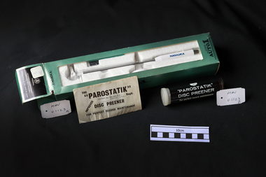
Manufactured Objects, Vinyl record cleaner kit 'NAGAOKA', c1970
a) Nagaoka Record Anti-Static & Disc Guard Kit The Nagaoka STAT-10 is a record protecting agent that serves both to protect your records from static and to significantly reduce record and stylus wear. By using this product you will improve the sound that you hear from your records, but will also protect your records. The unique charge reducing formula significantly reduces the amount of static electricity present on the surface of the vinyl recording. It also reduces the irritating noise produced by the scratches present on the surface of the vinyl recording. This record protecting agent also contains a special lubricant / protecting fluid agent.This lubricant / protecting fluid reduces record wear so that your recordings are as good as new. b) 'PAROSTATIK' Disc preener -: Use while rotating record slowly on Turntable. Press gently during one or two revolutions. Dust collected on plush surface should be removed before re-use. Device has "built-in" anti-static requiring occasional moisture replacement. Remove cap from centre tube withdraw and moisten wick (when dry) with clean water and replace Always return "Parostatik" to case when not in use. Vinyl records became very popular mid 20thC and cleaners were used to preserve the audio quality of the record surface.A box containing Vinyl record cleaning equipment manufactured by a) Nagaoka Pty Ltd Japan and b) 'Parostatik' C.E Watts Pty Ltd England a ) Box : NAGAOKA / A / trademark / NAGAOKA / AUTOMATIC RECORD CLEANER / ORIGINAL BEST PRODUCTS / NAGAOKA & CO LTD. MADE IN JAPAN / AUTOMATIC / RECORD CLEANER / AUTO 1 / NAGAOKA ORIGINAL BEST PRODUCTS b) Packet ; THE / "PAROSTATIK" PATENT .... REGD./ IMPROVED / DISC PREENER / FOR PERFECT RECORD MAINTENANCE Cylinder; Watts / "PAROSTATIK" / DISC PREENER / For perfect record maintenancerecord players, music, vinyl records, moorabbin, bentleigh, cheltenham, japan, nagaoka pty ltd ,, watts c. e. pty ltd, parostatik disc preener, england -
 Port of Echuca
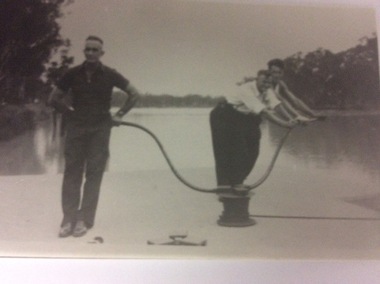
A black and white photograph of three men working on a lock, 20/09/1984
This photograph shows three men opening a lock, manually using a lock capstan. The men are fit and strong. The river behind them appears to be very high. Not sure what the era is, but is obviously before looks were mechanised. The devise they are using is called a lock capstan.This photograph shows how locks were manually opened to allow river transport to proceed. A black and white photograph of three men working on a lock somewhere on the Murray River in South Australia. The device they are using is called a lock capstan.Written on the back in lead pencil Price. Opening up lock -probably Lock 7, Renmark. Maybe Euston.locks, renmark, euston, price family collection, murray river, capstan, lock capstan