Showing 6374 items matching "system"
-
 Melbourne Tram Museum
Ephemera - MTA 30c tram ticket, The Met, c1984
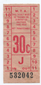
Sample of a Metropolitan Transit Authority 30c tram or bus ticket - red on off-white paper with a black number - No. 532042. Would have been issued soon after the MTA or The Met was formed and the start of many changes to the ticket system.Demonstrates tickets headed "MTA".30c MTA tram tickets - flimsy - paper, red colour on off white paper with number in black.tramways, tickets, mta -
 Bendigo Historical Society Inc.
Newspaper - JENNY FOLEY COLLECTION: TIME FOR A BREAK
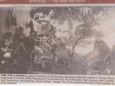
The inaugural meeting of the Bendigo Sewerage Authority was held in February 1917. It had government approval to borrow 5000 pounds for the initial setup including the provision of a sewerage treatment plan. Surveys for the provision of a sewerage system were first undertaken in 1916.Bendigo Advertiser ''The way we were'' from 2002. Time for a break: a gang of workers at the Bendigo Sewerage Authority located in Victoria Street, Eaglehawk, in the late 1950s. Pictured are Tom Atherton Sr, Roy Swinnerton, Saqm Angove, Allan Connally, Jack Swinnerton, Jim Kennedy, Charlie Wilson, 'Ganga' Ted Toon and Ernie Hartland. Photo supplied by Ernie Hartland. The clip is in a folder.newspaper, bendigo advertiser, the way we were -
 Melbourne Tram Museum
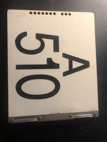
Functional object - Run Number Plate - Preston P41, Melbourne & Metropolitan Tramways Board (MMTB), 1960s
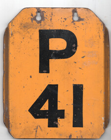
Used by East Preston Depot until they were phased out and replaced with the Automatic Vehicle Monitoring system c1990. Used to identify the depot and "run number" or timetable that the tram was running on, two in each tram, to enable monitoring by inspectors and crews.Demonstrates a MMTB Tram depot run number plate that was carried by each tram when in service.Pressed metal plate with corners trimmed, top section partly folded with two slotted holes, sides folded to give strengthening to the plate, painted with a yellow background and the letter "P" and numbers "41"painted in black, to give a Run Number Plate for East Preston Depot. Painted with the same detail on either side of the plate.trams, tramways, east preston depot, mmtb, timetables -
 Melbourne Tram Museum
Document, Melbourne & Metropolitan Tramways Board (MMTB), Melbourne cable tram history, late 1930's
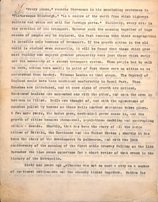
Manuscript - 29 quarto sheets carbon copy - article for publication possibly about the history of the Melbourne cable tram system. Notes cover - the background of history of city transport, the suburban councils, the formation of the MTOC, the MTT - list the various council representatives, development of the cable system, Mr. George Duncan, Dunedin, construction works, maintenance, finances, funding, contractors, construction timing, list of lines and opening dates, winding houses, the various lines, construction issues with drainage, cable lengths, horse trams. The conversion of cable trams, annual returns for 1886 to 1935. Page 22 has a heading "Why a Prophecy was Unfulfilled" - which looks at the finances of the MTT and the folding into the Tramway Board and then the MMTB, including community obligations, the MMTB Act, conversion operations, the Chairman's tour of 1923, St Kilda Road conversion, and finally conversion of Elizabeth St and Victoria St. Article dated mid to late 1930's.trams, tramways, cable trams, melbourne, public transport, history, mto co, mtt, dunedin tramways, finances, contracts, cables, construction, track construction, conversion, mmtb, chairman, community services -
 Melbourne Tram Museum
Functional object - Run Number Plate, Melbourne & Metropolitan Tramways Board (MMTB), AVM type, 1980's
Set of 2 run number plates used for the vehicle identification system used in the AVM. Item was pushed into a slot of a reader which then recognised the identification through the series of holes on the left hand side. Fitted with metal strips, riveted on, to enable the card to be slotted into the holder by the crew member and then withdrawn when not required. Understood that the tram carried one of these at one end and then another without the holes at the other end. Number has been engraved into the plastic sheet and then painted in black. Used to identify the depot and "run number" or timetable that the tram was running on, two in each tram, to enable monitoring by inspectors and crews. System introduced by the MTA during the second half of the 1980's. These two particular plates have details on how to be used in trams and they were used for transporting trams to and from the workshops. Have a label on the rear advising this. .1 - A150 .2 - E25 - (was this a duplicate of 1435.1?) - not all the holes have been fully drilled through.trams, tramways, mmtb, preston depot, timetables, preston workshops, south melbourne depot -
 Melbourne Tram Museum
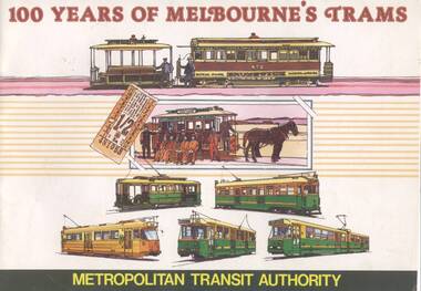
Book, G. McEldowney, "100 years of Melbourne's Trams", Nov. 1985
Thirty Two page book, A4 landscape format, saddle stapled, titled "100 years of Melbourne's Trams", published by the Metropolitan Transit Authority and the Australian Tramway and Motor Omnibus Employees Association in 1985. Colour cover featuring drawings of Melbourne trams from cable trams to articulated electric trams. Has foreword by Tom Roper, Minister for Transport. Book published to celebrate the centenary of the opening of the first cable tram in Melbourne, 11/11/1885. Reviews the history of trams in Melbourne, cable trams, horse trams, Clapp, municipal tramways, electric trams, MMTB, buses, Preston Workshops, Wattle Park and the Metropolitan Transit Authority. Notes the MTA winning the tender to building the Kowloon - Canton Light Rail system and Melbourne's Automatic Vehicle Monitoring System. Has colour photos and sepia toned (black and white) photos throughout. Second copy added 26-6-17 from donation of Neil Elfick.trams, tramways, melbourne, mmtb, cable trams, mta, horse trams -
 Nhill Aviation Heritage Centre
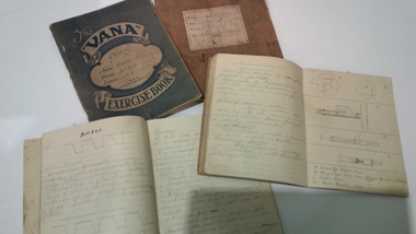
Memorabilia - Collection of four exercise books containing study notes for aircraft fitter and rigger
Study notes handwritten by by R.W.Harris while doing a Fitter's Course 159, Wing No 1 at IES Ascot Vale, Melbourne 1939-1945 Notes refer to Kitty Hawk , Bristol Beaufort , Wirraway, Avro Anson, metal rigging, systems etc Various exercise books, ruled with handwritten notes and diagramsR.W.Harris 52618 IES No 1 Wingr.w harris, fitters training notes, ies ascot vale, world war 2 -
 National Wool Museum
Book, Geelong Woolcombing Ltd: achieving excellence
"Geelong Wool Combing Ltd: achieving excellence" c.1997. Promotional brochure re: the operation of Geelong Wool Combing Ltd and its environmental and quality control systems which have enabled it to achieve ISO 9002 and ISO 14001 standards.wool processing, geelong wool combing ltd, combing -
 Ballarat Tramway Museum
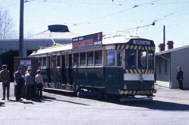
Photograph - Digital Image, Greg Triplett, No 40 the very last tram entering the depot building-The End - Greg Triplett, 19-9-1971
No 40 the very last tram entering the depot building. After the tram entered the building, the doors closed and a sign saying "The End" was shown. Greg Triplett Taken on the last day of operation of the SEC Ballarat tramway system - 19-9-1971. Yields information about the last day of operation of the Ballarat SEC tramways.Digital image - 120 negative tramways, tramcars, ballarat, last day, closure, tram 40, last tram, ballarat depot -
Ballarat Tramway Museum
Document - Tramcar Record - SEC No. 37 (2nd), Wal Jack, 1950's
Tamcar record for SEC Ballarat No. 37, builder, system location, short history and work in Ballarat. This was the second tram in Ballarat to carry this number. Was Bendigo 1 and swapped for two single truckers during 1960. See item 5548 for the first No. 37.Yields information about the history of individual tramcars in Ballarat.Handwritten note on foolscap lined sheet outlining the history of Ballarat Tramcar No. 37, the 2nd tram with this number, who built for, date to Ballarat, painting and other changes to the tramcar as compiled by Wal Jack. Part of a series on each SEC Ballarat operated tramcar, except for the ESCo trams. Contained within Reg Item 5507 - Foolscap binder with green covers, black binding edge, and metal clips. See image 7764 for the arrival of No. 1 ex-Bendigo.trams, tramways, ballarat, tramcars, tramcars of ballarat, tram 37 -
 Ballarat Tramway Museum
Slide - Tram 35 leaving the depot, Paul Jenkins, September 1971
Colour slide, of tram No. 35 leaving the depot, possibly on Sunday afternoon 19 September 1971, the day of the final closure of the SEC system, given the shadows and the tram destination. Trams ran as Special to Hospital Corner before picking up passengers. Demonstrates tram operations prior to closure of the SEC operated system.Kodachrome cardboard slide.tramways, ballarat, trams, sec depot, closure, tram 35, wendouree parade -
 Kew Historical Society Inc
Map, MMBW, MMBW Town of Kew, 1910-21
The Melbourne and Metropolitan Board of Works (MMBW) was established by an act of the Victorian Parliament in 1890 to prepare for and to implement a sewerage and water reticulation system across what was then inner Melbourne, its surrounding and middle distance suburbs, including Kew. The MMBW was disbanded in 1991.The map collection of the Kew Historical Society has at its core the historic maps assembled and originally stored in the City Engineer's Department of the City of Kew. These include maps in a number of scales. The vast majority of maps were produced by the MMBW in the first two decades of the twentieth century, and are solid working maps, backed by linen for durability. These maps are historically significant to Kew, the City of Boroondara and to the history of the development of state utilities in Victoria. A number of the Kew maps have additional details added by former municipal officers, including the levels reached by various floods. As these were working documents, information was added to them long after the period of their initial production and distribution.Early map of the Town of Kew, created after 1910, at a scale 440 ft to 1 inch. The 'assembled' map by the City of Kew Engineer's Department includes scaled down copies of The Melbourne and Metropolitan Board of Works maps, Nos. 39, 40, 64, 65, 66, 67, 68, and 117. The map covers the entirety of the Town of Kew, bordered on its north and west by the River Yarra, by Burke Road in the East and Barkers Road in the south. The map shows the extent of urban development by that time, prominent institutions and the outlines of built structures in the municipality. TOWN OF KEW / SCALE 400 FEET TO 1 INCHmelbourne & metropolitan board of works, mmbw maps, mmbw plans, town of kew, cartography -
 Kew Historical Society Inc
Map, MMBW, MMBW Plan No.39 Kew & Heidelberg, 1900-1910
The Melbourne and Metropolitan Board of Works (MMBW) was established by an act of the Victorian Parliament in 1890 to prepare for and to implement a sewerage and water reticulation system across what was then inner Melbourne, its surrounding and middle distance suburbs, including Kew. The MMBW was disbanded in 1991.The map collection of the Kew Historical Society has at its core the historic maps assembled and originally stored in the City Engineer's Department of the City of Kew. These include maps in a number of scales. The vast majority of maps were produced by the MMBW in the first two decades of the twentieth century, and are solid working maps, backed by linen for durability. These maps are historically significant to Kew, the City of Boroondara and to the history of the development of state utilities in Victoria. A number of the Kew maps have additional details added by former municipal officers, including the levels reached by various floods. As these were working documents, information was added to them long after the period of their initial production and distribution.Early map of part of the Borough of Kew, created in the first decade of the twentieth century, at a scale 160 ft to 1 inch. The map covers what was then the north western section of Kew, bordered on its north by Wills Street and the Kew Lunatic Asylum, in the west by the River Yarra [and the later added Yarra Boulevard] , by Princess Street in the East and Holroyd Street in the south. The map shows the extent of urban development by that time, prominent institutions and the outlines of built structures in the municipality. Contour lines were added in ink to the map at a later stage.MELBOURNE AND METROPOLITAN BOARD OF WORKS / PLAN NO. 39 / KEW & HEIDELBERGmelbourne & metropolitan board of works, mmbw maps, mmbw plans, borough of kew, cartography -
 Kew Historical Society Inc
Map, MMBW, MMBW Plan No.40 Collingwood & Kew, 1900-1910
The Melbourne and Metropolitan Board of Works (MMBW) was established by an act of the Victorian Parliament in 1890 to prepare for and to implement a sewerage and water reticulation system across what was then inner Melbourne, its surrounding and middle distance suburbs, including Kew. The MMBW was disbanded in 1991.The map collection of the Kew Historical Society has at its core the historic maps assembled and originally stored in the City Engineer's Department of the City of Kew. These include maps in a number of scales. The vast majority of maps were produced by the MMBW in the first two decades of the twentieth century, and are solid working maps, backed by linen for durability. These maps are historically significant to Kew, the City of Boroondara and to the history of the development of state utilities in Victoria. A number of the Kew maps have additional details added by former municipal officers, including the levels reached by various floods. As these were working documents, information was added to them long after the period of their initial production and distribution.Early map of part of the Borough of Kew, created in the first decade of the twentieth century, at a scale 160 ft to 1 inch. The map covers what was then the south western section of Kew, bordered on its north by Studley Park Road, in the west by Walmer Street and the River Yarra, by High Street South and Princess Street in the East and Barkers Road in the south. The map shows the extent of urban development by that time, prominent institutions and the outlines of built structures in the municipality. Contour lines and historic flood levels were added in ink to the map at a later stage.MELBOURNE AND METROPOLITAN BOARD OF WORKS / PLAN NO. 40 / COLLINGWOOD & KEWmelbourne & metropolitan board of works, mmbw maps, mmbw plans, borough of kew, cartography -
 Kew Historical Society Inc
Map, MMBW, MMBW Plan No.64 Kew & Heidelberg, 1900-1910
The Melbourne and Metropolitan Board of Works (MMBW) was established by an act of the Victorian Parliament in 1890 to prepare for and to implement a sewerage and water reticulation system across what was then inner Melbourne, its surrounding and middle distance suburbs, including Kew. The MMBW was disbanded in 1991.The map collection of the Kew Historical Society has at its core the historic maps assembled and originally stored in the City Engineer's Department of the City of Kew. These include maps in a number of scales. The vast majority of maps were produced by the MMBW in the first two decades of the twentieth century, and are solid working maps, backed by linen for durability. These maps are historically significant to Kew, the City of Boroondara and to the history of the development of state utilities in Victoria. A number of the Kew maps have additional details added by former municipal officers, including the levels reached by various floods. As these were working documents, information was added to them long after the period of their initial production and distribution.Early map of part of the Borough of Kew, created in the first decade of the twentieth century, at a scale 160 ft to 1 inch. The map covers what was then the northern most part of Kew, bordered on its north and west by the Yarra River, in the East by Connor's Creek and by the Asylum in the south. The map shows the extent of urban development by that time, prominent institutions and the outlines of built structures in the municipality. Contour lines and historic flood levels were added in ink to the map at a later stage.MELBOURNE AND METROPOLITAN BOARD OF WORKS / PLAN NO. 64 / KEW & HEIDELBERGmelbourne & metropolitan board of works, mmbw maps, mmbw plans, borough of kew, cartography -
 Kew Historical Society Inc
Map, MMBW, MMBW Plan No.65 Kew & Heidelberg, 1900-1910
The Melbourne and Metropolitan Board of Works (MMBW) was established by an act of the Victorian Parliament in 1890 to prepare for and to implement a sewerage and water reticulation system across what was then inner Melbourne, its surrounding and middle distance suburbs, including Kew. The MMBW was disbanded in 1991.The map collection of the Kew Historical Society has at its core the historic maps assembled and originally stored in the City Engineer's Department of the City of Kew. These include maps in a number of scales. The vast majority of maps were produced by the MMBW in the first two decades of the twentieth century, and are solid working maps, backed by linen for durability. These maps are historically significant to Kew, the City of Boroondara and to the history of the development of state utilities in Victoria. A number of the Kew maps have additional details added by former municipal officers, including the levels reached by various floods. As these were working documents, information was added to them long after the period of their initial production and distribution.Early map of part of the Borough of Kew, created in the first decade of the twentieth century, at a scale 160 ft to 1 inch. The map covers what was then the south central part of Kew, bordered on its north by Malmsbury Street, in the west by Florence Avenue, in the south by Barkers Road, and in the east by Princess Street. The map shows the extent of urban development by that time, prominent institutions and the outlines of built structures in the municipality. Contour lines were added in ink to the map at a later stage.MELBOURNE AND METROPOLITAN BOARD OF WORKS / PLAN NO. 65 / KEW & HEIDELBERGmelbourne & metropolitan board of works, mmbw maps, mmbw plans, borough of kew, cartography -
 Kew Historical Society Inc
Map, MMBW, MMBW Plan No.66 Kew, 1900-1910
The Melbourne and Metropolitan Board of Works (MMBW) was established by an act of the Victorian Parliament in 1890 to prepare for and to implement a sewerage and water reticulation system across what was then inner Melbourne, its surrounding and middle distance suburbs, including Kew. The MMBW was disbanded in 1991.The map collection of the Kew Historical Society has at its core the historic maps assembled and originally stored in the City Engineer's Department of the City of Kew. These include maps in a number of scales. The vast majority of maps were produced by the MMBW in the first two decades of the twentieth century, and are solid working maps, backed by linen for durability. These maps are historically significant to Kew, the City of Boroondara and to the history of the development of state utilities in Victoria. A number of the Kew maps have additional details added by former municipal officers, including the levels reached by various floods. As these were working documents, information was added to them long after the period of their initial production and distribution.Early map of part of the Borough of Kew, created in the first decade of the twentieth century, at a scale 160 ft to 1 inch. The map covers what was then the south eastern part of Kew, bordered on its north by Adeney Avenue, in the west by Sackville Street, in the south by Barkers Road, and in the east by Burke Road. The map shows the extent of urban development by that time, prominent institutions and the outlines of built structures in the municipality. Contour lines were added in ink to the map at a later stage.MELBOURNE AND METROPOLITAN BOARD OF WORKS / PLAN NO. 66 / KEW melbourne & metropolitan board of works, mmbw maps, mmbw plans, borough of kew, cartography -
 Kew Historical Society Inc
Map, MMBW, MMBW Plan No.67 Kew, 1900-1910
The Melbourne and Metropolitan Board of Works (MMBW) was established by an act of the Victorian Parliament in 1890 to prepare for and to implement a sewerage and water reticulation system across what was then inner Melbourne, its surrounding and middle distance suburbs, including Kew. The MMBW was disbanded in 1991.The map collection of the Kew Historical Society has at its core the historic maps assembled and originally stored in the City Engineer's Department of the City of Kew. These include maps in a number of scales. The vast majority of maps were produced by the MMBW in the first two decades of the twentieth century, and are solid working maps, backed by linen for durability. These maps are historically significant to Kew, the City of Boroondara and to the history of the development of state utilities in Victoria. A number of the Kew maps have additional details added by former municipal officers, including the levels reached by various floods. As these were working documents, information was added to them long after the period of their initial production and distribution.Early map of part of the Borough of Kew, created in the first decade of the twentieth century, at a scale 160 ft to 1 inch. The map covers what was then the north central part of Kew, bordered on its north by the Outer Circle Railway Spruzen and Beresford Avenues, in the west by Princess Street, in the south by High Street, and in the east by (about) Belford Road. The map shows the extent of urban development by that time, prominent institutions and the outlines of built structures in the municipality. Contour lines were added in ink to the map at a later stage.MELBOURNE AND METROPOLITAN BOARD OF WORKS / PLAN NO. 67 / KEW melbourne & metropolitan board of works, mmbw maps, mmbw plans, borough of kew, cartography -
 Kew Historical Society Inc
Map, MMBW, MMBW Plan No.68 Kew, 1900-1910
The Melbourne and Metropolitan Board of Works (MMBW) was established by an act of the Victorian Parliament in 1890 to prepare for and to implement a sewerage and water reticulation system across what was then inner Melbourne, its surrounding and middle distance suburbs, including Kew. The MMBW was disbanded in 1991.The map collection of the Kew Historical Society has at its core the historic maps assembled and originally stored in the City Engineer's Department of the City of Kew. These include maps in a number of scales. The vast majority of maps were produced by the MMBW in the first two decades of the twentieth century, and are solid working maps, backed by linen for durability. These maps are historically significant to Kew, the City of Boroondara and to the history of the development of state utilities in Victoria. A number of the Kew maps have additional details added by former municipal officers, including the levels reached by various floods. As these were working documents, information was added to them long after the period of their initial production and distribution.Early map of part of the Borough of Kew, created in the first decade of the twentieth century, at a scale 160 ft to 1 inch. The map covers what was then the north central part of Kew, bordered in the north by Oak Avenue, in the west by the Yarra River and Connor's Creek, in the south by Beresford and Carnegie Avenues, and in the east by Glass's Creek and Burke Road. The map shows the extent of urban development by that time, prominent institutions and the outlines of built structures in the municipality. Contour lines and the levels of historic floods were added in ink to the map at a later stage.MELBOURNE AND METROPOLITAN BOARD OF WORKS / PLAN NO. 68 / KEW melbourne & metropolitan board of works, mmbw maps, mmbw plans, borough of kew, cartography -
 Kew Historical Society Inc
Map, MMBW, MMBW Plan No.117 Heidelberg & Kew, 1900-1910
The Melbourne and Metropolitan Board of Works (MMBW) was established by an act of the Victorian Parliament in 1890 to prepare for and to implement a sewerage and water reticulation system across what was then inner Melbourne, its surrounding and middle distance suburbs, including Kew. The MMBW was disbanded in 1991.The map collection of the Kew Historical Society has at its core the historic maps assembled and originally stored in the City Engineer's Department of the City of Kew. These include maps in a number of scales. The vast majority of maps were produced by the MMBW in the first two decades of the twentieth century, and are solid working maps, backed by linen for durability. These maps are historically significant to Kew, the City of Boroondara and to the history of the development of state utilities in Victoria. A number of the Kew maps have additional details added by former municipal officers, including the levels reached by various floods. As these were working documents, information was added to them long after the period of their initial production and distribution.Early map of part of the Borough of Kew, created in the early twentieth century, at a scale 160 ft to 1 inch. The map covers what was then the north eastern part of Kew showing the natural landscape and limited development on the south side of the Yarra River. In the Kew section, south of the river, the land is occupied currently by the Greenacres and Kew Golf Clubs. The map shows the extent of urban development by that time and the outlines of the few built structures in the municipality. The height above sea level of all parts of the landscape are indicated numerically in feet. Contour lines and the levels of historic floods were added in ink to the map at a later stage. MELBOURNE AND METROPOLITAN BOARD OF WORKS / PLAN NO. 117 / HEIDELBERG & KEW melbourne & metropolitan board of works, mmbw maps, borough of kew, cartography, mmbw plan no. 117, kew (vic.) -- maps, heidelberg (vic.) -- maps -
 Kew Historical Society Inc
Map, MMBW, River Yarra Beautification Schemes, c.1913
The Melbourne and Metropolitan Board of Works (MMBW) was established by an act of the Victorian Parliament in 1890 to prepare for and to implement a sewerage and water reticulation system across what was then inner Melbourne, its surrounding and middle distance suburbs, including Kew. The MMBW was disbanded in 1991.The map collection of the Kew Historical Society has at its core the historic maps assembled and originally stored in the City Engineer's Department of the City of Kew. These include maps in a number of scales. The vast majority of maps were produced by the MMBW in the first two decades of the twentieth century, and are solid working maps, backed by linen for durability. These maps are historically significant to Kew, the City of Boroondara and to the history of the development of state utilities in Victoria. A number of the Kew maps have additional details added by former municipal officers, including the levels reached by various floods. As these were working documents, information was added to them long after the period of their initial production and distribution.Map of the City of Kew showing part of the River Yarra Beautification Schemes. The map shows development to date and the flood levels reached in 1923 and 1924. This map may have been adapted from an earlier map, as most development in central Kew and Studley Park had occurred by this date yet numerous streets are not represented. Public buildings and institutions are clearly represented and named on the map as are significant public transport infrastructure (eg the Outer Circle railway).MELBOURNE AND METROPOLITAN BOARD OF WORKS / RIVER YARRA BEAUTIFICATION SCHEMES / SCHEME / SCALE 10 CHAINS TO AN INCHmelbourne & metropolitan board of works, mmbw maps, mmbw plans, city of kew, flood levels -- kew (vic.), cartography -
Woodend RSL
Headwear - Australian Light Anti-Gas (ALAG) respirator Haversack, MH & Co
The haversack is the brown version (as opposed to the tropical version) issued by the Australian army. Designed inspired from the British haversack with the Australian using a Lift The Dot system instead of a pull tab. This model uses the same ring strap connector as the British haversack.The object is representative of military light gas mask pouch circa mid 20th century.Of rectangular parallelepipped shape made of thick and sturdy fabric (canvas). The colour is faded to a very pale shade of green. Some patches of original colour remain under the pocket flaps showing a darker shade of green. Front view - Rectangular shape with overlapping closing flap with a fastener to maintain closed Left and right views - Both sides have a small pocket attached. Pockets are maintained closed with a press-stud There is a metal buckle on top of the small pockets to attach a lanyard (using items 2020.000018-2 & 2020.000018-3). Back view - Rectangular with metal hooks on top and bottom to enable attachment to a strap/webbing. Bottom view - ‘U’ shaped stitching apparent (for internal pocket) with a metal stud slightly off center of the base (enabling closing of the internal pocket). Top view - closing flap overlapping on 3 sides and attached to the fabric forming the back part of the pouch. Inside view - On the inside, there is a small pocket at the bottom closed with a press-stud. There is also a loop of fabric fastened with another metallic press-stud. There is also an insert against the back pannel (full heighth of the pannel).The fastener of the main cover flap has "LIFT THE DOT" inscribed on the outside. Contains the Department of Defense symbol on the inside of the cover flap. -
 Melbourne Legacy
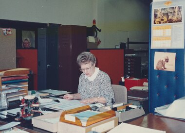
Photograph, Legacy House Office, 1992
A photo of the administrative office area of Legacy House in 1992. Note the paper based system and lack of computers. Staff member's name is not known. Was with photos from 1992 so the date is early that year based on the months January and February showing on the calendar.A record of administration area of Legacy in the 1990s.Photo of a staff member at her desk in Legacy house in 1992.staff, office -
 Melbourne Tram Museum
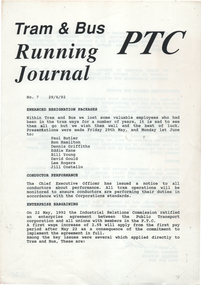
Newsletter, Public Transport Corporation (PTC), "Tram & Bus Running Journal PTC" - No. 7, 29/6/1992
"Tram & Bus Running Journal PTC" - No. 7 - dated 29/6/1992. Has items on enhanced resignation packages, conductor performance, enterprise bargaining, OH&S and Hastus - crew rostering system. Signed by Russell Nathan as General Manager.Demonstrates PTC newsletter of 1992 regarding employees.Printed A4 double sided sheet.tramways, ptc, conductors, oh&s, hastus, retrenchment -
 Federation University Art Collection
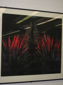
Drawing, Stratford, Noella, 'Avenue of Desire' by Noela Stratford, 2005
Noela STRATFORD Dr Noela Stratford explores Australian landscapes, and considers their contextual systems in her personal interpretations. This item is part of the Federation University Art Collection. The Art Collection features over 2000 works and was listed as a 'Ballarat Treasure' in 2007.A framed drawing of agave plants along an isolated place in southern Spain. art, artwork, noella stratford, flowers, flora, spain, agave, noela stratford -
 Ballarat Tramway Museum
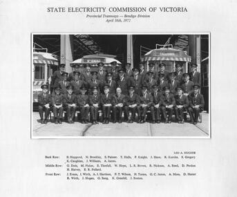
Photograph - SEC Bendigo Traffic staff at closure, 16/4/1972
Photograph of the traffic or trammies with their names underneath at the time of the closure of the SEC-operated Bendigo Tram system 16/4/1972. Four of the Bendigo trams behind the group were photographed in front of the depot building. See item 1185 for similar photographs.Has a close association with Bendigo Tramway staff at the time of closure of the SEC operated system.Black and white photograph mounted onto heavy card with a list of names underneath.bendigo, sec crews, personnell, staff photo, group photo. -
 Melbourne Tram Museum
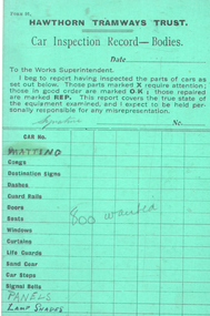
Administrative record - Form, Hawthorn Tramways Trust (HTT), "Car Inspection Record - Bodies", c1920
Hawthorn Tramways Trust form No. 91, recording the inspection, and repair work needed on the body of tramcars. Has been marked up in pencil for changes to the layout, possibly at the time of the takeover of the Trust by the MMTB and the formation of the Eastern System. Notes 800 wanted.Demonstrates an HTT tramcar maintenance form.Printed form on green card - form No. 91tramways, htt, forms, tramcar maintenance, tramcar inspection -
 Melbourne Tram Museum
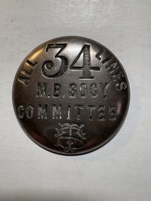
Badge - "M.B. Socy Committee 34 - All lines", Tramway Board, 1910s
Use to identify a Tramways Medical Benefit Society Committee Member and available for free travel on all lines on the Tramway Board and MMTB systems. The Medical Benefit Society or Tramway Friendly Society provided mutual benefit funds for cable tramway employees.Demonstrates the method of identifying Medical Benefit Society Committee members and providing them with free travel.Round pressed brass badge with the words "M.B. Socy Committee" pressed into the centre of the badge, and around the top part "34 - All lines" and the Tramway Board logo on the bottom. Two lugs have been soldered onto the rear to enable a leather strap to be fitted. Traces of black enamel paint that infilled the words remain. Second copy - slightly different layout - No. "7"badges, mmtb, cable trams, tramway board, medical, tbs -
 Melbourne Tram Museum
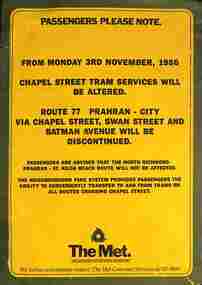
Sign - Route 77 - Prahran discontinued, The Met, Nov. 1986
Sign advising passengers that the Route 77 Prahran to City - Batman Ave via Chapel St service will be discontinued from 3/11/1986. Published by The Met. Notes that the Neighbourhood Fare System allows for transfers to and from Chapel St trams.Yields information about the closure or discontinuance of route 77 trams in 1986.Sign - printed A4 sheet with remnants of adhesive on rear.trams, tramways, the met, chapel st, route 77 -
 Federation University Historical Collection
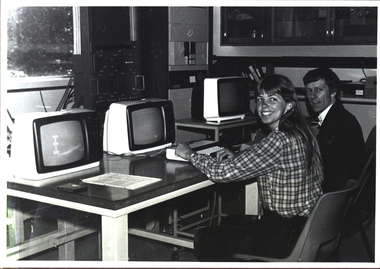
Photograph - Computers, Applied Physics MicroBee Computer, 1983
MicroBee was a series of networkable home computers by Applied Technology, which became publicly listed company MicroBee Systems Limited soon after its release. The original Microbee computer was designed in Australia by a team including Owen Hill and Matthew Starr. The MicroBee's most distinctive features are its user configurable video display and its battery backed non-volatile RAM and small size allowing it to be powered off, transported, and powered back on and resume activities on the currently loaded program or document. It was originally packaged as a two board unit with the lower "baseboard" containing all components except the system memory which was mounted on the upper "core board". (Wikipedia).1) Ballarat College of Advanced Education Applied Science students demonstrate the use of the Applied Physics MicroBee Computer. .2) Jenny Simkin and Graeme Clark demonstrate the Microbee in Applied Physics at the Ballarat College of Advanced Education in August 1983. The MicroBee interfaced to radio, and assisted in finding messages via Amateur Radio (note the transceiver and RTTY interface VK3NV) An audio cassette for program and data storage is located to the right behind the keyboard. .1) verso Ballarat CAE Applied Science students test 'Microbee' computers which are used by students staking studies in Applied Physics. Frances, would be grateful if this could be returned. Thank you Mike .2 verso Jenny Simpkin Graeme Clark Microcomputer/Radioteletype demo App Physics Aug '83ballarat college of advanced education, jenny simpkin, graeme clark, microbee computer, physics, applied scinece, computer science, computers