Showing 4019 items
matching railway stations
-
 Melbourne Tram Museum
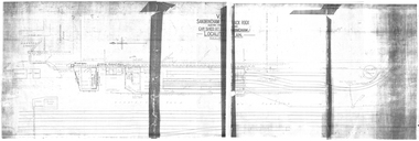
Drawing, VR Sandringham Tram Depot, 1921
... of the Victorian Railways Sandringham Railway station, tram depot, bus... of the Victorian Railways Sandringham Railway station, tram depot, bus ...Set of 8 drawings, prints from original VR drawings of the Victorian Railways Sandringham Railway station, tram depot, bus depot and alterations between 1921 and 1958.\ .1 - VR Sandringham to Black Rock, Electric Street Railway – Car shed at Sandringham – Locality Plan – shows car depot layout, substation, track location for both the railway and tramway, including the platform, goods shed and coal stage. Not dated. Consists of two sheets of paper joined in the middle – 420H x 1210W. Minor creases at end of rolled sheet. .2 - Drawing 1907.21 - Sandringham car shed proposed extension – with note “Not carried out” – dated 2-8-21 Second copy has stamp – Drawer 2, Folio 1, plan 2 in bottom left hand corner. 480H x 630W .3 - Sandringham Station – station layout showing proposed extension to passenger platforms for both 7 and 10 car trains, buildings shops as the southern end of the yard, rail and tramway tracks, streets, dated 12.2.1923. Drawing 582.22. 420H x 590W. .4 - Locker Room for Bus Drivers – plan 264-46, dated 2-5-1946, 295H x 420W. .5 - Shower for Bus Drivers, Plan No. 815-50, dated 15/12/1950, 295H x 420W. Has a note on the drawing – “not carried out”. .6 - Tramcar shed – Site Plan – Entrance Gates – shows conversion arrangements of the depot from trams to buses, including entrance way gates. Plan 456-56. 295H x 420W. .7 - Conversion of sub-station into New Amenities Block - plan number 51-57, dated 22.2.1957 - Detail architectural drawings for the above work. 295H x 420W .8 - Conversion of sub-station into New Amenities Block - plan number 51-57, dated 22.2.1957 - Detail architectural drawings for the above work. 295H x 420W. .9 - Proposed Improvements to Bus Depot - Plan No. 455-52 - not dated. 420H x 595Wtrams, tramways, vr, sandringham, tramways, buses, railways, black rock -
 Melton City Libraries
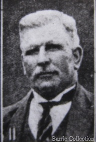
Photograph, Charles Ernest Barrie, Unknown
... for a siding was constructed to the Melton Railway Station. In 1911... was constructed to the Melton Railway Station. In 1911 the Mill’s ...This document is has been compiled by Wendy Barrie daughter of Ernest (Bon) and Edna Barrie and granddaughter of Charles E and Jessie M Barrie. Ernie Barrie operated a travelling Chaff Cutter in the St Arnaud area where his parents William and Mary Ann had taken up land at Coonooer West in 1873. Ernie commenced his working life with a team of bullocks and a chaff cutter. The earliest connection he had with Melton was in 1887. By the beginning of the 20th century Ernie and his father William and brothers, William, Samuel, James Edwin,[Ted] Robert, Arthur and Albert have been associated with farming and milling in the Melton district. In the early 1900’s Ernie and his brother Ted were in partnership in a Chaff cutting and Hay processing Mill on the corner of Station and Brooklyn road Melton South. The mill was managed by William for a time. By 1906 Charles Ernest and James Edwin were in partnership in the Station Road mill when a connecting rail line across Brooklyn Road for a siding was constructed to the Melton Railway Station. In 1911 the Mill’s letterhead shows C.E. BARRIE Hay Pressing and Chaff Cutting Mills. Melton Railway Station. Telephone No 1 Melton. This Mill as sold to H S K Ward in 1916 and stood until 1977 when it burnt down in a spectacular fire. Ernie built a house at Melton South beside the Chaff Mill at Station Road in 1906 and married Jessie May Lang in August at the Methodist Church. Jessie’s father was Thomas Lang. He came to Melton in 1896 and was the Head Teacher at Melton State School No 430 until he retired in 1917. They had 9 children with 8 surviving to adulthood. Jessie and Ernie had 6 sons and 3 daughters. All the children lived at Darlingsford. In April 1910 the family left Melton for a brief period and moved to a farm in Trundle in NSW. They returned to Melton and purchased Darlingsford in May 1911. For a time during WW1 they lived at Moonee Ponds near the Lang grandparents at Ascot Vale. Mary and Bon attended Bank St State School. The children developed diphtheria in 1916 and their youngest boy, Cecil died of complications. Mary and Bon were taken to Fairfield Hospital and both recovered. At the end of the war influenza broke out the family returned to Darlingsford and shared the home for a short while with the Pearcey family who had been working the farm. By 1922 the family had and grown and Edgar, Tom, Horace, Jessie, Joyce and Jim were living a Darlingsford. Ernie continued during the 1920’s working the farm and attend his many civic and community commitments. Two 8 clydesdale horse teams were used to work the land which meant early rising for the horses to be fed and harnessed to commence the days work. In 1916 Ernie also became involved in a Chaff Mill on the corner of Sunshine and Geelong Road West Footscray, which at the time was being run by John Ralph Schutt. It was known an Schutt Barrie. A flour mill was added at a later stage. Other Schutt and Barrie mills were situated at Parwan and Diggers Rest. Another mill was situated beside the railway line at Rockbank. The Footscray mill ceased operation in 1968 Ernie spent a lot of time and energy at the Parwan Mill and travelling around Parwan and Balliang farms, where he came to know many of the families in the district. Ernies commitment to the civic development to the Melton and district was extensive, he was involved with a number of large events during the 1920’s such as the Melton Exhibitions and the 1929 Back to Melton Celebrations. He was a member of the Australian Natives Association at the turn of the century. He was Chairman of the School Committee at Melton State School 430 and the Melton South State School in thw1920s. He donated the land for a Hall for Melton South in 1909, known as Exford Hall and later in 1919 renamed Victoria Hall. The Hall was demolished in 1992. He was a Councillor, JP, and Vice President and President of the Melton Mechanics Institute Hall Committee in 1915- 1916. He was a member of the Methodist Church and later the Scots Presbyterian Church. He was Superintendent of the Sunday School of the Methodist Church to 1910 and later Scots Presbyterian Church until 1931. This is reflected in the theme of children in the stained glass window which was dedicated in his memory by his wife Jessie as a gift to the Scots Church. Charles Ernest Barrie made many generous donations to many charities who supported young people and children. In 1918 Jessie and Ernie made the first donation to a very prominent Victorian charity whose work still continues. Yooralla. In July 1931 Ernie’s untimely death was a major blow to the family and the Melton community. To this day people still vividly recall the day they lined the streets for his funeral. The day of the funeral is recalled as the day Melton stood as two of their prominent citizens who tragically died on the same dayPhotograph of Charles Ernest Barrie taken from Scenes at Melton and Old Residentslocal identities -
 Eltham District Historical Society Inc
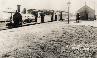
Photograph, Eltham Railway Station, c.1904
... Eltham Railway Station...eltham railway station... at Eltham Railway Station, c.1904 Intending passengers were able... at Eltham Railway Station, c.1904 Intending passengers were able ...A Victorian F-class steam locomotive and passenger train at Eltham Railway Station, c.1904 Intending passengers were able to walk down from the Main Road straight onto the railway platform as the station initially only had tracks on the far side. The rail yard and storage shed for heavy goods is across the tracks. The platform shed-like building is best seen in the 1910 and 1912 photographs. The Victorian Railways F class locomotives were built in 1874 (the pattern engine), 1876–77 and 1879–80 by Beyer, Peacock & Company and the Phoenix Foundry in Ballarat as 2-4-0 tender locomotives. They were normally used on passenger trains. In 1911 the Victorian Railways decided to convert seven of them into "motor" locomotives. These became 2-4-2 tanks. They kept their numbers 172–184 (evens only). The unrebuilt tender engines were taken off register between 1916 and 1922. The "motors" were taken off register between 1920 and 1929. Photographer: J.H. Clark John Henry Clark was the youngest of three boys born to William Henry Clark (1823-1877) and Maria White (1843-1914). He and his brothers, William Charles Clark (1872-1945), Clement Kent Clark (1874-1912) operated a photography business (Clark Bros.) from 25 Thomas Street, Windsor near Prahran during the period c.1894 to 1914. Following death of Clement in September 1912 and their mother in 1914, the Clark Bros business appears to have dissolved, the premises demolished, and a new house was under construction in 1915. John set up business independently in 1914 operating out of 29 Moor Street, Fitzroy where he is registered in the 1914 and 1915 Electoral Rolls. By 1916 John had relocated to Eltham where he continued his practice as a photographer and took many of the early images around the district of Little Eltham. Around 1930 John changed professions and opened a small cobbler's shop in 1931 near the pond opposite Dalton Street adjacent to the Jarrold family cottage. He never married and continued his profession as a bootmaker from this little shop, maintaining a close relationship with Mrs Jarrold for the rest of their lives. His bootmaker shop remains today beside the Whitecloud cottage and is one of only three remaining shops in the area from the early 20th century. There are a couple of images of Eltham taken by Clark Bros. in the Eltham District Historical Society collection, one such example being Hunniford’s Post Office with Miss Anne Hunniford out front (EDHS_00140 - marked on the back of the print, Clark Bros., 25 Thomas St. Windsor), which would date this image between c.1894 and 1914. Other early images of Eltham taken by John Henry Clark are marked on the face “J. H. Clark Photo” and it is assumed these are dated between 1914 and 1930. It is noted that the Grant of Probate for John H Clark of Eltham South dated 5 April !957 (513/387) records his occupation as "X Photographer".Reproduction print of a Clark Photo postcardeltham railway station, postcards, steam train, j.h. clark photo, f-class 2-4-0 steam locomotive, victorian railways, tait train -
 Melbourne Tram Museum
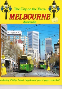
Book, Colour Tech Productions, "The City on the Yarra Melbourne Australia", 1985
... railway yard, Flinders St Station, Westgate bridge, the Trams... railway yard, Flinders St Station, Westgate bridge, the Trams ...Full colour, 28 page on gloss paper travel souvenir guide photos, with a fold out centre fold - titled "The City on the Yarra Melbourne Australia". Features many photographs of the City of Melbourne, Phillip Island, Puffing Billy, Flinders St railway yard, Flinders St Station, Westgate bridge, the Trams of Melbourne, including some Transport Art trams. Trams: 181, 32, 497, 235, 85, 9W, 902, 22, 994, 168, 101, 225, 990 and 861?Has a price lable of $3.50 on the front cover.trams, tramways, transporting art, decorated trams, city of melbourne, travel books, souvenirs -
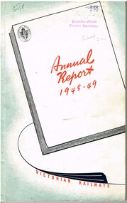 Melbourne Tram Museum
Document - Report, Victorian Railways, "Annual Report 1948-49 - Victorian Railways", 1949
... the results of the Victorian Railways operations for each station... Trams tramways Victorian Railways VR St Kilda Brighton Tramways ...Report - foolscap size, 100 pages, bound with staples along left hand edge and glued into a printed colour cover titled "Annual Report 1948-49 - Victorian Railways". Details the results of the Victorian Railways operations for each station, division, traffic and written information including an investigation by Mr John Elliot of the Southern Region of British Railways into the organisation of Transport in Victoria. Has the results for the two tramways operated by the VR of Appendix 7 (page 55) and the last page of the report.On cover stamped "Australian Electric Traction Association" and hand written Library numbers and notes.trams, tramways, victorian railways, vr, st kilda brighton, tramways, railways -
 Bendigo Historical Society Inc.
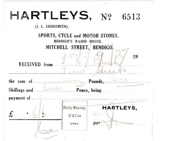
Document - BUSH COLLECTION: BUSINESS ACCOUNTS AND RECEIPTS, 1920 - 1930
... & Jeffrey, Railway Station, Bendigo C. Button, Carrier, 204 William..., Railway Station, Bendigo C. Button, Carrier, 204 William Street ...Collection of approximately 74 accounts, 1925 - 1928, and receipts issued to S. A. Bush from various businesses in Bairnsdale and Bendigo. Invoices from: Hartleys, Mitchell Street, Bendigo. W. Rasmussen, for wood Bendigo Timber Co., Mollison Street and Williamson St. J. Kitchen & Sons Limited, Candle and soap manufacturers Stilwells, House furnishers, William Lunn, Painter, Pall Mall, Bendigo.Hargreaves Street, Bendigo W. McWiliams, wood merchant, 15 Milroy Street, Bendigo. Victorian Railways Commissioners, wood carting H.J. Fraser, A.N.A. building, View Street, Bendigo R.O Henderson, Beehive Pty Ltd., Pall Mall, Bendigo F.C. Cross, Furnishing, Andrew's Building, Hargreaves Street, Bendigo. Albert Bush's Produce Stores, Chaff Mills, Williamson Street, Bendigo. Bendigo Timber Coy. Mollison Street, Bendigo Buckell & Jeffrey, Railway Station, Bendigo C. Button, Carrier, 204 William Street, Bendigo. Furniture packed and stored. (invoice has photo of canvas covered cart. Written on side of cart' Furniture Packed and Stored, The Big Button' . ) W. Irving, House furnishing, 211 Mitchell Street, Bendigo Hartley's Bendigo, Len Shoosmith W. Koska, 297 Williamson Street Albert Bush's Stores, (next St. Paul's Tower) Williamson Street, Bendigo. W.J. Knight, Waggon and Lorry Builder, William Street, Bendigo William Lunn, Bendigo Glass, Pall Mall, Bendigo. Sandhurst and Northern District Trustees, Bendigo Cockings, Drapers, Pall Mall, Bendigo A. Fraser, 178 Carpenter Street, Bendigo W. Irving, furniture store, 211 Mitchell Street, Bendigo Myers, Pall Mall, Bendigo R.C. Eagle, wood merchant, Barnard Street, Bendigo W. McWilliams, wood merchant. W.H Osborn & Co., 130 Williamson Street, Bendigo Campbell & Connelly & Co., High Street, Bendigo H. McWilliams, cartage contractor, 15 Mitchell (?) Street Bendigo. H. Gray, 257 Barnard Street, Bendigo (Singer Sewing Machines) J.D. Allen, 'Whitehall" Sorrento (accommodation 4 weeks) W. McWilliams, for soil and sand.person, individual, bush collection - personal -
 Ballarat Tramway Museum
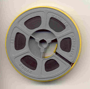
Film - Movie Film & Box, Kodak, 1960s
... outside the Ballarat railway station. 0:12 Image of R class loco... passengers outside the Ballarat railway station. 0:12 Image of R ...Yields information in movie film format of Ballarat trams in 1971 at the time of one of the closure tours and, a enthusiast tour, how the system operated and was used by people., Yields information in movie film format of Ballarat trams in 1971 at the time of one of the closure tours and, a enthusiast tour, how the system operated and was used by people.Movie film - 8mm, approx. 4.14 mins, with white leader strip on a plastic reel, within a Kodak movie yellow plastic container. Has been transferred to DVD - see Reg item 4100 as Segment No. 4. Filmed and made by an unknown person. Synopsis: based on time - Colour film Title "Ballarat trams specials" 0:00 No. 41 and two other bogie trams loading passengers outside the Ballarat railway station. 0:12 Image of R class loco and K class as 2nd loco at the station and train 0:18 Inside a bogie tram looking through saloon door showing the HTT logo. 0:23 From the front of a tram, or 39 turning from Lydiard St Nth into Sturt St and then proceeding along Sturt St. 0:31 Short sequence inside the tram with some passengers in the view 0:39 No. 21, showing Special in Sturt St West and then the two bogie trams following. 1:08 21 turning from Sturt St West into Hamilton Ave, followed by 41, 35 and 37 and then loading photographers. 1:58 As above north of Gardens Loop in Wendouree Parade. 2:07 Interior view of tram moving at speed, then Forest St corner showing church, and Wendouree Parade. 2:24 Drummond St Sth, crossing two trams at Bell St loop 2:29 Sebastopol line, from the window, heading towards the terminus. 2:44 No. 32 at Sebastopol terminus with the pole being turned. 3:01 Single trucker climbing Sturt St hill towards Lydiard St Nth. 3:17 No. 21 turning from Lydiard St Nth into Sturt St 3:31 Bogie tram climbing Sturt St hill towards Lydiard St Nth 3:55 Crossing the railway level crossing in Lydiard St Nth from the window of the tram. 4:02 Train departing from station – very poor sequence – appears to be a K class locomotive. 4:15 end Placed in a blue cardboard box specially made for the item 30/08/2010.trams, tramways, ballarat, vintage train, bell st, level crossings, lydiard st nth, sturt st west, tram 41, tram 39, tram 21, tram 35, tram 37, tram 32 -
 Eltham District Historical Society Inc
Document - Folder, Masefield, Bert and Ethel
... the city to Montmorency when the railway station was first built... the city to Montmorency when the railway station was first built ...Bert Masefield's parents came from Lancashire to Surrey Hills, his education ending because of the depression when he went to work at an orchard at Hastings. When his father list his job as a cabinet maker, he bought an orchard at Cottlesbridge and Bert joined them, ploughing with a horse. He met and married Ethel Smith who had grown u at Panton Hill; her great grandparents Sarah and Samuel Smith came from Lancashire where they had a cotton mill and iron foundry, settling at Smith Gully between Panton Hill and St Andrews. Their son Edwin married Louisa Purcell whose parents owned the Caledonie Hotel at Smiths Gully; they had 12 children and settled on a property in Cherrytree Road. Son Edwin left Panton Hill school aged 11 in 1885 and worked with his father and uncle fencing the family property. Edwin had nine children, Ethel being the seventh. Aged 14, she gained a scholarship to Stotts Business College. Berth and Ethel, when they married, bough a property in Cherrytree Road. In 1941 Bert, a ham radio enthusiast, joined the RAAF as a radio mechanic, serving in Townsville and New Guinea until 1945. Over time, they subdivided their property. Bert worked for ten years as property officer for Eltham Shire Council; his work included coverting Three Chain Road (or Gumtree Road) into a huge firebreak. Now retired, Bert spends time speaking with radio operators around the world and the couple are involved with sports including the Montmorency Bowling Club; they were foundation members of the Hurstbridge Bowling Club. Marjorie North (nee Cooper) was 14 when her family moved from the city to Montmorency when the railway station was first built in 1923. Marjorie described her memories of Montmorency at that time. She and sister Connie were keen tennis players, playing at Greensborough. By 1927, they had arranged, though shire engineer Ben Johnson, to rent land from the Council for 10 pounds a year; Mr Paragreen levelled the land. The club held a dance every three weeks in a school room with piano for music. She won the singles, doubles and mixed doubles championships in 1929 at the first championship. Contents Newspaper article: "Round the world on radio waves," Diamond Valley News, 30 September 1986, outlines Bert and Ethel Masefield's lives. Newspaper article: "Stalwart recalls the early days," Diamond Valley News, 30 September 1986, outlines Bert and Ethel Masefield's lives.Newspaper clippings, A4 photocopies, etcbert masefield, elthel masefield, ethel smith, cherrytree road panton hill, samuel smith, sarah smith, smith gully victoria, caledonie hotel smiths gully, stotts business college, montmorency bowling club, hurstbridge bowling club, eltham shire council, edwin smith, louisa purcell, parragreen of para road, ben johnson, montmorency tennis club -
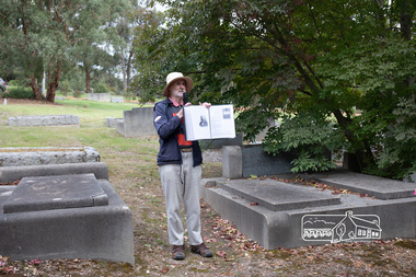
 Eltham District Historical Society Inc
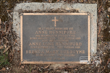
Photograph, Peter Pidgeon, Grave of Anne Hunniford (nee Hamilton Burgoyne) and Anne Jane Hunniford, Eltham Cemetery, Victoria, 5 April 2021
... office was opened near the entrance to the railway station... office was opened near the entrance to the railway station ...On February 1, 1854, the first Eltham Post Office was established. At that time, the number of permanent residents would have been fairly small, probably less than 200. In 1855 Thomas Hunniford was appointed as Eltham's postmaster (replacing Frederick Falkiner). He operated the post office from his general store in Maria Street (now Main Road) near Bridge Street (originally facing Bridge Street but later altered to face Main Road). His daughter, Miss Anne Hunniford, was a teacher at Eltham Primary School in her early adult years. Sometime between 1864 and 1868 the management of the post office passed from Thomas Hunniford to his daughter, Anne who managed the Eltham Post Office until illness forced her to retire in 1928. A big improvement in communication was provided for Eltham residents when a telegraph office was established at the post office in 1877. During 1923 a manual telephone exchange was provided at Eltham, the first two subscribers being J.J. O’Connor and Eltham Police Station. Anne was succeeded by her nephew Neville Burgoyne whose family were then running the store, which had been rebuilt and modernised in 1926 to accommodate an expanded post and telegraph office. Anne knew everyone and was respected for her kindly actions in her official and private capacities. In her time there was no official letter delivery to houses; residents were expected to collect their mail at the post office. But if an important letter or telegram arrived, Anne would try to find someone willing to deliver it. Jock Read recalled he started his own private "mail run"; he would charge people 1/- per week to take their letters to the post office for mailing and would return with their mail. Anne died in 1928, aged 73. She is buried in Eltham Cemetery with her mother and with a Burgoyne child born much later. Burgoyne's store was further extended in 1940 and still stands though has undergone several modifications and businesses. In 1954 the post office moved to a shop in the main Eltham shopping centre, then in 1958 a purpose-built post office was opened near the entrance to the railway station. In Loving Memory of Anne Hunniford Nee Hamilton Burgoyne Born Ireland 1813 Died Eltham 1899 Also her daughter Anne Jane Hunniford Born Eltham 1855 Died Eltham 1928 Brenda May Burgoyne Born 16. 8. 1956 Died 18. 6. 1958 Rest In PeaceBorn Digitaleltham cemetery, gravestones, anne hunniford (nee hamilton burgoyne), anne jane hunniford, brenda mary burgoyne -
 Eltham District Historical Society Inc
Photograph, Peter Pidgeon, Grave of Charlotte Amelia Taylor, Lillian Jane Taylor and Robert David Taylor, Eltham Cemetery, 5 April 2021
... , thus providing quicker access to the railway station..., thus providing quicker access to the railway station ...Robert David Taylor was a farmer who lived in Eltham all his life and died in 1934 at the age of 76. Mr and Mrs Bowman lived in York Street; Taylor was their neighbour. In 1933 he subdivided his land, the plan showing a proposed Grey Street flanked by residential blocks for sale. Mrs Bowman bought one: her family would be able to walk through it and along Grey Street to Henry Street, thus providing quicker access to the railway station. But Taylor retained ownership of Grey Street itself. He fenced it off at each end and charged the Bowmans with trespass when they used it. The matter went to Court. The ruling was that Mrs Bowman could use Grey Street, as she owned land in it, but her husband could not. (Taylor also accused the Bowmans of having broken the fences, but could not prove it.) Taylor had wanted to subdivide his land in 1914. Plans were submitted to Council and were approved, but the subdivision did not proceed. In 1919, Taylor doctored the plans to make it appear that a totally different subdivisional arrangement had been approved. The Titles Office immediately detected fraud, and the Crown charged Taylor with forgery and counterfeiting. But charges were later dropped (reason not recorded). He was an Eltham Shire Councillor between 1911 and 1920. In 1920, Council charged him with illegally felling 91 eucalyptus trees in Eltham Park (60% of them in a healthy condition), presumably to be sold as firewood. He was imprisoned pending trial. Taylor claimed that he had acquired from another man the right to remove timber and sued the Council for wrongful prosecution. The case eventually went to the State Full Court, with judgement given in favour of Council, on the grounds that any right acquired by Taylor covered only the removal of logs and refuse, not sound green timber. And his position as Councillor precluded him from acquiring the right anyway. Robert David Taylor was also a Trustee of the Wesleyan Church owned land at Lot 20 Henry Street, originally purchased in January 1855 for a chapel and from which David and Catherine Clark first ran their private school, the forerunner of the Eltham Primary School. The land was sold in November 1901 to the Hope of Eltham Tent No. 195 Victoria District Independent Order of Rechabites, for which his brother William John Taylor was a Trustee and became the home of the Eltham Rechabite Hall. In December 1921 it was again sold, this time to the community for use as the Eltham Public Hall, Robert David Taylor being a member of the Committee.Born Digitaleltham cemetery, gravestones, charlotte amelia taylor, eltham district historical society, heritage excursion, lillian jane taylor, richard pinn, robert david taylor -
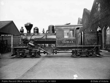 Puffing Billy Railway
Climax - Geared Steam Locomotive No. 1694, 1928
... to the nearest railway station by timber tramway. These tramways were... sawmills to the nearest railway station by timber tramway ...Climax geared locomotive No. 1694 in active service on special occasions - stored at Emerald Station A Miraculous Survivor Climax locomotive No.1694 is a miraculous survivor of a rare breed of steam locomotive. For about 100 years from the mid-1850s sawn timber was carted from Victorian sawmills to the nearest railway station by timber tramway. These tramways were generally very rough, steeply graded, sharply curved, and of narrow gauge. Many had wooden rails, and horses provided haulage. The better ones used steam locomotives. In all about fifty steam locomotives are known to have worked on Victorian timber tramways. These locomotives were usually somewhat peculiar - made to cope with arduous, rough conditions, rather than speed. Climax locomotive No.1694 is the only one of these locomotives to survive intact. It was built in 1928 by the Climax Manufacturing Company, Corry, Pennsylvania, USA, for the Forests Commission of Victoria. The distinctive feature of the Climax locomotive is that the cylinders do not directly connect to the driving wheels. Instead they drive a cross shaft near the centre of the locomotive. From there the drive is transmitted to the small driving wheels through rotating shafts, universal joints, and bevel gears. The driving wheels are mounted in two four-wheel bogies so that they can easily follow sharp curves in the track. None of these features are found in normal steam locomotives. The result is a locomotive that is extremely powerful for its size, and that will cope with sharp curves and steep grades with ease. But this is at the cost of speed, Climax locomotive No.1694 is just about flat-out at 13 km/h (8 mph). Climax Locomotive Built in 1928 for the Forests Commission of Victoria and painted all-over black with the name CLIMAX painted on the sides of the cab in white block letters, this locomotive was issued to the Tyers Valley tramway which branched off the Moe to Walhalla line at Collins Siding. This locomotive was withdrawn from service in 1949 following the closure of the tramway and in 1950 it travelled from Tyers Junction to Collins Siding to Erica where it remained stored until 1965. Loaned to the Puffing Billy Preservation Society for its Steam Museum, it was taken to Menzies Creek in 1965 where it remained until 1982 when the Emerald Tourist Railway Board bought it and transferred it to Belgrave for restoration. It was returned to service for special use on the Belgrave to Gembrook line in 1988 painted in its original all-over black livery, except that the word “Climax” on the sides of the cab was now painted in the style of the Climax Manufacturing Co., a style that this locomotive had never carried.Historical - Industrial railway - Forests Commission of Victoria, Timber Logging Climax Locomotive Climax geared Steam locomotive made of steel and wrought iron Climax 1694climax locomotive works, climax, geared steam locomotive, puffing billy, climax locomotive no. 1694, steam locomotive -
 Melton City Libraries
Photograph, Charles Ernest Barrie and family, 1906
... Railway Station. In 1911 the Mill’s letterhead shows C.E. BARRIE... was constructed to the Melton Railway Station. In 1911 the Mill’s ...Photograph was taken on the 23rd of August 1906, the day of Jessie May Lang and Charles Ernest Barrie's wedding. Held at the Methodist Church Melton. UMMARY – Charles Ernest Barrie d.1931 Born 1871 Ballarat d 1931 This document is has been compiled by Wendy Barrie daughter of Ernest (Bon) and Edna Barrie and granddaughter of Charles E and Jessie M Barrie. My grandfather was well known in the district and was mostly referred to as Ernie. He shared the same initials as his second son Edgar. His three eldest sons lived and farmed in Melton for their entire lives. His descendants are still associated with farming, engineering and earthmoving in Melton. Ernie Barrie operated a travelling Chaff Cutter in the St Arnaud area where his parents William and Mary Ann had taken up land at Coonooer West in 1873. Ernie commenced his working life with a team of bullocks and a chaff cutter. The earliest connection he had with Melton was in 1887. By the beginning of the 20th century Ernie and his father William and brothers, William, Samuel, James Edwin,[Ted] Robert, Arthur and Albert have been associated with farming and milling in the Melton district. In the early 1900’s Ernie and his brother Ted were in partnership in a Chaff cutting and Hay processing Mill on the corner of Station and Brooklyn road Melton South. The mill was managed by William for a time. By 1906 Charles Ernest and James Edwin were in partnership in the Station Road mill when a connecting rail line across Brooklyn Road for a siding was constructed to the Melton Railway Station. In 1911 the Mill’s letterhead shows C.E. BARRIE Hay Pressing and Chaff Cutting Mills. Melton Railway Station. Telephone No 1 Melton. This Mill as sold to H S K Ward in 1916 and stood until 1977 when it burnt down in a spectacular fire. Ernie built a house at Melton South beside the Chaff Mill at Station Road in 1906 and married Jessie May Lang in August at the Methodist Church. Jessie’s father was Thomas Lang. He came to Melton in 1896 and was the Head Teacher at Melton State School No 430 until he retired in 1917. They had 9 children with 8 surviving to adulthood. Jessie and Ernie had 6 sons and 3 daughters. All the children lived at Darlingsford. In April 1910 the family left Melton for a brief period and moved to a farm in Trundle in NSW. They returned to Melton and purchased Darlingsford in May 1911. For a time during WW1 they lived at Moonee Ponds near the Lang grandparents at Ascot Vale. Mary and Bon attended Bank St State School. The children developed diphtheria in 1916 and their youngest boy, Cecil died of complications. Mary and Bon were taken to Fairfield Hospital and both recovered. At the end of the war influenza broke out the family returned to Darlingsford and shared the home for a short while with the Pearcey family who had been working the farm. By 1922 the family had and grown and Edgar, Tom, Horace, Jessie, Joyce and Jim were living a Darlingsford. Ernie continued during the 1920’s working the farm and attend his many civic and community commitments. Two 8 clydesdale horse teams were used to work the land which meant early rising for the horses to be fed and harnessed to commence the days work. In 1916 Ernie also became involved in a Chaff Mill on the corner of Sunshine and Geelong Road West Footscray, which at the time was being run by John Ralph Schutt. It was known an Schutt Barrie. A flour mill was added at a later stage. Other Schutt and Barrie mills were situated at Parwan and Diggers Rest. Another mill was situated beside the railway line at Rockbank. The Footscray mill ceased operation in 1968. Ernie spent a lot of time and energy at the Parwan Mill and travelling around Parwan and Balliang farms, where he came to know many of the families in the district. Ernies commitment to the civic development to the Melton and district was extensive, he was involved with a number of large events during the 1920’s such as the Melton Exhibitions and the 1929 Back to Melton Celebrations. He was a member of the Australian Natives Association at the turn of the century. He was Chairman of the School Committee at Melton State School 430 and the Melton South State School in thw1920s. He donated the land for a Hall for Melton South in 1909, known as Exford Hall and later in 1919 renamed Victoria Hall. The Hall was demolished in 1992. He was a Councillor, JP, and Vice President and President of the Melton Mechanics Institute Hall Committee in 1915- 1916. He was a member of the Methodist Church and later the Scots Presbyterian Church. He was Superintendent of the Sunday School of the Methodist Church to 1910 and later Scots Presbyterian Church until 1931. This is reflected in the theme of children in the stained glass window which was dedicated in his memory by his wife Jessie as a gift to the Scots Church. Charles Ernest Barrie made many generous donations to many charities who supported young people and children. In 1918 Jessie and Ernie made the first donation to a very prominent Victorian charity whose work still continues. Yooralla. In July 1931 Ernie’s untimely death was a major blow to the family and the Melton community. To this day people still vividly recall the day they lined the streets for his funeral. The day of the funeral is recalled as the day Melton stood as two of their prominent citizens who tragically died on the same day. Charles Ernest Barrie with his parents and brothers at the front of the mill house in Melton Southlocal identities -
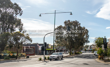 Eltham District Historical Society Inc
Photograph, Peter Pidgeon, Main Road, Eltham, 2 Aug. 2022
... Comparison photo: SEPP_0610 - Main Road near Railway... melbourne Comparison photo: SEPP_0610 - Main Road near Railway ...Comparison photo: SEPP_0610 - Main Road near Railway Station, c.1911 Shows Luther and Ada Haley’s General Store, Bakery and Tea Rooms opened September 1902 directly opposite present day Arthur Street. This was the first building in what is now Eltham’s present shopping town centre. Haley previously ran the General Store and Bakery on the corner of Main Road and York Street until his lease expired and the premises were bought by Mrs Sarah Burgoyne in 1902. Haley sold the store to Hannah Lloyd in 1917 who operated it until 1920. It then went through a succession of owners until Eric Staff purchased it in 1939. Ray Staff succeeded his father in 1954 and eventually demolished the store in 1965 opening up a new supermarket, the Eltham Big Star Food Centre. That building still stands at 929 Main Road and is the Nongkhai Thai Restaurant. On the eastern (right) side of Main Street is Haley’s Paddock, which was used on occasions for community picnics. Capable of holding 10,000 people, with ample shade and hilly surroundings it was an ideal place for any community gathering such as the State Schools’ Picnic in 1904. It was not until the early 1920s that stores started to appear between Luck and Dudley Streets. Part of a presentation by Peter Pidgeon to the Society, 13 August 2022 showcasing a series of photographs taken by John Henry Clark over the period 1895 to 1930. John Henry Clark was the youngest of three boys born to William Henry Clark (1823-1877) and Maria White (1843-1914). He and his brothers, William Charles Clark (1872-1945), Clement Kent Clark (1874-1912) operated a photography business (Clark Bros.) from 25 Thomas Street, Windsor near Prahran during the period c.1894 to 1914. Following death of Clement in September 1912 and their mother in 1914, the Clark Bros business appears to have dissolved, the premises demolished, and a new house was under construction in 1915. John set up business independently in 1914 operating out of 29 Moor Street, Fitzroy where he is registered in the 1914 and 1915 Electoral Rolls. By 1916 John had relocated to Eltham where he continued his practice as a photographer and took many of the early images around the district of Little Eltham. Around 1930 John changed professions and opened a small cobbler's shop in 1931 near the pond opposite Dalton Street adjacent to the Jarrold family cottage. He never married and continued his profession as a bootmaker from this little shop, maintaining a close relationship with Mrs Jarrold for the rest of their lives. His bootmaker shop remains today beside the Whitecloud cottage and is one of only three remaining shops in the area from the early 20th century.Comparative photo taken 2022 with one taken from same location over 100 years earlier by noted local photographer J.H. ClarkBorn Digitaleltham, j.h. clark photo (2022), main road -
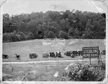 Eltham District Historical Society Inc
Negative - Photograph, Cricket match, Central Park, Eltham, c.1931
... -acquired park near the railway station, and from every point...-acquired park near the railway station, and from every point ...The new Central Park was opened on Monday, 21 April 1930 by Mr. W.H. Everard, M.L.A. followed by a sports carnival. The Advertiser reported on Friday, April 25, 1930 that – “Perfect weather prevailed on Monday for the sports gathering in aid of the recently-acquired park near the railway station, and from every point of view the day was a success. The Central Park contains 9½ acres, and has the Diamond Creek on one side and the railway line on the other. It cost £760, of which the council contributed £500, and the citizens, are finding the balance. Already about £80 has been spent in levelling, and a pavilion has been erected by the footballers, who will use the ground for training until it is sufficiently, improved for matches. There is ample shade along the banks of the creek, where there were numerous picnic parties. The committee has already done some planting on the railway side of the park, and where the trees grow on the higher side, overlooking the arena, the natural stand will have shade, command a view of the events, and have the trees on the banks of the creek in the distance. There were between 600 and 700 people present, many in motor cars having a little difficulty in, finding their way under the aqueduct to the ground, but the council is at present effecting improvements to the road. A merry-go round was a source of pleasure to the children, and the Northcote Soldiers and Citizens Band under Bandmaster Gore, de-lighted everyone with their varied selections of good music.” “Cr. E. J. Andrew, president of the Park Committee, said it was the first function held in the park, and although the citizens have guaranteed £420 towards it, there is still some-thing owing. Mr. W. H. Everard, M.L.A., who can always be relied upon to attend any gathering which draws the people together, said that he and Mrs. Everard had great pleasure in being present to declare the park open. He congratulated the Eltham people upon their public spirit, and the new park would be more appreciated in years to come. The other park is a splendid one, but it is far away, and one is required close to the station, so that young people can have a day's enjoyment, without having to go far from the station. The trouble in Victoria is not having enough parks. The early settlers did a lot in getting park lands, but the present generation is not doing enough. Eltham people are entitled to the highest commendation for their action, and Cr. Andrew and the council are to be thanked for what they have done. What is wanted is ingress and egress so that people can get in comfortably. When he was motoring in his wife said, "Surely you are not going down that precipice," and he replied that he would go anywhere where the people were. In the future it will be the big centre of Eltham.” Reproduced on page 96 of 'Pioneers & Painters'This photo forms part of a collection of photographs gathered by the Shire of Eltham for their centenary project book,"Pioneers and Painters: 100 years of the Shire of Eltham" by Alan Marshall (1971). The collection of over 500 images is held in partnership between Eltham District Historical Society and Yarra Plenty Regional Library (Eltham Library) and is now formally known as the 'The Shire of Eltham Pioneers Photograph Collection.' It is significant in being the first community sourced collection representing the places and people of the Shire's first one hundred years.Digital image 4 x 5 inch B&W Neg 9 x12.5 cm printsepp, shire of eltham pioneers photograph collection, eltham, eltham central park, automobile, central park, cricket match, pioneers and painters -
 Melton City Libraries
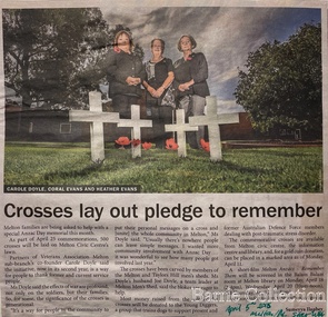
Newspaper, Crosses lay out pledge to remember, 2015
... the packages to the Melton railway station, until he enlisted... the packages to the Melton railway station, until he enlisted ..."The outbreak of World War I in August 1914 had an immediate impact on communities across Australia, and it was no different in Melton. Young men began enlisting immediately, and Australia’s initial offer of 20,000 troops was soon exceeded by Victorian enlistments alone. Over the four years of the war, approximately 114,000 Victorians enlisted and around 91,000 servicemen and women were sent overseas. They came not just from Melbourne, but from all over the state; from farms, small towns and suburban areas. They included locals, newly arrived migrants and Indigenous people. The Australian home front was a hive of activity throughout the war, and the Melton community played its part. Following the announcement that Australia was joining the war with Great Britain and its allies on 5 August 1914, the Melton community lost no time in launching into action. A meeting ‘to assist the Red Cross fund’ was held in the Melton Mechanics’ Institute hall on 18 August – just days after the outbreak of the war. Collectors were appointed for each corner of the shire and individual donations were made. A Melton branch of the Australian Red Cross Society was formed in June 1915 and focused its energies on raising funds to purchase material that was used to make clothes for sick and wounded soldiers. A depot was established in Melton to collect clothing and other ‘comfort’ items for the soldiers – including reading material, tobacco, linen, canned foods and soap – and to coordinate the branch’s work and activities. Local cab driver Percival Stubbs volunteered to transport all the packages to the Melton railway station, until he enlisted and departed for the front in 1916. Such were the numbers of people getting involved that branches were also established in Toolern Vale and Rockbank. Regular community events were held to farewell soldiers who were leaving on active service and to welcome those who returned home. Gunner Robert (Bob) Wynne, whose uncle’s family ran the general store in Toolern Vale, was presented with a pair of field glasses (binoculars), a gold watch, inscribed locket and autographed letter by the Toolern Vale community before he set sail for the front in 1916. His mother noted that he ‘sailed away in good spirits with a smile till out of sight’. From June 1915 to June 1919, the Melton Red Cross branch donated 2,156 pairs of socks, 1,357 shirts, 425 kit bags, 251 pillowslips, 224 towels and 121 pairs of pajamas. Countless fundraising events were held, including jumble fairs, concerts and gift evenings. Local schools also encouraged students to contribute through fund-raising and making and collecting comforts for the soldiers. People across the country engaged in similar activities, but Victoria’s rural communities found unique ways of contributing. In Melton, people were encouraged to send rabbits and hares ‘in good condition’ to an exporter in Spencer Street, for export to Belgium ‘for the relief of those suffering". Special Anzac Memorial article featured in the Star Weeklylocal identities, war -
 Puffing Billy Railway
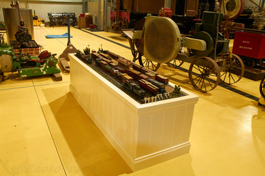
Victorian Railways Broad Gauge model railway, 1930 to 1970
... Model of Victorian Railways Broad Gauge - Dalhouse Station...Puffing Billy Railway 1 old monbulk road Belgrave yarra ...Model of Victorian Railways Broad Gauge - Dalhouse Station The Models were hand made including electric motors and cast metal by Desmond Henry Ramsay over 40 years - from the age of 15 ( 1930 ) until his death in 1970. The locomotives and carriages are all replicas of Victorian Railways Broad Gauge. The Dalhouse Station and station yard were inspired by victorian railways design. This Model of Victorian Railways Broad Gauge was kindly donated to the Puffing Billy Railway Museum by the family of Desmond Henry Ramsay - Elwyn Stankiewicz - Vanessa Bourke - Roger Ward. (plaque afixed on case)Historic - Hand made Model of Victorian Railways Broad Gauge by Desmond Henry RamsayModels of Victorian Railways Broad Gauge rolling stock - Hand Made - plastic and cast metal puffing billy, victorian railways, model railway, o scale, desmond henry ramsay -
 Bendigo Historical Society Inc.
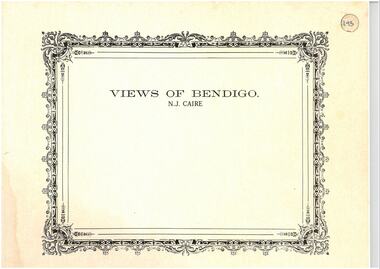
Photograph - VIEWS OF BENDIGO: COPIES OF 52 PHOTOS, 1850 - 1900
... 2 No 28 Long Gully. No 29 Railway station and sheds No 30... Railway station and sheds No 30 Cemetery Back Ck. No 31 Kock's ...Copies of Photographs from - Views of Bendigo by Nicholas Caire Originals in Box 13 No.1 Sandhurst east/ City Reserve x 2 No 2 New Chum Line of Reef No 3 Sandhurst to North from top of Masonic Hall No.4 Hustler's Line of Reef No.5 Battery of stampers for crushing quartz x 2 No.6 View Sandhurst from top of Masonic Hall x 2 No.7 Excavation Quartz Reef, Ironbark Hill. No 8 St. Paul's Church. No.9 View Camp Reserve from Court House. No.10 View of Nth. Old Chum. No.11 View Camp Hill near the Lodge x 2 No.12 Garden Gully. No.13 Shamrock Hotel, Sandhurst. No.14 View from Court House, east end Pall Mall. No.15 Wesleyan Church, Golden Square x 2 No.16 Savings Bank, Sandhurst No.17 Bendigo District Hospital. No.18 Interior Wesleyan Church x 2 No.19 View Golden Square township. No.20 The Town Hall, Sandhurst. No 21 The City Hotel,Sandhurst. No 22 Pall Mall Sandhurst, No 23 Sandhurst City Market No 24 Pall Mall looking west x 2 No 25 Camp Hill x 2 No 26 Charing Cross No 27 View Sandhurst. x 2 No 28 Long Gully. No 29 Railway station and sheds No 30 Cemetery Back Ck. No 31 Kock's Pioneer Quartz Crushing Plant Long Gully. No 32 Masonic Hall. No 33 Bendigo Benevolent Asylum. No 34 Bendigo Flat. No 35 Old Chum Hill x 2 No 36 New Chum Gully No 37 Township of Eaglehawk No 38 From St Paul's tower looking west No 39 Tunnel Big Hill. No 40 From St Paul's tower looking south x 2 No 41 From St Paul's tower looking eastward x 2 No 42 From St Paul's tower looking north west x 2 No 43 Great Extended Hustlers Quartz Mining Claim No 44 Big Hill Rail line x 2 No 45 From St Paul's tower looking westward x 2 No 46 From St Paul's tower looking north west No 47 Big Hill Ranges Buick. x 2 No 48 St.Paul's Tower x 2 No 49 Eaglehawk township. No 50 Mitchell Street No 51 Botanical gardens, White Hills x 2 No 52 View Point, Sandhurst. .N.J. Caire.place, bendigo, bendigo area., views of bendigo. -
 Ringwood and District Historical Society
Pamphlet, G.A. Green, Auction Sale Brochure - Garden Farms Estate, Ringwood, Victoria - 1919, 1919
... railways junction here. The passengers from Ringwood Station... railways junction here. The passengers from Ringwood Station ...Multi-fold brochure advertising public auction of one-acre, 2-acre, 5-acre and 8-acre allotments in Ringwood and Bayswater on Saturday 12th April, 1919. Brochure includes terms of sale, description of subdivision features and local facilities, and photographic images of the area.Subdivison includes Canterbury Road Heathmont, Armstrong Road Heathmont, Armstrong Road Bayswater, Bungalook Road Heathmont, Bungalook Road Bayswater, and Orchard Road Bayswater. Road shown as Bayswater Road to Bayswater became Mountain Highway Bayswater. Vendor: H.E.B.Armstrong, Auctioneers: Coghill & Haughton, 79 Swanston Street Melbourne, Telephone Central 2793, in conjunction with J.B. McAlpin, Ringwood, Opposite Station, Telephone Ringwood 7. (Map) Woodcock & McCormack, Civil Engineers Architects & Surveyors, 430 Little Collins Street, Melbourne, Phone 3241 Central. MOST OF THE MONEY COMES OUT OF THE LAND. And more money can be obtained from anb acre of fruit than from an acre of any other produce. But you do not have to grow fruit on Garden Farms Estate. You can go in for - Outer Suburban Home - Market Garden - Orchard - Pig Raising - Poultry Farm - Small Dairy Farm - Small Fruits - Floral Culture - Scent and Bee Farm - Or just for a Week-end Home. RINGWOOD - THE PLACE TO LIVE. The Beautiful Ringwood District has so many natural attractions, that half a Land Agent's work is done in just showing a prospective buyer round and about. Ringwood has a pull of its own that attracts folk, proved beyond doubt by its rapid development within the last decade (spite the war). First, it is high and healthy, picturesque and undulating, convenient of access, sufficiently close to the Metropolis for City and Business folk to live at Ringwood. Its development is solid, because most of its people are industrious husbandmen, real producers, who have turned idle hills into smiling gardens. These are the kind of real people to live amongst; ones who wear out their spades. The rapidly-developing town has excellent Stores, Trade and Repair Shops Churches, Banks, Telephone Exchange, Weekly General Market, Cool Stores, and good Private and State Schools, etc.; is Electrically lit, has Metropolitan Water Supply, and generally provides so that practically all shopping can be done locally. WHY RINGWOOD MUST GROW. Ringwood is a great centre and must be a greater. Two rapidly-developing railways junction here. The passengers from Ringwood Station cityward, in one year, number 250,000. Ringwood will be the terminus of the Outer Suburban Electric Eastern Railway. Its natural boundaries are the River Yarra on the North, Dandenong Creek on the South, the popular town of Croydon on the East, and the suburb of Mitcham on the West. This is a large territory that is steadily being converted from intense culture, and then it might be called (as regards its gardens) "The Devon Territory of Victoria." ARMSTRONG ROAD. This new road traverses Garden Farms Estate from its northern boundary on the main Canterbury Road, across Dandenong Creek, to its southern boundary on the main Bayswater Road, and will provide a long-desired additional link of communication between Bayswater and Ringwood. The 1-acre building sites on Bayswater Road are within 8 minutes' walk of the Bayswater Railway Station, and the Canterbury Road frontages are only 1-1/2 miles from Ringwood Station, and 1/2 mile from the Railway Station site of Canterbury Road; therefore, the whole Estate is easy of access and there should be a large demand for land so favourably placed. (Image) Cultivation Field - Potatoes on Lot 28 (Image) Picture of Bayswater Creek Flats. (Image) View from "Korumbeen" where Mr. Armstrong lived on Garden Farms Estate. Estate outlined in white ring. (Image) Site of New Bridge over Dandenong Creek. (Image) On one of the timbered lots adjoining railway. (Image) This Dandenong Creek traveres the Estate. (Image) Main Fern Tree Gully Line bisects the Estate. -
Bendigo Historical Society Inc.
Newspaper - PETER ELLIS COLLECTION: RECOLLECTIONS PICTORIAL LIFTOUT
... Bridge. 2 Original railway station viewed from Mitchell st bridge... down Mitchell st from Railway Bridge. 2 Original railway ...Historical liftout. Newspaper. Titled RECOLLECTIONS Pictorial Liftout 1990.1 looking down Mitchell st from Railway Bridge. 2 Original railway station viewed from Mitchell st bridge. 3 The great extended Hustlers mine. 4 1873 photo recently extended town hall with corn exchange at front left. 5 looking north westerly from city rec reserve at royal hustlers. 6 children play on mullock heap in front of a view of westerly quarter of Sandhurst. 7 Bank of Victoria, Mitchell st left is Bendigo's original post office. 8 Looking down from what is now Rosalind Park. Shamrock Hotel can be seen on corner of Williamson st and Pall Mall. This photo predates the construction of post office and law courts. 9 girl eating fairy floss. 10 4 kids on 1 horse in procession. 11 monkey and pedal car, a novelty attraction 1940's. 12 pony rides. 13 flying horses (ride). 14 procession past city hall. 15 Original ANZ bank corner Williamson st & Pall Mall. 16 Chinese Dragons Bendigo Easter Fair 1940's. 17 City Hall viewed from Bull st. 18 City hall original ceiling. 19 new town hall 1861. Mike Butcher, local historian. 21 Interior plan of city hall (groundfloor) 22 circa 1920's 23 Tattered fragment original architect's drawing. 24 original assembly room. 25 Camp Hill PS Shamrock hotel without top storeys. 27 shop with signage advertising Bushells, Bex and Swallow's Biscuits. 28 View from where fountain is now. 29 Hargreaves st looking south, now Hargreaves mall. Horse drawn water tank watering down road. 30 Central Deborah Gold mine poppet head. 31 Borough town hall, tram ways. 32 Original ANZ Bank corner Williamson st and Pall Mall, demolished in mid 1960's. 33 Bush's store corner Williamson and Myer streets.34 Men on boat, don't know what or where. 35 Shearers. 36 man on a three wheeled bike. 37 4 Gold miners with shovels. 38 6pm closing, no trade Sundays, no women in main bar. 39 Peaceful scene Castlemaine 1940's Photographer Alan Doney. 40 Qantas Jet The City of Bendigo Tullamarine Airport. BCV-8 camera man & Advertiser photographer. 41 Ladies. 42 Tennis -> men and women (women in hats). 43 Sandhurst footy team. 44 Early school photo.Alan Doneybendigo, history, photographic history -
 Ballarat Tramway Museum
Slide - 35mm slide/s, Peter Moses, 21/08/1971 12:00:00 AM
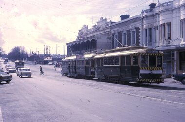
... truck cars in the photo as are the railway gates at the station... truck cars in the photo as are the railway gates at the station ...Photo of SEC Ballarat No. 14 and possibly No. 42 (Briquette roof advertisement and features on the same special trams in Reg. item 2064) waiting in Lydiard St. North for the arrival of the ARHS special on Saturday 21/8/1971 to undertake the last tour of Ballarat Tramways, prior to the closure of the system. The first line closure (Victoria St.) took place the following day. Has Reid's Coffee Palace building in the background and other buildings on the east side of Lydiard St. North. Two other single truck cars in the photo as are the railway gates at the station. Kodak cardboard mount slide, taken by Peter Moses 21 August 1971.On back of slide in light black ink "N14 Ballarat / ARHS / 4 trams special Lydiard St" and "P. Moses" in black ink in the upper right hand side of the slide.tramways, trams, arhs, lydiard st north, railway crossing, tram 14, tram 42 -
 Melbourne Tram Museum
Document - Report, Melbourne & Metropolitan Tramways Board (MMTB), "Melbourne and Metropolitan Tramways Board General Scheme", c1923
... and changes to resolve crossing the Railway at Brighton Station. 2... Parliament Brighton Railways Finances Both documents have been ...Personal Papers titled "Melbourne and Metropolitan Tramways Board General Scheme": File comprises of: 1. Typed document noting the MMTB Minute of the Board meetings of 30/11/1922, 24/5/1923 and 26/7/1923 approving the General Scheme be forwarded to the Minister and the Parliamentary Standing Committee and changes to resolve crossing the Railway at Brighton Station. 2 - Printed document - 1923 - Report - 8 pages - The Parliamentary Standing Committee on Railways - General Scheme for Tramways for Metropolis - printed 24/7/1923. Has stapled to the document a pink cover sheet. Gives details of the committee, the committee report, comments on the Board's financial position, the debate between tramways or railways, recommendations and views of the Railways Commissioners. Attached to the report is the MMTB 30 page duplicated document giving the Board's proposals. See Reg Item 2089 for actual drawings referred to. See Reg Item 2098 and 3374 for another copy of this document and the map.Both documents have been stamped "Perway File"trams, tramways, mmtb, general scheme, tramways, development, parliament, brighton, railways, finances -
 Eltham District Historical Society Inc
Photograph, Upper Yarra Dam, Spring Tour, 22 Oct 1995, 22/10/1995
... the old Railway Station at Launching Place the Centennial Trail... the old Railway Station at Launching Place the Centennial Trail ...EXPLORING THE UPPER YARRA (Newsletter No. 105, November 1995, by Bettina Woodburn) We enjoyed the Spring Excursion, this year "Exploring the Upper Yarra" - in spite of the constant rain and the countryside under the cloud cover, especially in the valleys, being mainly shiny shades of green. The occasional fields of buttercups, clumps of arum lilies and splendid rhododendron and other flowering bushes became very special. The Cobb and Co coach was warm and a cosy retreat as we zig-zagged on the highways and byways to glimpse the Yarra River, upstream and down, its secret places, and particularly the many bridges. Russell excelled as 'Poet Laureate', reading from Dacre Smyth's book. This 1979 publication includes paintings of all the bridges along the river with poems and brief descriptions of each one. Some of the bridges are in out of the way places and are not very well known. We looked forward to hearing the poetry as much as seeing the ' constructions'…Big Pat (was he short or tall, lean or fat? He did win the two hundred pound reward for discovering gold and had the creek named after him), about the 'Eddies'?, and the disliked 'meccano' bridge in Warburton, etc. etc. The hot roast lunch in the old Reefton Hotel was also most welcome. It was easy to imagine it peopled by miners and early settlers. Starting by crossing the new (1974) concrete bridge at Warrandyte we headed through Wonga Park with views to the Christmas Hills and to the escarpment of the Yering Gorge, which causes flood waters to back up through the Yarra Glen plain, so avoiding disasters downstream. At the end of a long driveway we found the wooden, privately owned Henley Bridge (1935 after the 1934 floods). This facilitates access to different parts of Henley Farm and to Lilydale. Everard Park, named after Blanche Shallard's father, a State Member for 17 years, below the Highway Yarra crossing was in need of care. It is 10 miles from Yarra Glen by road but, as "Yarra Marra” canoeists well know, 32 winding miles down by water. After more delightful countryside scenes we joined the Warburton Highway at Woori Yallock. From the old Railway Station at Launching Place the Centennial Trail for walkers, cyclists and ' horse riders has replaced the rails. The line from Lilydale was opened in 1901, and the last diesel freight train ran to Warburton in 1965. It continued to rain as we had morning tea in Warburton in a shelter between footbridges. From here we continued upstream past the Bridge to O'Shannasy Lodge and Reservoir, Starvation Creek, and the Peninsular tunnel (miners dug it as at Pound Bend) which we visited (scrambling down those steps!) on our return after lunch. Our furthermost point was the Upper Yarra Dam Reserve (and vast catchment area). Finished in 1957 after ten years work and 100 years after Yan Yean, it supplies much of Melbourne's water. After crossing the 30m Launching Place Bridge to the Eltham side of the Yarra and Healesville, we saw in the distance the Yarra Glen Timber Trestle Bridge over the river flats "the longest for years in the land it was said!" Harry's dream of "better weather over the Divide" unfortunately didn't come true, but I'm sure we 36 members will retain happy memories of a day that was wet and green and filled with Bridges. Bettina Woodburn - October 1995 Record of the Society's history of activities - Spring 1995 excursionColour photographshire of eltham historical society, activities, upper yarra dam, henley bridge -
 Eltham District Historical Society Inc
Photograph, Upper Yarra Dam, Spring Tour, 22 Oct 1995, 22/10/1995
... the old Railway Station at Launching Place the Centennial Trail... the old Railway Station at Launching Place the Centennial Trail ...EXPLORING THE UPPER YARRA (Newsletter No. 105, November 1995, by Bettina Woodburn) We enjoyed the Spring Excursion, this year "Exploring the Upper Yarra" - in spite of the constant rain and the countryside under the cloud cover, especially in the valleys, being mainly shiny shades of green. The occasional fields of buttercups, clumps of arum lilies and splendid rhododendron and other flowering bushes became very special. The Cobb and Co coach was warm and a cosy retreat as we zig-zagged on the highways and byways to glimpse the Yarra River, upstream and down, its secret places, and particularly the many bridges. Russell excelled as 'Poet Laureate', reading from Dacre Smyth's book. This 1979 publication includes paintings of all the bridges along the river with poems and brief descriptions of each one. Some of the bridges are in out of the way places and are not very well known. We looked forward to hearing the poetry as much as seeing the ' constructions'…Big Pat (was he short or tall, lean or fat? He did win the two hundred pound reward for discovering gold and had the creek named after him), about the 'Eddies'?, and the disliked 'meccano' bridge in Warburton, etc. etc. The hot roast lunch in the old Reefton Hotel was also most welcome. It was easy to imagine it peopled by miners and early settlers. Starting by crossing the new (1974) concrete bridge at Warrandyte we headed through Wonga Park with views to the Christmas Hills and to the escarpment of the Yering Gorge, which causes flood waters to back up through the Yarra Glen plain, so avoiding disasters downstream. At the end of a long driveway we found the wooden, privately owned Henley Bridge (1935 after the 1934 floods). This facilitates access to different parts of Henley Farm and to Lilydale. Everard Park, named after Blanche Shallard's father, a State Member for 17 years, below the Highway Yarra crossing was in need of care. It is 10 miles from Yarra Glen by road but, as "Yarra Marra” canoeists well know, 32 winding miles down by water. After more delightful countryside scenes we joined the Warburton Highway at Woori Yallock. From the old Railway Station at Launching Place the Centennial Trail for walkers, cyclists and ' horse riders has replaced the rails. The line from Lilydale was opened in 1901, and the last diesel freight train ran to Warburton in 1965. It continued to rain as we had morning tea in Warburton in a shelter between footbridges. From here we continued upstream past the Bridge to O'Shannasy Lodge and Reservoir, Starvation Creek, and the Peninsular tunnel (miners dug it as at Pound Bend) which we visited (scrambling down those steps!) on our return after lunch. Our furthermost point was the Upper Yarra Dam Reserve (and vast catchment area). Finished in 1957 after ten years work and 100 years after Yan Yean, it supplies much of Melbourne's water. After crossing the 30m Launching Place Bridge to the Eltham side of the Yarra and Healesville, we saw in the distance the Yarra Glen Timber Trestle Bridge over the river flats "the longest for years in the land it was said!" Harry's dream of "better weather over the Divide" unfortunately didn't come true, but I'm sure we 36 members will retain happy memories of a day that was wet and green and filled with Bridges. Bettina Woodburn - October 1995 Record of the Society's history of activities - Spring 1995 excursionRoll of 35mm colour negative film, 3 stripsKodak Gold 200-4shire of eltham historical society, activities, upper yarra dam, henley bridge -
 Eltham District Historical Society Inc
Photograph, Upper Yarra Dam, Spring Tour, 22 Oct 1995, 22/10/1995
... the old Railway Station at Launching Place the Centennial Trail... the old Railway Station at Launching Place the Centennial Trail ...EXPLORING THE UPPER YARRA (Newsletter No. 105, November 1995, by Bettina Woodburn) We enjoyed the Spring Excursion, this year "Exploring the Upper Yarra" - in spite of the constant rain and the countryside under the cloud cover, especially in the valleys, being mainly shiny shades of green. The occasional fields of buttercups, clumps of arum lilies and splendid rhododendron and other flowering bushes became very special. The Cobb and Co coach was warm and a cosy retreat as we zig-zagged on the highways and byways to glimpse the Yarra River, upstream and down, its secret places, and particularly the many bridges. Russell excelled as 'Poet Laureate', reading from Dacre Smyth's book. This 1979 publication includes paintings of all the bridges along the river with poems and brief descriptions of each one. Some of the bridges are in out of the way places and are not very well known. We looked forward to hearing the poetry as much as seeing the ' constructions'…Big Pat (was he short or tall, lean or fat? He did win the two hundred pound reward for discovering gold and had the creek named after him), about the 'Eddies'?, and the disliked 'meccano' bridge in Warburton, etc. etc. The hot roast lunch in the old Reefton Hotel was also most welcome. It was easy to imagine it peopled by miners and early settlers. Starting by crossing the new (1974) concrete bridge at Warrandyte we headed through Wonga Park with views to the Christmas Hills and to the escarpment of the Yering Gorge, which causes flood waters to back up through the Yarra Glen plain, so avoiding disasters downstream. At the end of a long driveway we found the wooden, privately owned Henley Bridge (1935 after the 1934 floods). This facilitates access to different parts of Henley Farm and to Lilydale. Everard Park, named after Blanche Shallard's father, a State Member for 17 years, below the Highway Yarra crossing was in need of care. It is 10 miles from Yarra Glen by road but, as "Yarra Marra” canoeists well know, 32 winding miles down by water. After more delightful countryside scenes we joined the Warburton Highway at Woori Yallock. From the old Railway Station at Launching Place the Centennial Trail for walkers, cyclists and ' horse riders has replaced the rails. The line from Lilydale was opened in 1901, and the last diesel freight train ran to Warburton in 1965. It continued to rain as we had morning tea in Warburton in a shelter between footbridges. From here we continued upstream past the Bridge to O'Shannasy Lodge and Reservoir, Starvation Creek, and the Peninsular tunnel (miners dug it as at Pound Bend) which we visited (scrambling down those steps!) on our return after lunch. Our furthermost point was the Upper Yarra Dam Reserve (and vast catchment area). Finished in 1957 after ten years work and 100 years after Yan Yean, it supplies much of Melbourne's water. After crossing the 30m Launching Place Bridge to the Eltham side of the Yarra and Healesville, we saw in the distance the Yarra Glen Timber Trestle Bridge over the river flats "the longest for years in the land it was said!" Harry's dream of "better weather over the Divide" unfortunately didn't come true, but I'm sure we 36 members will retain happy memories of a day that was wet and green and filled with Bridges. Bettina Woodburn - October 1995 Record of the Society's history of activities - Spring 1995 excursionRoll of 35mm colour negative film, 2 stripsKodak Gold 100-4shire of eltham historical society, activities, upper yarra dam, henley bridge -
 Eltham District Historical Society Inc
Photograph, Upper Yarra Dam, Spring Tour, 22 Oct 1995, 22/10/1995
... the old Railway Station at Launching Place the Centennial Trail... the old Railway Station at Launching Place the Centennial Trail ...EXPLORING THE UPPER YARRA (Newsletter No. 105, November 1995, by Bettina Woodburn) We enjoyed the Spring Excursion, this year "Exploring the Upper Yarra" - in spite of the constant rain and the countryside under the cloud cover, especially in the valleys, being mainly shiny shades of green. The occasional fields of buttercups, clumps of arum lilies and splendid rhododendron and other flowering bushes became very special. The Cobb and Co coach was warm and a cosy retreat as we zig-zagged on the highways and byways to glimpse the Yarra River, upstream and down, its secret places, and particularly the many bridges. Russell excelled as 'Poet Laureate', reading from Dacre Smyth's book. This 1979 publication includes paintings of all the bridges along the river with poems and brief descriptions of each one. Some of the bridges are in out of the way places and are not very well known. We looked forward to hearing the poetry as much as seeing the ' constructions'…Big Pat (was he short or tall, lean or fat? He did win the two hundred pound reward for discovering gold and had the creek named after him), about the 'Eddies'?, and the disliked 'meccano' bridge in Warburton, etc. etc. The hot roast lunch in the old Reefton Hotel was also most welcome. It was easy to imagine it peopled by miners and early settlers. Starting by crossing the new (1974) concrete bridge at Warrandyte we headed through Wonga Park with views to the Christmas Hills and to the escarpment of the Yering Gorge, which causes flood waters to back up through the Yarra Glen plain, so avoiding disasters downstream. At the end of a long driveway we found the wooden, privately owned Henley Bridge (1935 after the 1934 floods). This facilitates access to different parts of Henley Farm and to Lilydale. Everard Park, named after Blanche Shallard's father, a State Member for 17 years, below the Highway Yarra crossing was in need of care. It is 10 miles from Yarra Glen by road but, as "Yarra Marra” canoeists well know, 32 winding miles down by water. After more delightful countryside scenes we joined the Warburton Highway at Woori Yallock. From the old Railway Station at Launching Place the Centennial Trail for walkers, cyclists and ' horse riders has replaced the rails. The line from Lilydale was opened in 1901, and the last diesel freight train ran to Warburton in 1965. It continued to rain as we had morning tea in Warburton in a shelter between footbridges. From here we continued upstream past the Bridge to O'Shannasy Lodge and Reservoir, Starvation Creek, and the Peninsular tunnel (miners dug it as at Pound Bend) which we visited (scrambling down those steps!) on our return after lunch. Our furthermost point was the Upper Yarra Dam Reserve (and vast catchment area). Finished in 1957 after ten years work and 100 years after Yan Yean, it supplies much of Melbourne's water. After crossing the 30m Launching Place Bridge to the Eltham side of the Yarra and Healesville, we saw in the distance the Yarra Glen Timber Trestle Bridge over the river flats "the longest for years in the land it was said!" Harry's dream of "better weather over the Divide" unfortunately didn't come true, but I'm sure we 36 members will retain happy memories of a day that was wet and green and filled with Bridges. Bettina Woodburn - October 1995 Record of the Society's history of activities - Spring 1995 excursionRoll of 35mm colour negative film, 2 stripsKodak Gold 100-4shire of eltham historical society, activities, upper yarra dam, henley bridge