Showing 4068 items matching " surveys"
-
 Bendigo Military Museum
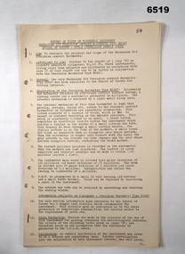
Administrative record - Report on Mechanism Ltd Precision Aneroid Barometer Type M1847 - WO2 Lambert (RASvy) August 1960, WO2 Lambert RASvy, August 1960
This is a Report on the Mechanism Ltd Precision Aneroid Barometer Type M1847 by WO2 Lambert (RASvy) August 1960 under the direction of the Chief Instructor at the School of Military Survey Balcombe Victoria was to determine the accuracy of the instrument for calculating heights for mapping purposes.A 6 x Foolscap sized page report that is stapled and four hole punched.. The report contains typed text, diagrams and tabular results on the fold out annex.Number "54" in top RH cornerroyal australian survey corps, rasvy, fortuna, army survey regiment, army svy regt, asr, school of military survey, balcombe -
 Bendigo Military Museum
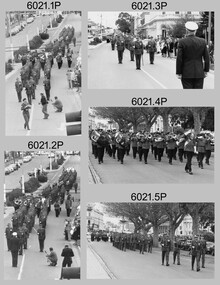
Photograph - Army Survey Regiment Freedom of Entry Parade, 1980
The Freedom of Entry to the City was an honour conferred by the Bendigo City Council to the Army Survey Regiment in 1970. 1980 was the third time the unit exercised its freedom of marching into the city with swords drawn, bayonets fixed and drums beating. The honour is usually bestowed upon local regiments, in recognition of their dedicated service, and it is common for military units to periodically exercise their freedom by arranging a parade through the city. Led by the Regiment’s CO – LTCOL Bob Skitch, the unit marched down View St in the CBD, along Pall Mall and up Gaol Rd to the Queen Elizabeth II Oval. The ceremonial parade followed with a march past the guests of honour, Mayor of Bendigo Councillor Paul Tomkinson and military dignitaries. The parade concluded after formal inspections of the troops. The Regiment also exercised its Freedom of Entry with anniversary parades in 1977, 1980, 1985, 1990 and 1995.These black and white photographs of the Army Survey Regiment were taken on the occasion of the Freedom of Entry parade to the City of Bendigo in 1980. The photographs were printed on photographic paper and are part of the Army Survey Regiment’s Collection. The photographs were scanned at 300 dpi. .1) Photo, black & white, L to R: MAJ Don Swiney, LTCOL Bob Skitch, WO1 Aub Harvey, unidentified, photographer in foreground – SGT Garran Hill .2) Photo, colour, black & white, L to R: MAJ Don Swiney, LTCOL Bob Skitch, WO1 Aub Harvey, unidentified .3) Photo, black & white, L to R: MAJ Don Swiney, WO1 Aub Harvey, LTCOL Bob Skitch, unidentified .4) Photo, black & white: 3rd MD Band .5) Photo, colour, L to R: MAJ Don Swiney, WO1 Aub Harvey, LTCOL Bob Skitch, unidentified .6) Photo, black & white, L to R: MAJ Don Swiney, WO1 Aub Harvey, unidentified, LTCOL Bob Skitch .7) Photo, black & white, L to R: SGT Stu Thaxter, LT Neil Taylor, CAPT Bob Roche .8) Photo, black & white, L to R: SPR Per Andersen – right marker .9) Photo, black & white, L to R: MAJ Peter Eddy .10) Photo, black & white, L to R: CPL Frank Lenane, CPL Flash Anderson, SGT Rhys De Laine, SPR Per Andersen .11) Photo, black & white, L to R: Mayor Paul Tomkinson .12) Photo, black & white, L to R: MAJ Don Swiney, WO1 Aub Harvey, unidentified, LTCOL Bob Skitch .13) Photo, black & white, L to R: unidentified personnel .14) Photo, black & white, L to R: unidentified personnel .15) Photo, black & white, L to R: unidentified personnel .16) Photo, black & white, L to R: unidentified personnel .18) Photo, black & white, L to R: CAPT Paddy Strunks, Mayor Paul Tomkinson, LTCOL Bob Skitch .19) Photo, black & white, L to R: Mayor Paul Tomkinson, CPL Bill Jones, CPL Gary Drummond, WO2 Tom Pattison .20) Photo, black & white, L to R: CAPT Paddy Strunks, WO1 Aub Harvey, Mayor Paul Tomkinson, SGT Rick Warren, CPL Andy Wilson …, WO2 Ted Burgess .21) Photo, black & white, L to R: LTCOL Bob Skitch, SPR Roy Hicks, Trevor Osborne, SPR Paul Baker, CAPT Stan Vote, CPL Bill Jones, Greg Francis-Wright .22) Photo, black & white, Air Survey Squadron inspection. Rear rank: SSGT Russell ‘Rusty’ Williams. Centre rank L to R: CPL Peter Treble, SGT Jim Beard, SPR Peter Hardy, SPR Steve Hilton, SPR John Lane, CPL Mick Hogan, Mayor – Councillor Paul Tomkinson. .23) Photo, black & white, L to R: Mayor Paul Tomkinson, CPL Marrianne (Van De Zee) De Groot, SPR Cathy Regan, SPR Ginny Turner, SPR Ilen Isaac, SPR Penny Knott, SPR Santina Argetto, SPR Gina Coore .24) Photo, black & white, L to R: Mayor Paul Tomkinson, SPR Cathy Regan, SPR Ginny Turner, SPR Ilen Isaac, SPR Penny Knott, SPR Santina Argetto, SPR Gina Coore, WO2 Pat Lumsden .25) Photo, black & white, L to R: LTCOL Bob Skitch, Mayor Paul Tomkinson, SPR Ilen Isaac, SPR Penny Knott, SPR Santina Argetto, SPR Gina Coore, WO2 Pat Lumsdenroyal australian survey corps, rasvy, fortuna, army survey regiment, army svy regt, asr -
 Eltham District Historical Society Inc
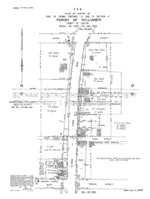
Document - Survey Plan, Country Roads Board, SP 6800, Eltham-Yarra Glen Road; Bridge St to Henry St, 1958
1958 C.R.B. Plan of Survey of Part of Crown Portions 12 and 13 Section 4 Parish of Nillumbik, County of Evelyn Eltham-Yarra Glen Road., Shire of Eltham Shows Surveyor field notes, property ownership and building type and construction.1958, a.m. gahan, a.s & s.j. davis, annie ellen davies, bridge street, country roads board, d.a. lyon, dave lyon, eltham, flora towell, g.e. gallagher, henry street, j. lyon, k. greene, main road, p.a. gahan, survey plan, w.l. chynoweth pty ltd, york street, neil webster collection -
 Greensborough Historical Society
Book, Isabel Ellender, The Plenty Valley Corridor: the archaeological survey of Aboriginal sites / by Isabel Ellender 1991, 1991_
This archaeological survey of the Plenty Valley was conducted by Isabel Ellender in 1991 for the Board of Works (Melbourne Water), in particular the Plenty Gorge Metropolitan Park. The area studied is north of Greensborough to Whittlesea. A number of Aboriginal sites were identified and recommendations made for the future.67 p., illus., maps. Plastic spiral binding.plenty river, aboriginal heritage sites, plenty gorge metropolitan park -
 City of Greater Bendigo - Civic Collection
Equipment - Rolling Parallel Ruler, Kilpatrick and Co
Kilpatrick and Co were London based Mathematical Instrument Makers, Opticians, Goldsmiths, Jewellers and Watchmakers who operated in Melbourne at various Collins Street addresses between 1876 and 1898. Believed to have been a part of the Shire of Marong's surveying equipment.Rectangular brass ruler with beveled edges and rollers on underside. Housed in custom made hinged wooden box. Centre front; Kilpatrick & Co., Londoncity of greater bendigo surveying, shire of marong -
 Phillip Island and District Historical Society Inc.
Newspaper clippings
Newspaper clipping on early history of San Remo and district, the naming of the township, San Remo Heights Estate Hall and the San Remo Post Office.Early history of San Remo, including its original settlement, surveying of the district, change of name from Griffiths Point proclaimed in the Victorian Government Gazette on 11th august, 1888. also early history of San Remo Heights Estate Hall and the San Remo Post Office. Includes a photograph of the township and fishing fleet probably taken from 1940 bridge.local history, documents, newspapers, san remo, buildings - historical, black & white newspaper clipping, san remo, post office, fishing fleet -
 Federation University Historical Collection
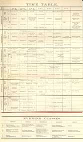
Document, Ballarat School of Mines Science Timetable, 1909, 1909
Folded card which outlines the tabletable for science subjects at the Ballarat School of Mines, 1909. Subjects include metallurgy, Mine Engineering and Metallurgu, Mine Engineering, Chemistry, Geology, Physics, Petrology, Electricity and Magnetism, Assaying, Cyanide, Mineralogy, Freehand Drawing, Assaying, Mine Surveying, Plumbing, Telegraphy and Telephony, Fitting and Turning, mining. Classes are held during the day, evenings and on Saturdays. ballarat school of mines, timetable, science -
 Ringwood and District Historical Society
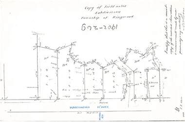
Document - Copy of Lands Department Field Notes - Subdivision Township of Ringwood, Victoria, Field Notes 1902/269 - Part of O.P. R72D surveyed in 1902
Foolscap size photocopy of survey map with handwritten notations. References include Maroondah Highway, (opposite) Mines Road, Ti tree, Sandy soil, heath, spear grass, box & stringy bark sapplings, gentle slope to creek, E. Drury. I certify that this is a correct copy of the recorded observations and measurements made by me personally and my assistant (signed) W. Thorn. -
 Ringwood and District Historical Society
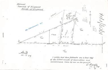
Document - Copy of Lands Department Field Notes - Parish of Ringwood, Victoria, Field Notes 1909/174 - Part of O.P. R72D surveyed 12.3.1909
Foolscap size photocopy of survey map with handwritten notations. References include Mount Dandenong Road, pathway, 2 room house, scillion, shed, WC, 17C sold, Cr lands, orchard, 17E sold, Township boundary, I certify that these field notes are a true copy of the actual results of observations and measurements taken by me on the ground (signed) D. Barker 12.3.09. -
 Bendigo Historical Society Inc.
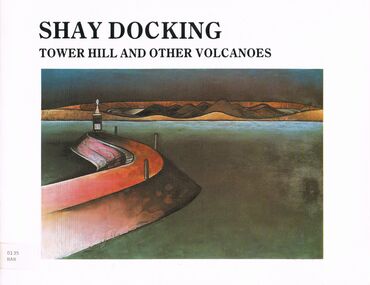
Book - TOWER HILL AND OTHER VOLCANOES
A book titled ' Tower Hill and Other Volcanoes a survey ' by Shay Docking. Warrnambool Art Gallery February - March 1987. Bendigo Art Gallery April 1987. Swan Hill Regional Art Gallery May - June 1987. Supported by the Telecom Exhibition Development Fund. Photography by Gil Docking and Greg Weight. Publislhed by the Warrnambool Art Gallery, February, 1987.artwork, tower hill, book, books, artist, tower hill, volcanoes, shay docking, female, person, individual, warrnambool art gallery, artwork, sciences, photography, place, david hansen, gil docking, survey, exhibition -
Bendigo Historical Society Inc.
Map - MARONG : COUNTY OF BENDIGO, June 1953
Map> Marong, County of Bendigo, Nerring, Sandhurst, Lockwood, Shelbourne, Woodstock, Leichardt, Bullock Creek, Fletcher Creek, Township of Marong, Bendigo Railway Line, Marong Railway Station, Crusoe Aqueduct. Drawn and reproduced at the Dept. of Lands and Survey, Melbourne, Victoria. June 1953. Price 2/-. By authority W.M. Houston, Government Printer. (number 74 in map cupboard 1)W.M. Houston, Government Printer.map, bendigo, marong -
Bendigo Historical Society Inc.
Print - ETCHING OF VIEW STREET SANDHURST 1859, 1859
Black and white etching of View Street buildings. Dudley House. Mechanics Institute. Henry Jackson. Pikes bridge with children crossing. Horses & carts. People walking. Timber slats over creek. View street going towards Barnard street. Etching copy of original. View Street. Sandhurst. 1859. Survey & Post Office. FH 566 Not Found 8.12.2022place, bendigo, view street buildings. 1859 -
Bendigo Historical Society Inc.
Map - ELLESMERE : COUNTY OF BENDIGO, 18-1-1943
Map. Ellesmere, County Bendigo, Bagshot, Wellsford, Axedale, Muskerry, Goornong, Bendigo Creek, Bendigo to Echuca- Northern Railway Line, Campaspe River, Sugarloaf Trig.Station. Township of Fosterville.By Authority: H.E. Daw, Govt. Printer, Melbourne. Drawn ad reproduced at the Dept. of Lands and Survey, Melbourne . 18-1-1943.Price 2/-. (number 37 in map cupboard 1)H.E. Daw, Government Printer, Melbourne.map, bendigo, ellesmere -
Bendigo Historical Society Inc.
Map - DIGGORRA PARISH : COUNTY OF BENDIGO, 6-9-21
Map. Parish of Diggorra, County of Bendigo, Parish of Bamawm, Rochester West, Pannoomilloo, Warragamba, Minto, Egerton, Elmore, Northern Railway, Parish of Ballendella. Elmore /Cohuna Railway. Photo-Lithographed at the Department of Lands and Survey, Melbourne by W.J. Butson, 6-9-21, Price 1/-.. By authority A.J. Mullett, Government Printer. (number 57 in map cupboard 1)A.J. Mullett, Government Printer.map, bendigo, diggorra -
Bendigo Historical Society Inc.
Map - JANIEMBER EAST : COUNTY OF BENDIGO, 15-1-34
Map. Janiember East, County of Bendigo, Jarklan, Pompapiel, Yarrayne, Powlet, Janiember West, Serpentine Creek, Caney's Blind Creek Long Plain Creek, Loddon River. By authority : H.J. Green, Govt. Printer, Melbourne. Drawn and reproduced at the Department of Lands and Survey, Melbourne, Victoria. Price 2/-. 15-1-34. (number 45 in map cupboard 1)H.J. Green, Govt. Printer, Melbourne.map, bendigo, janiember east -
 Bendigo Historical Society Inc.
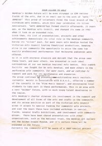
Document - MERLE HALL COLLECTION: ARTS BENDIGO: ''FROM SILVER TO GOLD''
Arts Bendigo: ''From Silver to Gold'' Two-paged draft document for submission as it has a notation: ''To Advertiser 6/95? (with) cover note''. Survey of arts development in Bendigo over a period of 25 years (ie Silver Anniversary) towards a ''Golden Future'' and recognition of the recently acquired ''solid status'' of the Regional Arts Centre. Some added alterations to draft text. -
Kew Historical Society Inc
Archive (Sub-series) - Subject File, Kew Historical Society, Genazzano FCJ, 1934
Various partiesReference, Research, InformationSecondary Values (KHS Imposed Order)Subject file containing information on Genazzano FCJ, Cotham Road. The file includes old and new newspaper articles/clippings, and a history of the Stanislaus Room. The most interesting item in the file is a damaged copy of ‘The Junior Argus’ (Thursday 10 May 1934), which includes a full-page article on Scouts and Guides: A survey of the Jamboree (by Lone Woolf), and a small article on the Genazzano Badge.genezzano fcj - kew (vic), boy scout girl guide jamboree 1934, private schools - kew (vic.), girls' schools - kew (vic.)genezzano fcj - kew (vic), boy scout girl guide jamboree 1934, private schools - kew (vic.), girls' schools - kew (vic.) -
 University of Melbourne, Burnley Campus Archives
Plan, Burnley Gardens. City of Richmond. Parish of Jika Jika - County of Bourke, 1927
Part-coloured plan showing drainage, sewerage drains, taps and waterstops. Area bounded by Swan St. To N, Yarra River on E and Richmond Park on SW side. Contour lines of orchard depicted, laying pens and yards. Coloured area depicts pavilion with surrounding garden and paths layout pencilled in. Photo-Lithograph by Dept. of Lands & Survey, Melbourne by W. Butsonsewerage, drainage, lithograph, pavilion -
University of Melbourne, Burnley Campus Archives
Plan, Burnley Gardens. City of Richmond. Parish of Jika Jika - County of Bourke, 1927
Plan showing Burnley Gardens - bounded by Swan St to N, Yarra River to E, Richmond Park on S and W side. Photo-lithographed at Dept. of Lands & Survey by W.J. Butson. Plan shows old orchard, fowl sheds, coops and yards, milking shed, silo, nursery, glasshouse, fattening pens, dairy, garden, orchards area in S.W. area.burnley gardens, orchards, sheds, nursery -
 Bendigo Historical Society Inc.
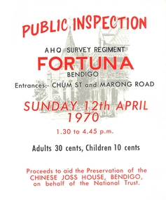
Poster - Fortuna collection: AHQ Survey Regiment
Poster advertising a public inspection AHQ Survey Regiment, Fortuna Bendigo. Entrances: Chum St. and Marong Road, Sunday 12th April 1970, 1.30 to 4.45 pm. Adults 30 cents, Children 10 cents. Proceeds to aid the preservation of the Chinese Joss House, Bendigo, on behalf of the National Trust. The lettering on the poster is in red and black with a pencil drawing of Fortuna on the background.fortuna villa, ahq survey regiment, chinese joss house -
 Queenscliffe Maritime Museum
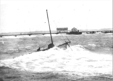
Photograph - Jurgens' Couta boat KARA, KARA, Jurgens' Couta boat, 1953
KARA Couta boatKARA Couta boat in a gale.KARA, Jurgens' Couta boat in SE gale in 1953Reverse - " late Arnold Jurgens fishing boat KARA / She was deliberately beached between the piers to save her from being wrecked like the P & H survey launch FLINDERS [refer 1985-146] / South East gale February 1953 "historical references, kara, couta boat -
 Bendigo Military Museum
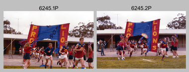
Photograph - Army Survey Regiment’s Fortuna Lions Football Club Grand Finals, Seymour, Victoria, 1983
This is a set of 25 colour photographs of Army Survey Regiment’s Australian Rules football team – the Fortuna Lions aka “Fortuna Fumblers”, taken at Seymour Victoria in 1983. The 26th item is a A4 paper document detailing the history of Fortuna Football Club from 1978 to 1993. The Fortuna Lions competed in the Puckapunyal Area Football Association for several years from 1978 to 1984 and in 1983, fielded a great team it managed to reach the Grand Final. Held at the neutral ground at Kings Park, Seymour, the match was an incredibly exciting and bruising contest played in damp conditions and ended in a draw. Dave Lawler’s spectacular mark was a highlight. Due to heavy rain during the following week, the Grand Final replay was held the following week in even heavier conditions. The Fortuna Lions prevailed in the replay with an emphatic victory. The team’s leaders were Eddie Jacobs (coach), Rhys De Laine (captain), Greg Else (vice-captain), and Ken Slater (manager). See items 6244.27P and 6274.7P for more photographs taken at the two grand finals. Although not part of the photo collection, the team photo with names .24P and a photo of the premiership banner .25P are included. The team changed its name to the Fortuna Falcons and its guernsey to gold with a blue ‘V’ in 1988 and continued to compete in the competition up to 1995.This is a set of 25 photographs of Army Survey Regiment’s Australian Rules football team – the Fortuna Lions aka “Fortuna Fumblers”, taken at Seymour Victoria in 1983. The 26th item is a A4 paper document detailing the history of Fortuna Football Club from 1978 to 1993. The photographs were printed on photographic paper They are part of the Army Survey Regiment’s Collection. The photographs were scanned at 300 dpi and the document at 200 dpi. Fortuna’s footballers named below are in Fitzroy jumpers. .1) - Photo, colour. 1983. L to R: Nick Van Dalen, Jim Ash, Dennis Learmonth, Greg Higgins, Dave Lawler. .2) - Photo, colour. 1983. L to R: Terry McIntyre, Andy Godden, Rod Skidmore, Alan Staley, Carmel Butler, Gayle Humphrey. .3) - Photo, colour. 1983. L to R: Greg Else, Doug Home, Wendy Leitinger, Leah Hoffman, Carmel Butler, Ken Talbot-Smith. .4) - Photo, colour. 1983. L to R: Leah Hoffman, Carmel Butler, Kristin Skidmore, Neville Carr, Brian Fauth on right of banner. .5) - Photo, colour. 1983. L to R: Dave Lawler, Larry Thompson, Rod Skidmore, Greg Higgins, Gayle Humphrey. .6) and .7) - Photo, colour. 1983. Army Survey Regiment, 1st Armoured Regiment and officials line up before game. .8) - Photo, colour. 1983. L to R: unidentified (x2), Kristin Skidmore, Carmel Fauth, Leah Hoffman, Wendy Leitinger, Gayle Humphrey, Di Weston, unidentified, Rob Straube. .9) and .10) - Photo, colour. 1983. Competition’s individual award recipients. Eddie Jacobs in white shorts. .11) and .12) - Photo, colour. 1983. Fortuna’s supporters on boundary. .13) to .15) - Photo, colour. 1983. All players unidentified. .16) - Photo, colour. 1983. Dave Lawler launches to take a spectacular mark. .17) - Photo, colour. 1983. L to R: Stu Ridge (No.2) Eddie Jacobs (No.16), and (No.9). .18) - Photo, colour. 1983. L to R: unidentified (No.9), unidentified, Alan Staley (No.7). .19) - Photo, colour. 1983. L to R: Alan Staley (No.7), unidentified (No.17), unidentified, unidentified (No.9), Greg Higgins (No.20). .20) - Photo, colour. 1983. All players unidentified. .21) - Photo, colour. 1983. Peter Jones (No.5) .22) - Photo, colour. 1983. L to R: Greg Higgins (No.20), unidentified, Alan Staley (No.7). .23) - Photo, colour. 1983. L to R: Unidentified, Greg Byers (No.19). .24) - Photo, colour. 1983. Fortuna Football Club Team Photo. .25) - Banner, colour. 1983. Fortuna Football Club Premiership Banner. .26) - Document, black & white. 1993. History of Fortuna Football Club from 1978 to 1993..1P to .23P – no annotations .24P – Members of team named on bottom .26 - A4 size paper document of the team’s history.royal australian survey corps, rasvy, army survey regiment, army svy regt, fortuna, asr -
 Orbost & District Historical Society
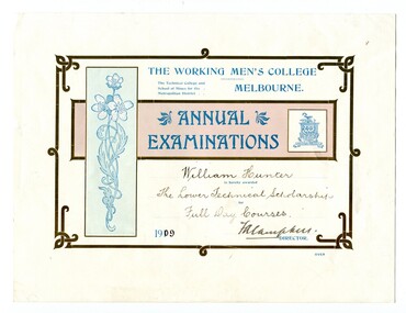
certificates, 1909, 1911, 1912
These four certificates belonged to William Hunter. William Hunter (1893-1971) was a resident of Tatura and Mallacoota. He was a soldier, surveyor and amateur naturalist. The certificates include two first prizes for surveying, a technical scholarship for full day courses and a certificate for Applied Mechanics. William received his Surveying Certificate in April 1916. In June 1887, the Working Men's College opened after Francis Ormond, a noted Victorian philanthropist and member of parliament, suggested that a technical institute be built in Melbourne, offering further education for working men and women. He had offered to match the sum raised through public subscription if the government could provide a site for the College. William Hunter made valuable contributions to our knowledge of far East Gippsland plants. His records were meticulous. These certificates are part of his history.Four card certificates of merit for "Annual Examinations" from the Working Men's College, The Technical College and School of Mines for the Metropolitan District.All four certificates awarded to "William Hunter" and signed by Mordaunt Arundel Hall (accountant & chief clerk WMC) as the Acting Director.hunter-william-surveyor -
 Stawell Historical Society Inc
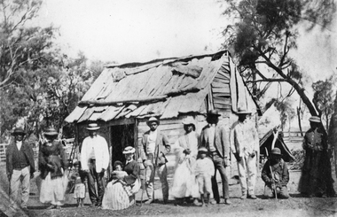
Photograph, Indigenous or First Nations People at Carrs Plains 1874 Richardson River Tribe
Photo taken at Carrs Plains in 1874 of Indigenous or First Nation People outside a wood and bark hut. In 1861, William Dennis of Carrs Plains Station, a staunch Methodist became Honorary, Aboriginal Protector for the area. One of his main tasks to give Government supplied food and clothing to the Aboriginals. Many district, remaining Aborigines became based at Carrs Plains, and their dead were buried in a cemetery on the station. The cemetery is show on survey map of Wirchilleva Borough, in corner of camping & water reserve near surveyed Bismarck township. In a Protector's report 1869, Dennis wrote that only one male worked regularly on the property, a Bullock driver.Black and white photograph of a wood and bark hut with a group of men, women and children out the front. Richardson River Tribe.Anthony & Lubra, Donald & Affie my ? Herbal? Black Billie Great Rider, Kitty Supulants? Lubra Jonny Callaghan Jr., Four? Supulant? Harry, Blind Tommy & Lubra, 1874 Reproduction rights reserved Copied by State Library of Victoriastawell aboriginal portrait -
 Greensborough Historical Society
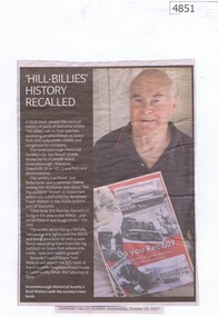
Newspaper Clipping, Diamond Valley Leader, 'Hill-Billies' History Recalled, 25/10/2017
A new book "Do You Recall?" reveals the unusual history of parts of Watsonia where "hill-billies" sat on their porches surveying an area known as Grace Park with only cattle, rabbits and kangaroos for company. The book is available from the Greensborough Historical Society. News article 1 page, black text and colour image.grace park, greensborough historical society, do you recall -
Ringwood and District Historical Society
Invitation card, Ringwood Historical Research Group AGM Invitation card 1967, 26-Jul-67
Invitation from President of RHRG, E.V. Pullin & secretary B.M. Jamieson to Mr. K. Ward, Chamber of Commerce, to be present at the 1967 AGM. Speaker was Mr. H.S. McComb on "Development of Region East from Melbourne 1837-1860 According to Government Surveys".Buff coloured card marked Ringwood Historical Research Group inviting person to annual meeting on Wed 26-Jul-1967 in Lower Town Hall, Ringwood, at 8pm +Additional Keywords: Pullin, E.V. / Jamieson, B.M. / Ward, K. / McComb, H.S. -
 Federation University Historical Collection
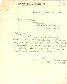
Letter, S.G. Turrell, Letter from S.G Turrell of the Brownhill Consols Ltd to the Ballarat School of Mines, 28/3/1911 (exact)
S. G. Turrell was a student at the Ballarat School of Mines and passed the Chemistry, Assaying, Metallurgy, Mineralogy and Geology in 1903 and Chemistry II, Metallurgy II, Steam and Gas Engines, Technical Chemistry, Mine Surveying, Electricity, Mining Geology and Engineering Drawing in 1904Two quarto pages. One from S.G. Turrell on Brownhill Consols Ltd letterhead asking Fred Martell of the Ballarat School of Mines for details on obtaining certificats. The second page is a list of the subjects passed by S.G. Turrell in 1903 and 1904university of ballarat, ballarat school of mines, fred martell, s g turrell, f j martell -
 Robin Boyd Foundation
Booklet, P. R. Boyd, Survey on Melbourne, 1960
In 1960 when he was 11 years old, Penleigh Boyd, Patricia and Robin's son, created this 'Survey on Melbourne’ as a school project. He went on to study architecture at the University of Melbourne and the University of Sydney. He has worked as an architect in Canberra since 1976.Notebook with handwritten notes in blue ink and newspaper clippings (which open), paper cover.walsh st library, ohm2022, ohm2022_37 -
 Linton and District Historical Society Inc
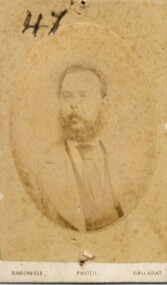
Photograph, Bardwell, Ballarat, Denis Cronin, Linton school teacher 1873, 1873
Part of Old Lintonian collection ; No. 47. Mentioned in 1939 "Historic Souvenir of the Linton Centenary" as being on the staff when Linton State School No. 880 opened in 1873. Mentioned as one of original staff in "Linton SS No. 880 : Brief Historical Survey" (1967).CDV (carte de visite) sepia portrait of a man with beard and moustache, wearing jacket, shirt and wide tie.denis cronin, linton state school no. 880, old lintonian collection -
 Bendigo Military Museum
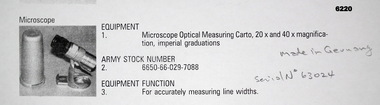
Instrument - Microscope Optical Measuring Cartographic, Hensoldt Wetzlar, Circa 1960
A very accurate microscope for measuring cartographic line-weights (thickness) during the Mapping process. Could be used to measure positive or negative line-weights or scribed lines in imperial measurements. Used at the Army Survey Regiment during the manual production of maps or charts.Silver alloy protecting Tube 5.5cms diameter and 12cms in height containing a Cartographic Microscope with imperial measurements. The Microscope is capable of 20 to 40 times magnification.Manufactured by "HENSOLDT WETZLAR" Serial Number 63024royal australian survey corps, rasvy, fortuna, army survey regiment, army svy regt, asr