Showing 4244 items matching " prior"
-
 Tatura Irrigation & Wartime Camps Museum
Document, Alois Murr, Alois Murr Papers, 1938 to 5 October 1945
Herr Alois Murr, trouble shooter, Lanz Tractors prior to war, was subsequently interned, then released, became a citizen of Australia. Drawings of the single cylinder were donated by Stephen Larcombe "Pinebrow" Reservoir Road, Pettarel 3216. An interesting account of Mr Murr's longer than expected sojourn and subsequent residence in Melbourne Australia.a red coloured hard back cover on the front cover on white self adhesive paper on which is printed in ink - Alois Murr Papers - internee, camp 1 Tatura - presented by Eric Bolwell Horsham October 1994as abovealois murr, lanz tractors, camp 1 internees -
 Uniting Church Archives - Synod of Victoria
Printed image, Undated
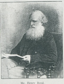
Henry Reed was a Methodist lay preacher. Successful tin whaling and farming enterprises, he may have conducted services in Portland prior to 1834. He is reputed to have preached the first Methodist service in Melbourne "to Henry Batman, his brother and three Sydney blacks". He was a man of much wealth and prestige in the colonies.Print (for publication) of a B & W waist length seated portrait of Mr Henry Reed. Mr Henry Reed -
 Wodonga & District Historical Society Inc
Domestic object - Hand hair clippers, Brown's Clipper Co. Ltd, c1940
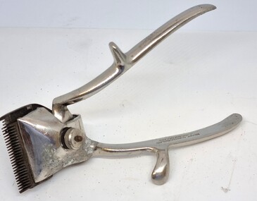
Hair and beard clipping was frequently carried out at home prior to WW11 and often much later in rural areas. Manual hair clippers were readily available for purchase. Brown's Clippers were a popular choice for many Australian men. This company was based in BIrmingham, England and operated from 1939 until the end of the 1950s. This item has significance as a common item for men both domestically and commercially in the middle decades of the 20th century.A set of manual hair clippers made of chromed steel. An adjustable screw allowed blades to be interchanged.BROWN'S CLIPPER CO (1939) LTD / BIRMINGHAM.ENGLANDhair clippers, home barbers, brown's clipper co. ltd -
 Melbourne Tram Museum
Slide - Black and white reproduction photograph - PMTT tram 4 Glenferrie Road 1910
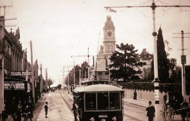
Photograph - PMTT tram 4 Glenferrie Road 1910, possibly undertaking testing prior to the official opening on 30/5/1910. Photo shows the centre of the road overhead support poles in Glenferrie Road and a "Hail Cars Here" sign. In the background is the Malvern Town Hall, signs for Norwich Union and Walter Wright Hairdresser.Yields information about the opening of the tram lines built by the PMTTKodachrome cardboard duplicate slide - Black and white reproduction photograph - PMTT tram 4 Glenferrie Road 1910 "MP5" in penciltrams, tramways, opening, tram 4, pmtt, glenferrie road, tram stop -
 Wangaratta RSL Sub Branch
Uniform - Brassard, Interfet, c1999
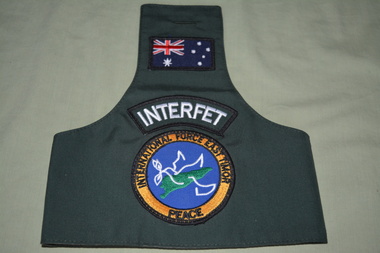
INTERFET (International Force East Timor) brassard worn by all service personnel from all participating nations in Timor between October 1999 and February 2000, prior to the United Nations resuming control. INTERFET was commanded by an Australian, Major General Peter Cosgrove and approximately 7000 Australian service personnel were deployed. The International Force East Timor (INTERFET) was a multinational non-United Nations peacemaking taskforce, organised and led by Australia in accordance with United Nations resolutions to address the humanitarian and security crisis that took place in East Timor from 1999–2000 until the arrival of UN peacekeepers. Dark green army brassard with three patches.Australian flag patch, Interfet patch, International Force East Timor Peace patch.brassard, arm band -
 The Beechworth Burke Museum
Postcard
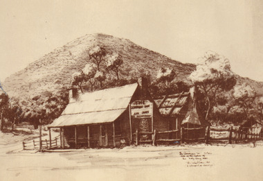
This Australian yesteryear postcard was published by Cobb & Co in circa 1990. It is a sepia toned artwork of the Ann Jones Inn in Glenrowan which was taken prior to 1880. The building at rear in this photograph was the private residence of Ann Jones, a migrant from Tipperary, Ireland. Two years after building her private residence, in 1878/1879, Ann Jones added the Inn to the front of the building which is depicted in the postcard. In 1880 the Inn was burned to the ground during the Kelly Gang siege. After the siege, Ann Jones and her children continued to live on the same location in a makeshift hut. This hut was later replaced with a dwelling using compensation money provided to Ann from the government for the loss of her property and goods; however, she was denied a new trading licence which did not enable her to re-establish her previously successful business. The reverse of this postcard provides a snippet of information into the Glenrowan siege, for which this site is most well-known. It outlines the role and demise of the members of the Kelly Gang but what it does not include is how Ann Jones, owner of the Inn depicted on the postcard, was impacted. Ann’s son of 13 years, Johnny was killed during the siege, and a bullet grazed the forehead of her daughter, Jane Jones. Jane would die two years after this event from tuberculosis, but it was believed by Ann that the cause was grief for the death of her brother and distress at having witnessed the siege. Ann was provided with 100 pounds in compensation money for the loss of her children. Her husband, Owen Jones passed away late 1880 and in 1891 Ann Jones remarried. She died at the age of 80 in 1910. The “last stand” of the Kelly Gang at this location is estimated by Dr Stuart Dawson of Monash University to have taken less than 10 minutes in duration. During and following this time, the life of Ann Jones was turned upside down and everything she had worked for in the preceding years was now in ruins. This postcard has the capacity to reveal information about the popularity of the Kelly story in Australia. It was created in approximately the 1990s which perhaps reveals a resurgence in interest into the Kelly Gang and Australian history when card was made. This image, and others depicting the Ann Jone’s Inn, have the ability to shed light on the Kelly story and the events of the Glenrowan Siege. Additionally, they can reveal information into the life of a female business owner during the 1870-1880 period. Archaeological research has been conducted at this site by LaTrobe University and a study of these images alongside the analysis of the material culture found at this location can help to build more comprehensive understanding into life in Australia during this period and Ann Jones herself.Sepia rectangular postcard printed on cardObverse: [Illegible] Reverse: G4/ 3276/ Australian / Yesteryear / cards/ correspondence / address / Published by Cobb & Co (03) 5766 2409 / The Glenrowan Inn owned by Ann Jones. / It was this Inn in which the Kelly Gang imprisoned / 62 people, while waiting for the special train / carrying the police to arrive from Benalla. On 28th / June 1880, following a seige which lasted over 12 / hours, Ned Kelly was captured. Joe Byrne was shot, / and the Inn was set on fire in an attempt to flush out / the two remaining outlaws, Dan Kelly and Steve / Hart. However, some time prior, the two boys, it / was believed, had committed suicide, as a result, / their bodies were incinerated beyond recognition. / A sepia tone facsimile of / an early Australian photograph. /kelly album, postcard, glenrowan inn, kelly siege, australia yesteryear card, cobb & co publisher, ned kelly capture, jones ann, dan kelly, joe byrne, steve hart, fire, train, police, benalla, 28 june 1880 -
 Frankston RSL Sub Branch
Souvenir Ashtray
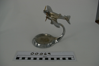
Miniature model of a WW2 era Avro Anson twin engine aircraft mounted on an ashtray. The aircraft is supported by a curved arm attached to the circular ashtray base. The base has a small metal RAAF 'winged eagle' insignia attached to the front edge. The items have been made from chromed metal materials. The RAAF was equipped with Avro Anson aircraft in the late 1930 period prior to WW2. These aircraft were used by the RAAF for general and maritime reconnaissance and training throughout WW2 and into the early 1950s. The first version of the Avro Anson was developed in 1935 by the British Avro aircraft company.Chromed metal RAAF 'winged eagle' insignia on the front edge of the base.plane, trench art, ashtray, aircraft, souvenir, avro anson -
Frankston RSL Sub Branch
Framed Gravure Print, unknown, 2015
Framed print produced by the gravure process. The print is in sepia tonings and depicts a military scene, presumably Turkish. The print is mounted with a brown wooden frame and glass front. Artist is Erol Yildirim, born 1959 in Bolu, Turkey. The print is number 51 of 100 and is dated 2015. This print was presented to the President and members of the Frankston RSL Sub Branch by the people of Turkey in early 2015 (just prior to the 100th Anniversary of the Gallipoli landing). The rear of the print has a brief biography of the artist and an explanation of the process used to produce the print attached. There is also a 'with compliments' slip from the Embassy of Turkey, Canberra attached.This print is marked "51/100" and has the artists name "Erol YILDIRIM 2015" -
 Bendigo Historical Society Inc.
Document - H.A. & S.R. WILKINSON COLLECTION: CONDITION OF SALE
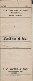
Conditions of sale of freehold land & dwelling by private contract dated 2nd April, 1930, issued by T.C. Watts 7 Son licensed Real Estate Agents between R. Fletcher and T.G. Fletcher executors of the will of R.H Fletcher deceased (sellers) and J. Prior (buyer) for land being Crown allotment 5 section 24 at Eaglehawk having frontage to Campbell Street of 85 links by a depth along Church Street of 223.5 links, land described in certificate of title volume 1541 folio 308073, together with all buildings and erection thereon. Price 415 pounds.organization, business, h.a. & s.r wilkinson real estate -
 Bendigo Historical Society Inc.
Newspaper - JENNY FOLEY COLLECTION: BENDIGO ADVERTISER
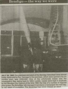
Bendigo Advertiser ''The way we were'' from 2000. July 29,1962: the premises and plant of the Bendigo Advertiser were almost totally destroyed by fire. Damage to the premises, which were opened only six month prior was 250,000 pounds. One of the unfortunate losses was the newspaper's files dating back to 1853. Luckily, copies were kept in duplicate by the Bendigo City Council of the time. With the help of a number of regional print shops, the Advertiser still managed to produce a newspaper the next day. In 147 years of production The Advertiser has never missed an issue. The clip is in a folder.newspaper, bendigo advertiser, the way we were -
 Southern Sherbrooke Historical Society Inc.
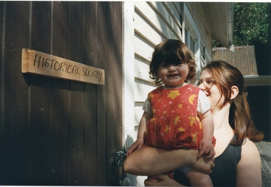
Photograph - Rowan and Rhiannon Matta, out the front of the Southern Sherbrooke Historical Society's building, 1997
Colour photo of Rowan Matta, aged one, being held by her mother, Rhiannon Matta, out the front of the Southern Sherbrooke Historical Society's building prior to Rowan getting her vaccinations at the Progress Hall next door. Rowan is wearing a red dress with a yellow stars -and-moon pattern over a white shortsleeved top, and Rhiannon is wearing a black sleeveless top. The society's hall and their church in the background are still in the condition they were in when moved from Belgrave South School. On the door of the hall is a handwritten sign, 'Historical Society'. Photo taken by Marian Matta. -
 Southern Sherbrooke Historical Society Inc.
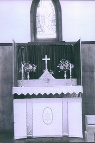
Photograph - Altar and window, St Martins Church, Belgrave South
B&W photo showing the altar in the St Martins Anglican Church, Belgrave South, prior to its relocation. The photo shows the wooden altar, covered with a gold and white altar cloth and a white lace overlay. On the top are two candlesticks and a small vase with flowers, and behind them in a raised part are two larger vases with flowers and a cross on the top of a stepped plinth. The top of the altar is surrounded by riddels (curtains) supported by riddel posts. On the wall behind the altar is the stained glass window, 'The Light Of The World'. In front of the altar on the right can be seen part of the railing between the sanctuary and the nave. -
 Ballarat Tramway Museum
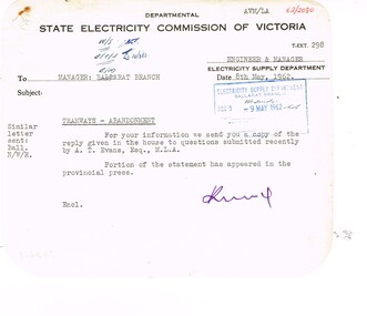
Administrative record - Memorandum, State Electricity Commission of Victoria (SECV), "Question to be asked without notice by A. T Evans Esq MLA in the Legislative Assembly on 2nd May 1962", May. 1962
Memorandum and a copy of a report concerning a "Question to be asked without notice by A. T Evans Esq MLA in the Legislative Assembly on 2nd May 1962". All with rounded corners. .1 - Memo dated SEC paper typed, sending to Ballarat a copy of the Question and response. .2 - Copy of the question and response on heat sensitive paper, concerning the suggestion of the AETA to use in Ballarat trams ex Footscray and that the State does an independent survey prior to any potential closure of the Ballarat system. Response from The Minister, responding to the suggestion, trams unsuitable, economics, and that a bus service to the satisfaction of the TRB is proposed.trams, tramways, closure, letters, aeta, footscray, parliament -
Ballarat Tramway Museum
Document - Photocopy, Lloyd Jenkins, Oral History Transcripts, 1987
Photocopy of a transcript prepared by Lloyd Jenkins and draft copy with corrections in red ink of an interview with Mr. H. G. Gilbert at his home at 423 Skipton St. Ballarat, 23 March 1987. Mr. Gilbert was a SEC Linesman and was 80 years old at the time. The interview reviews Mr. Gilbert working life prior to starting with ESCo, joining the SEC, WW2, the Guncotton or munitions plant in Ballarat West, power supply, DC power supply, stories, the Social Club (EST). Interview comprises 15 sheets of A4 paper. The draft copy comprises 35 pages.trams, tramways, oral history, audio tape transcripts, sec, linesman, esco -
 Ballarat Tramway Museum
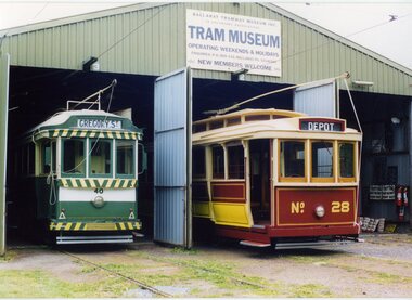
Photograph - Black & White Photograph/s - set of 3, Carolyn Dean, 27/10/2002 12:00:00 AM
Set of three photographs taken by Carolyn Dean on 27.10.2002 prior to the launch of BTM No. 28 on the day of the BTM AGM. On Kodak paper. 2232.1 - No. 40 and No. 28 standing at the depot doors. A similar photo to that taken during 1972 when the BTPS was operating out of the former SEC Depot - see Reg. Item 1177.5. Photo used in November 2002 Fares Please! See Reg Item No. Three copies held. 2232.2 - Photo of No. 26 and 28 standing alongside each other. 2232.3 - ditto with 26 in the foreground - photo used in November 2002 Fares Please! Two copies held.On rear of each photo "27.10.02" and "Photo by Carolyn Dean"tramways, trams, btm, tramcar launch, depot, tram 28, tram 26 -
 Ballarat Tramway Museum
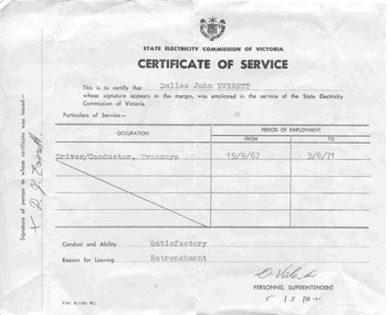
Certificate, State Electricity Commission of Victoria (SECV), "Certificate of Service", 5/08/1971 12:00:00 AM
Significant for shows the form and method of issuing a certificate of service for a specific person, his duties, and performance. Signed by the person who received the form. Shows that the person was retrenched by the SEC prior to final closure of the tramways.Single sheet of off white or light grey paper, titled "Certificate of Service" prepared by the State Electricity Commission of Victoria (SEC) for 'Dallas John Everett". Pre printed certificate form "FMI 5-190 R2". Occupation given as "Driver/Conductor, Tramways" for the period from 19/9/1967 to 3/8/1971. Gave conduct and ability as "Satisfactory" and reason for leaving "Retrenchment". Issued on 5/8/1971 by Personnel Superintendent. Has D. J. Everett's signature on left hand margin. Appears took retrenchment prior to the first of the tram lines closing.tramways, trams, sec, certificates, ballarat, retrenchment -
 Ballarat Tramway Museum
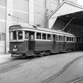
Photograph - Black & White Photograph/s - set of 2, Geoff Grant, 2/04/1955 12:00:00 AM
Black & White photo of SECV Geelong No. 39 standing outside Geelong depot shed, prior to running in AETA tour on 2/4/1955. Destination showing "SPECIAL" and AETA tour board on front bumper of tram. N261 envelope - "One man operation car No. 39 standing outside depot. AETA Tour, Geelong 2nd April 1955" .1 - Copy large format print from Lloyd Rogers collection via Robert Green 2/2014. Added 4-4-2019 Original negative scanned at hi res 18/5/2020 and image updated.On rear in typed paper "Car no 39 one man operation car standing at Geelong depot for AETA tour. April 2 1955" and "Geoff Grant" stamp on btm rh corner. .1 - In ink in bottom left hand corner - "Geelong Depot - One man car 2-4-1955"trams, tramways, geelong, aeta, tours , tram 39 -
 Ballarat Tramway Museum
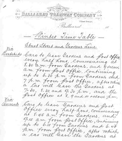
Document - Photocopies, Gold Museum, Winter Timetable of the Ballaarat Tramway Company, 1999
Photocopy of the Winter Timetable of the Ballaarat Tramway Company, horse trams, dated c1890, detailing the services on the various lines. Comprises three separate A4 pages. Each sheet has the letterhead of the Ballaarat Tramway Company Limited, of 7 Camp St. Details services on the Gardens line via Boatsheds, via Convent, Post Office and Pleasant St., Drummond St, Lydiard and Macarthur St, and Skipton St. Noted that Saturday and Sundays were as at present. Alan Bradley - notes prior to 1893, no tramway services to Sebastopol. Sourced by Alan Bradley from the Gold Museum archives.trams, tramways, timetables, ballaarat tramway company, horse trams -
 Ballarat Tramway Museum
Newspaper, "From Horse Tram to Trolly Bus" (note spelling), pre 1940
Newspaper clipping contained within Reg. Item 2526, page 10, titled "From Horse Tram to Trolly Bus" (mis-spelt word) recording the history of the cable trams in Melbourne, the formation of the company, prohibition of steam locomotives, costs, mechanical problems, Council objections, rails, visit of Mr. Hallide, court actions, King St. track, take over by the MMTB and that "conversion war still rages" - and perhaps trolley buses. Has been cut out from a sheet and pasted into the book. Written prior to final conversion in Melbourne in 1940. Note Item Not formally Numbered.melbourne, cable trams, tramways -
Ballarat Tramway Museum
Newspaper, "Worked 27 years without holiday", 1940
Newspaper clipping contained within Reg. Item 2526, page 48, titled "Worked 27 years without holiday" about the working conditions on early Melbourne cable trams. Quotes Mr. John Cain (Senior) about the working conditions on the Clifton Hill and Northcote cable trams that are about to be replaced by double deck buses. Compares working conditions with that of the MMTB. Notes that some employees worked 27 years without a holiday. Notes pay rates, retirement gratuity, the history of the Northcote services, private operation and Municipal operation prior to MMTB operation. Note Item Not formally Numbered. melbourne, cable trams, northcote, clifton hill, personnel -
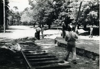 Ballarat Tramway Museum
Photograph - Black & White Photograph/s - set of 2, Nov. 1974
Has strong association with the event of laying the track across Wendouree Parade during Nov. 1975, an essential task to enable the re-opening of the tramway by the BTPS.Black and white photograph of rails being laid to cross Wendouree Parade to access the new BTPS depot access track. Excavation done. Date of photographs late November 1974. Depot Junction in background. BTPS Annual report states that site work began 22/11/1974. Has date stamp of "8.1.75" on rear of photograph. .1 - prior to first main curve rail being positioned using a crane. .2 - after first curved rail laid - see also Reg Item 1633. See also Reg Item 1633 for another photograph on the same day.tramways, trams, btps, wendouree parade, track laying, depot junction -
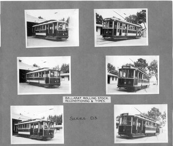 Ballarat Tramway Museum
Photograph - Black and White photograph/s - mounted, State Electricity Commission of Victoria (SECV), c1936
Demonstrates an aspect and yields information about the reconstruction and presentation of the tramcar fleet during the reconstruction by the SEC of the Ballarat Tramway system.Set of six black and white prints of the reconditioning of the tramcars during 1936 mounted onto a grey light cardboard sheet. Each photo about 65 x 90. Marked as "Series D3" in ink and a label - in on white paper - "Ballarat Rolling Stock / Reconditioning & Types" at the top of the sheet. Produced by the SEC c1936. Photographed at the depot. See Reg Items 1359, 541, and 1360 for larger prints of these photographs. Features trams 21, 22, 29 and Adelaide 69 prior to reconditioning and after. See Reg Item 4289 for a separate photo of No. 69 See image i2 for tram 21trams, tramways, depot, reconstruction, tramcars, adelaide, tram 21, tram 22, tram 29, tram 69 -
 Ballarat Tramway Museum
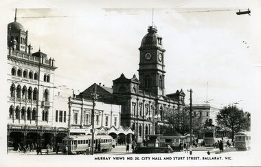
Photograph - Black & White Photograph/s, Murray Views, Murray Views No. 26 City Hall and Sturt St Ballarat Vic, c1950
Demonstrates a typical street view following the delivery of the bogie trams following the second world war and the street scape at the time. Able to determine the tramcar numbers. Yields information about the era of the photograph.B&W print, postcard print of Sturt St Ballarat, looking towards the Town Hall from the Post Office, City terminus. Photo taken by Murray Views to form "Murray Views No. 26, City Hall and Sturt St, Ballarat Vic." No. 22 on south side and No. 34 on north side - see Hi-Res scans. Has the National Mutual, Town Hall and Myers and other buildings in the view. Photo taken c1950, prior to renumbering of No. 22. 2nd copy added 28-12-2021 - most likely a reproduction of the original as it does not have a postcard back.On reverse side - black ink stamp "E.G.Butland" On reverse of 2nd copy - "Ballarat, Sturt St, west from Lydiard Sts" and Keith Kings stamp.tramways, trams, sturt st, bogie trams, tramway centre, town hall, tram 22, tram 34 -
 Ballarat Tramway Museum
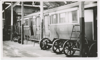
Photograph - Digital image, Wal Jack, Ex MMTB 42 after delivery to Ballarat, 17/08/1951
Yields information about Ballarat 's No. 39, when it was numbered MMTB 42 and the internal arrangements within the depot.Digital image from the Wal Jack Ballarat Album of Ballarat 39, when still with its MMTB number - 42 inside the depot 17-8-1951. Has a number of wheel sets in the foreground. See rear of photos for other details. See image i2 for rear of photograph. See image i3 for hi res scan of print. See image i4 for hi res scan of negative See image i5 for another view of the tram in the depot on the 125 negative. See Reg Item 6415i for a photo of the tram in Coburg Depot prior to delivery.On rear in ink "SEC Ballarat ex M&MTB 42 "C" class now No. 39 (in service Dec. 1951). Wendouree depot, Ballarat". In top right hand corner is Wal Jack stamp with no negative number written in.trams, tramways, depot, bogie trams, mmtb, tram 39, tram mmtb 42 -
 Ballarat Tramway Museum
Photograph - Digital image, Wal Jack, 18/02/1940 12:00:00 AM
Yields information about Lydiard St North at the time of the removal of the centre poles.Digital image from the Wal Jack Ballarat Album of a photograph looking south from Mair St along Lydiard St North prior to the removal of the centre poles, with No. 31 in the distance. A number of parked cars in the view. Has a light streak on the left hand side and the George Hotel. Wal's album notes "No. 31 in Lydiard St 18/2/40 central poles removed next day." See image i2 for rear of photograph. See image i3 for hi res scan of print. See image i4 for hi res scan of negativeOn rear of photograph in ink "T136 Ballarat No. 31 in Lydiard St a week before centre standards were removed. Photo W. Jack"trams, tramways, lydiard st nth, poles, tram 31 -
 Ballarat Tramway Museum
Photograph - Digital image, 1970s
Yields information about the Bakery Hill Victoria St and the Caltex Service Station.Digital image, black and white, of No. 26 descending Bakery Hill to Stone's Corner, Victoria and Main St with the Caltex service station in the foreground. Has a lady with slacks walking across the road and a boy wheeling a bike down the footpath. Note the Highway direction signs and service station signage. O'Brien Motors and a book and record shop on the north side Bakery Hill Victoria St. shops. See Reg 4603 for the subsequent photo at this location. Photo taken by Peter Bruce 1970's and 1971, prior to the closure of the Ballarat tramway system. Peter's Title of image: "No. 26 Bridge and Vic1"trams, tramways, victoria st, main st, stones corner, bakery hill, tram 26 -
 Falls Creek Historical Society
Photograph - Bogong Trip 1951- Mt. Bogong from above Roper's Hut
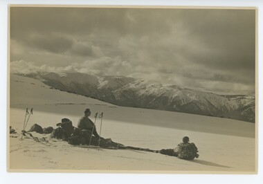
MEYER COLLECTION - FALLS CREEK PHOTOS In 1947 a determined group of like-minded State Electricity Commission (SEC) staff including Ray Meyer, the chief surveyor of the Kiewa Hydro-Electric Scheme, had a common interest that revolved around the skiing potential of the snow-covered high plains which included what is now the resort of Falls Creek. The six SEC employees, Toni St Elmo, Ray Meyer, Jack Minogue, Lloyd Dunn, Adrian Ruffenacht and Dave Gibson (together with their families) banded together to secretly build a 'hut' that was the first ski lodge at Falls Creek. Using a road built in 1930s to gain access to Falls Creek, their hut project was carried out in secret as efforts by other skiers were blocked by H.H.C. Williams – the engineer in charge of the Hydro Scheme. In 1946 Ray Meyer made a trip to the Lands Office in Melbourne. He came away with a 99-year lease on three acres that was ideally suited for a hut designed by Lloyd Dunn. Adrian Ruffenacht (Design Engineer for the KHS) had suggested where the group should build because of easy access to a spring for water. Much of the building material required was scavenged from derelict huts on the high plains. Due to the need for secrecy, the determined group worked on the hut in the evenings and weekends to avoid detection. During the building period the group had met at Echidna Rock (now known as Eagle Rock) where Skippy St Elmo announced, "This is my favourite ‘Skyline’.” And so the first lodge in the area at Falls Creek Ski Resort came into existence. With the development of the International Poma in the 1970s, the Skyline Lodge, which was sited between the ski-lift’s pole one and pole two, was demolished. However, the legacy of Ray Meyer, Toni St Elmo, Jack Minogue, Lloyd Dunn, Adrian Ruffenacht and Dave Gibson and Skyline lives on in the vibrant atmosphere of Falls Creek Resort. The MEYER COLLECTION documents developments on the Kiewa Hydro Scheme and their life at Falls Creek from the mid 1930s to 1960s.This image is significant because it depicts aspects of the life of a pioneering family of Falls Creek and the founders of "Skyline", the first lodge at Falls Creek.Black and White Image of Mt. Bogong from above Roper's Hut with Wal Johnson and Ray Meyer seated on the ground. ROPER'S HUT Frederick Roper and his family grazed the Bogong High Plains from the 1890s until 1908. Frederick "Jack" built three huts. The hut known as Roper’s Hut was built on Jack's new grazing lease after his former run had been acquired by the SEC in the late 1930s. It had become a well-used refuge hut prior to its destruction in the 2003 bushfires. It was rebuilt by Victorian High Country Huts Association in 2008.falls creek, bogong high plains, wal johnson, ray meyer, ropers hut -
 Bendigo Historical Society Inc.
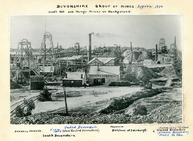
Photograph - SNOBS HILL AND MUNGO MINE IN BACKGROUND, 1876
Black and white photograph on cream board. View across mining area showing at least 9 poppet heads, 11 chimneys and many bujildings associated with the mines. C-L flume, wood stacks, mullock heaps. Text on photograph: MNG 69 on TL corner. Devonshire Group of Mines - Approximately 1876. Snob's Hill and Mungo Mines in background, Duchess Tribute, United Devonshire, from 1902 (West United Devonshire), South Devonshire, Pheonix, Duchess of Edinburgh. From 1902 called United Devonshire (Princess Alexandra) prior to this. In image 'Duchess Tribute'. On weatherboard building at C.place, mining site, see also 2000 - 426.1, 2000 - 437.01, 2000 - 438.01, 2000 - 439.01, 2000 - 507.01, 2000 - 508.01, 2000 - 509.01 -
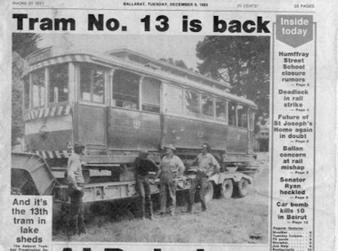 Ballarat Tramway Museum
Newspaper, The Courier Ballarat, "Tram No. 13 is back", 6/12/1983 12:00:00 AM
Yields information about the arrival back in Ballarat of No. 13 from Lake Goldsmith, prior to unloading.825 Front page (& rear page) of the Ballarat Courier of Tuesday Dec. 6, 1983 featuring with a photograph of the return of the SECV Ballarat No. 13 to the BTPS depot. Sub heading of "And its the 13th tram in the lake sheds". Mentions owners, Lake Goldsmith and work needed to return the tram to service. Has photograph of Peter Winspur, Garry Wood, Peter Allen and Warren Doubleday standing by the truck with tram prior to unloading. 825.1 Newspaper Clipping of above, item cut out with only date on the top edge. See Reg Item 3830 for a print of the actual photograph used.trams, tramways, tram recovery, 13, btps -
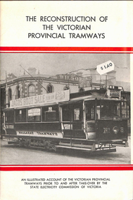 Melbourne Tram Museum
Book, Bob Prentice, "The Reconstruction of The Victorian Provincial Tramways", 1976
Sixteen page book plus card covers titled "The Reconstruction of The Victorian Provincial Tramways", an illustrated account of the Victorian provincial tramways prior to and after take-over by the State Electricity Commission of Victoria and the work done to rehabilitate them for further service. Compiled by Bob Prentice, published by the Haddon Tramway Workshops 1976. Outlines the creation of the SEC, the takeover of the private companies by the SEC and the question who would run their tramways, the condition of the tramways at the time of the SEC takeover, reconstruction work and maps of Geelong, Ballarat and Bendigo. Has a line drawing of Geelong No. 4 on title page.Has a $2.50 sticker in the top right hand corner.trams, tramways, ballarat, bendigo, geelong, secv, reconstruction, maps