Showing 4324 items
matching form photograph
-
 Eltham District Historical Society Inc
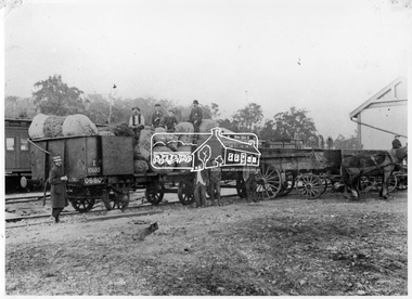
Photograph, Loading fruit trees at Hurstbridge Railway Station, 1914
Allwood Nurseries in Hurstbridge was operated by W.G (William George) Gray. He operated a well cultivated property under nursery healthy stock, principally apples, peaches, plums and cherries and sometimes potatoes. He grew seedling stock which he supplied to other local orchardists and the overseas market. This image is of railroad train wagons loaded with fruit trees at Hurstbridge Railway Station for export to New Zealand. Frederick George Hurst (bearded) sits on top of the load (aged 73 years). His son-in-law Willian Gray stands beside the wagon. This photo forms part of a collection of photographs gathered by the Shire of Eltham for their centenary project book, "Pioneers and Painters: 100 years of the Shire of Eltham" by Alan Marshall (1971). The collection of over 500 images is held in partnership between Eltham District Historical Society and Yarra Plenty Regional Library (Eltham Library) and is now formally known as 'The Shire of Eltham Pioneers Photograph Collection.' It is significant in being the first community sourced collection representing the places and people of the Shire's first one hundred years.Digital imagesepp, shire of eltham pioneers photograph collection, hurstbridge, allwood nurseries, frederick george hurst, w.g. gray, hurstbrdge railway station, william george gray, railroad trains, nurseries (plants), export, despatch, transport -
 Eltham District Historical Society Inc
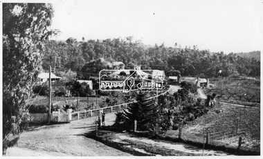
Photograph, Allwood, Hurstbridge, 1920
View of Allwood at Hurstbridge with Clarice and Sheila Gray at the front gate. View from Dorset House.This photo forms part of a collection of photographs gathered by the Shire of Eltham for their centenary project book, "Pioneers and Painters: 100 years of the Shire of Eltham" by Alan Marshall (1971). The collection of over 500 images is held in partnership between Eltham District Historical Society and Yarra Plenty Regional Library (Eltham Library) and is now formally known as 'The Shire of Eltham Pioneers Photograph Collection.' It is significant in being the first community sourced collection representing the places and people of the Shire's first one hundred years.Digital imagesepp, shire of eltham pioneers photograph collection, hurstbridge, allwood house, clarice gray, sheila gray -
 Eltham District Historical Society Inc
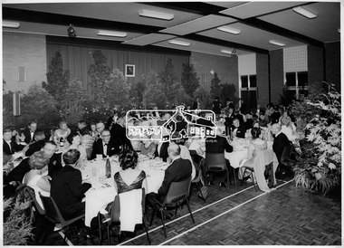
Photograph, Shire of Eltham Centenary Dinner, 6 Apr 1971
Guests seated at the Shire of Eltham Centenary Dinner in 1971. The tables dressed in white tablecoths surrounded by a display of greenery. The event was held in the West Riding Hall, Petrie Park Community Centre, Montmorency. This photo forms part of a collection of photographs gathered by the Shire of Eltham for their centenary project book, "Pioneers and Painters: 100 years of the Shire of Eltham" by Alan Marshall (1971). The collection of over 500 images is held in partnership between Eltham District Historical Society and Yarra Plenty Regional Library (Eltham Library) and is now formally known as 'The Shire of Eltham Pioneers Photograph Collection.' It is significant in being the first community sourced collection representing the places and people of the Shire's first one hundred years.Digital imagesepp, shire of eltham pioneers photograph collection, shire of eltham, shire of eltham centenary, official dinner, centenary celebrations, petrie park community centre montmorency -
 Eltham District Historical Society Inc
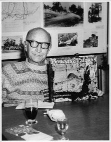
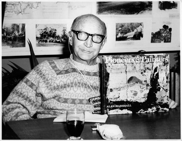
Photograph, Book launch "Pioneers & Painters"; Mr. Alan Marshall, 13 Park Road, Eltham. Editor of "Pioneers and Painters", 7 Jul 1971
Local writer and resident, Alan Marshall, author of "Pioneers and Painters: One Hundred years of Eltham and its Shire". The history was commissioned by the Shire of Eltham and published as part of the Shire of Eltham centenary celebrations. This photo was taken at the launch of the book. This photo forms part of a collection of photographs gathered by the Shire of Eltham for their centenary project book, "Pioneers and Painters: 100 years of the Shire of Eltham" by Alan Marshall (1971). The collection of over 500 images is held in partnership between Eltham District Historical Society and Yarra Plenty Regional Library (Eltham Library) and is now formally known as 'The Shire of Eltham Pioneers Photograph Collection.' It is significant in being the first community sourced collection representing the places and people of the Shire's first one hundred years.Digital imagesepp, shire of eltham pioneers photograph collection, shire of eltham, shire of eltham centenary, pioneers and painters, book launch, alan marshall -
 Eltham District Historical Society Inc
Photograph, Book launch "Pioneers & Painters"; Mr. Alan Marshall, 13 Park Road, Eltham. Editor of "Pioneers and Painters", 7 July 1971, 7 Jul 1971
Local writer and resident, Alan Marshall, author of "Pioneers and Painters: One Hundred years of Eltham and its Shire". The history was commissioned by the Shire of Eltham and published as part of the Shire of Eltham centenary celebrations. This photo was taken at the launch of the book. This photo forms part of a collection of photographs gathered by the Shire of Eltham for their centenary project book, "Pioneers and Painters: 100 years of the Shire of Eltham" by Alan Marshall (1971). The collection of over 500 images is held in partnership between Eltham District Historical Society and Yarra Plenty Regional Library (Eltham Library) and is now formally known as 'The Shire of Eltham Pioneers Photograph Collection.' It is significant in being the first community sourced collection representing the places and people of the Shire's first one hundred years.Digital imagesepp, shire of eltham pioneers photograph collection, shire of eltham, shire of eltham centenary, pioneers and painters, book launch, alan marshall -
 Eltham District Historical Society Inc
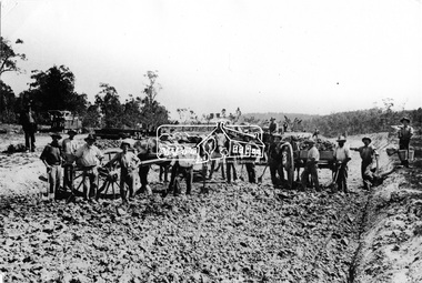
Photograph, Excavating Railway Cutting to Hurstbridge
Labourers excavate a cutting for the new railiway extension from Eltham to Hurstbridge. Men are working with shovels and buckets, dropping dirt into horse and carts. A pile of newly cut sleepers sit on the sidelines waiting to be laid. The new extension is approx. seven miles in length and opened on 2 January, 1912.This photo forms part of a collection of photographs gathered by the Shire of Eltham for their centenary project book, "Pioneers and Painters: 100 years of the Shire of Eltham" by Alan Marshall (1971). The collection of over 500 images is held in partnership between Eltham District Historical Society and Yarra Plenty Regional Library (Eltham Library) and is now formally known as 'The Shire of Eltham Pioneers Photograph Collection.' It is significant in being the first community sourced collection representing the places and people of the Shire's first one hundred years.Digital imagesepp, shire of eltham pioneers photograph collection, diamond creek, hurstbridge, wattle glen, railway line construction, railroad construction workers, railroad construction -
 Eltham District Historical Society Inc
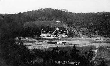
Photograph, Hurstbridge - Showing Railway Station
View overlooking the township and surrounding hills of Hurstbridge. The new railway line and station and accompanying works are central. The extension from Eltham to Hurstbridge opened on 2 January 1912.This photo forms part of a collection of photographs gathered by the Shire of Eltham for their centenary project book, "Pioneers and Painters: 100 years of the Shire of Eltham" by Alan Marshall (1971). The collection of over 500 images is held in partnership between Eltham District Historical Society and Yarra Plenty Regional Library (Eltham Library) and is now formally known as 'The Shire of Eltham Pioneers Photograph Collection.' It is significant in being the first community sourced collection representing the places and people of the Shire's first one hundred years.Digital imagesepp, shire of eltham pioneers photograph collection, diamond creek, hurstbridge, railway station, railroad, railway line -
 Eltham District Historical Society Inc
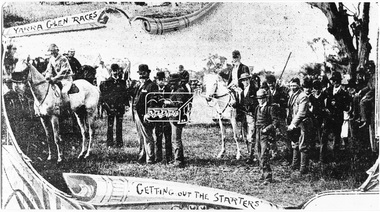
Photograph, Yarra Glen Races "Getting out the Starters" (reproduced from "The Leader", Jan. 6th, 1894, page 31)
Source: Mrs. E.W. Motschall (nee Marjorie Smith), Long Gully Road, Panton HillThis photo forms part of a collection of photographs gathered by the Shire of Eltham for their centenary project book,"Pioneers and Painters: 100 years of the Shire of Eltham" by Alan Marshall (1971). The collection of over 500 images is held in partnership between Eltham District Historical Society and Yarra Plenty Regional Library (Eltham Library) and is now formally known as the 'The Shire of Eltham Pioneers Photograph Collection.' It is significant in being the first community sourced collection representing the places and people of the Shire's first one hundred years.Digital imagesepp, shire of eltham pioneers photograph collection, yarra glen, cave hill, steels creek, yarra glen races -
 Eltham District Historical Society Inc
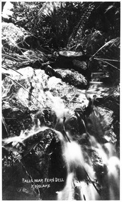
Photograph, Kinglake National Park, falls near Fern Dell, Kinglake, c.1918
Source: Mrs. McMinn, Kinglake.This photo forms part of a collection of photographs gathered by the Shire of Eltham for their centenary project book,"Pioneers and Painters: 100 years of the Shire of Eltham" by Alan Marshall (1971). The collection of over 500 images is held in partnership between Eltham District Historical Society and Yarra Plenty Regional Library (Eltham Library) and is now formally known as the 'The Shire of Eltham Pioneers Photograph Collection.' It is significant in being the first community sourced collection representing the places and people of the Shire's first one hundred years.Digital imagesepp, shire of eltham pioneers photograph collection, kinglake, kinglake national park, water falls -
 Eltham District Historical Society Inc
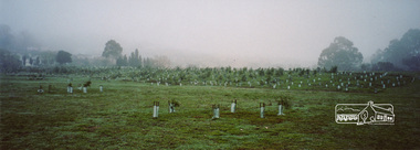
Photograph, Barak Bushlands Reserve, Eltham, March 2003, 2003
This area is urban and wetlands west of the Eltham gateway approach near the bridge over Diamond Creek and forms part of a walking trail. On 15 August 2004, the Shire of Nillumbik officially named the area "Barak Bushlands" as part of its commitment to Aboriginal reconciliation. The naming day memorialised the one hundred and first anniversary of the death of the last full-blood Yarra Aboriginal leader, William Barak. Source: Aboriginal reconcilation events in Nillumbik, Ken Eckersall, 2006.Digital scan from borrowed photobarak bushlands reserve, eltham, walking trail -
 Eltham District Historical Society Inc
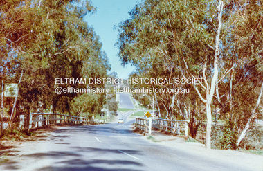
Photograph, Wattletree Road Bridge, Eltham, c. August 1977, 1977
Traffic island at intersection is lined with white-painted bluestone edging which originally was part of the Eltham lock-up situated at 728 Main Road. The bluestone has since been re-used (from late 1980s) at the rear of 728 Main Road to form the garden bed in car park. Colour photographeltham, infrastructure, main road, shire of eltham infrastructure, wattletree road bridge, bridge -
 Eltham District Historical Society Inc
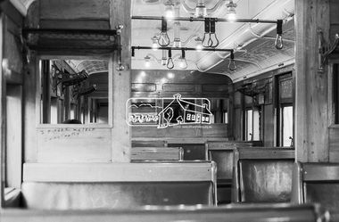
Photograph, George Coop, Interior of a Red Rattler Tait train passenger carriage, 22 August 1983, 1983
Note the graffiti. Older 20th.c and earlier railway cars were rolling palaces of the cabinet makers art. Full of polished timber, plated & embossed metal fittings, soft upholstery & beveled glass. In their earliest form, the Tait’s and earlier swing door cars for even modest suburban work, reflected some level of this design approach. Plus of course large sepia toned photographs on dividing walls displaying tourist spots trains could take you to.Digital TIFF file Scan of 35mm Kodak Safety 5062 black and white transparencygraffiti, interior, passenger carriage, red rattler, tait train -
 Glen Eira Historical Society
Album - Album page, Heatherbrae, 73 Neerim Road, Circa 1972
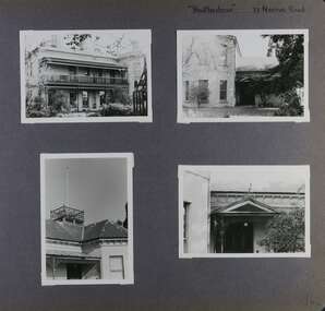
This photograph is part of the Caulfield Historical Album 1972. This album was created in approximately 1972 as part of a project by the Caulfield Historical Society to assist in identifying buildings worthy of preservation. The album is related to a Survey the Caulfield Historical Society developed in collaboration with the National Trust of Australia (Victoria) and Caulfield City Council to identify historic buildings within the City of Caulfield that warranted the protection of a National Trust Classification. Principal photographer thought to be Trevor Hart, member of Caulfield Historical Society. Most photographs were taken between 1966-1972 with a small number of photographs being older and from unknown sources. All photographs are black and white except where stated, with 386 photographs over 198 pages.From Victorian Heritage Database citation for Heatherbrae HO46 https://vhd.heritagecouncil.vic.gov.au/places/120933 (as at 28/10/2020) "Heatherbrae" at 73 Neerim Road, Glenhuntly, is a substantial Victorian residential complex made up of two principal construction stages (pre 1876 and c. 1890) and outbuildings including stables. It is aesthetically, historically and socially significant. Its aesthetic value is demonstrated by the manner in which the two periods of construction survive, the earliest being of greater architectural interest on account of its tower and facade treatment, the latter phase adopting a common villa form. The importance of the complex is heightened by its intact state and surviving outbuildings. "Heatherbrae's" historical significance lies in its link with locally known business man and Shire of Caulfield councillor, John Charles Holland. Its social value rests on its ability to demonstrate a past lifestyle.Page 142 of Photograph Album with four photographs (three landscape, one portrait) of Heatherbrae on Neerim Road.Handwritten: "Heatherbrae" 73 Neerim Road [top right] / 142 [bottom right]trevor hart, verandah, chimneys, decorative brackets, cast iron columns, return verandah, garden, 1870's, intricate lacework, neerim road, booran road, 1880's, 1890's, mansion, john c. holland, bluestone foundations, italianate, iron roofed balcony, cast iron balustrade, balcony, ornamented pediment, mosaic tiles, cast iron lookout, flagpole, george f griffiths, mcgowan, tower, caulfield, heatherbrae, cast iron work, victorian style, john holland, porte-cochere porches, lead lights, george griffiths, mansions, stables, councillors, outbuildings -
 Glen Eira Historical Society
Album - Album page, Heatherbrae, 73 Neerim Road, Circa 1972
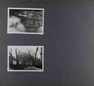
This photograph is part of the Caulfield Historical Album 1972. This album was created in approximately 1972 as part of a project by the Caulfield Historical Society to assist in identifying buildings worthy of preservation. The album is related to a Survey the Caulfield Historical Society developed in collaboration with the National Trust of Australia (Victoria) and Caulfield City Council to identify historic buildings within the City of Caulfield that warranted the protection of a National Trust Classification. Principal photographer thought to be Trevor Hart, member of Caulfield Historical Society. Most photographs were taken between 1966-1972 with a small number of photographs being older and from unknown sources. All photographs are black and white except where stated, with 386 photographs over 198 pages.From Victorian Heritage Database citation for Heatherbrae HO46 https://vhd.heritagecouncil.vic.gov.au/places/120933 as at (28/10/2020) "Heatherbrae" at 73 Neerim Road, Glenhuntly, is a substantial Victorian residential complex made up of two principal construction stages (pre 1876 and c. 1890) and outbuildings including stables. It is aesthetically, historically and socially significant. Its aesthetic value is demonstrated by the manner in which the two periods of construction survive, the earliest being of greater architectural interest on account of its tower and facade treatment, the latter phase adopting a common villa form. The importance of the complex is heightened by its intact state and surviving outbuildings. "Heatherbrae's" historical significance lies in its link with locally known business man and Shire of Caulfield councillor, John Charles Holland. Its social value rests on its ability to demonstrate a past lifestyle. Page 143 of Photograph Album with 2 landscape photographs of Heatherbrae on Neerim Road - paving insignia and side view.Handwritten: "HEATHERBRAE" 73 NEERIM ROAD [top] / STABLE [under bottom photo] / 143 [bottom left]trevor hart, chimneys, cast iron columns, return verandah, garden, 1870's, neerim road, booran road, 1880's, 1890's, mansion, john c. holland, bluestone foundations, italianate, iron roofed balcony, cast iron balustrade, mosaic tiles, cast iron lookout, flagpole, george f griffiths, residential villa, caulfield, heatherbrae, victorian style, cast iron work, stables, outbuildings, john holland, george griffiths, councillors, mansions -
 Glen Eira Historical Society
Album - Album page, Neerim Road, Circa 1972
This photograph is part of the Caulfield Historical Album 1972. This album was created in approximately 1972 as part of a project by the Caulfield Historical Society to assist in identifying buildings worthy of preservation. The album is related to a Survey the Caulfield Historical Society developed in collaboration with the National Trust of Australia (Victoria) and Caulfield City Council to identify historic buildings within the City of Caulfield that warranted the protection of a National Trust Classification. Principal photographer thought to be Trevor Hart, member of Caulfield Historical Society. Most photographs were taken between 1966-1972 with a small number of photographs being older and from unknown sources. All photographs are black and white except where stated, with 386 photographs over 198 pages. "Edenkillie" was the home of Frederick Jowett, Caulfield's shire secretary and town clerk from 1887 to 1921. The Outer Circle Railway's Oakleigh section opened 1890 and closed 1895. Victorian Heritage database (as of 26/10/2021) HO45 Edenkillie https://vhd.heritagecouncil.vic.gov.au/places/35545 "Edenkillie" at 37 Neerim Road, Glenhuntly, is a substantial two storeyed polychrome brick villa, built for Frederick Jowett, municipal secretary, in 1890. It has aesthetic, historical and social significance. "Edenkillie's" aesthetic value derives from its survival as a substantially intact example of a common villa form expressed in polychrome brickwork. Its historical significance lies in its association with Frederick Jowett, Shire of Caulfield secretary and town clerk for over three decades. Its social significance is derived from the building's ability to demonstrate the kind of lifestyle which a local government administrator could enjoy during the Land Boom.Page 145 of Photograph Album with four landscape photographs from Neerim Road: two photographs of No 37 and two of the Outer Circle Railway Reserve.Handwritten: Neerim Road [top left] / 37 NEERIM ROAD 1OCT 1972 [under top left photo] / 37 NEERIM RD 1 OCT 1972 [under top right photo] / OUTER CIRCLE RAILWAY RESERVE MURRUMBEENA [under bottom left photo] / 145 [bottom left]trevor hart, neerim road, murrumbeena, caulfield, edenkillie, glen huntly, polychrome brick, mansions, frederick jowett, town clerks, shire of caulfield, outer circle railway, railways, parks and reserves, outer circle railway reserve, cast iron work, verandahs, balconies -
 Glen Eira Historical Society
Album - Album page, Normanby Road, Circa 1972
This photograph is part of the Caulfield Historical Album 1972. This album was created in approximately 1972 as part of a project by the Caulfield Historical Society to assist in identifying buildings worthy of preservation. The album is related to a Survey the Caulfield Historical Society developed in collaboration with the National Trust of Australia (Victoria) and Caulfield City Council to identify historic buildings within the City of Caulfield that warranted the protection of a National Trust Classification. Principal photographer thought to be Trevor Hart, member of Caulfield Historical Society. Most photographs were taken between 1966-1972 with a small number of photographs being older and from unknown sources. All photographs are black and white except where stated, with 386 photographs over 198 pages. From: Glen Eira Heritage Management Plan (1996) - Vol 2 by Andrew Ward and Associates The widening of Dandenong Road during the late 1980's has resulted in the destruction of the houses in the path of the roadworks and the construction of a high fence serving as a visual barrier between that thoroughfare and the remaining houses. Where comparatively large villas once stood on spacious allotments, only "Wisteria" survives at No. 135 Normanby Road. Adopting forms and timber enrichment characteristic of the American Queen Anne style, it has this in common with the largely reconstructed timber villa at no. 11 Normanby Avenue and to a lesser extent, 746 Inkerman Road. Normanby Road retains its comparatively opulent Edwardian character in a mature landscaped setting with spacious gardens and mature planes parallel with the railway reserve which, on account of the low lying ground in its vicinity has a high embankment commencing on the alignment of Malvern Grove and continuing to Caulfield Station. The earliest villas are Edwardian. Page 148 of Photograph Album with one landscape photograph of a house on Normanby Road (not Street).Handwritten: Normanby St [top right] / 148 [bottom right]trevor hart, verandah, porch, bull nosed verandah, tower house, tower, stone fence, normanby road, wisteria, american queen anne style, queen anne style, 1890's, mayfield grove, normanby street, timber houses, caulfield north, house names, edwardian, edwardian style, gardens -
 Glen Eira Historical Society
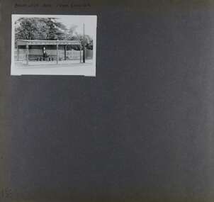
Album - Album page, Balaclava Road Tram Shelter, Circa 1972
This photograph is part of the Caulfield Historical Album 1972. This album was created in approximately 1972 as part of a project by the Caulfield Historical Society to assist in identifying buildings worthy of preservation. The album is related to a Survey the Caulfield Historical Society developed in collaboration with the National Trust of Australia (Victoria) and Caulfield City Council to identify historic buildings within the City of Caulfield that warranted the protection of a National Trust Classification. Principal photographer thought to be Trevor Hart, member of Caulfield Historical Society. Most photographs were taken between 1966-1972 with a small number of photographs being older and from unknown sources. All photographs are black and white except where stated, with 386 photographs over 198 pages. From Victorian Heritage Database citation H0174 TRAM VERANDAH SHELTER CORNER BALACLAVA AND ORRONG ROADS CAULFIELD NORTH - Vic Heritage Register https://vhd.heritagecouncil.vic.gov.au/places/2721 (as at 28/10/2020) The waiting shelter at the corner of Balaclava Road and Orrong Road, Caulfield was constructed in 1916/17 for the Prahran and Malvern Tramways Trust and is one of only three remaining tram shelters in Melbourne designed in the form of a verandah. The shelter has a corrugated iron roof fixed to an angle iron roof frame. The roof, which extends in the form of a skillion over the pavement, is supported on three squared, chamfered timber posts at the rear and three cast iron reeded columns with round bases and Corinthian capitals at the front. (The columns are hollow and function as downpipes, with rainwater discharging from the verandah roof, through the columns and under the ground). The shelter has a rinceau pattern frieze along the road frontage with centrally placed shield motif (which does not contain a coat of arms). The side and rear panels are lined with ripple iron and the upper panel at the rear is lattice work. The shelter has two timber slatted bench seats.From Victorian Heritage Database citation for H0174 TRAM VERANDAH SHELTER CORNER BALACLAVA AND ORRONG ROADS CAULFIELD NORTH - Vic Heritage Register https://vhd.heritagecouncil.vic.gov.au/places/2721 (as at 28/10/2020) How is it significant? The waiting shelter at the corner of Balaclava Road and Orrong Road, Caulfield is of historical and architectural significance to the State of Victoria. Why is it significant? The waiting shelter is of historical significance for its association with the development of the suburban (electric) tram network which assisted the expansion of Melbourne as a suburban metropolis. It is also of historical significance for its connection with the Prahran & Malvern Tramways Trust. The Prahran & Malvern Tramways Trust (1907-1920) was the first municipal electric tramway in Melbourne, becoming the largest and most successful of all the municipal tramway trusts. Its services played a key role in facilitating suburban expansion and the development of the southern and eastern suburbs. The growth of tramways was one of the greatest municipal developments in Victoria during the first decade of the twentieth century. The waiting shelter is an important remnant of this period of Melbourne's transport history and a tangible reminder of the Prahran & Malvern Tramways Trust. The shelter indicates the extent of the Prahran & Malvern tram network. The waiting shelter at corner of Balaclava Road and Orrong Road, Caulfield is one of only three remaining tram shelters in Melbourne designed in the form of a verandah. The waiting shelter is of architectural significance for the distinctive design and construction which is unique to the Prahran & Malvern Tramway Trust tram network. The shelter was designed by notable Melbourne architect Leonard J. Flannagan (1864-1946). Flannagan was responsible for a number of buildings for the Prahran and Malvern Tramways Trust including the early waiting shelter at the junction of Dandenong Road and Hawthorn Road, Caulfield, and sections of the tram depot at Malvern, and also designed a depot for the Hawthorn Tramways Trust. The waiting shelter, a conservative design influenced by Victorian architecture, is based on the Melbourne City Council late 19th century standard cast iron verandah. It is of significance as an intact example of the cast iron type shelter and for its detail, including Corinthian columns and a 'rinceau' pattern cast-iron frieze. The shelter is largely in keeping with the original design and retains its integrity. The cast iron waiting shelter is also of significance as an unusual example of early twentieth century street architecture. Page 155 of Photograph Album with one landscape photograph of a tram shelter on Balaclava Road.Handwritten: BALACLAVA ROAD TRAM SHELTER [top] / 155 [bottom left]trevor hart, verandah, garden, grimwade house, grimwade, orrong road, balaclava road, melbourne grammar, melbourne grammar junior school, mgs, m.g.s, school, tram shelter, waiting shelter, prahran & malvern tramway trust, leonard j. flannagan, cast iron verandah, cast iron type shelter, corinthian columns, 'rinceau' pattern cast-iron frieze, rinceau, cast iron frieze, victorian style, caulfield north, leonard flanagan, cast iron work, prahran and malvern tramways trust, trams -
 Glen Eira Historical Society
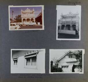
Album - Album page, Orrong Road, Circa 1972
This photograph is part of the Caulfield Historical Album 1972. This album was created in approximately 1972 as part of a project by the Caulfield Historical Society to assist in identifying buildings worthy of preservation. The album is related to a Survey the Caulfield Historical Society developed in collaboration with the National Trust of Australia (Victoria) and Caulfield City Council to identify historic buildings within the City of Caulfield that warranted the protection of a National Trust Classification. Principal photographer thought to be Trevor Hart, member of Caulfield Historical Society. Most photographs were taken between 1966-1972 with a small number of photographs being older and from unknown sources. All photographs are black and white except where stated, with 386 photographs over 198 pages.Victorian Heritage Database https://vhd.heritagecouncil.vic.gov.au/places/35576 No. 70 Orrong Road is important as an exceptionally ornate Boom style villa residence in the terraced form and in this respect is rare in Caulfield. Its architectural value is enhanced by its intact state and by the manner in which its bold architectural expression is carried through into the hallway and staircase. Victorian Heritage Database - National Trust local significance 284 Orrong Road Caulfield https://vhd.heritagecouncil.vic.gov.au/places/65700 A house designed by Harold Desbrowe Annear in 1917 and believed to have been the first "all electric" house in Melbourne. It has been extensively altered.Page 164 - four photographs of 2 different houses on Orrong Road. The top left photo is in colour while the others are in black and white.Handwritten: Orrong Road [top right] / Lisborn House [ (ed. correct name is LISBON HOUSE), under top left photo] / Lisborn House [under top right photo] / [under bottom right photo] / CORNER ORRONG ROAD AND PEARSON AVENUE / HOUSE BY DESBROWE ANNEAR [under bottom left photo] / 164 [bottom right]trevor hart, orrong road, lisbon house, lisborn house, elsternwick, pearson grove, st kilda east, caulfield north, terrace houses, cast iron work, verandahs, balconies, parapets, arches, cars, streetscapes, attic houses, desbrowe annear -
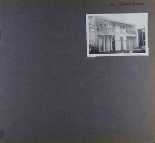 Glen Eira Historical Society
Album - Album page, 32 Queen's Avenue, Circa 1972
This photograph is part of the Caulfield Historical Album 1972. This album was created in approximately 1972 as part of a project by the Caulfield Historical Society to assist in identifying buildings worthy of preservation. The album is related to a Survey the Caulfield Historical Society developed in collaboration with the National Trust of Australia (Victoria) and Caulfield City Council to identify historic buildings within the City of Caulfield that warranted the protection of a National Trust Classification. Principal photographer thought to be Trevor Hart, member of Caulfield Historical Society. Most photographs were taken between 1966-1972 with a small number of photographs being older and from unknown sources. All photographs are black and white except where stated, with 386 photographs over 198 pages. From Victorian Heritage Database citation for HO137 32 Queens Ave, Caulfield East https://vhd.heritagecouncil.vic.gov.au/places/35536 as at (30/10/2020) The house at no. 32 Queens Avenue, Carnegie, was built in 1888 and formed one of an identical pair since demolished. It was built for and formed part of a land development scheme undertaken by one of Sir Matthew Davies group of speculative companies known as the Freehold Investment and Banking Company of Australia Ltd. It is historically and aesthetically important. It is aesthetically important (Criterion E) as an unusual terraced building form in Glen Eira that stands apart from its neighbours which were built predominantly after the tum of the twentieth century and which is further distinguished by the cast cement ornamentation applied to the central porch.Page 168 of Photograph Album with one photograph of a house on Queen's Avenue. Handwritten: 32 Queen's Avenue [top right] / 168 [bottom right]trevor hart, cast iron lacework, decorative brackets, chimneys, verandah, porch, cast iron columns, queens avenue, 1880's, sir matthew davies, matthew davies, freehold investment and banking company of australia ltd, cast cement ornamentation, arches, caulfield racecourse, portico, stone columns, full length french windows, fanlight, caulfield, race course, queen's avenue, caulfield east, land subdivision, victorian style, cast iron work, rendered mansions, lead lights, terraced buildings -
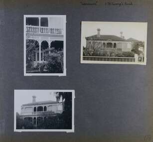 Glen Eira Historical Society
Album - Album page, Glenmoore, St George's Road, Circa 1972
This photograph is part of the Caulfield Historical Album 1972. This album was created in approximately 1972 as part of a project by the Caulfield Historical Society to assist in identifying buildings worthy of preservation. The album is related to a Survey the Caulfield Historical Society developed in collaboration with the National Trust of Australia (Victoria) and Caulfield City Council to identify historic buildings within the City of Caulfield that warranted the protection of a National Trust Classification. Principal photographer thought to be Trevor Hart, member of Caulfield Historical Society. Most photographs were taken between 1966-1972 with a small number of photographs being older and from unknown sources. All photographs are black and white except where stated, with 386 photographs over 198 pages. From Victorian Heritage Database citation for HO59 Glenmoore, 1 St Georges Road Elsternwick https://vhd.heritagecouncil.vic.gov.au/places/35202 as at 30/10/2020 "Glenmoore" is locally significant as a surviving mid nineteenth century villa residence in the then fashionable bi-chromatic brick form. It is also important as the home of Hugh Moore who built several shops in nearby Glen Huntly Road and which remain as important contributors to the architectural character of the Elsternwick Shopping Centre.Victorian Heritage Database citation HO59 Glenmoore, 1 St Georges Road Elsternwick https://vhd.heritagecouncil.vic.gov.au/places/35202 An imposing two storeyed villa in bichrome brick with two storeyed timber posted verandah, coupled with cast iron lace frieze, spandrels and central tympanum enrichment. The hipped roof is in slate and has a prominent crean1 brick chimney stack forming part of the facade. Openings are flat arched although the entrance is round arched with a fan light. The south elevation has bayed windows. Two storeyed hip roofed additions are sympathetic and attached on the north side and at the rear. Inside, the staircase and stained glasswork with initials "HM" and family coat of arms are important surviving elements. INTEGRITY: Good, timber outbuildings of an early date, mature and spacious front garden includes early palm trees. Alterations include reconstruction of facade verandah including tiled pavement and front door on east side. Interior has a high level of integrity. Original grounds included adjoining "Carramar".Page 178 of Photograph Album with three photographs of Glenmoore, St Georges Road. Handwritten: "Glenmoore" 1 St George's Road [top right] / 178 [bottom right]trevor hart, chimneys, porch, mansion, slate roof, return verandah, stained glass, cast iron frieze, glenmoore, 1860's, hugh moore, glenmoore estate, double storey, elsternwick shops, st george's road, thomas watts, elsternwick, victorian style, protruding bay windows, cast iron work, bi-chromatic bricks, gardens, balconies, moore's buildings, glen huntly road, stairs, house names -
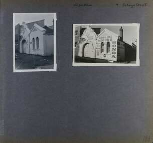 Glen Eira Historical Society
Album - Album page, Old Fire Station, 4 Selwyn Street, Circa 1972
This album was created in approximately 1972 as part of a project by the Caulfield Historical Society to assist in identifying buildings worthy of preservation. The album is related to a Survey the Caulfield Historical Society developed in collaboration with the National Trust of Australia (Victoria) and Caulfield City Council to identify historic buildings within the City of Caulfield that warranted the protection of a National Trust Classification. Principal photographer thought to be Trevor Hart, member of Caulfield Historical Society. Most photographs were taken between 1966-1972 with a small number of photographs being older and from unknown sources. All photographs are black and white except where stated, with 386 photographs over 198 pages. From Victorian Heritage Database citation for H2376 Former Elsternwick Fire Station, 2-4 Selwyn Street Elsternwick - Victorian Heritage Register https://vhd.heritagecouncil.vic.gov.au/places/2645 (as at 21/11/2021) The Former Elsternwick Fire Station was built and commenced operation in 1896. It was one of 32 new fire stations built between 1892 and 1896 by the newly formed Melbourne Metropolitan Fire Brigade ('MFB') to form a comprehensive fire-fighting network across Melbourne. The MFB was established in 1891 as Victoria's government-run fire-fighting service in Melbourne and its growing suburbs. By 1918 motorised fire engine appliances had replaced horse-drawn fire vehicles across the metropolitan area, and the consequently larger areas that fire stations could protect meant the 1896 Elsternwick Fire Station was one of many which was becoming obsolete. The MFB continued to use the Elsternwick Fire Station up until the Station's closure in 1926. From 1927 the former Fire Station was leased by neighbouring timber merchants JJ Webster Pty Ltd who subsequently purchased the property from the MFB in 1934. From 1954 the 'Esquire Motors' car repair business traded at the site, and changes to the former Fire Station building including the complete enclosure of its yard by corrugated steel walls and roofing appear to have been completed in the mid-1950s. In 1990 the Australian Broadcasting Corporation ('ABC') purchased the former Fire Station together with five other adjoining land parcels in Selwyn Street. From that time until 2017 the former Elsternwick Fire Station has been used by the ABC as office and storage space in its Selwyn Street television studio complex.From Victorian Heritage Database citation for H2376 Former Elsternwick Fire Station, 2-4 Selwyn Street Elsternwick - Victorian Heritage Register https://vhd.heritagecouncil.vic.gov.au/places/2645 (as at 21/11/2021) The Former Elsternwick Fire Station is historically significant as one of the 10 remaining fire stations of the original 32 built for the newly established Melbourne Metropolitan Fire Brigade ('MFB') during the four-year period 1892 to 1896. These fire stations were constructed following the establishment in 1891 of the MFB, Victoria's government-run fire-fighting service for metropolitan Melbourne and its growing suburban population. These new stations formed a crucial part of the MFB's fire-fighting network across Melbourne. The Former Elsternwick Fire Station clearly demonstrates the historical development of fire-fighting services in Melbourne, especially the expansion of the newly-formed MFB throughout Melbourne's suburbs during the 1890s. [Criterion A] The Former Elsternwick Fire Station is architecturally significant as a fine example of a late nineteenth century fire station. Constructed shortly after the establishment of the MFB, it displays characteristics of its class of place that remain mostly unchanged from the former Station's historically important period of development and use. A particularly strong element of the Former Elsternwick Fire Station is the large and strikingly-detailed stone horseshoe arch, designed for horse-drawn fire-fighting vehicles, at the street entrance to its fire-engine room. [Criterion D]Page 188 of Photograph Album with two photographs of the old Elsternwick Fire Station.Handwritten: old fire station 4 Selwyn Street [top right] / 188 [bottom right]trevor hart, rendered, 1890's, melbourne metropolitan fire brigade, mfb, fire-fighting, jj webster, timber merchants, esquire motors, car repair, australian broadcasting corporation, abc, selwyn street, brick and stone, asymmetrical facade, anglo-dutch gable, rusticated and smooth-faced limestone, elsternwick fire station, elsternwick, fire station, jj webster pty ltd, motor vehicle repair shops, stone horseshoe arch entrance -
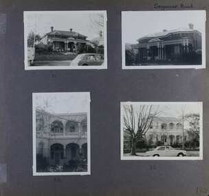 Glen Eira Historical Society
Album - Album page, Seymour Road, Circa 1972
This album was created in approximately 1972 as part of a project by the Caulfield Historical Society to assist in identifying buildings worthy of preservation. The album is related to a Survey the Caulfield Historical Society developed in collaboration with the National Trust of Australia (Victoria) and Caulfield City Council to identify historic buildings within the City of Caulfield that warranted the protection of a National Trust Classification. Principal photographer thought to be Trevor Hart, member of Caulfield Historical Society. Most photographs were taken between 1966-1972 with a small number of photographs being older and from unknown sources. All photographs are black and white except where stated, with 386 photographs over 198 pages. As at 22/08/2021, 51 Seymour Road is included in the HO179 Beemery Park Precinct which C204glen Amendment seeks to add to the Glen Eira Planning Scheme (amongst others). This is not yet finalised. Bellecourt (so named in 1989 according to Andrew Ward's Heritage Study) was originally named Beemery.Victorian Heritage Database HO62 Bellecourt 85 Seymour Road ELSTERNWICK https://vhd.heritagecouncil.vic.gov.au/places/35585 (as of 22/08/2021) "Beemery" at 85 Seymour Road, is an imposing ltalianate villa with arcaded asymmetrical facade built in 1891 for Charles Langdon. It has aesthetic, historical and social significance. Its aesthetic value rests with the facade which is highly representative of a not uncommon villa form of the late Victorian period. Its historical value derives from its association with the Langdon family in Caulfield (compare "Rosecraddock", "Tarqua" and "Hengar"). Its social value derives from its ability to demonstrate a lifestyle in late Victorian Caulfield.Page 190 of Photograph Album with four photographs of two different properties on Seymour Road.Handwritten: Seymour Road [top right] / 51 [under top left photo] / 51 [under top right photo] / 85 [under bottom left photo] / 85 [under bottom right photo] / 190 [bottom right]trevor hart, elsternwick, seymour road, late victorian, caulfield, beemery, bellecourt, house names, langdon family, charles langdon, cast iron work, verandahs, polychromatic brickwork, italianate style, arched balconies -
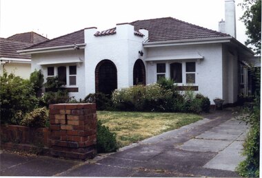
 Glen Eira Historical Society
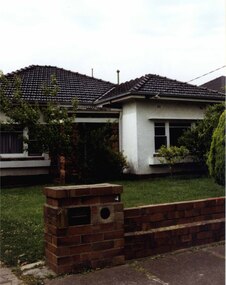
Photograph, Beauville Avenue, 1, Murrumbeena, 2001
Originally labelled "Beauville Estate, Established 1936, Still Thriving 65 years on, 10th March 2001", the Beauville Estate Album contains colour photographs of houses in the Estate. They were taken around the time of the Beauville Estate’s 65th Heritage Celebration held on 10/03/2001 and donated to the Caulfield Historical Society shortly afterwards. Photographer unknown. City of Glen Eira’s Heritage Management Plan Vol 2 p79 (this is p84 of the pdf version) – HO12 Beauville Estate and environs, Murrumbeena: The Beauville Historic Area is important at the State level as the first large housing estate undertaken by the AV Jennings Construction Co, later Jennings Group Limited, Victoria’s largest home builder. It is important also as a very early estate development incorporating a range of features other than houses and including made roads, shops and recreation facilities. In this respect it was the forerunner of the comprehensively planned housing estate of the post war era. The estate is distinguished by its aesthetic values, as is the earlier and comparable Hillcrest Estate, which are formed by a combination of restrained diversity in house styles, with the exception of no. 30 in the emerging International style, and by a landscaped garden environment. Colour photograph of white rendered house with unpainted brick features. Other features include a porch, tiled roof, window boxes and low unpainted brick fence in the foreground with "1" on the brick pillar beside the driveway.murrumbeena, houses, beauville avenue, architectural styles, 1930's, inter war style, a.v. jennings, av jennings, jennings, brick houses, beauville estate, porches, sir albert victor jennings, a v jennings construction co, beauville estate heritage area, glen eira city council, architectural features, housing estates, builders, jennings group limited, land subdivision, gardens, beauville historic area, brick fences -
 Glen Eira Historical Society
Album - Photograph Album, Beauville Estate Album, 2001
Originally labelled "Beauville Estate, Established 1936, Still Thriving 65 years on, 10th March 2001", the Beauville Estate Album contains colour photographs of houses in the Estate. They were taken around the time of the Beauville Estate’s 65th Heritage Celebration held on 10/03/2001 and donated to the Caulfield Historical Society shortly afterwards. Photographer unknown. Glen Eira’s Heritage Management Plan by Andrew Ward (1996) Vol 2 p78 states that by the end of 1934, the first 3 houses had been built in this housing estate.City of Glen Eira’s Heritage Management Plan Vol 2 p79 (p84 of the pdf version) – HO12 Beauville Estate and environs, Murrumbeena: The Beauville Historic Area is important at the State level as the first large housing estate undertaken by the AV Jennings Construction Co, later Jennings Group Limited, Victoria’s largest home builder. It is important also as a very early estate development incorporating a range of features other than houses and including made roads, shops and recreation facilities. In this respect it was the forerunner of the comprehensively planned housing estate of the post war era. The estate is distinguished by its aesthetic values, as is the earlier and comparable Hillcrest Estate, which are formed by a combination of restrained diversity in house styles, with the exception of no. 30 in the emerging International style, and by a landscaped garden environment.Colour photographs of house exteriors, as well as parks and tennis courts on the Beauville Estate. murrumbeena, houses, beauville avenue, architectural styles, 1930's, inter war style, a.v. jennings, av jennings, jennings, brick houses, beauville estate, murrumbeena road, lindsay avenue, gloucester court, dalny road, a v jennings construction co, beauville estate heritage area, glen eira city council, architectural features, plans, shops, residential development, tennis courts, housing estates, builders, building regulations, local government, commercial development, history, maps, photographs, commercial establishments, jennings group limited, land subdivision, gardens, beauville historic area, sir albert victor jennings -
 Glen Eira Historical Society
Photograph, Beauville Avenue, 2, Murrumbeena, 2001
Originally labelled "Beauville Estate, Established 1936, Still Thriving 65 years on, 10th March 2001", the Beauville Estate Album contains colour photographs of houses in the Estate. They were taken around the time of the Beauville Estate’s 65th Heritage Celebration held on 10/03/2001 and donated to the Caulfield Historical Society shortly afterwards. Photographer unknown. City of Glen Eira’s Heritage Management Plan Vol 2 p79 (this is p84 of the pdf version) – HO12 Beauville Estate and environs, Murrumbeena: The Beauville Historic Area is important at the State level as the first large housing estate undertaken by the AV Jennings Construction Co, later Jennings Group Limited, Victoria’s largest home builder. It is important also as a very early estate development incorporating a range of features other than houses and including made roads, shops and recreation facilities. In this respect it was the forerunner of the comprehensively planned housing estate of the post war era. The estate is distinguished by its aesthetic values, as is the earlier and comparable Hillcrest Estate, which are formed by a combination of restrained diversity in house styles, with the exception of no. 30 in the emerging International style, and by a landscaped garden environment. Colour photograph of an unpainted brick house. Other features include a central porch, tiled roof, square paned windows and a low unpainted brick fence in the foreground.murrumbeena, beauville avenue, architectural styles, 1930's, inter war style, a.v. jennings, av jennings, jennings, brick houses, beauville estate, porches, sir albert victor jennings, a v jennings construction co, beauville estate heritage area, glen eira city council, architectural features, jennings group limited, land subdivision, gardens, beauville historic area -
 Glen Eira Historical Society
Photograph, Beauville Avenue, 3, Murrumbeena, 2001
Originally labelled "Beauville Estate, Established 1936, Still Thriving 65 years on, 10th March 2001", the Beauville Estate Album contains colour photographs of houses in the Estate. They were taken around the time of the Beauville Estate’s 65th Heritage Celebration held on 10/03/2001 and donated to the Caulfield Historical Society shortly afterwards. Photographer unknown. City of Glen Eira’s Heritage Management Plan Vol 2 p79 (this is p84 of the pdf version) – HO12 Beauville Estate and environs, Murrumbeena: The Beauville Historic Area is important at the State level as the first large housing estate undertaken by the AV Jennings Construction Co, later Jennings Group Limited, Victoria’s largest home builder. It is important also as a very early estate development incorporating a range of features other than houses and including made roads, shops and recreation facilities. In this respect it was the forerunner of the comprehensively planned housing estate of the post war era. The estate is distinguished by its aesthetic values, as is the earlier and comparable Hillcrest Estate, which are formed by a combination of restrained diversity in house styles, with the exception of no. 30 in the emerging International style, and by a landscaped garden environment. Colour photograph of cream coloured rendered house with unpainted brick features. Other features include a semi circular porch, tiled roof, chimney and a low unpainted brick fence in the foreground with small shrubs behind. A concrete path crosses the lawn to the porch.murrumbeena, houses, beauville avenue, architectural styles, 1930's, inter war style, a.v. jennings, av jennings, jennings, brick houses, beauville estate, sir albert victor jennings, a v jennings construction co, beauville estate heritage area, glen eira city council, architectural features, jennings group limited, land subdivision, gardens, beauville historic area, porches, chimneys, brick fences -
 Glen Eira Historical Society
Photograph, Beauville Avenue, 4, Murrumbeena, 2001
Originally labelled "Beauville Estate, Established 1936, Still Thriving 65 years on, 10th March 2001", the Beauville Estate Album contains colour photographs of houses in the Estate. They were taken around the time of the Beauville Estate’s 65th Heritage Celebration held on 10/03/2001 and donated to the Caulfield Historical Society shortly afterwards. Photographer unknown. City of Glen Eira’s Heritage Management Plan Vol 2 p79 (this is p84 of the pdf version) – HO12 Beauville Estate and environs, Murrumbeena: The Beauville Historic Area is important at the State level as the first large housing estate undertaken by the AV Jennings Construction Co, later Jennings Group Limited, Victoria’s largest home builder. It is important also as a very early estate development incorporating a range of features other than houses and including made roads, shops and recreation facilities. In this respect it was the forerunner of the comprehensively planned housing estate of the post war era. The estate is distinguished by its aesthetic values, as is the earlier and comparable Hillcrest Estate, which are formed by a combination of restrained diversity in house styles, with the exception of no. 30 in the emerging International style, and by a landscaped garden environment. Colour photograph of a white rendered house with a few rows of unpainted bricks at ground level. Other features include black and white awnings, a concrete driveway leading to a garage with a car in front and 2 unpainted chimneys. A metal mail box has the number 4 painted on it in the foreground of the garden. The garden includes a large tree at the front. murrumbeena, houses, beauville avenue, architectural styles, 1930's, inter war style, a.v. jennings, av jennings, jennings, brick houses, beauville estate, porches, sir albert victor jennings, a v jennings construction co, beauville estate heritage area, glen eira city council, architectural features, jennings group limited, land subdivision, gardens, beauville historic area, garages (private), brick chimneys, rendered houses, drives, striped awnings -
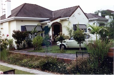 Glen Eira Historical Society
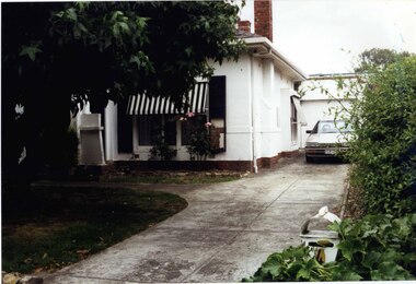
Photograph, Beauville Avenue, 5, Murrumbeena, 2001
Originally labelled "Beauville Estate, Established 1936, Still Thriving 65 years on, 10th March 2001", the Beauville Estate Album contains colour photographs of houses in the Estate. They were taken around the time of the Beauville Estate’s 65th Heritage Celebration held on 10/03/2001 and donated to the Caulfield Historical Society shortly afterwards. Photographer unknown. See also 2104A-06.City of Glen Eira’s Heritage Management Plan Vol 2 p79 (this is p84 of the pdf version) – HO12 Beauville Estate and environs, Murrumbeena: The Beauville Historic Area is important at the State level as the first large housing estate undertaken by the AV Jennings Construction Co, later Jennings Group Limited, Victoria’s largest home builder. It is important also as a very early estate development incorporating a range of features other than houses and including made roads, shops and recreation facilities. In this respect it was the forerunner of the comprehensively planned housing estate of the post war era. The estate is distinguished by its aesthetic values, as is the earlier and comparable Hillcrest Estate, which are formed by a combination of restrained diversity in house styles, with the exception of no. 30 in the emerging International style, and by a landscaped garden environment. Colour photograph of white rendered house with a car parked on the front lawn of the garden. Other features include an enclosed porch with unpainted brick edging with number "5" on the arched entrance, tiled roof, tall chimneys, striped black and white awnings and a low unpainted brick side fence beside the concrete driveway.murrumbeena, houses, beauville avenue, architectural styles, 1930's, inter war style, a.v. jennings, av jennings, jennings, brick houses, beauville estate, porches, sir albert victor jennings, a v jennings construction co, beauville estate heritage area, glen eira city council, architectural features, jennings group limited, land subdivision, gardens, beauville historic area, chimneys, rendered houses, drives, cars, brick fences, striped awnings -
 Glen Eira Historical Society
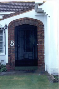
Photograph, Beauville Avenue, 5, Murrumbeena, 2001
Originally labelled "Beauville Estate, Established 1936, Still Thriving 65 years on, 10th March 2001", the Beauville Estate Album contains colour photographs of houses in the Estate. They were taken around the time of the Beauville Estate’s 65th Heritage Celebration held on 10/03/2001 and donated to the Caulfield Historical Society shortly afterwards. Photographer unknown. See also 2104A-05.City of Glen Eira’s Heritage Management Plan Vol 2 p79 (this is p84 of the pdf version) – HO12 Beauville Estate and environs, Murrumbeena: The Beauville Historic Area is important at the State level as the first large housing estate undertaken by the AV Jennings Construction Co, later Jennings Group Limited, Victoria’s largest home builder. It is important also as a very early estate development incorporating a range of features other than houses and including made roads, shops and recreation facilities. In this respect it was the forerunner of the comprehensively planned housing estate of the post war era. The estate is distinguished by its aesthetic values, as is the earlier and comparable Hillcrest Estate, which are formed by a combination of restrained diversity in house styles, with the exception of no. 30 in the emerging International style, and by a landscaped garden environment.Colour photograph of the entrance to the enclosed porch of a white rendered, brick house. The entrance features unpainted brick edging with number "5" on the arched entrance with a black mesh and cast iron work gate. Other features include a tiled roof and stepped brick edging under the eaves.murrumbeena, houses, beauville avenue, architectural styles, 1930's, inter war style, a.v. jennings, av jennings, jennings, brick houses, beauville estate, arches, sir albert victor jennings, a v jennings construction co, beauville estate heritage area, glen eira city council, architectural features, jennings group limited, land subdivision, gardens, beauville historic area, porches, lamps, cast iron work gates -
 Glen Eira Historical Society
Photograph, Beauville Avenue, 7, Murrumbeena, 2001
Originally labelled "Beauville Estate, Established 1936, Still Thriving 65 years on, 10th March 2001", the Beauville Estate Album contains colour photographs of houses in the Estate. They were taken around the time of the Beauville Estate’s 65th Heritage Celebration held on 10/03/2001 and donated to the Caulfield Historical Society shortly afterwards. Photographer unknown. City of Glen Eira’s Heritage Management Plan Vol 2 p79 (this is p84 of the pdf version) – HO12 Beauville Estate and environs, Murrumbeena: The Beauville Historic Area is important at the State level as the first large housing estate undertaken by the AV Jennings Construction Co, later Jennings Group Limited, Victoria’s largest home builder. It is important also as a very early estate development incorporating a range of features other than houses and including made roads, shops and recreation facilities. In this respect it was the forerunner of the comprehensively planned housing estate of the post war era. The estate is distinguished by its aesthetic values, as is the earlier and comparable Hillcrest Estate, which are formed by a combination of restrained diversity in house styles, with the exception of no. 30 in the emerging International style, and by a landscaped garden environment. Colour photograph of white rendered house, with unpainted brick features, in its garden. Other features include an enclosed tower-like porch with two arched entrances, tiled roof, 2 tall white rendered chimneys, low unpainted brick fence in the foreground and a concrete driveway.murrumbeena, houses, beauville avenue, architectural styles, 1930's, inter war style, a.v. jennings, av jennings, jennings, brick houses, beauville estate, arches, sir albert victor jennings, a v jennings construction co, beauville estate heritage area, glen eira city council, architectural features, jennings group limited, land subdivision, gardens, beauville historic area, porches, rendered chimneys, brick fences