Showing 179549 items
matching melbourne-map
-
 Melbourne Tram Museum
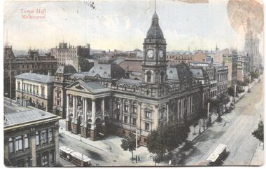
Postcard, "Town Hall Melbourne", mid 1900's?
Divided back postcard featuring a hand coloured image of Melbourne Town Hall, corner of Swanston St and Collins St. Has the title of "Town Hall Melbourne" and two cable cars in the corners. Rear has a message address to Miss V Hall of Greenhills via Blackwood, a Victorian 1d stamp dated stamped 29-6-1906 Melbourne, possibly from a Elsie. No printer detailstrams, tramways, town hall, cable trams, swanston st, collins st -
 Melbourne Tram Museum
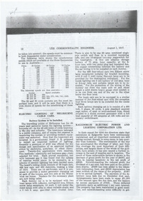
Document - Photocopy, The Commonwealth Engineer, "Electric Lighting of Melbourne Cable Cars", "Electric Lighting for Melbourne Trams", 1917
Photocopy of an article from The Commonwealth Engineer, dated 1/8/1917, titled "Electric Lighting of Melbourne Cable Cars". Describes the battery system, the number of cars, the use of a motor generator at each depot, the lamps and the system on each car. Also has a start of a short item on the Kalgoorlie Electric Tramways Annual report. Short report in the same journal, 1/11/1917 titled Electric Lighting for Melbourne Trams", about a contract issued by the Tramway Board to the General Electric company for approximately 40,000 pounds. Also has an item about King River hydro electric power and the standardisation of the electrical industry.trams, tramways, cable trams, tramcars, lights, depots, general electric -
 Port Melbourne Historical & Preservation Society
Document - Voter Rolls, City of Port Melbourne, Port Melbourne City Council, 1940s - 1970s
Seven Voter lists, City of Port Melbourne. Boundary Ward, 1951. Centre ward 1951. Centre ward 1975. Sandridge ward 1963. Boundary Ward 1963. Sandridge ward 1963. All wards late 1940s to early 1950slocal government - city of port melbourne -
Port Melbourne Historical & Preservation Society
Map - Settled districts around Melbourne, 1850s
Map of the settled districts around Melbourne in the Colony of Victoria, late 1850smelbourne -
Port Melbourne Historical & Preservation Society
Map - Melbourne and suburbs, Department of Lands and Survey, 1 May 1934
Large printed map of Melbourne and suburbs 1936 showing historic sightsmelbourne, south melbourne, transport - tramways, transport - railways -
Greensborough Historical Society
Book, Melbourne Water, Plenty River Waterway Management Activity Plan 2000, 2000_
This report covers the catchment of the Plenty River from its upper reaches in the Great Dividing Range to the confluence with the Yarra River at Viewbank. It discusses ecological diversity and methods of improving water quality and significant areas of the catchment. Includes a brief history of settlement along the Plenty River.This is a significant plan for the improvement of the Plenty River.207 p., maps, folding maps. Printed on white paper with black spiral binding and clear plastic front cover.plenty river, melbourne water -
 Ringwood and District Historical Society
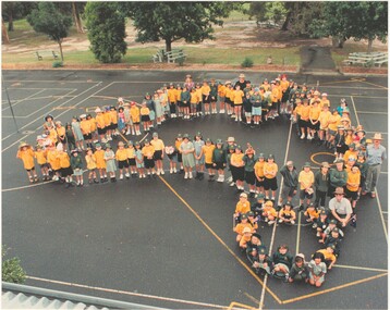
Photograph, Southwood Primary School staff and student photo forming map of Australia outline (undated) - circa 1997-8
colour photoSOUTHWOOD Primary School students and staff -
 Ringwood and District Historical Society
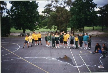
Photograph, Southwood Primary School - photograph of students on quadrangle with a large map of Australia drawn on the ground
photograph -
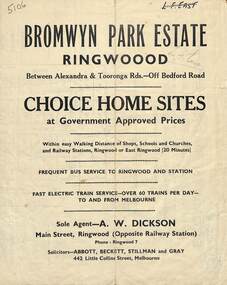 Ringwood and District Historical Society
Flyer, Bromwyn Park Estate, Ringwood - 1946 - Avertising Brochures and Map
Two pages of subdivision features, services and locationSubdivision plan includes Alexandra Road, Marwarra Street, Tooronga Road, Hilary Grove, Morcom Avenue. -
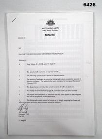 Bendigo Military Museum
Administrative record - Army Survey Regiment Map Production System Configuration GESS/RSSS, 11 May 1995
This minute encloses a copy of the Software Licence Agreement with Intergraph Corporation Pty Ltd that applies to the software packages within the Automap Raster Sub System (RSSS) and the Graphic Edit Sub System (GESS) at the Army Survey Regiment.A4 Army Survey Regiment Minute - Author AJ Spurling Manager Tech Spt Gp 11 May 95royal australian survey corps, rasvy, fortuna, army survey regiment, army svy regt, asr, intergraph corporation -
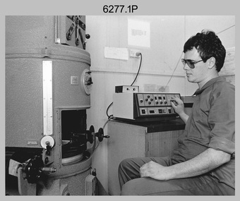 Bendigo Military Museum
Photograph - Map Production and Technical Services – Army Survey Regiment, Fortuna, Bendigo, July 1986
This is a collection of six photos of personnel and civilians undertaking technical tasks from Technical Services and the Air Survey, Cartographic and Lithographic Squadrons. The photos were taken at the Army Survey Regiment, Fortuna, Bendigo in July 1986. This is a set of six photographs of Army Survey Regiment personnel and civilians undertaking technical activities at Fortuna, Bendigo, in July 1986. The photographs were printed on photographic paper and are part of the Army Survey Regiment’s Collection. The photographs were scanned at 300 dpi. .1) - Photo, black & white, 1986, BARCRO work area WILD U4A Diapositive Camera, SPR Rob Jones. .2) - Photo, black & white, 1986, Aerotriangulation work area, SSGT Greg Buckingham. .3) - Photo, black & white, 1986, Technical Services in Building 16A. L to R: SSGT Andy Wilson, Tony Spurling, Pat Thwaites. .4) - Photo, black & white, 1986, RAAF Charting, L to R: SGT Paul Leskovec, SPR Toni Martin, FLT LT Don Stebbings .5) - Photo, black & white, 1986, Camera Section, CPL John Whaling. .6) - Photo, black & white, 1986, Print Troop, SPR Daryl South..1P – Annotated on back ‘JUL 86 SPR Rob Jones Barcro’ .2P – Annotated on back ‘JUL 86 SSGT Greg Buckingham Aerotrig’ .3P – Annotated on back ‘JUL 86 SSGT Andy Wilson, Mr Tony Spurling, Mr Pat Thwaites. Tech Services’ .4P – Annotated on back ‘JUL 86 SGT Paul Leskovec CSM, SPR Tony Martin, FLT LT Don Stebbings RAAF Charting’ .5P – Annotated on back ‘JUL 86 CPL John ‘Junior’ Whaling Camera Section LITHO’ .6P – Annotated on back ‘JUL 86 SPR Daryl South LITHO SQN’royal australian survey corps, rasvy, army survey regiment, army svy regt, fortuna, asr, air survey, litho, carto -
 Warrnambool and District Historical Society Inc.
Documents, Swintons Paper att 18/53 Merri St. Contract. Map. Notes, 1959
These documents relate to the sale of land in Merri Street Warrnambool in 1959 by Swintons Pty Ltd of Warrnambool. The buyer of the land was George O’Grady, a Warrnambool baker. The land sold for £4000 and there was a shed on the land (called the ‘Office’) which George O’Grady indicated he wished to be included in the sale. William and Ann Swinton migrated to Australia in 1854 and for a decade William Swinton worked as a builder and carpenter in the Warrnambool area, erecting many buildings, including the Wangoom Presbyterian Church. In 1865 he opened a store in Timor Street Warrnambool, selling groceries, hardware, china and glassware. By 1888 the business was known as William Swinton and Sons. Branch stores were opened in Wangoom, Cudgee, Nullawarre, South Warrnambool and West Warrnambool. After William Swinton died his son Robert became the first managing director of Swintons Pty Ltd. In 1934 the business split with George Swinton and Sons selling clothing, furnishings and glassware and Swintons Pty Ltd selling seeds, produce and hardware. Today the Swinton family still operates a furniture and bedding shop in Timor St Warrnambool.These items are of some interest as being connected to the Warrnambool business of Swintons Pty Ltd. They will be of interest to researchers. The current Swinton business in Timor Street is the oldest family business in Warrnambool and, with the name Swinton associated with businesses in Timor Street Warrnambool for 152 years it is amongst the oldest family businesses in Australia.The items here relate to the sale of land by Swintons Pty Ltd., Warrnambool. .1 These are three pages of white paper with typed material, a lawyer’s signature in blue ink, one green stamp and a sketch of the land location. .2 This is a sheet of thick paper containing a plan of the land sold. The paper has printed material and a sketch of the land with part of it coloured in pink. .3 This is a small piece of paper torn at the bottom right edge. It has handwritten material (a letter) in blue ink..2 ‘Plan of Survey of Part of Crown Allotment 18 Section 3 Township of .2 ‘Plan of Survey of Part of Crown Allotment 18 Section 3 Township of Warrnambool Parish of Wangoom County of Villiers’ .3 ‘Tuesday Dear Mr Swinton I am writing to say that I would like to have the ‘Office’ Thanking You George O’Grady’swinton family,, warrnambool -
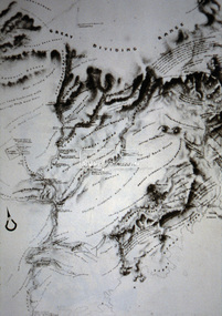 Eltham District Historical Society Inc
Slide - Photograph, Old map of Diamond Creek catchment, c.Sep. 1989
Part of a slide show presentation "Bridges & Waterways of the Shire" by Russell Yeoman to the 13 September 1989 Society meeting. The presentation included slides of historic photos from the Shire of Eltham Pioneers collections as well as several recent views.35mm colour positive transparency (1 of 33) Mount - Agfa CS System grey 8 dotsProcess Date Sep 1989diamond creek catchment, map -
 Eltham District Historical Society Inc
Slide - Photograph, Army Map, Yan Yean (Part, 1934), c.Aug. 1990
Part of a presentation, "Roads and Byways of the Shire of Eltham", by Russell Yeoman to the 12 September 1990 Society meeting. Slides shown included copies of old photos and recent images ranging from the suburban streets of Eltham and Montmorency to the mountain roads of Kinglake. In the byways category are views of some iof the Shire's bicycle paths including then recently completed sections of the Main Yarra Trail at Lower Plenty.35mm colour positive transparency (1 of 37) Mount - Agfachrome Agfa CS System black 8 dotsinfrastructure, roads, map, shire of eltham -
 Federation University Historical Collection
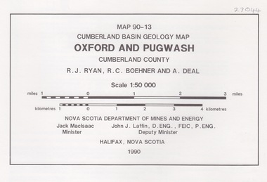
Map - Geological, Oxford and Pugwash: Cumberland Basin Geology Map, 90-13
-
 Federation University Historical Collection
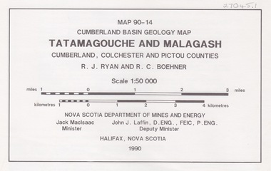
Map - Geological, Tatamagouche and Malagash: Cumberland Basin Geology Map, 90-14
-
 Federation University Historical Collection
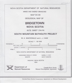
Map - Geological, Bridgetown, Nova Scotia Geology Map 94-08: South Mountain Batholith Project
-
 Federation University Historical Collection
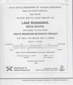
Map - Geological, Lake Rossignol, Nova Scotia: Glacial and Till Clast Map 94-09: Souh Mountain Batholith Project
-
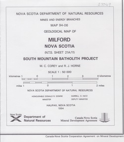 Federation University Historical Collection
Map - Geological, Milford, Nova Scotia, Geological Map 94-06: South Mountain Batholith Project
-
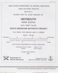 Federation University Historical Collection
Map - Geological, Weymouth, Nova Scoti, Glacial and Till Clast Map 94-11
-
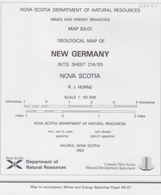 Federation University Historical Collection
Map - Geological, New Germany Nova Scotia, Geological Map 93-01
-
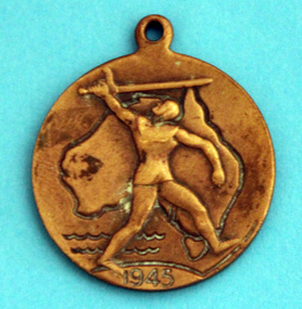 Koroit & District Historical Society
WWII school peace memorial 1945, Front with map of Australia, 1945
wwii, school, peace, medal, world war two -
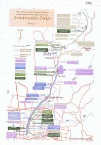 Greensborough Historical Society
Maps, Yan Yean Water Supply System Conservation Management Plan: Construction dates Map 1, 2007_
Plan of Yan Yean Water Supply System, showing natural and constructed features from 1850s to 1930s from Silver Creek Weirs to Eastern Freeway.Printed in colour one side. 3 copieswater supply, yan yean reservoir, plenty river -
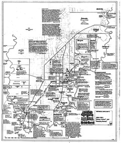 Greensborough Historical Society
Map, Heidelberg: Historic River Landscape Assessment. Historical maps. Map D 1864 -1901 "Sleepy Hollow" and "Sleeping beauty", 1985c
Geographical area of c. 35 sq. kilometres marked with physical features such as major roads, rivers, vegetation and properties, with locations and notes on the increasing number of farms, orchards and vineyards that had been developed in addition to pastoral runs. Bounded by Shire of Diamond Valley to the North, Darebin Creek to the West, and Plenty River to the East.Black and white sketch on white paper. Second copy 600 x 430 cm printed in black on semi-opaque paperheidelberg, heidelberg - maps -
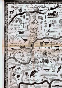 Greensborough Historical Society
Map, George W. Bell, Eltham Warrandyte and environs: a visitor's guide map: centenary souvenir. 2nd ed, 1994c
Tourist guide to historic and other features in the Eltham Warrandyte area and environs, A2, black & white, folded 3 times to A5, printed on one sidewarrandyte, eltham, st helena, montmorency -
![Planning Document, Plan of proposed subdivision of land in Greensborough [Map shows Scotland house], 01/04/1971](/media/collectors/4f729f5697f83e03086015b8/items/5982a68921ea6b1420e4e560/item-media/59916fb521ea681094908d7a/item-fit-380x285.jpg) Greensborough Historical Society
Greensborough Historical SocietyPlanning Document, Plan of proposed subdivision of land in Greensborough [Map shows Scotland house], 01/04/1971
This subdivision of Greensborough shows the home of John Scotland (died 1888) and surrounding area bounded by Hailes, William, Lorimer, and Jessop Streets.Photocopy of plan, 2 pages.Part of plan (68G) of proposed subdivision of Greensborough, part of Crown Portion 18, Parish pf Keelbundora. Scale: 132 ft. to an inchjohn scotland, hailes street greensborough, william street greensborough, lorimer street greensborough, jessop street greensborough -
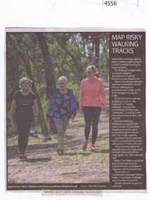 Greensborough Historical Society
Newspaper Clipping, Diamond Valley Leader, Map risky walking tracks, 29/03/2017
Walkers are being urged to dob in dubious walking tracks in a bid to attract funding for improvements.News article 1 page, black text, colour image.walking tracks, walkspot project, womens walking wanderers -
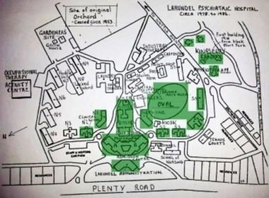 Greensborough Historical Society
Photograph - Digital Image, Marilyn Smith, Larundel map and sign, 05/09/2017
This photograph shows the signs at the old Larundel site. Some buildings on this site are heritage listed on the Victorian Heritage Database.Digital copy of colour photographlarundel hospital -
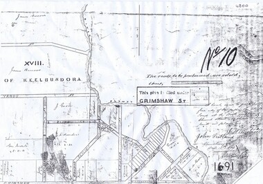 Greensborough Historical Society
Plan, Parish Plan Map of Land North of Grimshaw Street, 11/12/1879
Part of Parish plan of land north of Grimshaw Street bounded by the Plenty River. Includes annotation signed by John Scotland and J. W. Britnell, dated Dec. 11th 1879.Photocopy of part of Parish plan of land north of Grimshaw Street bounded by the Plenty River. Includes annotation signed by John Scotland and J. W. Britnell, dated Dec. 11th 1879greensborough, grimshaw street greensborough, jonah britnell, john scotland -
4th/19th Prince of Wales's Light Horse Regiment Unit History Room
Booklet, Radio Printing Press Pty Ltd, Map Reading and Field Sketching 1940, 1940
Soft covered booklet compiled and written by Capt A S Keighley MC showing the use of the protractor and field compass and reconnaissance for Battalion Intelligencemanual, map reading, field sketching