Showing 179143 items
matching streets
-
 Lakes Entrance Regional Historical Society (operating as Lakes Entrance History Centre & Museum)
Photograph, 2000 c
Avenue of Queensland brush box trees planted as memorial to John Carpenter pioneer builder of Lakes EntranceColour photograph of Roadknight Street looking east towards Whiter Street and crossroads Mourilyan Street and Stock Street before Norfolk Pine was removed early 2000s Lakes Entrance Victoriatopography -
 Kew Historical Society Inc
Photograph - Street Works, Studley Park Road, March 1934
Studley Park Road, like most streets in Kew, was originally a dirt road. Street works during the Great Depression included bituminising major roads in the district. This photograph of Council works originated in the City of Kew Engineers Department as a record of works undertaken. It was given to the collection by a Mrs Fisher in 1998.Well provenanced photograph of Council-funded public works in Kew during the Great Depression. Original sepia monochrome positive of Council workers standing on and beside a dray in Studley Park Road, Kew while resurfacing of the street was taking place. The Kew Junction is just visible behind the men.Typed reverse: "B4 / Kew C.C. / Spreading premixed material on Studley Park Road with drag spreader, view from rear of machine, March 1934"roadworks -- kew (vic.), street works -- kew (vic.), public works kew (vic.), studley park road -- kew (vic.), city of kew -- engineers department, city of kew -- public works -- great depression -- 1930s -
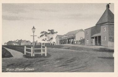 Phillip Island and District Historical Society Inc.
Photographs, Rose Stereograph Co. et al, Early Cowes, Phillip Island, 20th Centure
A collection of three photographs donated by Thelma Fithall.Three Black & White photograph/postcards of Cowes, Phillip Island. 282-01. The Main Street, Thompson Avenue, Cowes, Phillip Island. 282-02. Looking down to the Cowes Pier with a large crowd of people and several old vehicles. 282-03. The Esplanade, Cowes showing the Isle of Wight Hotel, several vehicles and people.282-01. Main Street, Cowes. 282-02. Valentine Series No. 2262. The Pier, Cowes. 282-03. Valentine Series No. 3396. The Esplanade, Cowes.cowes foreshore - cowes pier - phillip island, the esplanade cowes, isle of wight hotel - cowes phillip island, main street cowes, phillip island -
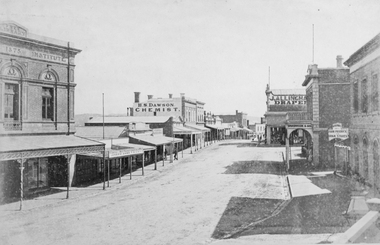 Stawell Historical Society Inc
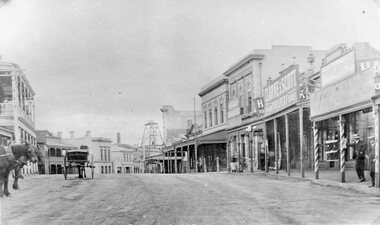
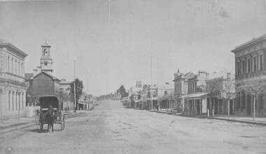
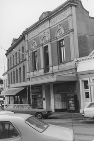
Photograph, Upper Main Street Stawell looking West with the Mechanics institute built in 1875 1878
Upper Main Street looking West from Mechanics Institute built in 1875. Mechanics Institute, Joseph Dawe Stawell Meat Market, D.B. O'Callaghan, Boot & Shoe Warehouse, Stawell Potato Depot, Ben S. Dawson Chemist, R.H. Wadsworth Jewler Watchmaker, English Scottish & Australian Bank, Bone Saddler, Hunter Bull & Mouth Hotel. On North side of street is J. Allingham Draper, Chadwick & Co Draper, D. Telford Farm Produce, Bank of Victoria. Photo taken 1878The "Top End" of Main Street. looking west. The Mechanics Insitute on the Left dates the photo about 1880. Some of the larger buildings have been restored.Victorian Views. C. Herbert, Photo. Stawell 1878stawell business streetscape -
 Yarra Glen & District Historical Society
Sepia postcards, State School Yarra Glen 19th century
Faded sepia photograph of the Yarra Glen State School taken from the School Lane (now called Yarraview Road). In the foreground are two schoolboys and three large trees. Post-and-rail fences are on either side of the road. In the distance is the school building on Symond Street.On the back at the top "POST CARD". Below that is "FOR CORRESPONDENCE" to the left and "FOR ADDRESS ONLY" to the right. Centre right is a stamp "YARRA GLEN/Mrs. E. Smith/SYMONDS STREET/YARRA GLEN 3775"yarra glen, post and rail fence, yarra flats, yarra glen state school, yarra glen primary school, symond street, school lane, yarraview road, schoolboys, school boys -
Port Melbourne Historical & Preservation Society
Photograph - Four men outside a house, Station Street, Port Melbourne, 1800s
Photographic copy of a photograph of a house in Station Street with four men in front. All wear shirts and hats, three wear jackets, two of these have ties, the other a scarf. The coatless man appears to have a corncob pipe in his mouth. These men are related to the Smith family, one of them being the house owner who is married to a Smith girl. Large tree visible on left, and a tree behind the distinctive picket fence. Date is unknown; probably 1800s.Photo has been mounted, velcoo's and marked in felt pen 'copy of photo belonging to Margaret Couch, Princes Street'.built environment - domestic, families, margaret smith couch -
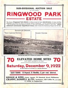 Ringwood and District Historical Society
Flyer, Sub-divisional auction sale advertisement - Ringwood Park Estate, Ringwood, Vic. - 1922
Folded double-sided page with black and white photographs of local views with black and red print advertising auction sale on Saturday 9th December, 1922, - 70 residential home sites, including terms of sale, locality map, and description of local facilities and services. Subdivision includes Wonga Road (later Loughnan Road), William Street, Andrew Street, and Harrison Street. Vendors Solicitors - Rigby & Fielding, 60 Market Street, Melbourne. Estate Agents - Keogh & King, 70 Elizabeth Street, Melbourne, Telephone 6938. Auctioneer - Cranny, Sambell & Co., 325 Collins Street, Melbourne, Telephone Central 5067 and 5077. -
 Warrnambool and District Historical Society Inc.
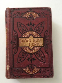
Book, Drawing of Genius, c.1870
‘Dawnings of Genius’ by the Rev. Theodore Alois Buckley contains chapters on the lives the many distinguished men in history. Our copy of this work was given to Jane McMeekin as a prize at the Koroit Street School some time in the 1870s. The Koroit Street School was a Denominational Board School opened by the Wesleyan Church in 1859 with William Nettleton as the Head Teacher. It was later known as Common School No. 673 and closed in 1876 when the Warrnambool State School in Jamieson Street was opened. There is no date to tell us when Jane McMeekin received this book but we know that Caleb Collyer, who married Ann Brown in 1869, was Head Teacher of Warrnambool Common School No. 673 in 1875. Jane Taggart McMeekin was born in Mepunga in 1864 to John and Isabella McMeekin. She may have been about ten or eleven when she received this prize. This book is of considerable interest as it was a school prize in the 1870s and concerns Jane McMeekin, Caleb Collyer and Common School No. 673 – all of relevance and importance in the history of education in Warrnambool.This is a hard cover book of 408 pages. It has a dark red leather cover with gold and black ornamentation and red lettering on a gold background. It has an introduction and thirty chapters on the lives of eminent men. It has many black and white illustrations. The cover is torn in places and somewhat stained and ragged around the edges. On the first page it has an inscription and a stamp of the Warrnambool & District Historical Society. ‘Second Prize, Fifth Class Girls, Awarded to Jane McMeekin, Koroit Street School, No. 673, Warrnambool, C. Collyer, H. Teacher.’ warrnambool common school 673, caleb collyer, jane mcmeekin, history of warrnambool, schools in warrnambool -
 Kew Historical Society Inc
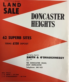
Plan - Subdivision Plan, Doncaster Heights
Real estate brochure produced for Smith & O'Shaughnessy of 900 Doncaster Road for the sale of the '65 superb sites' in the Doncaster Heights Estate. Streets with lots for sale include: Church Road, Norfolk Circuit, and Hampshire Road.Historic subdivision planFour-page colour real estate brochure issued for the sale of the Doncaster Heights Estate. The inside pages include a street plan with the numbered lots.subdivision plans - doncaster, doncaster heights estate -
 Kew Historical Society Inc
Plan, Melbourne & Metropolitan Board of Works : Borough of Kew : Detail Plan No.1564, 1905
The Melbourne and Metropolitan Board of Works (MMBW) plans were produced from the 1890s to the 1950s. They were crucial to the design and development of Melbourne's sewerage and drainage system. The plans, at a scale of 40 feet to 1 inch (1:480), provide a detailed historical record of Melbourne streetscapes and environmental features. Each plan covers one or two street blocks (roughly six streets), showing details of buildings, including garden layouts and ownership boundaries, and features such as laneways, drains, bridges, parks, municipal boundaries and other prominent landmarks as they existed at the time each plan was produced. (Source: State Library of Victoria)This plan forms part of a large group of MMBW plans and maps that was donated to the Society by the Mr Poulter, City Engineer of the City of Kew in 1989. Within this collection, thirty-five hand-coloured plans, backed with linen, are of statewide significance as they include annotations that provide details of construction materials used in buildings in the first decade of the 20th century as well as additional information about land ownership and usage. The copies in the Public Record Office Victoria and the State Library of Victoria are monochrome versions which do not denote building materials so that the maps in this collection are invaluable and unique tools for researchers and heritage consultants. A number of the plans are not held in the collection of the State Library of Victoria so they have the additional attribute of rarity.Original survey plan, issued by the MMBW to a contractor with responsibility for constructing sewers in the area identified on the plan within the Borough of Kew. The plan was at some stage hand-coloured, possibly by the contractor, but more likely by officers working in the Engineering Department of the Borough and later Town, then City of Kew. The hand-coloured sections of buildings on the plan were used to denote masonry or brick constructions (pink), weatherboard constructions (yellow), and public buildings (grey). In 1905, when Plan No.1564 was printed, that part of Kew bordered by Brougham Place (now Daniell Place), Mount Street, Sackville Street and Ross Street was already the location of a number of large mansions. Here, subdivisions, at least at this stage, produced larger blocks than in Central Kew. Many of the houses on this plan are named: ‘Faybrook’, ‘Northumbria’, ‘Parkholm[e]’, ‘Dunboe’, ‘Katoomba’ and ‘Eschol’ fronting Sackville Street. Eschol was once the home of the manufacturer Robert Harrison, whose cordial factory in Spring and Argyle Streets Fitzroy are noted on the Victorian Heritage Register. ‘The Hawthorns’ on the corner of Brougham Place and Mount Street was the home of the medical practitioner Frank William Fay, who won the military cross and other honours for conspicuous gallantry and devotion to duty in World War 1.melbourne and metropolitan board of works, detail plans, mmbw 1564, cartography -
 Kew Historical Society Inc
Plan, Melbourne & Metropolitan Board of Works : Borough of Kew : Detail Plan No.1572, 1905
The Melbourne and Metropolitan Board of Works (MMBW) plans were produced from the 1890s to the 1950s. They were crucial to the design and development of Melbourne's sewerage and drainage system. The plans, at a scale of 40 feet to 1 inch (1:480), provide a detailed historical record of Melbourne streetscapes and environmental features. Each plan covers one or two street blocks (roughly six streets), showing details of buildings, including garden layouts and ownership boundaries, and features such as laneways, drains, bridges, parks, municipal boundaries and other prominent landmarks as they existed at the time each plan was produced. (Source: State Library of Victoria)This plan forms part of a large group of MMBW plans and maps that was donated to the Society by the Mr Poulter, City Engineer of the City of Kew in 1989. Within this collection, thirty-five hand-coloured plans, backed with linen, are of statewide significance as they include annotations that provide details of construction materials used in buildings in the first decade of the 20th century as well as additional information about land ownership and usage. The copies in the Public Record Office Victoria and the State Library of Victoria are monochrome versions which do not denote building materials so that the maps in this collection are invaluable and unique tools for researchers and heritage consultants. A number of the plans are not held in the collection of the State Library of Victoria so they have the additional attribute of rarity.Original survey plan, issued by the MMBW to a contractor with responsibility for constructing sewers in the area identified on the plan within the Borough of Kew. The plan was at some stage hand-coloured, possibly by the contractor, but more likely by officers working in the Engineering Department of the Borough and later Town, then City of Kew. The hand-coloured sections of buildings on the plan were used to denote masonry or brick constructions (pink), weatherboard constructions (yellow), and public buildings (grey). Plan No. 1572 represents the built environment bordered by Barkers Road, Wrixon Street, Edgevale Road and Fitzwilliam Street. Other streets identified on the plan include Stansell Street. Plan 1572 shows that by 1903-05, there was only patchy development in this area of Kew, mainly on Edgevale Road and Fitzwilliam Street. Only two named houses are identified: the quaintly named ‘Tweed Cottage’, and ‘Mendip’. The earliest reference to Treed Cottage in Australian newspapers is to the death of Walter Thompson, aged 74 who was a resident there in 1885. His youngest daughter was to die there in 1908. Mendip to the north of Tweed Cottage was owned by Henry Thompson; he was to die in 1901; his wife in 1932. At this period of time, Malin Street and Clivedon Court did not extend to Barkers Road.melbourne and metropolitan board of works, detail plans, mmbw 1572, cartography -
 Marysville & District Historical Society
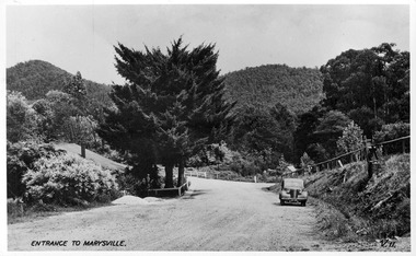
Postcard (item) - Black and white postcard, Valentine Publishing Co. Pty. Ltd, Entrance to Marysville V.11, 1923-1963
A digital copy of an early black and white photograph of the Marysville-Wood's Point Road at the corner with Murchison Street in Marysville in Victoria.A digital copy of an early black and white photograph of the Marysville-Wood's Point Road at the corner with Murchison Street in Marysville in Victoria. This postcard was published by the Valentine Publishing Co. Pty. Ltd. as a souvenir of Marysville.marysville, victoria, postcard, valentine publishing co, souvenir, murchison street, marysville-wood's point road -
 Stawell Historical Society Inc
Photograph, Upper Main Street Stawell looking East with on left the 2 story Allingham building & behind the cart is the Commercial Hotel c1910 -- 2 Photos -- 1 Colour
Upper Main Street Stawell. Looking East c1910. On left two story Allingham building behind cart is Commercial Hotel. Oriental Bank. Punchard Furniture. Crown Cross Poppet head visible on Big Hill. The side of the Mechanics Institute visible near centre. H S Dawson Chemist. Clarke & Scott Drapery on right. Same as 6730-1 & 2785View along upper Main Street looking East towards Big Hill. Poppet Head in distance at centre.stawell streetscape, mining -
 The Beechworth Burke Museum
Photograph, 1875
This photograph was taken in the winter of 1875 from the Telegraph Station looking up Ford Street towards the Church of England. Picture is a horse and wagon walking towards the camera. Black and white rectangular postcard. The image is printed on matt photographic paper and mounted on cardboard. This photograph depicts Ford Street looking south C 1875 in Beechworth.Obverse: NO INSCRIPTION Reverse: 5570 35 Beechworth about 1875 American & Australian Photographic Company. Victoria Branch. C. BAYLISS, Manager No. 61 Extra Copies may be had by sending Number to present Address. beechworth, ford street, 1875, horse, wagon, horse and wagon, church of england, burke museum, winter -
 Federation University Historical Collection
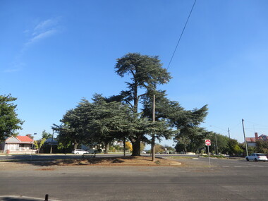
Photograph, Atlantic Cedar in South Street, Ballarat, 13/04/2020
Colour photograph of an Atlantic Cedar (Cedrus atlantica glauca) on the intersection of South Street, Skipton Street and Lyons Street South, Ballarat.ballarat, skipton street, lyons street north, tree, atlantic cedar, south street -
 Federation University Historical Collection
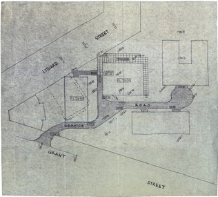
Plan, Plan for a Service Plan at the Ballarat School of Mines
This plan appears to show buildings that were not built. Plkan showing the section of the Federation University SMB Campus between Grant Street and Lydiard Street, near Armstrong Street South.smb campus, ballarat school of mines, grant street, lydiard street, former ballarat supreme court -
 Bendigo Historical Society Inc.
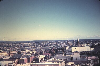
Slide - BENDIGO & EASTER FAIR, 1963
View from Rosalind Park tower looking south across View street and Forest Street, church in Forest Street in slide.slide, bendigo, city view -
Port Melbourne Historical & Preservation Society
Photograph - Outline of demolished house (139 Station Street), 137 Station Street, Port Melbourne, Peter Libbis, 6 May 1998
Taken by Peter Libbis between demolition and rebuilding of 139One of four photos of 137 Station Street, showing outline of wall of demolished 139 Station Street (corner of Spring Street)demolitions -
Port Melbourne Historical & Preservation Society
Document - Specification, Metalling and chanelling, Clark Street from Graham Street to Poolman Street, Engineering Department, Town of Port Melbourne, 14 Mar 1893
Specification for metalling channelling Clark Street from Graham Street to Poolman Street Loan Works 1893; relates to plan 96.2Signed by JJ Bartlett (Mayor)engineering - roads streets lanes and footpaths, arthur victor heath, town clerks, james john bartlett, mayors -
Port Melbourne Historical & Preservation Society
Plan - Metalling and channelling Clark Street from Graham Street to Poolman Street, Engineering Department, Town of Port Melbourne, 14 Mar 1893
Plan for metalling channelling Clark Street from Graham Street to Poolman Street Loan Works 1893; relates to specification 96.1Signed by JJ Bartlett (Mayor)engineering - roads streets lanes and footpaths, arthur victor heath, town clerks, james john bartlett, mayors -
Port Melbourne Historical & Preservation Society
Document - Specification, Pool Street from Nott Street to Princes Street, Engineering Department, Town of Port Melbourne, 14 Mar 1893
Plan for Pool Street from Nott Street to Princes Street Loan Works 1893 plan 18; relates to plan 97.2Signed by JJ Bartlett (Mayor) 14.3.1893engineering - roads streets lanes and footpaths, town planning, town clerks, mayors, arthur victor heath, james john bartlett -
Port Melbourne Historical & Preservation Society
Plan - Pool Street from Nott Street to Princes Street, Engineering Department, Town of Port Melbourne, 14 Mar 1893
Plan for Pool Street from Nott Street to Princes Street Loan Works 1893 plan 18; relates to specification 97.1Signed by JJ Bartlett (Mayor) 14.3.1893engineering - roads streets lanes and footpaths, town planning, town clerks, mayors, arthur victor heath, james john bartlett -
 Bacchus Marsh & District Historical Society
Photograph, Simpsons Butchery Main Street Bacchus Marsh 1883
John Simpson arrived in Bacchus Marsh around 1848. In 1850 he established a butchery business. He continued to operate this business in Main Street Bacchus Marsh until his death in 1890. His son John Simpson and one of his brothers, Edward took over the business and operated it until 1923. John Simpson the younger died in 1940 having lived all but a few months of his 92 years in Main Street Bacchus Marsh. Edward L. Simpson died in Corowa, NSW in 1937. The younger John Simpson's recollections of Bacchus Marsh in the 1850s to 1870s were published in the Bacchus Marsh Express on the 25 June 1932.Small sepia unframed photograph on card with gold border framing photograph. Housed in the album, 'Photographs of Bacchus Marsh and District in 1883 by Stevenson and McNicoll'. The image shows a butchery shop in Main Street Bacchus Marsh in 1883. The front of the building is shown. It is a solid brick or stone structure with a shingled roof and verandah. Hanging under the verandah are numerous carcasses and portions of meat. Two men are standing close together in front of the shop. One is wearing a butcher's apron. Another man to the left sits upon a horse. In the doorway behind the men stands a woman. On the front: Stevenson & McNicoll. Photo. 108 Elizabeth St. Melbourne. COPIES CAN BE OBTAINED AT ANY TIME. On the back: LIGHT & TRUTH inscribed on a banner surmounted by a representation of the rising sun. Copies of this Portrait can be had at any time by sending the Name and Post Office Money Order or Stamps for the amount of order to STEVENSON & McNICOLL LATE BENSON & STEVENSON, Photographers. 108 Elizabeth Street, MELBOURNE. stevenson and mcnicoll 1883 photographs of bacchus marsh and district, butcher shops, butchers, john simpson butcher 1848-1940, john simpson butcher died 1890 -
 Stawell Historical Society Inc
Photograph, Mechanics Institute in Upper Main Street Stawell 1970 -- Coloured and Black & white copies
Mechanics Institute Main Street Stawell. Used for many years as the library. Colour photo c1970s. Built in 1875 after the previous institute was damaged by fire in 1874. Architect Mr. George Inskip. Previous wooden institute destroyed by fire in 1866. McKellar Building in background. Hairdresser and Grampians real estate signs visible.Angle on photograph of Mechanics Institute Building. Cars parked in street in Foreground. Hairdresser and Grampians real estate signs visible.Mechanics Institute 1875stawell streetscape -
 Federation University Historical Collection
Article - Article - Metal plate, ZILLES COLLECTION: Metal Printers plate; T.W. Clark 205 Bourke Street Melbourne; Trade Mark
Zilles Printers was begun by Lewis Zilles in the early 1930s. It was in McKenzie Street Ballarat. His son Jeffrey also became a printer - letterpress, offset and screen printer. The business became Zilles Printers/Graphics and was in Armstrong Street and later Bell Street Ballarat. Metal plate made for T.W.Clark of 205 Bourke Street Melbourne. It is the Trade Mark stamp. Small brass coloured metal plate. Symbol and printing in reverse for stampingName of company - T.W. Clark 205 Bourke Street Melbourne written in circle with crown on top and kangaroo and emu in centre of circle. Scroll with Trade Mark at bottom of circle. Examples on various papers show stamp clearly.zilles, printers, ballarat, melbourne, t w clark, metal plate -
 Ballarat Tramway Museum
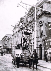
Photograph - Positioning street lights - Lydiard St North, Ballarat late 1890s, 2022 - Digital print
Photo of the installation of an electric arc type street lamp in Lydiard St North, near the Provincial Hotel Ballarat. The tower wagon is drawn by a single horse. Two boys standing alongside while two men are on the top of the wagon, a man on the top of the ladder is positioning a lifting beam while two men on the ground hold the rope for this beam. On the side of the wagon is possibly an extension that could be lifted onto the top of the tower itself to give a greater working height. The buildings between Mair St and the railway station on the west side of Lydiard St North remain in position. Yields information about the methodology of the late 1890's to install street lighting in BallaratDigital print of a Positioning street lights Lydiard St North Ballarat late 1890sarc lamps, ballarat, lydiard st north, electric lighting, tower wagons, horses, workmen, street lights -
 Ringwood and District Historical Society
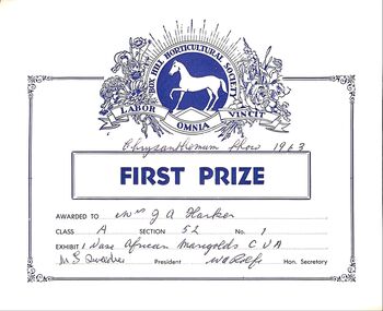
Certificate, Two First Prize Certificates awarded to Mrs. Ruby Harker at Box Hill Horticultural Society Chrysanthemum Show in 1963
Ruby Harker was Amy Thelma Wielands sister. The Certificates are in an envelope addressed to Mre. J.A. Harker 16, B, Churchill street , Mont Albert. Ruby's sister also lived in Churchill Street at one time after their house in Heathmont burnt down..2 buff coloured Cards with blue printing and the Box hill Horicultural Society crest at top. In a brown envelope with he address 16 B Churchill Street , Mont Albert. E 10. No post mark.