Showing 3760 items
matching surveyed
-
 Eltham District Historical Society Inc
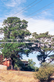
Photograph (Item) - Negative, Craig Price, Former Headmaster's Residence, Eltham Primary School, Dalton Street, Eltham, 1988
Craig Price 1988 Entrant No. 148 Ref: Series 34, Items 37, 38, 109, 110 The images in this record were not selected for inclusion. SHIRE OF ELTHAM COMMUNITY PHOTOGRAPHIC SURVEY Photography is an artform which many of us practice, sometimes purely for artistic pursuit, sometimes to record the people and events in our lives. In 1988, as part of a local Bicentennial project, the Shire of Eltham conducted the Eltham Community Photographic Survey. Up to 100 entries were to be selected by a panel of photographers for entry into the Eltham Photographic Survey Exhibition. Entries had to be submitted by May 13, 1988. Entrants whose images were selected for the exhibition were contacted and requested to further submit an entry form providing entrant’s name, area of residence, age, and proposed captions. These details were then used to produce labels for the exhibition mounts. Where negatives had not been supplied, these were requested to support the display of printed enlargements mounted on 10” x 8” cardboard. The mounted prints were made available post exhibition for sale at $8.50 each for colour prints and $7.00 for B&W prints. Residents in the Shire were invited to collect a free roll of film and take a photograph of what they either liked or did not like about the area. A total of 160 entrants submitted multiple entries for the exhibition. Of those selected for exhibition, entrants ranged in age from 9 to 70 years. All custom colour and black and white printing for the exhibition was completed by Wattle Studios of Eltham. The Eltham Photographic Survey was jointly auspiced by the Shire of Eltham and Wattle Studios, of 953 Main Road, Eltham. The project was greatly assisted by: • David McRitchie, Media Studies Lecturer Victoria College, Rusden Campus. • Ian and Annette Toohill of Wattle Studios • Tracy Naughton, Eltham Community Arts Officer • Neville Emerson Pty. Ltd. • Superior Press, Eltham • Kodak Australasia Pty. Ltd. • Agfa Gevaert Ltd. • Townsend Colourtech Pty. Ltd. • The Australian Bicentennial Authority • Eleanor Bowers, Secretary, Eltham Arts Council The exhibition was placed on display in the Woolworths Arcade, Eltham between Monday June 6th and Saturday June 11, 1988. It was also intended to hold the exhibition at a venue in the Shire’s North Riding from Monday, June 20 to Friday June 24. It was then displayed at the Were Street Theatre, Montmorency from Friday, June 24 to Thursday, July 7. Series 34: Eltham Community Photographic Survey 1988 - Prints & Documentation Series consists of 117 photographs of Shire scenes taken by members of the community. Items I - 41 are larger photographs mounted on card, which were exhibited. Items 42 - 117 are unmounted copies, alternative takes and other entries. Corresponding negatives contained in Series 35: Eltham Community Photographic Survey 1988 – Negatives which consists of 267 colour and B&W negatives and one colour slide of Shire scenes taken by members of the community. The negatives are arranged by the entrant number of the photographer. The Eltham Community Photographic Survey collection is significant to the local community as it was curated by the local community - ordinary people of all ages - representing what they liked and did not like in the area where they lived. It represents an unfiltered representation of the Shire of Eltham as it was in 1988. It also represents one of many projects as part of the national programme of events and celebrations to commemorate the bicentenary. It is a time capsule of life in the 1980s of this urban and rural municipality in Melbourne's north. shire of eltham archives, bicentennial project, eltham community photographic survey, craig price, film - kodak ga 100 5095, scan - 35mm negative, series 35, dalton street, eltham primary school, headmaster's residence, state school no. 209 -
 Eltham District Historical Society Inc
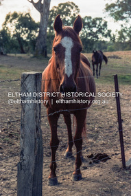
Photograph (Item) - Negative, Craig Price, Eltham Community Photographic Survey Entry, 1988
Craig Price 1988 Entrant No. 148 Ref: Series 34, Items 37, 38, 109, 110 The images in this record were not selected for inclusion. SHIRE OF ELTHAM COMMUNITY PHOTOGRAPHIC SURVEY Photography is an artform which many of us practice, sometimes purely for artistic pursuit, sometimes to record the people and events in our lives. In 1988, as part of a local Bicentennial project, the Shire of Eltham conducted the Eltham Community Photographic Survey. Up to 100 entries were to be selected by a panel of photographers for entry into the Eltham Photographic Survey Exhibition. Entries had to be submitted by May 13, 1988. Entrants whose images were selected for the exhibition were contacted and requested to further submit an entry form providing entrant’s name, area of residence, age, and proposed captions. These details were then used to produce labels for the exhibition mounts. Where negatives had not been supplied, these were requested to support the display of printed enlargements mounted on 10” x 8” cardboard. The mounted prints were made available post exhibition for sale at $8.50 each for colour prints and $7.00 for B&W prints. Residents in the Shire were invited to collect a free roll of film and take a photograph of what they either liked or did not like about the area. A total of 160 entrants submitted multiple entries for the exhibition. Of those selected for exhibition, entrants ranged in age from 9 to 70 years. All custom colour and black and white printing for the exhibition was completed by Wattle Studios of Eltham. The Eltham Photographic Survey was jointly auspiced by the Shire of Eltham and Wattle Studios, of 953 Main Road, Eltham. The project was greatly assisted by: • David McRitchie, Media Studies Lecturer Victoria College, Rusden Campus. • Ian and Annette Toohill of Wattle Studios • Tracy Naughton, Eltham Community Arts Officer • Neville Emerson Pty. Ltd. • Superior Press, Eltham • Kodak Australasia Pty. Ltd. • Agfa Gevaert Ltd. • Townsend Colourtech Pty. Ltd. • The Australian Bicentennial Authority • Eleanor Bowers, Secretary, Eltham Arts Council The exhibition was placed on display in the Woolworths Arcade, Eltham between Monday June 6th and Saturday June 11, 1988. It was also intended to hold the exhibition at a venue in the Shire’s North Riding from Monday, June 20 to Friday June 24. It was then displayed at the Were Street Theatre, Montmorency from Friday, June 24 to Thursday, July 7. Series 34: Eltham Community Photographic Survey 1988 - Prints & Documentation Series consists of 117 photographs of Shire scenes taken by members of the community. Items I - 41 are larger photographs mounted on card, which were exhibited. Items 42 - 117 are unmounted copies, alternative takes and other entries. Corresponding negatives contained in Series 35: Eltham Community Photographic Survey 1988 – Negatives which consists of 267 colour and B&W negatives and one colour slide of Shire scenes taken by members of the community. The negatives are arranged by the entrant number of the photographer. The Eltham Community Photographic Survey collection is significant to the local community as it was curated by the local community - ordinary people of all ages - representing what they liked and did not like in the area where they lived. It represents an unfiltered representation of the Shire of Eltham as it was in 1988. It also represents one of many projects as part of the national programme of events and celebrations to commemorate the bicentenary. It is a time capsule of life in the 1980s of this urban and rural municipality in Melbourne's north. shire of eltham archives, bicentennial project, eltham community photographic survey, craig price, film - kodak ga 100 5095, horse, scan - 35mm negative, series 35, brougham steet bridge, trees -
 Eltham District Historical Society Inc
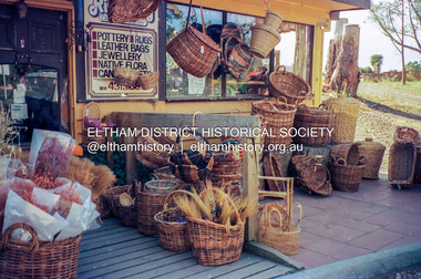
Photograph (Item) - Negative, Elizabeth Simkin, Riverclay Craft Gallery, 573 Main Road, Eltham, 1988
Riverclay was located along with Ansell and Muirs Chicken shop opposite El;tham Lower Park. The building has since been demolished as it lay within the 1934 flood plain limits. Elizabeth Simkin 1988 Entrant No. 149 Ref: Series 34, Items 39, 111-113 The images in this record were not selected for inclusion. SHIRE OF ELTHAM COMMUNITY PHOTOGRAPHIC SURVEY Photography is an artform which many of us practice, sometimes purely for artistic pursuit, sometimes to record the people and events in our lives. In 1988, as part of a local Bicentennial project, the Shire of Eltham conducted the Eltham Community Photographic Survey. Up to 100 entries were to be selected by a panel of photographers for entry into the Eltham Photographic Survey Exhibition. Entries had to be submitted by May 13, 1988. Entrants whose images were selected for the exhibition were contacted and requested to further submit an entry form providing entrant’s name, area of residence, age, and proposed captions. These details were then used to produce labels for the exhibition mounts. Where negatives had not been supplied, these were requested to support the display of printed enlargements mounted on 10” x 8” cardboard. The mounted prints were made available post exhibition for sale at $8.50 each for colour prints and $7.00 for B&W prints. Residents in the Shire were invited to collect a free roll of film and take a photograph of what they either liked or did not like about the area. A total of 160 entrants submitted multiple entries for the exhibition. Of those selected for exhibition, entrants ranged in age from 9 to 70 years. All custom colour and black and white printing for the exhibition was completed by Wattle Studios of Eltham. The Eltham Photographic Survey was jointly auspiced by the Shire of Eltham and Wattle Studios, of 953 Main Road, Eltham. The project was greatly assisted by: • David McRitchie, Media Studies Lecturer Victoria College, Rusden Campus. • Ian and Annette Toohill of Wattle Studios • Tracy Naughton, Eltham Community Arts Officer • Neville Emerson Pty. Ltd. • Superior Press, Eltham • Kodak Australasia Pty. Ltd. • Agfa Gevaert Ltd. • Townsend Colourtech Pty. Ltd. • The Australian Bicentennial Authority • Eleanor Bowers, Secretary, Eltham Arts Council The exhibition was placed on display in the Woolworths Arcade, Eltham between Monday June 6th and Saturday June 11, 1988. It was also intended to hold the exhibition at a venue in the Shire’s North Riding from Monday, June 20 to Friday June 24. It was then displayed at the Were Street Theatre, Montmorency from Friday, June 24 to Thursday, July 7. Series 34: Eltham Community Photographic Survey 1988 - Prints & Documentation Series consists of 117 photographs of Shire scenes taken by members of the community. Items I - 41 are larger photographs mounted on card, which were exhibited. Items 42 - 117 are unmounted copies, alternative takes and other entries. Corresponding negatives contained in Series 35: Eltham Community Photographic Survey 1988 – Negatives which coThe Eltham Community Photographic Survey collection is significant to the local community as it was curated by the local community - ordinary people of all ages - representing what they liked and did not like in the area where they lived. It represents an unfiltered representation of the Shire of Eltham as it was in 1988. It also represents one of many projects as part of the national programme of events and celebrations to commemorate the bicentenary. It is a time capsule of life in the 1980s of this urban and rural municipality in Melbourne's north. shire of eltham archives, bicentennial project, eltham community photographic survey, film - kodak ga 100 5095, elizabeth simkin, eltham, scan - 35mm negative, series 35, cane baskets, riverclay craft gallery -
 Eltham District Historical Society Inc
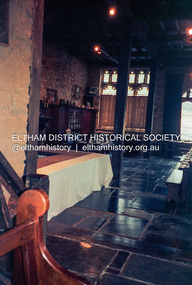
Photograph (Item) - Negative, Elizabeth Simkin, Interior, Great Hall, Montsalvat, 1988
Elizabeth Simkin 1988 Entrant No. 149 Ref: Series 34, Items 39, 111-113 The images in this record were not selected for inclusion. SHIRE OF ELTHAM COMMUNITY PHOTOGRAPHIC SURVEY Photography is an artform which many of us practice, sometimes purely for artistic pursuit, sometimes to record the people and events in our lives. In 1988, as part of a local Bicentennial project, the Shire of Eltham conducted the Eltham Community Photographic Survey. Up to 100 entries were to be selected by a panel of photographers for entry into the Eltham Photographic Survey Exhibition. Entries had to be submitted by May 13, 1988. Entrants whose images were selected for the exhibition were contacted and requested to further submit an entry form providing entrant’s name, area of residence, age, and proposed captions. These details were then used to produce labels for the exhibition mounts. Where negatives had not been supplied, these were requested to support the display of printed enlargements mounted on 10” x 8” cardboard. The mounted prints were made available post exhibition for sale at $8.50 each for colour prints and $7.00 for B&W prints. Residents in the Shire were invited to collect a free roll of film and take a photograph of what they either liked or did not like about the area. A total of 160 entrants submitted multiple entries for the exhibition. Of those selected for exhibition, entrants ranged in age from 9 to 70 years. All custom colour and black and white printing for the exhibition was completed by Wattle Studios of Eltham. The Eltham Photographic Survey was jointly auspiced by the Shire of Eltham and Wattle Studios, of 953 Main Road, Eltham. The project was greatly assisted by: • David McRitchie, Media Studies Lecturer Victoria College, Rusden Campus. • Ian and Annette Toohill of Wattle Studios • Tracy Naughton, Eltham Community Arts Officer • Neville Emerson Pty. Ltd. • Superior Press, Eltham • Kodak Australasia Pty. Ltd. • Agfa Gevaert Ltd. • Townsend Colourtech Pty. Ltd. • The Australian Bicentennial Authority • Eleanor Bowers, Secretary, Eltham Arts Council The exhibition was placed on display in the Woolworths Arcade, Eltham between Monday June 6th and Saturday June 11, 1988. It was also intended to hold the exhibition at a venue in the Shire’s North Riding from Monday, June 20 to Friday June 24. It was then displayed at the Were Street Theatre, Montmorency from Friday, June 24 to Thursday, July 7. Series 34: Eltham Community Photographic Survey 1988 - Prints & Documentation Series consists of 117 photographs of Shire scenes taken by members of the community. Items I - 41 are larger photographs mounted on card, which were exhibited. Items 42 - 117 are unmounted copies, alternative takes and other entries. Corresponding negatives contained in Series 35: Eltham Community Photographic Survey 1988 – Negatives which consists of 267 colour and B&W negatives and one colour slide of Shire scenes taken by members of the community. The negatives are arranged by the entrant number of the photographer. The Eltham Community Photographic Survey collection is significant to the local community as it was curated by the local community - ordinary people of all ages - representing what they liked and did not like in the area where they lived. It represents an unfiltered representation of the Shire of Eltham as it was in 1988. It also represents one of many projects as part of the national programme of events and celebrations to commemorate the bicentenary. It is a time capsule of life in the 1980s of this urban and rural municipality in Melbourne's north. shire of eltham archives, bicentennial project, eltham community photographic survey, film - kodak ga 100 5095, elizabeth simkin, eltham, scan - 35mm negative, series 35, great hall, montsalvat -
 Eltham District Historical Society Inc
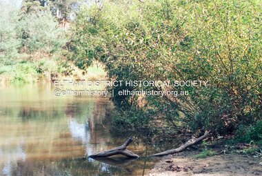
Photograph (Item) - Negative, Elizabeth Simkin, Yarra River, Eltham, 1988
Elizabeth Simkin 1988 Entrant No. 149 Ref: Series 34, Items 39, 111-113 The images in this record were not selected for inclusion. SHIRE OF ELTHAM COMMUNITY PHOTOGRAPHIC SURVEY Photography is an artform which many of us practice, sometimes purely for artistic pursuit, sometimes to record the people and events in our lives. In 1988, as part of a local Bicentennial project, the Shire of Eltham conducted the Eltham Community Photographic Survey. Up to 100 entries were to be selected by a panel of photographers for entry into the Eltham Photographic Survey Exhibition. Entries had to be submitted by May 13, 1988. Entrants whose images were selected for the exhibition were contacted and requested to further submit an entry form providing entrant’s name, area of residence, age, and proposed captions. These details were then used to produce labels for the exhibition mounts. Where negatives had not been supplied, these were requested to support the display of printed enlargements mounted on 10” x 8” cardboard. The mounted prints were made available post exhibition for sale at $8.50 each for colour prints and $7.00 for B&W prints. Residents in the Shire were invited to collect a free roll of film and take a photograph of what they either liked or did not like about the area. A total of 160 entrants submitted multiple entries for the exhibition. Of those selected for exhibition, entrants ranged in age from 9 to 70 years. All custom colour and black and white printing for the exhibition was completed by Wattle Studios of Eltham. The Eltham Photographic Survey was jointly auspiced by the Shire of Eltham and Wattle Studios, of 953 Main Road, Eltham. The project was greatly assisted by: • David McRitchie, Media Studies Lecturer Victoria College, Rusden Campus. • Ian and Annette Toohill of Wattle Studios • Tracy Naughton, Eltham Community Arts Officer • Neville Emerson Pty. Ltd. • Superior Press, Eltham • Kodak Australasia Pty. Ltd. • Agfa Gevaert Ltd. • Townsend Colourtech Pty. Ltd. • The Australian Bicentennial Authority • Eleanor Bowers, Secretary, Eltham Arts Council The exhibition was placed on display in the Woolworths Arcade, Eltham between Monday June 6th and Saturday June 11, 1988. It was also intended to hold the exhibition at a venue in the Shire’s North Riding from Monday, June 20 to Friday June 24. It was then displayed at the Were Street Theatre, Montmorency from Friday, June 24 to Thursday, July 7. Series 34: Eltham Community Photographic Survey 1988 - Prints & Documentation Series consists of 117 photographs of Shire scenes taken by members of the community. Items I - 41 are larger photographs mounted on card, which were exhibited. Items 42 - 117 are unmounted copies, alternative takes and other entries. Corresponding negatives contained in Series 35: Eltham Community Photographic Survey 1988 – Negatives which consists of 267 colour and B&W negatives and one colour slide of Shire scenes taken by members of the community. The negatives are arranged by the entrant number of the photographer. The Eltham Community Photographic Survey collection is significant to the local community as it was curated by the local community - ordinary people of all ages - representing what they liked and did not like in the area where they lived. It represents an unfiltered representation of the Shire of Eltham as it was in 1988. It also represents one of many projects as part of the national programme of events and celebrations to commemorate the bicentenary. It is a time capsule of life in the 1980s of this urban and rural municipality in Melbourne's north. shire of eltham archives, bicentennial project, eltham community photographic survey, film - kodak ga 100 5095, elizabeth simkin, eltham, scan - 35mm negative, series 35, yarra river -
 City of Moorabbin Historical Society (Operating the Box Cottage Museum)
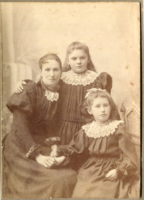
Photograph - Photograph, Mrs Carroll c1910, possibly c1910
Date unknown: Mrs Caroll and children. In 'Moorabbin A Pictorial History 1862 - 1994 ' by John Cribbin, The Carroll family migrated from Ireland and purchased land in the East Brighton ( now Bentleigh ) area of Henry Dendy's Special Survey 1841. Edward, J.W. & Daniel are shown in the Rate Book 1862 as owner occupiers and owner of property in Tuckers Road, Bryants Road and Centre Road.Photograph is black and white. There are three women in this photograph, a mother and her two children. The mother is sitting down on a chair to the left and her daughter sitting next to her, on the right (they are both holding hands), and her other daughter (child) right in between her mother and sister, with he arm around the mother's shoulder. All three of them are wearing their best dresses that have lace collars. As the clothes are similar to MAV Cat No. 00519 the photo may have been taken c 1910Front of Mount : Yeoman Co 287 Chapel St. Prahran, Victoria.children, chapel st, 287, prahran, carroll edward, carroll, j.w., carroll daniel, ireland, brighton, henry dendy's special survey 1841, market gardeners, pioneers, early settlers, dairy farmers, poultry farmers, bentleigh, mckinnon, ormond, prahran, yeoman photographers co. -
 Federation University Historical Collection
Map - Geological, Tallangatta, New South Wales: 1:250,000 Geological Series, SJ 55-3, 1966
Compiled by the Geological Survey of N.S.W., Division of Regional Geology. Topographical base compiled from Snowy Mountains Hydro Electrical Authority, Department of Lands, County maps and Snowy Lease Map. Other sheet adjoin this map. There are 13 formation sections grouped into 9 - Quaternary, Tertiary, Middle Devonian, Lower to Middle Devonian, Lower Devonian, Upper Silurian, Silurian, Upper Ordovician and Ordovician.Large coloured map showing geological features, faults, bores, rivers and mineral deposits.Scale of map, longitude and latitude, river names. "Tallangatta 1:250,00" written in black pen.tallangatta, new south wales, geological survey, topographical base, snowy mountains hydro electrical authority, department of lands, snowy lease map, department of mines, quaternary, tertiary, middle devonian, lower to middle devonian, lower devonian, uper siluran, silurian, upper ordovician, ordovician -
 Bendigo Military Museum
Administrative record - Joint Committee for the exchange of Information on ADP within the RASvy Corps, Activities Jun- Dec 1985, Army Survey Regiment, December 1985
Automated Computer Processing (ADP) was instrumental to the successful operation of the Royal Australian Survey Corps Mapping capability and production. This paper describes elements of the ADP with a comprehensive description of each. They Include, PDP 11/70 Memory, Map Stock Control System, Digital Terrain Elevation Data, Digital Terrain Model Package, ASMAPS, ASTIS, Reflectance Hill Shading, Aerial Triangulation and Terrain Analysis.Two page paper report about Automated Data Processing, unstapledHand annotated "Folio 74" in top right hand cornerroyal australian survey corps, rasvy, fortuna, army survey regiment, army svy regt, asr -
 Bendigo Military Museum
Administrative record - Army Survey Regiment - Report on Automated Data Processing since 1984
A comprehensive summary of Automated Data Processing at the Army Survey Regiment with a description of each. Textronix 4052, PDP 11/70, Quantex Replay Unit, Automap 1, Automap 2, Konsberg GT5000, RTE 6, Autochart, Plot 79, IGDS, Schut Bundle, DTM - Nucleus, DTM - Graphics, ASMAPS, ASTIS, PAT-B, PRE-B5, PAT-M, PRO-MS.Typed Report, 3 x foolscap photocopy pagesroyal australian survey corps, rasvy, fortuna, army survey regiment, army svy regt, asr -
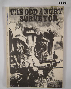 Bendigo Military Museum
Administrative record - Army Survey Regiment Regimental Training 1984 - The Odd Angry Surveyor, Army Survey Regiment, Bendigo, 21 Feb 1984
This is an Administrative Instruction setting out all aspects of the Army Survey Regiment Regimental Training Exercise "Odd Angry Surveyor" during the period 30 Apr - 12 May 1984. The Exercise conducted in two phases, Phase One- being theory lessons in a number of aspects of Infantry Minor Tactics at Section Level, whilst Phase Two- was putting into practice the lessons from Phase One.Light carboard covered A4 paper report stapled on left hand sideroyal australian survey corps, rasvy, fortuna, army survey regiment, army svy regt, asr -
 Lakes Entrance Regional Historical Society (operating as Lakes Entrance History Centre & Museum)
Photograph, P Hancock, 1900 c
Henry Froud's Blacksmith Coach Building and Wheelwright's business set up at original surveyed site west of present township, nearer to cemetery turnoff,. Business first moved to corner of Princes Highway and Bruthen Road, (now site of Black Stump Store), then moved to premises built by Harry Froud on south side of highway, corner of Punt Road, (present site of BP Garage).Black and white photograph of Harry Frouds first coach factory west of present township, showing three men in front of four wheeled vehicles including a steam engine. Three workshops in background, two having bark roofs, man in centre identified as Harry Froud, William Henry. Johnsonville Victoria.retail trade, transport -
 Bendigo Historical Society Inc.
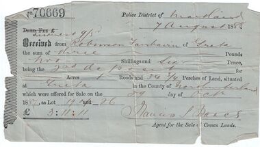
Document - Land purchase receipt, Maitland NSW, 1888-1889
Northumberland County was one of the original Nineteen Counties in New South Wales and is now one of the 141 Cadastral divisions of New South Wales. The Greta area was first colonized by Europeans around Anvil Creek in the 1830s. When the town was surveyed in 1842 it was given the name Greta, possibly after a small river in Cumberland, England. Coal mining was established in the area in 1862 with the development of a railway station. Robinson Fairbairn Collection: Land purchase receipt, Greta, Maitland NSW - 7th August 1888, Received from Robinson Fairbairn of Greta, 3 pounds and 11 shillings and 11 pence for land Lot 19 of 26, by agent for the Sale of Crown lands. 25% deposit receipt from Sparke and Glift auctioneers West Maitlandhistory, mining, robinson fairbairn collection, maitland, northumberland, greta nsw -
 Flagstaff Hill Maritime Museum and Village
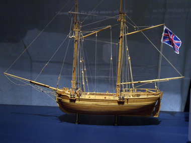
Craft - Ship Model, H.M.S. Lady Nelson, 1988
This model of the ship H.M.S. Lady Nelson was researched and built as the vessel Lady Nelson by David Lumsden, a professional ship model builder. His Majesty's Armed Survey Vessel Lady Nelson was commissioned in 1799 to survey the coast of Australia. This vessel was purpose-built before the British Admiralty requested plans for a Schooner for Port Jackson. At the time large parts of the Australian coast were unmapped and Britain had claimed only part of the continent. The British Government were concerned that, in the event of settlers of another European power becoming established in Australia, any future conflict in Europe would lead to a widening of the conflict into the southern hemisphere to the detriment of the trade that Britain sought to develop. Against this background, Lady Nelson was chosen to survey and establish sovereignty over strategic parts of the continent. Lady Nelson left Portsmouth on 18 March 1800 and arrived at Sydney on 16th December 1800 after having been the first vessel to reach the east coast of Australia via the Bass Strait. Before that date, all vessels had sailed around the southern tip of Tasmania to reach their destination. Lady Nelson's survey work commenced shortly after she arrived in Sydney, initially in the Bass Strait area. She was involved in the discovery of Port Phillip, on the coast of Victoria, in establishing settlements on the River Derwent and at Port Dalrymple in Tasmania. She also successfully chartered much of the Victorian coastline and was heavily involved with the exploration of the Queensland coast with Matthew Flinders; investigated the Hunter River; made numerous visits to New Zealand and Norfolk Island and was involved in the founding of numerous settlements. In comparison to most colonial vessels, the Lady Nelson was technically unique she was fitted with sliding keels, or centreboards, and water-tight trunks reaching to the deck. Captain Schank invented these sliding keels that, when raised, reduced her draught to less than six feet. Her life as an exploration vessel ended while accompanying HMS 'Tamar' to Melville Island in 1825, the 'Lady Nelson' was captured and later abandoned by pirates off the island of Babar (Indonesia). This brought the vessel's 25 years of coastal exploration and navigation to a close.The Lady Nelson made was the first British ship to survey of the southern or south-western coast of Australia and traverse the Bass Strait. The vessel holds a special place in Australia's history of exploration as the first to explore and establish settlements in the then-new British colony of Van Diemans Land. The model gives an insight into what life must have been like onboard sailing vessels of the time and Australia's early history of establishment and exploration. This model acts as an important legacy of the full-scale ship which no longer survives. Ship model of the 60 ton British brig HMS Lady Nelson. Timber model of a two-masted brig with rigging but no sails, displaying the British Union Jack flag. The ship is in a glass exhibition display case on metal stand. HMS Lady Nelsonflagstaff hill, warrnambool, shipwrecked coast, flagstaff hill maritime museum, maritime museum, shipwreck coast, flagstaff hill maritime village, great ocean road, by captain john schanck, sliding keels or centreboards, lady nelson, british brig hms lady nelson, david lumsden ship model builder, lieutennant james grant, bass strait discovery, surveying king island and port phillip bay, philip gidley king -
 4th/19th Prince of Wales's Light Horse Regiment Unit History Room
Badge Display
Display of metal unit badges in small wooden glass fronted case. Case has two folding supports on back. Badges are mounted on felt backing. Includes hat badges of RAAC, 1AR, HRL, PWLH, 2 CAV, 3 Cav, 4 Cav. Chaplains, Dental, Service Corps, Education, Sigs, Catering, Medical, Nursing, RAR, INt, Ord, MP, Psych, Pay, Band, Survey and shoulder titles of RAAC, 1AR, PWLH, PSYCH, AABC, RASVY and RAAPC. On case: ACME SHOWCARD CO LTD Makers Glebe Road London E8 -
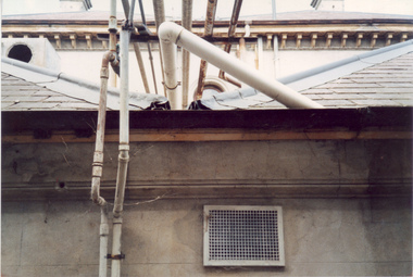 Villa Alba Museum
Photograph - Waste water pipes, c.1987
Built for William and Anna-Maria Greenlaw in the early 1880s, and with interiors decorated by the Paterson Bros, Villa Alba remained in private ownership until 1949. From 1950, the house was owned by a number of institutions. By 1984, the Villa Alba Preservation Society had been formed, and three years later, the Mount Royal Hospital granted a 25-year lease to Kew Council. In 2004, the title to Villa Alba was passed by the Victorian Government to The Villa Alba Museum Incorporated. The Museum, at 44 Walmer Street, Kew, is now a cultural institution committed to the collection, study and display of 19th century interior decorative finishes, and the components of 19th and 20th century interior decoration.This is one of a number of historically and aesthetically significant photos of the interiors and exterior of Villa Alba when it was still owned by the Mount Royal Hospital, showing twentieth century accretions and deterioration of the historic fabric of the building. This was a benchmark survey against which future conservation and restoration activities can be measured.In December 1987, Mockridge Stahle & Mitchell Pty Ltd Architects prepared ‘Villa Alba Survey: A Report on the fabric for Mount Royal Hospital’ of which this photograph is a part. Photo of numerous pipes, all installed during the period when the house was owned by the Royal Women's Hospital as a home for nurses (1950-1974). The pipes extended from a bathroom installed at the end of the first floor hall, running along the box gutter to the rear of the building. [The pipes were removed in subsequent restorations].villa alba museum, conservation photographs, victorian architecture, drain pipes, waste water -
 Mt Dandenong & District Historical Society Inc.
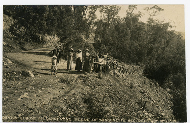
Photograph, Devils Elbow Mt. Dandenong Scene of Waggonette Disaster 27.12.1911, 1911
Original postcard showing a group of about 20 people surveying the scene of the Waggonette Disaster that occurred on the Coach Road at Devils Elbow on 27/12/1911. The accident occurred at Devil's Elbow where now the Old Coach Road and Jasper Road meet at a cliff face. John Lundy-Clarke made a ballad about the mishap. The waggonnette was returning from an excursion to the Brooklyn Guest House in Montrose. The horses were killed and passengers presumably injured (a doctor attended). See 'The Brooklyn Dray"On front of postcard: DEVILS ELBOW MT DANDENONG SCENE OF WAGGONETTE ACCIDENT 27.12.1911wagonette, wagon, accident, disaster, devil's elbow, devils elbow, john lundy-clarke, ballad, coach road, old coach road -
Federation University Historical Collection
Book, University of Ballarat Interim Strategic Plan, 1997, 1989
A4 book compiled by the University of Ballarat Financial and Resource Services Branch. Appendices include: * Statutory requirements for Financial & Planning Services Branch * Halls of Residence Strategic Plan * Campus Amentities Strategic Plan * Finanace Database Volume Statistics * Client Survey - PLanning Services and Budgeting Services * Recent In-House I.T. Development * Processes to be investigated/Introduced Tables include: * Staffing by level, gender and age * Fianancial & Resource Services Budget, 1997 * Fianancial & Resource Services Budget, 1998 strategic plan, fiancial planning, robert hook, mission, vision, values, staffing, information technology, halls of residence, student accomodation -
Churchill Island Heritage Farm
Newspaper - "The Good, The Bad and the Ugly Revealed, Survey", 11/7/2007
Photocopies of newspaper article series in Phillip Island and San Remo Advertiser Wednesday July 11 2007. Pp 1, 6, 10. Part 2 of "SOS: Save Our Shores" Pg. 1 article states Churchill Island visitors centre topped list of 21 local buildings for good planning and design. Pg. 6 = survey of community re: development. Pg. 10 re: Eco Resort, Silverwater development and Bass Coast Shire Council's 5 major strategies. churchill island visitors centre, planning, phillip island, bass coast shire council -
 Whitehorse Historical Society Inc.
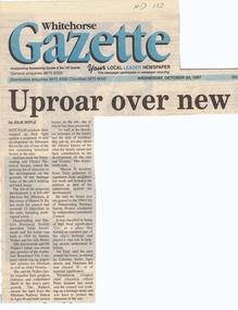
Article, Uproar over new units, 29/10/1997 12:00:00 AM
Mitcham residents and the Nunawading and District Historical SocietyMitcham residents and the Nunawading and District Historical Society have joined the growing list of objectors to a proposed 16 unit development at the corner of Mitcham Road and Meerut Street on the site of one of the few remaining historical homes in the area. The house was built in 1934 by Stanley and Helen Walker. Mr Walker's family was owner and operator of the Australian Tessellated Tile Company, an important industry for Mitcham and Victoria. The house was recognised in the 1994 City of Nunawading Heritage Survey Project and was classified as being of high local significance,Mitcham residents and the Nunawading and District Historical Societymitcham road, mitcham, meerut street, walker, stanley, helen, arrowsmith, valda, daly, peter, seamer -
 City of Greater Bendigo - Civic Collection
Administrative record - Land Sales, A. J. Mullet Government Printer et al, 1927
This type of album was made by agents auctioning and selling land.Large portfolio style album with dark green / black cloth cover bound with three large metal pins. Forty eight pages with twenty seven Department of Lands and Survey maps and newspaper clippings about land sales and auction details pasted in. Index page. Maps have handwritten notes and markings throughout in pencil and pen. Covers the County's of Gunbower and Tatchera. Includes a receipt slip with hand written notes on reverse on William Wallace & Co letterhead. city of bendigo commerce -
 Melbourne Tram Museum
Document - Report, Melbourne & Metropolitan Tramways Board (MMTB), "Section to Section trips compiled from information obtained by the Melbourne Metropolitan Transportation Study 1964 Card survey.", Mar. 1967
Report - Foolscap landscape format, red tape binding - approx. 30 pages with notes, diagrams, charts, maps showing passenger traffic for parts of each route. Titled "Section to Section trips compiled from information obtained by the Melbourne Metropolitan Transportation Study 1964 Card survey from tram and bus routes based on the Central Business area of Melbourne". Dated 3/1967. Contains a large fold out map of each route showing passenger numbers for the day.In top right hand corner "Lees" in inktrams, tramways, mmtb, tramways, melbourne, surveys, passengers, maps -
 Bendigo Military Museum
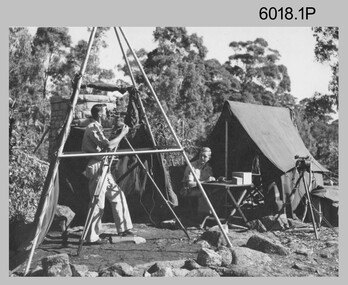
Photograph - Royal Australian Survey Corps Surveyors in the Field, 1950s to 1970s
These three photographs were most likely taken from the 1950s to the 1970s. The RASvy surveyor in each photograph was taking angular measurements with the observer recording their readings on a booking form. They were probably employed in establishing mapping and geodetic control operations or the surveyors may have been in training. Photo .1P was possibly taken at Mount Alexander in Central Victoria, a location close to Bendigo, as the stone cairn in the background of the photo appears to be identical to the cairn presently located on top of the mountain.These three photographs are of surveyors in the field undertaking observations using theodolites. The photographs were printed on photographic paper and are part of the Army Survey Regiment’s Collection. The photographs were scanned at 300 dpi. .1) - Photo, black & white, c1950s. Unidentified personnel undertaking observations with a Tavistock geodetic theodolite. .2) – Photo, colour, mounted on card, c1960s. Unidentified personnel undertaking observations with a Kern DKM2 theodolite. .3) - Photo, colour, c1970s. Unidentified personnel undertaking observations with a theodolite..1 – not annotated .2 –annotated on front “Kern DKM2, TOPO 10” royal australian survey corps, rasvy, army survey regiment, army svy regt, fortuna, asr, surveying -
 University of Melbourne, Burnley Campus Archives
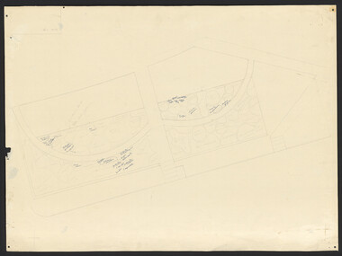
Plan, Perennial Border Spring Display, 1982-1997
(1) Tracing paper plan of bed. (2) Perennial Border Spring Display Planted 1982, plantings numbered but no names. (3) Pencil on paper, names of plants, some in pen. Area now known as the Grey Garden. Old Storage Shed cleared in 1979. (4) Tracing paper copy, VCAH Burnley Plan Survey: Perennial Border and Environs, dated 8.11.90. Scale 1:100. This might be where the Herbaceous Border is in 2012. (Also see 11.0615).gardens, shed, vcah -
 Melbourne Tram Museum
Pamphlet, VicRoads, "Bridge Road tram stop improvements", Sep. 2011
Pamphlet, printed on cream recycled paper, A3 + and A4 tear off titled "Bridge Road tram stop improvements". giving details of the Punt Road to Church St section of Bridge Road tram line. Installation of two level access tram stops to replace the existing three - Vienna style. Has details on the proposal, the background reasons, inviting people to have their say, information sessions, maps, diagrams and contact details and survey form. 2 copies held.trams, tramways, bridge rd, tram stops, vienna style stops, vicroads, disability services -
 Melbourne Tram Museum
Document - Report, East Doncaster Progress Association, "East Doncaster Progress Association - Public Transport Survey - Report", mid 1960's
Report contained within a light brown card folder, containing many loose sheets, titled "East Doncaster Progress Association - Public Transport Survey - Report". About 50 pages, printed with a spirit duplicator. Not dated, possibly mid to late 1960's. Report stapled centrally along top edge., secured by a piece of adhesive tape. Includes comparisons between MMTB bus services and possible rail services. Section 2 - copy of questions on questionnaire, includes many comments.AETA stamp on front and inside sheet and "4E8" in ink on front cover.trams, tramways, doncaster, railways, mmtb, aeta -
 Bendigo Historical Society Inc.
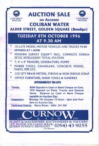
Document - IAN DYETT COLLECTION: AUCTION CATALOGUE - COLIBAN WATER
White catalogue with blue printing for a sale on the 8th October, 1996 on account of Coliban Water, Golden Square. For sale were motor vehicles and trucks, survey equipment, trailers, generators, pumps, power tools, chainsaws, concrete mixers, parts, pipe, brass meters, ferrous & non ferrous scrap, office furniture, hand tools and sundries. J. H. Curnow & Son P/L were the auctioneers. Directions how to get to the Coliban Water Depot on the back cover.business, auctioneers, j h curnow & son pty ltd, ian dyett collection - auction catalogue - coliban water, barry breen, j h curnow & son p/l -
 Bendigo Historical Society Inc.
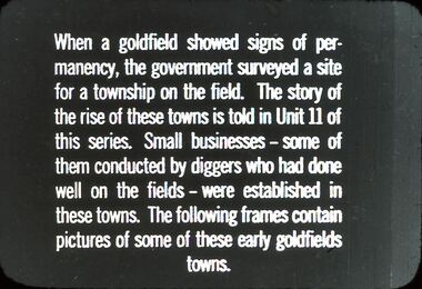
Slide - DIGGERS & MINING: THE DIGGINGS - THE DIGGERS
Diggers & Mining: The Digging - The Diggers. Slide; When a Gold field shows signs of permanency, the Government surveyed a site for a township on the field. The story of the rise of these towns is told in Unit II of this series. Smalll businesses - some of them conducted by diggers who had done well on the fields - were established in these towns. The following frames contain pictures of some of these early goldfields towns. Black and white side. Markings: 40 994.LIF:6. Used as a teaching aid.hanimounteducation, tertiary, goldfields -
Bendigo Historical Society Inc.
Map - REDESDALE : COUNTY OF BENDIGO, 25 -10-77
Map. Redesdale, County of Bendigo, County of Dalhousie, County Of Talbot, Lyell, Kimbolton, Langwornor, Spring Plains, Glenhope, Emberton, Metcalfe, Hawkestone, River Coliban, Campaspe River, Back Creek. Photo-Lithographed at the Department of Lands and Survey, Melbourne by J. Noune, 25-10-77. Compared with original plans 12-11-78 M. Kemp. J.C.Kelsh, Draughtsman April 1876. Examined by E. Downward, 5-6-77. (number 121 in map cupboard 1)J. Nounemap, bendigo, redesdale -
Bendigo Historical Society Inc.
Map - TARNAGULLA : COUNTY OF BENDIGO, 13-5-22
Map. County of Bendigo, County of Gladstone.Inglewood, Glenalbyn, Kingower, Moliagul, Waanyarra, Laaneoorie, Woodstock, Loddon River, Township of Tarnagulla, Township of Newbridge, Township of Llanelly, Dunolly to Inglewood Railway, Tarnagulla Rifle Range, Laurie Station, Bullabul Creek, Arnold Township, Arnold Railway Station. Photo-Lithographed at the Department of Lands and Survey, Melbourne by W.J. Butson, 13-5-22.Price 1/-.By authority A.J. Mullett, Government Printer, Melbourne. (number 118 in map cupboard 1)A.J. Mullett, Government Printer, Melbourne.map, bendigo, tarnagulla -
Bendigo Historical Society Inc.
Map - TARNAGULLA : COUNTY OF BENDIGO, 1959
Map. Tarnagulla, County of Bendigo, County of Gladstone, Inglewood, Glenalbyn, Kingower, Moliagul, Painswick, Waanyarra, Laanecoorie, Woodstock, Derby, Loddon River, Dunolly to Inglewood Railway, Laurie Railway Station, Township of Tarnagulla, Tarnagulla Rifle Range, Township of Llanelly, Arnold Railway Station, Bullabul Creek, Kangderaar Creek, Township of Newbridge. By authority A.C. Brooks, Government Printer, Melbourne. Drawn and reproduced at the Department of Lands and Survey, Melbourne, 1959. (number 117 in map cupboard 1)A.C. Brooks, Government Printer, Melbourne.map, bendigo, tarnagulla