Showing 4640 items matching "avenue"
-
 Canterbury History Group
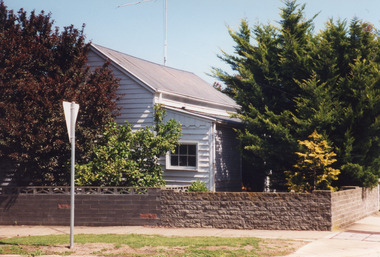
Ephemera - Stunning, contemporary 30 Alexandra Avenue, Canterbury
Real estate brochure for the sale of 30 Alexandra Avenue, Canterbury by auction on 27 June {1998 or 2009} .includes coloured photographs of the interior and the exterior, and floor and site plans.canterbury, alexandra avenue, swimming pools -
Canterbury History Group
Ephemera - "Avalon" 17 Gwenda Avenue Canterbury, [2005]
Real estate advertisement for the sale by auction of "Avalon" 17 Gwenda Avenue Canterbury on Saturday 26 November [2005] Includes coloured photograph of the exterior of the house and a floor plan, canterbury, gwenda avenue, edwardian style, avalon -
 Lakes Entrance Historical Society
Photograph - Historic House, 2000
Some residents - Nurse Stewart, midwife, 1920's and 1930's, Christina Smith, dressmaker (daughter of Nurse Stewart), Con Coveoulos, Bill Barkas and family.Colour photograph of a weatherboard cottage, corrugated iron roof, front veranda partially enclosed at 16 Barkes Avenue. Brick fence a recent addition. Lakes Entrance Victoriahouses, heritage study -
 Chelsea & District Historical Society Inc
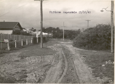
Photograph - Fifth Avenue, Aspendale, 1949
This photo is one of a collection of photos taken during Alan Niemann's - Drainage-Road Making Scheme.Black and white photo of Fifth Avenue, Aspendale. The road is unmade with grass growing on the road, is rutted, houses can be seen on the left and electricity poles are both side of the road. unmade street, aspendale, alan niemann, drainage-road making scheme, edithvale, fifth avenue -
Ringwood and District Historical Society
Plans, Education Department Victoria, Ringwood State School No 2997: Original Plans of proposed works from 1921 to 1992, 1931 to 1992
The Ringwood Primary School opened in Ringwood Street on 2nd November 1889 and eventually moved to Greenwood Avenue in 1921. These plans apply to the Greenwood Avenue location. The school closed in the 1990s.Forty two original plans of proposed works at Ringwood State School No. 2997. The dates vary from 1921, the first building, to 1992. Most of the plans are building plans for extensions or upgrades. -
 Mont De Lancey
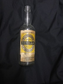
Functional object - Glass bottle, Wiltshire's Pty. Ltd, Unknown
Mr. M. W. Clements conducted a grocery store adjacent to his home near Warburton Highway, and later at a new building at the corner of Warburton Avenue and Sebire Avenue, Wandin. A tall clear glass Wiltshire's vinegar bottle with a cream, yellow and black paper label. About 24 ozs is printed at the top Wiltshire's Vinegar Made from Sugar & Malt. The manufacturer's address and details are also shown. There is an added homemade label - Clements Store Wandin, glued to the bottom of the bottle.An added label is stuck to the bottom of the bottle under the product label - 'Clements Store Wandin'bottles, food sorage containers, vinegar bottle -
 City of Ballarat Libraries
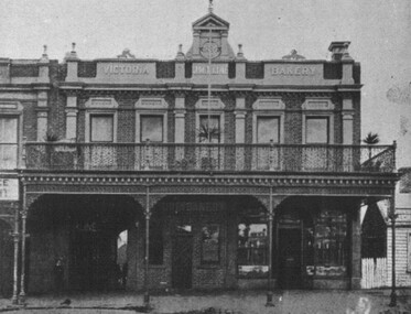
Photograph - Card Box Photographs, Advertisement for J.M. Kline Bakery. Ballarat Courier Supplement 15/12/1909
The bakery was located on Oak Avenue. j.m. kline bakery, manufacturing, building, ballarat, advertising -
 Ringwood and District Historical Society
Photograph, Jewkes pine forest in Mullum Road. Ringwood. 1958
Written next to photograph, "Jewkes pine forest in Mullum Road. Looking down from Wonga Road to Collett Avenue, 1958." -
 Ringwood and District Historical Society
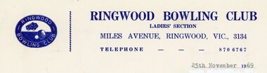
Document, Ringwood Bowls Club- Letterhead, Ringwood Bowling Club, Ladies Section, 1969
Copy of Letterhead.Ringwood Bowling Club Ladies Section Miles Avenue, Ringwood, Vic., 3134. Telephone: 870 6767. 25th November 1969 -
 Southern Sherbrooke Historical Society Inc.
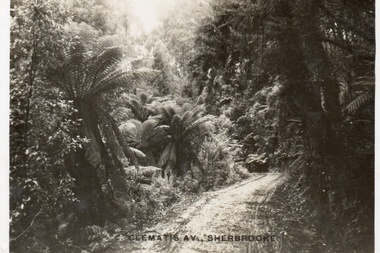
Postcard, Clematis Av, Sherbrooke
Sepia-toned postcard featuring Clematis Avenue Sherbrooke. Very heavily ferned on either side of road. Almost just a track. -
 Kew Historical Society Inc
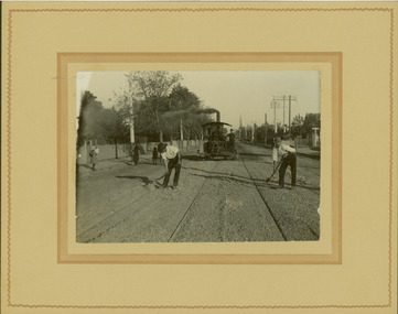
Photograph - Electric tram line construction in Cotham Road, Kew, E.J. Dower, 1913
One of a series of photographs, taken by Edgar James Dower in the second decade of the twentieth century. Born and raised in Olinda, his family later moved to Surrey Hills. He worked as an adult as a clerk in the city office of the Metropolitan Gas Company, and in his role as a 'collector', he was able to photograph scenes including the construction of tramlines and associated buildings in Kew, Hawthorn, Camberwell and Surrey Hills. Later he established a real estate agency with his brother - the E.J. Dower Real Estate Agency, Dandenong Office.The image is an historically significant record of the development of transport infrastructure which was used to connect Victorians in the first two decades of the twentieth century. This development resulted from increases in population and the consequent extension of Melbourne's suburbs. The photographs, both individually and collectively, richly detail the labour of workers and the tools and machinery used to create and extend Melbourne's tram network in the years preceding and during World War 1.Digital copy of an original mounted photograph depicting construction of a new electric tramline in Cotham Road, Kew. The photo shows workers and a steamroller. The spire of the Kew Presbyterian Church can be seen in the distance.Annotated verso: "Preparing for electric trams / Cotham Road Kew / Taken near Barrington Avenue / Taken by E.J. Dower / 1913"theme --- travelling by tram, theme -- connecting victorians by transport and communications, cotham road -- kew (vic.), trams -- kew (vic.) -
 Ringwood and District Historical Society
Document - Map, Plan of Subdivision - Part of Crown Allotments 14A & 14C, Parish of Ringwood, County of Mornington, Vol 5378 Fol 511 - 1927
Department of Lands and Survey photocopy dated 17/1/1951, page number 12308.Map includes Canterbury Road, Heathmont Road, Dickasons Road, Bennett Avenue, Orchid Street and Allens Road, Heathmont, Vic. -
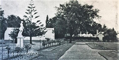 City of Ballarat Libraries
Postcard - Card Box Photographs, Keel Glasshouse and Caretaker's House, Ballarat Botanic Gardens 1929
This area is now the Prime Minister's Avenue.keep glasshouse, caretaker's house, ballarat botanic gardens, gardens, building, public, statues -
Phillip Island and District Historical Society Inc.
Photograph, 3/10/1920
This postcard is contained in an album presented to the then Governor of Victoria, The Earl of Stradbroke, by the fathers of soldiers & returned soldiers of Phillip Island, on 16/02/1923. The history of the album is noted on Reg. No 85-00Postcard of view of Thompson Avenue looking north to HMAS Australia in Western Port Bay, 3-10-1920; a gas lamp, the first cypress trees and the first motor garage.local history, photography, photographs, slides, film, hmas australia, thompson avenue, shipping, sepia photograph, cypress trees first planting -
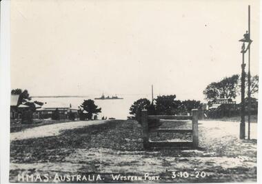 Phillip Island and District Historical Society Inc.
Photograph, 3/10/1920
One of a collection of over 400 photographs in an album commenced in 1960 and presented to the Historical Society by the Shire of Phillip IslandPhotograph looking north along Thompson Avenue from Chapel Street. HMAS Australia shown in the distant between Cowes and Sandy Point. Part of Cowes Garage also depicted.local history, photography, photographs, film maritime technology, boats, thompson avenue - hmas australia - cowes garage, black & white photograph, cowes, thompson avenue, shipping, hmas australia, cowes garage, john jenner, bryant west -
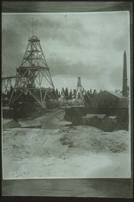 Bendigo Historical Society Inc.
Slide - ALBERT RICHARDSON COLLECTION: LANSELL'S 222 MINE
Slide.Lansell's 222 Mine. Poppet head on LH side of image, mine sheds and brick chimney called Cleopatra's Needle, on extreme RH side. Large avenue of trees in background.mine, gold, 222 mine, bendigo mines-jack hattam collection -
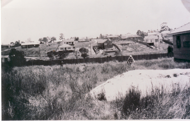 Whitehorse Historical Society Inc.
Photograph, 22 Pakenham Street, Blackburn, C.1950
Black and white photo of 22 Pakenham Street, Blackburn, looking West. Left hand corner is the dirt strip of Salisbury Avenue, Blackburn, heading up the hill to Middleborough Road. -
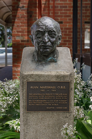 Bayside Gallery - Bayside City Council Art & Heritage Collection
Sculpture - bust, George Luke, Alan Marshall, 1985
Alan Marshall (1902-1984) was an Australian writer, storyteller, social documenter and author of 'I Can Jump Puddles'. He lived for many years in Sandringham. This work was commissioned by Sandringham Council and unveiled in May 1985 at the opening of the new Sandringham library.George Luke, Alan Marshall 1985, bronze. Bayside City Council Art and Heritage Collection. Commissioned 1985Cast bronze head of Alan Marshall. The head is mounted on a cement pedestal with a bronze plaque with inscription at the front. Located at Sandringham Library, Corner Waltham Street and Chalmers Avenue, Sandringham.alan marshall, george luke, scultpure, portrait, bust, sandringham, library, writer, social documenter, australian author -
Kew Historical Society Inc
Archive (Sub-series) - Subject File, Kew Historical Society, HOLT, Dame Zara, 1968
Various partiesReference, Research, InformationSecondary Values (KHS Imposed Order)The subject file contains Part 2 of a newspaper article, written by Dame Zara Holt, published in the Herald Sun in 1968. The article records aspects of her upbringing in 17 Ridgeway Avenue and at school at Ruyton.dame zara holt, 17 ridgeway avenue - kew (vic), herbert dickens, violet dickens, ruyton girls school - former studentsdame zara holt, 17 ridgeway avenue - kew (vic), herbert dickens, violet dickens, ruyton girls school - former students -
Canterbury History Group
Ephemera - Entertaining will be a delight!, [2004]
Real estate advertisement for the sale by auction of 30 Monomeath Avenue Canterbury on Saturday 6 November [2004]. Includes coloured photographs of the interior and exterior of the house and floor and site plans.canterbury, monomeath avenue, swimming pools, peacock family -
Canterbury History Group
Ephemera - 32 Victoria Avenue, Canterbury, [1999 or 2004]
Real estate advertrisement for the sale by auction of 32 Victoria Avenue Canterbury on Saturday 4 December [1999 or 2004]. Includes a coloured photograph of the exterior of the house and floor and site plans. -
Canterbury History Group
Ephemera - Faversham Mews - stunnning open plan living, 1/02/2011 12:00:00 AM
Real estate advertisement from the Weekly Review for the auction of 4/43 Faversham Avenue , Faversham Mews , Canterbury on the 26 February 2011. Includes coloured photographs of the interior and exterior.canterbury, faversham mews, faversham road, townhouses -
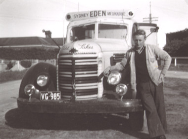 Lakes Entrance Historical Society
Photograph - Hancock Trucking, Charlie Hancock Jnr, 1950 c
Black and white photograph showing Charlie Hancock Jnr standing by a truck used to transport fish taken opposite Rosemont Guest House Barkes Avenue Lakes Entrance Victoriatransport, fishing -
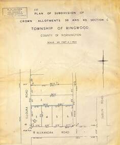 Ringwood and District Historical Society
Map - Plan of Subdivision, Part of Crown Allotments 39 and 40 Section C, Township of Ringwood, County of Mornington - (Undated - circa 1930s)
Copy of land title map on light cardboard backing showing layout and size of 6 allotments in Illoura Road (later Illoura Avenue) and Alexandra Road, Ringwood East, Victoria. Rubber stamp imprint in top left corner - D.H. Oliver, Civil Engineer & Licensed Surveyor, Bellevue Street Lilydale, Phone Lilydale 91. -
 Kew Historical Society Inc
Plan - Subdivision Plan, H C Crouch, Old Golf Links Estate, 1930s
The land in North Kew between the Outer Circle Railway and the River Yarra was released in sections. This release included 80 lots. Most of this area was released during the Depression years in the early 1930s.Subdivision plans are historically important documents used as evidence of the growth of suburbs in Australia. They frequently provide information about when the land was sold on which a built structure was subsequently constructed as well as evidence relating to surveyors and real estate and financial agents. The numerous subdivision plans in the Kew Historical Society's collection represent working documents, ranging from the initial sketches made in planning a subdivision to printed plans on which auctioneers or agents listed the prices for which individual lots were sold. In a number of cases, the reverse of a subdivision plan in the collection includes a photograph of a house that was also for sale by the agent. These photographs provide significant heritage information relating house design and decoration, fencing and household gardens.One part of a massive subdivision of the Old Golf Links Estate in North Kew of 80 allotments bordering Sutherland Avenue, Ramsay Avenue, Belford Road, Beresford Street and Coleman Avenue. Inset on the plan at the top left, the route of the Outer Circle Railway is clearly marked. The Kew Golf Links is identified in its current location. The land on which Greenacres Golf Club was to be constructed is at this time marked as ‘Recreation Ground’. The ‘new bridge’ over the Yarra at Burke Road is also marked on the inset map. The Plan identifies the surveyor (sic) H.C. Crouch BCE MVIS, 443 Little Collins St., Melbourne. The date of the subdivision auction sale in identified as Saturday September 25th at three o'clock.Annotations: "E" top left. "Golf Links" top right. Lots 73-76 ticked and listed as "6" poundssubdivisions -- kew (vic.), old golf links estate -
 Phillip Island and District Historical Society Inc.
Photograph, 1940's
One of a collection of photographs purchased from Photo First, Thompson Avenue, Cowes, when it closed down in June 2014. Photograph of The Esplancade near corner of Bass Avenue. Tennis Courts belonging to Yackatoon or Continental.Large Black & White photograph of The Esplanade, Cowes showing cars, tennis courts and Moreton Bay fig in the foreground.the esplanade cowes, moreton bay fig, photo first phillip island -
 Phillip Island and District Historical Society Inc.
Photograph, 1940's
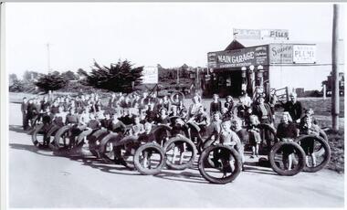
RACV Garage in Thompson Avenue. "Thompson's Garage".Black & White photograph of community of Cowes with tyres collected for the war effort in front of Thompson's Main Garage.Tyres collected for the war effort - 1940'swar effort collection, thompson's garage cowes phillip island, sue payne -
 Halls Gap & Grampians Historical Society
Photograph - Sepia
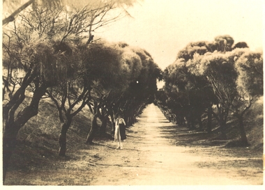
"Wonderland Avenue, Grampians" printed in white on photograph.Rocky formations. Mountain range in the background. Straggly trees in foreground beside large boulders.scenery, wonderland range -
 Port Fairy Historical Society Museum and Archives
Postcard
Road to the East beach probably Bourne AvenueRoad to the beach Port Fairyeast beach, bourne avenue, tea teee -
 Ringwood and District Historical Society
Plan - Proposed Ringwood East Railway Station, VR Ringwood-Croydon (Dublin Road) - 1923
Technical drawing of "Proposed Station At 16Mls 38Chs 89Lks (Dublin Road)" inluding boundary line, red shaded platform with station buildings, and green shaded possible future "up" track. Surrounding streets include Dublin Road, Patterson Street, and subsequent hand-written additions of Railway Avenue, Lawrence Grove, Stanley Avenue, Wenwood Street, and Lois Street. Land title details of Patterson Street properties mainly illegible.Scale: 40'=1". Possible future (platform) extension for 8 car trains (and) extension for 10 car trains.