Showing 12792 items
matching on-off
-
 Ringwood and District Historical Society
Photographs, 1979-80 MMBW pipe line project at Hubbard Reserve, North Ringwood � The work on sewer line from 29-39 Burlock Avenue
... Ringwood � The work on sewer line from 29-39 Burlock Avenue ...Part of a 43-photo record of the MMBW�s engineering feat in drilling a 12 inch pipe line up to 40 feet deep through rock hardened by volcanic action associated with geological fault that occurs along the line. The work took place from October 1979 to May 1980 on the southern boundary of Hubbard Reserve, North Ringwood. The collection was presented to the Ringwood Historical Research Group by J Clarke on 9th June 1980.E561 N11 3 March 1980 A43 The work on sewer line from 29-39 Burlock Avenue. Lundy-Clarke's place on sky-line. -
 Ringwood and District Historical Society
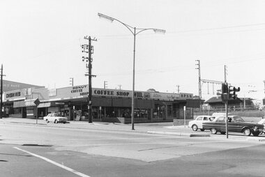
Photograph, Shops on the south side of Maroondah Highway east of Wantirna Road, Ringwood - 1969
... Shops on the south side of Maroondah Highway east of ...Shops south side of Maroondah Hwy Cheshires book shopWritten on backing sheet, "1969". -
 Ringwood and District Historical Society
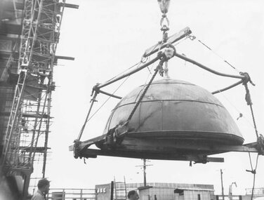
Photograph, Ringwood Clocktower dome retained from Warrandyte Road location being placed on new tower at Wantirna Road site - 1967
... location being placed on new tower at Wantirna Road site - 1967. ...B&W photograph. See also VC 2397 for other images of the clocktower under constructionWritten on backing sheet, "Dome of old tower being placed on new one - 1967". -
 Ringwood and District Historical Society
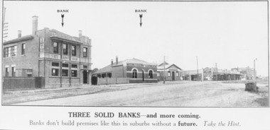
Photograph, 1924 Land Sale brochure image of Maroondah Highway, Ringwood, showing State Savings Bank, Bank of Victoria, Ringwood Hall on the corner of Melbourne Street, then shops and double storey Block Building including Coffee Palace and E.S. & A. Bank Chambers
... Hall on the corner of Melbourne Street, then shops and double ...Typed below one copy, "Three solid banks - and more coming. Banks don't build premises like this in suburbs without a future. Take a Hint". Written on back of this photograph, "State Savings Bank, Bank of Victoria, Mechanics Institute, E.S. & A. in 2 storey Bld. 1924." Written on backing sheet of other photograph, "1924, SSB Bank, Bank of Victoria, Ringwood Hall, shops then Coffee Palace and E.S. & A. Bank". -
 Ringwood and District Historical Society
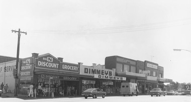
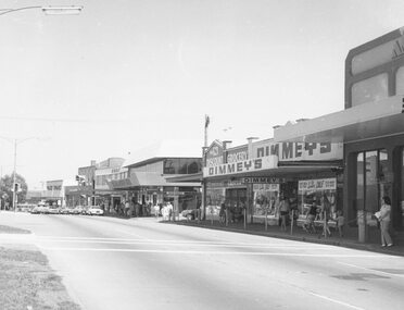
Photograph, Shops on the north-east corner of Melbourne Street and Maroondah Highway, Ringwood - c.1970
... Shops on the north-east corner of Melbourne Street and ...Black and white photograph of shops. Shops in photograph are "Big N Discount Grocery, Dimmey's, ANZ Bank, Sound and Camera" Safeway roof can be seen in the distance. -
 Ringwood and District Historical Society
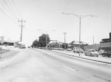
Photograph, Maroondah Highway, Ringwood, viewed from Warrandyte Road towards Eastland - 1974. Bus and taxi access road to railway station on left
... station on left. ...Written on backing sheet, "Maroondah Highway near corner Warrandyte Rd., 1974". -
 Ringwood and District Historical Society
Photograph, Maroondah Highway, Ringwood, viewed from Warrandyte Road - 1974. Bus and taxi access road to railway station on left
... - 1974. Bus and taxi access road to railway station on left. ...Written on backing sheet, "Maroondah Highway, 1976 - West from Warrandyte Rd. ext." -
 Ringwood and District Historical Society
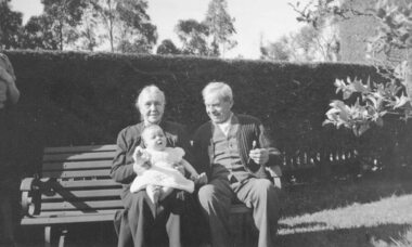
Photograph, Mr. and Mrs. Springett on a garden seat - Ringwood, circa 1930, C. 1930
... Mr. and Mrs. Springett on a garden seat - Ringwood, circa ...Photograph of Mr. and Mrs. Springett on a garden seat. B&W. Mrs Springett holding a child. Clipped hedge behind. Woman standing on LHS, half in the photo. +Additional Keywords: Springett, Mr & MrsWritten on back of photograph, "From Mr. and Mrs. Springett". (No date or other information) -
 Ringwood and District Historical Society
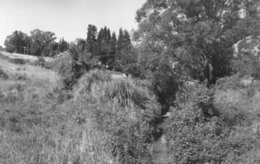
Photograph, Mullum Mullum Creek from footbridge on Munro St., Ringwood, looking east - 1969, 1970
... Mullum Mullum Creek from footbridge on Munro St., Ringwood ...Typed below photograph, "Mullum Creek from footbridge on Munro St. Looking east, 1969". Written on backing sheet, "Mullum Creek looking east at footbridge at Munro St. 1970. Pampas grass was planted years ago by Mrs. Blood".(To be verified in regards to planter). +Additional Keywords: Brown, Mrs / Blood, MrsTyped below photograph, "Mullum Creek from footbridge on Munro St. Looking east, 1969". Written on backing sheet, "Mullum Creek looking east at footbridge at Munro St. 1970. Pampas grass was planted years ago by Mrs. Brown or Mrs Blood". -
 Ringwood and District Historical Society
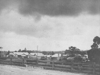
Photograph, Maroondah Highway Central, Ringwood. View of buildings on Maroondah Highway Ringwood, taken overlooking railway yard from Station St. and Greenwood Ave., 1914
... Maroondah Highway Central, Ringwood. View of buildings on ...Black and white photograph (2 copies)Typed below one photograph: "View of buildings on Maroondah Highway taken overlooking railway yard from Station St. and Greenwood Ave. 1914". Written on rear of backing sheet: "View of township taken from near the Methodist Church showing railway yards, Ringwood Hall and Methodist Church Hall. Methodist Church closed 1915. Photo taken from new one (Cnr. Greenwood Ave.)". -
 Ringwood and District Historical Society
Photograph, Maroondah Highway Central, Ringwood. Shops on site of old Town Hall, corner of Melbourne Street, 1972
... Maroondah Highway Central, Ringwood. Shops on site of old ...Black and white photograph (2 copies) Written on rear of backing sheet: "Shops on site of old Town Hall. Cnr. Melbourne St. 1972" -
 Ringwood and District Historical Society
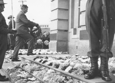
Photograph, Clocktower re-opening on corner Maroondah Highway and Wantirna Road, Ringwood - December 1967
... Clocktower re-opening on corner Maroondah Highway and ...Mr. Bill Kelly, R.S.L., laying a wreath at Ringwood Clocktower opening.Typed below photograph, 'Mr. Bill Kelly, R.S.L. at new position of clocktower'. Catalogue card reads, 'Clocktower re-opening. Mr. Bill Kelly laying wreath (R.S.L.) at clock in new position corner Maroondah Highway and Wantirna Road'. -
 Ringwood and District Historical Society
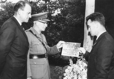
Photograph, Major General Beavis with new plaque for Memorial Tree on 10th anniversary of planting at North Ringwood State School, Oban Road, North Ringwood - 1965
... Major General Beavis with new plaque for Memorial Tree on ...Typed below photograph, 'Major General Beavis receiving new plaque for Memorial Tree North Ringwood State School grounds. Tree originally planted in 1955 in sand brought from Gallipoli in 1936 when R.A. Pullin was serving in H.M.A.S. Australia. The visit commemorated the 20th anniversary of the landing'. -
 Ringwood and District Historical Society
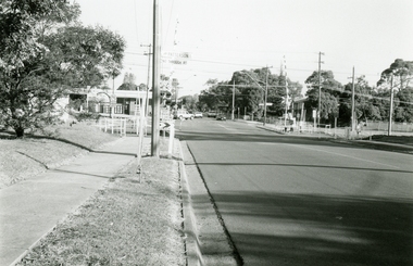
Photographs, Ringwood East Railway Crossing on Dublin Road in 1999
... Ringwood East Railway Crossing on Dublin Road in 1999 ... -
 Ringwood and District Historical Society
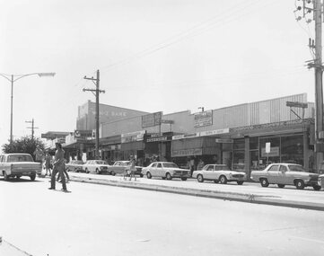
Photograph, Central shopping strip on the south side of Maroondah Hwy, Ringwood - 1970
... Central shopping strip on the south side of Maroondah Hwy ...1970, ANZ bank at 116 Maroondah Highway, 2 copiesBacking sheet reads, "Shops opposite (old) Town Hall and Midway Arcade". -
 Ringwood and District Historical Society
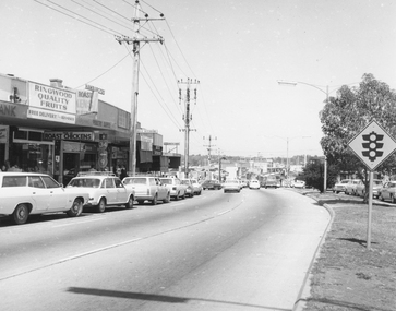
Photograph, Westerly view of approach to Wantirna Road showing shops on southern side of Maroondah Highway, Ringwood - 1972
... Westerly view of approach to Wantirna Road showing shops on ...Written on backing sheet, "Shops opposite old town hall - looking west - 1972". -
 Ringwood and District Historical Society
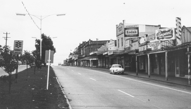
Photograph, Maroondah Highway, Ringwood, looking west from Warrandyte Road - 1965. (Flag at half-mast on town hall and lack of traffic indicates possibly ANZAC Day public holiday.)
... Road - 1965. (Flag at half-mast on town hall and lack of ...Written on backing sheet, "Main Street, looking west from near corner of Warrandyte Rd. 1966". -
 Ringwood and District Historical Society
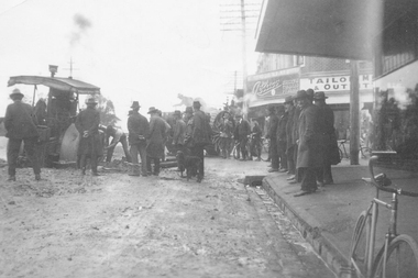
Photograph, Bogged on Maroondah Highway
... Bogged on Maroondah Highway ...Black and white photograph of work on roadway. Bogged equipment with men standing looking on.Typed below photograph, "Bogged on Maroondah Highway opposite station. Circa 1930". -
 Ringwood and District Historical Society
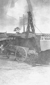
Photograph, Roadworks on Maroondah Highway at corner Warrandyte Rd
... Roadworks on Maroondah Highway at corner Warrandyte Rd. ...Black and white photograph of horse and wagon. Scoop dumping soil into wagon.Typed below photograph, "Roadworks on Maroondah Highway at corner Warrandyte Rd." -
 Ringwood and District Historical Society
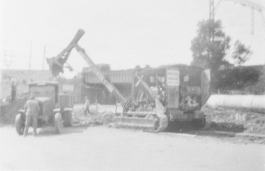
Photograph, Roadworks on Maroondah Highway
... Roadworks on Maroondah Highway. ...Black and white photograph of roadworks. Railway bridge in background.Typed below photograph, "Roadworks on Maroondah Highway circa 1930 Warrandyte Rd. subway behind"/ -
 Ringwood and District Historical Society
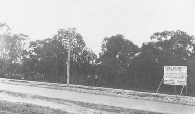
Photograph, Trees lining north side of Maroondah Highway between New Street and Ringwood Street, Ringwood - 1926. Auction Sale sign is shown on the eventual Holeproof factory site, later street numbered around 103 Maroondah Highway, Ringwood
... is shown on the eventual Holeproof factory site, later street ...Catalogue card reads, "Public Auction 1926. Saturday 29th May 1926. Holeproof factory once stood on this site. Billy Guyatt's discount store now occupies the site. (3 copies)". -
 Ringwood and District Historical Society
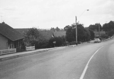
Photograph, South side of Bedford Road, Ringwood East, taken from outside shops on the corner of Illoura Avenue - 1/9/1974
... outside shops on the corner of Illoura Avenue - 1/9/1974. ...Written on back of photograph, "Bedford Rd. looking at south side towards east from outside shops cnr. Illoura Ave. (As in brochure)" -
 Ringwood and District Historical Society
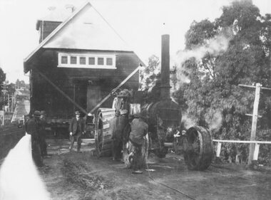
Photograph, C of E jambed on bridge over Mullum Creek, W'dyte Rd. Ringwood 1924
... C of E jambed on bridge over Mullum Creek, W'dyte Rd ...Written on back of photograph, "C of E jambed on bridge over Mullum Creek, W'dyte Rd. 1924." Typed below another copy: "Moving Church of England, Ringwood. Stuck on bridge over Mullum Creek in Warrandyte Rd. 1924". Written on backing sheet, "Church of England being moved from C/r Pratt Street and Maroondah H'way to rear post office via Warrandyte Rd., Reynolds Av. and Ringwood Street." -
 Ringwood and District Historical Society
Photograph, Images used for land sale promotion of Coleman's Heathmont Estate, looking across the estate from Canterbury Road, Heathmont towards Bedford Road on the far boundary. Sale 15/12/1923 by Public Auction
... towards Bedford Road on the far boundary. Sale 15/12/1923 by ...Catalogue card reads, "Coleman's Heathmont Estate 1923. 15/12/1923. Looking across the estate from Canterbury Rd. Bedford Rd. is seen on the far boundary." -
 Ringwood and District Historical Society
Photograph, Ringwood Church of England stuck on Warrandyte Rd. bridge over Mullum Creek whilst being removed - 1924
... Ringwood Church of England stuck on Warrandyte Rd. bridge ...Black and white photograph of building, steam-roller in front.Written on backing sheet, "C of E stuck on W'dyte Rd. bridge over Mullum Ck. whilst being taken from C.r Main & Pratt Sts. to new site in Ringwood St. 1924" -
 Ringwood and District Historical Society
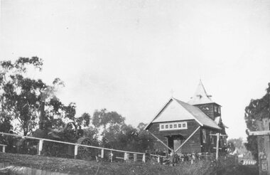
Photograph, Ringwood Methodist Church on site at Cnr. Melbourne St. and Whitehorse Rd 1904
... Ringwood Methodist Church on site at Cnr. Melbourne St. and ...Written on backing sheet, "Methodist Church on site at Cnr. Melbourne St. and Whitehorse Rd. On its removal to Greenwood Ave. Mr. J.B. McAlpin built shops on this site - land (Dimmey's) including his own estate agency." One photograph claimed church was moved to Greenwood Ave in 1916. Photograph taken in 1904. Another photograph states that the photograph is of the Methodist Church and Sunday School. Inserted in the sleeve of one of the photographs are two small postcard photographs that state they are, "Methodist Church in Main Street, Ringwood opposite railway station. See Mechanics Institute where Town Hall now stands - c1910. Photo by L. F. East". -
 Ringwood and District Historical Society
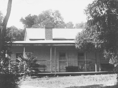
Photograph, Original home on which Ringwood High School now stands, Bedford Road
... Original home on which Ringwood High School now stands ...Written on back of photographs, "This house is said to be the original home on which the High School, Bedford Road now stands. Owner of the orchard was Mrs. Theo Anderson, landscape painting artist. Original owner of land was ? Williams". Other copy says artist was, "Theodosia Anderson". -
 Ringwood and District Historical Society
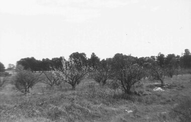
Photograph, Herman Pump's orchard and home Heathmont - 1923 - in vicinity of Royal Avenue. House on Canterbury Road, later site of Uniting Church
... vicinity of Royal Avenue. House on Canterbury Road, later site of ...Black and white photograph of orchard. House in top left of photograph.Typed on backing sheet below photograph, "Herman Pump's orchard and home Heathmont - 1923 - in vicinity of Royal Avenue. House on Canterbury Road, now site of Uniting Church". -
 Ringwood and District Historical Society
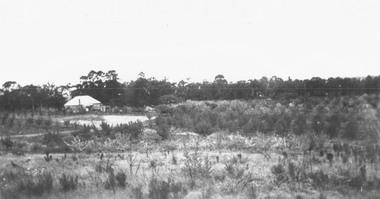
Photograph, Remains of Frazer's orchard, North Ringwood. State school on left - 1972
... on left - 1972. ...Updated Information from Bruce Frazer: This is Frazer's (not "Fraser") orchard, sold to A.V. Jennings Co. For housing development c1970. Address was "Alkoomi", Oban Rd. North Ringwood. State School 4120 was enclosed on its north & east sides by the orchard. Owned by Harold & Sylvia Frazer, 12 acres, growing mainly cherries plus plums & lemons. Photo was taken from neighbouring apple orchard (Williams) & shows street construction in the middle distance.Written on back of photograph, "Remains of [Fraser's] orchard. State school on left". -
 Ringwood and District Historical Society
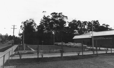
Photograph, Six photos taken around new library site on opening morning - 2nd May 1970
... Six photos taken around new library site on opening morning ...Written on back of photograph, "Opening morning".