Showing 28491 items
matching street street
-
 Wodonga & District Historical Society Inc
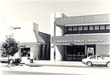
Photograph - Codling Collection 01 - High Street East - ANZ Bank, Commonwealth Banking Corporation, 1980s
... Codling Collection 01 - High Street East - ANZ Bank...Codling Collection 01 - High Street East - ANZ Bank...Eastern side of High Street, Wodonga - High Street East... of High Street, Wodonga - High Street East - ANZ Bank ...Miss Olive Codling was a Foundation Member and a Life Member of the Wodonga Historical Society. Many of her prize-winning photos are held in the Society Collection. She also held a range of roles and committee positions in a wide range of Wodonga community organisations. These included the Horticultural Society, the Wodonga Arts Council, the Wodonga Camera Club and the Wodonga Lapidary Club. This photo collection is significant as it documents how the businesses and buildings in Wodonga have evolved and contributed to community throughout the 20th century.Eastern side of High Street, Wodonga - High Street East - ANZ Bank, Commonwealth Banking Corporation. Both of these banks have now moved to the opposite side of High Street as part of the redevelopment of the city centre. At the time of this entry in 2021 the Commonwealth Bank pictured is the office of Senator The Hon. Bridget McKenzie and the ANZ Bank building is vacant.wodonga businesses, high st wodonga, commonwealth bank wodonga, anz bank wodonga -
 Ringwood and District Historical Society
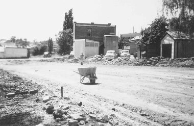
Photograph, Lane from Adelaide St Ringwood (widening) and Jack Orr's shed 1958
... of paper): SS0182a: "Lane from Adelaide Street to Melbourne Street... Street to Melbourne Street being widened to form street." SS0182b ...Written next to photographs (mounted on single sheet of paper): SS0182a: "Lane from Adelaide Street to Melbourne Street being widened to form street." SS0182b: "Shed on left used by Jack Orr for making steel cloths hoists. Nov. 1958" -
 Bendigo Historical Society Inc.
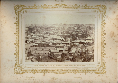
Photograph - VIEWS OF BENDIGO: LOOKING WEST FROM ST. PAUL'S CHURCH, 1875 copy,1970
... ',' Mitchell Street, Forest Street in the distance',' View Point, View... Inc. History House 11 Mackenzie Street Bendigo goldfields ...Sepia photo on cream board. Shows westwards view over Bendigo from St. Pauls church tower. Inscription: Above image, 'Views of Bendigo|No.45.'. Below, 'View from St. Paul's church tower looking Westward.', 'N.J.Caire Photo, Sandhurst'. Bottom, 'Casey & Wenborn's Print Forbes & Holmes, Agents',' Mitchell Street, Forest Street in the distance',' View Point, View Street, Charing Cross with lamp in the centre. Knipe's Castle on the hill'. On Back, RHSV stamp, Bendigo Branch '1959|70' Nicholas CaireN.J.Caireplace, bendigo, view west from st.pauls church, see: 'views of bendigo' by n.j.caire -
 Kew Historical Society Inc
Plan, Melbourne & Metropolitan Board of Works : Borough of Kew : Detail Plan No.1572, 1905
... and environmental features. Each plan covers one or two street blocks... by Barkers Road, Wrixon Street, Edgevale Road and Fitzwilliam Street... features. Each plan covers one or two street blocks (roughly six ...The Melbourne and Metropolitan Board of Works (MMBW) plans were produced from the 1890s to the 1950s. They were crucial to the design and development of Melbourne's sewerage and drainage system. The plans, at a scale of 40 feet to 1 inch (1:480), provide a detailed historical record of Melbourne streetscapes and environmental features. Each plan covers one or two street blocks (roughly six streets), showing details of buildings, including garden layouts and ownership boundaries, and features such as laneways, drains, bridges, parks, municipal boundaries and other prominent landmarks as they existed at the time each plan was produced. (Source: State Library of Victoria)This plan forms part of a large group of MMBW plans and maps that was donated to the Society by the Mr Poulter, City Engineer of the City of Kew in 1989. Within this collection, thirty-five hand-coloured plans, backed with linen, are of statewide significance as they include annotations that provide details of construction materials used in buildings in the first decade of the 20th century as well as additional information about land ownership and usage. The copies in the Public Record Office Victoria and the State Library of Victoria are monochrome versions which do not denote building materials so that the maps in this collection are invaluable and unique tools for researchers and heritage consultants. A number of the plans are not held in the collection of the State Library of Victoria so they have the additional attribute of rarity.Original survey plan, issued by the MMBW to a contractor with responsibility for constructing sewers in the area identified on the plan within the Borough of Kew. The plan was at some stage hand-coloured, possibly by the contractor, but more likely by officers working in the Engineering Department of the Borough and later Town, then City of Kew. The hand-coloured sections of buildings on the plan were used to denote masonry or brick constructions (pink), weatherboard constructions (yellow), and public buildings (grey). Plan No. 1572 represents the built environment bordered by Barkers Road, Wrixon Street, Edgevale Road and Fitzwilliam Street. Other streets identified on the plan include Stansell Street. Plan 1572 shows that by 1903-05, there was only patchy development in this area of Kew, mainly on Edgevale Road and Fitzwilliam Street. Only two named houses are identified: the quaintly named ‘Tweed Cottage’, and ‘Mendip’. The earliest reference to Treed Cottage in Australian newspapers is to the death of Walter Thompson, aged 74 who was a resident there in 1885. His youngest daughter was to die there in 1908. Mendip to the north of Tweed Cottage was owned by Henry Thompson; he was to die in 1901; his wife in 1932. At this period of time, Malin Street and Clivedon Court did not extend to Barkers Road.melbourne and metropolitan board of works, detail plans, mmbw 1572, cartography -
 Federation University Historical Collection
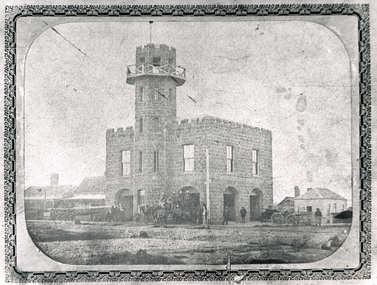
Photograph, Solomon and Bardwell, Western Fire Brigade Ballarat, c1861, c1861
... Brigade on the corner of Sturt Street and Raglan (north) Street...Sturt Street, Ballarat, Victoria, Australia... West Fire Brigade on the corner of Sturt Street and Raglan ...The former Ballarat West Fire Brigade is one of the oldest fire stations still standing in Victoria. Black and white photograph showing a double storey bluestone building with tower known as the Ballarat West Fire Brigade on the corner of Sturt Street and Raglan (north) Street. A number of fire carriages and uniformed men are evident in front of the fire station. ballarat west fire brigade, western fire brigade, bluestone -
 Bendigo Historical Society Inc.
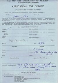
Document - CASTLEMAINE GAS COMPANY COLLECTION: APPLICATION FOR SERVICE, 16/03/1960
... for installation of gas cooker at 7th lot Osborne Street East at Neale... Inc. History House 11 Mackenzie Street Bendigo goldfields ...Gas and Fuel Corporation of Victoria - Application for service from main to position of meter. Application for installation of gas cooker at 7th lot Osborne Street East at Neale Street, Owner F. O' Connoll date 16/03/1960.business, retail, gas and fuel -
 Bendigo Historical Society Inc.
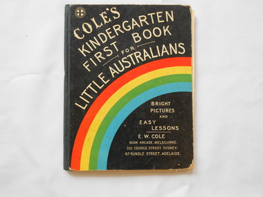
Book - COLE'S KINDERGARTEN FIRST BOOK
... Street Sydney, 67 Rundle Street Adelaide. Printed in Glasgow... Inc. History House 11 Mackenzie Street Bendigo goldfields Book ...Book title "Cole's Kindergarten first book for little Australians"96 pages. E. W. Cole book arcadeMelbourne. 333 George Street Sydney, 67 Rundle Street Adelaide. Printed in Glasgow. Illustrated in colour and blacxk and white. -
 Lakes Entrance Historical Society
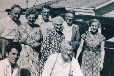
Photograph - Bell Family, 1955c
... 1950s, taken at rear of house on Church Street 2nd from Myers... on Church Street 2nd from Myers Street corner, Northside. Lakes ...Black and white photograph of eight people associated with the Bell family who managed the Victoria House guesthouse in early 1950s, taken at rear of house on Church Street 2nd from Myers Street corner, Northside. Lakes Entrance Victoriaclothing, genealogy -
 Warrnambool and District Historical Society Inc.
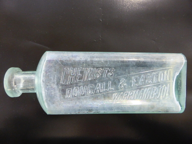
Bottle, Dougall & Easton Chemisy, Early 20th century
... Streets (102 Liebig Street) and it was established in 1913... Street (south of Merri St) Warrnambool great-ocean-road ...This bottle was used by the Warrnambool chemists, Dougall and Easton. Their pharmacy was at the corner of Liebig and Koroit Streets (102 Liebig Street) and it was established in 1913. In March 1923 they leased the business to Leonard Eason when Mr Easton opened a pharmacy business in East Camberwell in Melbourne. This bottle is of interest as it is one of the few items in our collection that is associated with the early 20th century Warrnambool chemists, Dougall & Easton. This is a glass bottle with a rectangular body with rounded sides, a circular-shaped neck and a moulded circular top with a glass stopper. The name of the chemist is embossed in an indent on the front of the bottle. The bottle is empty and the inside of the bottle is slightly discoloured. On base: ‘M’ On front: ‘3 V111’ ‘Chemists, Dougall & Easton, Warrnambool’ warrnambool chemists, history of warrnambool, dougall & easton, -
 Eltham District Historical Society Inc
Slide, Construction of Eltham Town Park, 22 Feb 1974
... Susan Street... from Susan Street and the Shell Service Station which... from Susan Street and the Shell Service Station which ...Construction of Eltham Town Park, later renamed Alistair Knox Park. In the distance can be seen the Eltham Tip accessed from Susan Street and the Shell Service Station which was situated on the corner of Susan Street and Bridge Street, now the site of Bunnings35 mm colour positive transparency Mount - Agfacolor Service (Blue)alistair knox park, eltham town park, eltham tip, shell service station, susan street -
 Clunes Museum
Document, MINUTES FOR PUBLIC MEETING HELD IN THE TOWN HALL CLUNES ON 23/2/1971, 23/02/1971
... AND CONSTRUCTION OF A SCENIC TOURISE ROAD FROM ANGUS STREET TO FRASER...Clunes Museum 36 Fraser Street Clunes goldfields ...THIS PUBLIC MEETING WAS TO CONSIDER THE FOLLOWING; HOLDING OF A "BACK TO CLUNES", CONSTRUCTION OF A CARAVAN PARK AND CONSTRUCTION OF A SCENIC TOURISE ROAD FROM ANGUS STREET TO FRASER STREET VIA "THE ROCKS" THIS RESULTED IN THE ELECTION OF A "BACK TO CLUNES" COMMITTEE AND THE" SCENIC ROAD AND CARAVAN PARK COMMITTEE".2 X FOOLSCAP PAGES OF THE COPY OF MINUTES HELD IN THE TOWN HALL, CLUNES ON 23/2/1971local history, local government, council, events and celebrations, back to clunes, scenic road and caravan park committee -
 Stawell Historical Society Inc
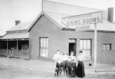
Photograph, Schneider's boarding house cnr. Victoria & Georges Street. Stawell c 1901
... Schneider's boarding house cnr. Victoria & Georges Street... building Corner of Victoria Street and St Georges Street. Building... building Corner of Victoria Street and St Georges Street. Building ...Schneider’s Boarding House with family group outside building Corner of Victoria Street and St Georges Street. Building was also the Victorian Coffee Palace, then the Doll Factory.Two photos of the Schneider Family outside their boarding house and beside a sign Dinning Rooms, on the corner of Victoria St. & George St. Stawell. c 1901. The small photo is a black & white photo, the other a enlarged print of the same photo in a purply colour.Written on the enlarged print, beside the image is the wording "When Peter died in 1901 Isabella was left to support fer family. Charles was only one year old so Isabella ran a Boarding House at the corner of Victoria St. & George St. Stawell".stawell business -
 Stawell Historical Society Inc
Photograph, Barnes and Scallan Streets intersection looking towards cemetery with Mr H Crouch's Undertaker Premises on the corner c1880's
... Main Street Barnes and Scallan Streets intersection looking... grampians Main Street Barnes and Scallan Streets intersection ...Main Street Barnes and Scallan Streets intersection looking towards cemetery. H Crouch Undertaker on corner. Primary School 502 obscured by trees. 1880'sVictorian Views. C. Herbert, Photo. Stawell 1878stawell cemetry road -
 The Beechworth Burke Museum Research Collection
Photograph (Series) - Index Card, George Tibbits, High St, Beechworth, 1976
... Property - High Street, Beechworth - from Camp Street... Street Beechworth Property - High Street, Beechworth - from Camp ...George Tibbits, University of Melbourne. Faculty of Architecture, Building and Town & Regional PlanningIndex system that support the research for Beechworth : historical reconstruction / [by] George Tibbits ... [et al]Arranged by street names of BeechworthEach index card includes: street name and number of property, image of property, allotment and section number, property owners and dates of ownership, description of the property according to rate records, property floor plan with dimensions.beechworth, george tibbitsbeechworth, george tibbits -
 Ringwood and District Historical Society
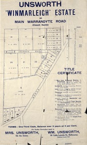
Flyer, Land Sale Advertisement - Unsworth Winmarleigh Estate, Ringwood, Victoria - circa 1912
... & Warrandyte Road), Unsworth Road, Through Road, Cross Street, and John... Road, Cross Street, and John Street. Contacts - Mrs Unsworth ...Advertisement and attachment for subdivision of land adjoining Warrandyte Road coach route in North Ringwood, with map showing layout of subdivision, summary of local features and services, and terms of sale. Subdivision includes Wonga Road (later Loughnan Road & Warrandyte Road), Unsworth Road, Through Road, Cross Street, and John Street. Contacts - Mrs Unsworth on the Estate or W.M. Unsworth, 58 Little Latrobe Street, Melbourne, Telephone Central 7207. -
 Greensborough Historical Society
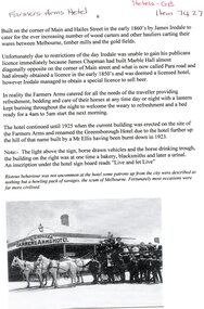
Article, Farmers Arms Hotel, 2012
... main street greensborough...The Farmers Arms Hotel stood on the corner of Main Street... on the corner of Main Street and Hailes Street Greensborough from ...The Farmers Arms Hotel stood on the corner of Main Street and Hailes Street Greensborough from the early 1860s until 1925 when the current building on this site was erected and named the Greensborough Hotel after the establishment of that name, further up the hill, was burnt down in 1923. 1 page, text and black and white imagefarmers arms hotel, greensborough hotel, main street greensborough -
 Stawell Historical Society Inc
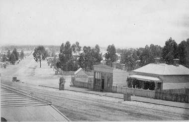
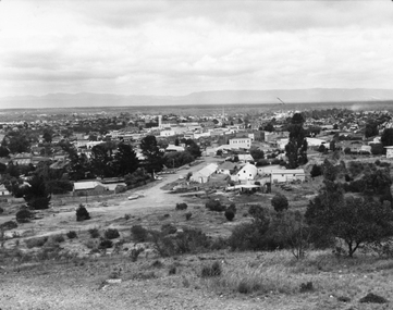
Photograph, Panorama of Stawell from Big Hill c 1960's
... in Background. c 1960 looking Down top end of Sloane Street across... in Background. c 1960 looking Down top end of Sloane Street across ...Panorama View of Stawell from Big Hill with Grampians in Background. c 1960 looking Down top end of Sloane Street across Fisher Street. Stawell Court House visible. Top end of Main Street Visible corner of Patrick and Main StreetBlack & White photo of Stawell from Big Hill. View showing Upper Sloan St with Fisher St crossing to the right. stawell, panorama, streetscape -
 Stawell Historical Society Inc
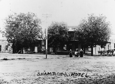
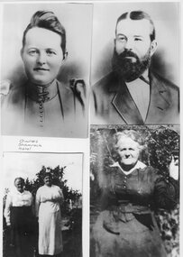
Photograph, Shamrock Hotel on the corner of Seaby & Longfield Streets Stawell West with Mary Jenkins and Agnes Jenkins nee Keegan 1914
... Street and Longfield Streets Pleasant Creek, Stawell West... of Seaby Street and Longfield Streets Pleasant Creek, Stawell West ...Two story weatherboard Shamrock Hotel 1914? corner of Seaby Street and Longfield Streets Pleasant Creek, Stawell West. Standing in Front are Mary Jenkins and Agnes Jenkins nee Keegan second and third from left. Granite Cob & Co Stables on left Buildings behind three large trees, telegraph pole front centre of image. Granite Cob & Co Stables on left Shamrock Hotelstawell business -
 Stawell Historical Society Inc
Photograph, Shamrock Hotel Stawell West Owners -- Clockwise -- top left Mrs Agnes Jenkins nee Keegan, Mr William John Jenkins, Mrs Agnes Jenkins nee Keegan, & Mrs Agnes Jenkins nee Keegan on left
... Street and Longfield Streets Stawell West. Clockwise from top... Street and Longfield Streets Stawell West. Clockwise from top ...Four photos of owners of Shamrock Hotel corner of Seaby Street and Longfield Streets Stawell West. Clockwise from top left Agnes Jenkins nee Keegan. William John Jenkins. Agnes Jenkins nee Keegan. Agnes Jenkins nee Keegan on left Four Photos of people. Woman, man, two ladies and older lady Owners of Shamrock Hotel stawell business -
 Whitehorse Historical Society Inc.
Photograph, Marie Arrowsmith's Home
... lucknow street..., Grandmother of Ted, in Lucknow Street (formerly Scott Street), Mitcham... Mitcham melbourne arrowsmith marie ted scott mrs lucknow street ...Black and white photo of Home of Marie Arrowsmith, Grandmother of Ted, in Lucknow Street (formerly Scott Street), Mitcham. Marie lived there from 1915 to early 1920s. Originally 2 roomed Bungalow, 2 more rooms were added. Virgin bush at rear. House purchased from Mrs Scott of Scott's Estate. House since demolished.arrowsmith, marie, ted, scott, mrs, lucknow street, mitcham -
 Bendigo Historical Society Inc.
Photograph - BENDIGO HOTEL COLLECTION: HIBERNIAN HOTEL, GOLDEN SQUARE
... Square. Hotel situated on corner of High Street and Bay Street... Inc. History House 11 Mackenzie Street Bendigo goldfields ...Colour photograph: Image shows Hibernian Hotel, Golden Square. Hotel situated on corner of High Street and Bay Street. Single storey white painted building, part verandah, some lace work. Corrugated iron roof. Hibernian Hotel written on Bay Street side of building. Single brick chimney, unpainted, Bay Street side.bendigo, hotel, hibernian hotel, golden square -
 Kilmore Historical Society
Photograph, 9 Sydney Street
... 9 Sydney Street... on the corner of Sydney Street and Bourke Street, Kilmore. Light beige...9 Sydney Street, Kilmore, Victoria, Australia...Kilmore Historical Society 4 Powlett Street Kilmore ...Miss Isabelle Taylor live at this residence previously.15cm x 10cm colour photograph of the building which resides on the corner of Sydney Street and Bourke Street, Kilmore. Light beige rendered building, 9 Sydney Street Kilmore, with wooden detail around windows and doors. Neat garden in the front yard and matching colour picket fence. There is some renovation occurring in the photograph. Printed on matte photograph stock. -
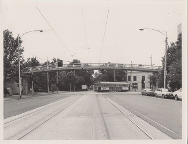 Melbourne Tram Museum
Photograph - Black & White Photograph/s, The Met, mid 1980's
... Swanston Street at Elgin Street, mid 1980's, with sw6 class No. 931... of the new footbridge over Swanston Street at Elgin Street, mid 1980 ...Black and White photograph of the new footbridge over Swanston Street at Elgin Street, mid 1980's, with sw6 class No. 931 in The Met colour scheme turning into Elgin street on route 1, East Coburg. Shows the track at this location, prior to its extensive redevelopment as a terminus. The footbridge, serves Melbourne University. A take-away shop is on the corner.On the rear in ink "Newly erected Road bridge, Swanston St North @ Melb Uni"trams, tramways, swanston st, elgin st, melbourne university, tram 931, sw6 class, the met -
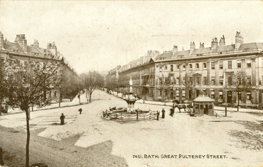 Federation University Historical Collection
Postcard - black and white, Great Pulteney Street, Bath
... Great Pulteney Street, Bath...gret pulteney street...Great Pulteney Street is a grand thoroughfare that connects...A black and white postcard showing Great Pulteney Street... Pulteney Street is a grand thoroughfare that connects Bathwick ...Great Pulteney Street is a grand thoroughfare that connects Bathwick on the east of the River Avon with the City of Bath, England via the Robert Adam designed Pulteney Bridge. Famous former residents of the street have included the novelist Jane Austen and the anti-slavery campaigner William Wilberforce.A black and white postcard showing Great Pulteney Street in Bath. The street is lined with triple storey building. A fountain and small shelter is located in the foreground.This card was purchased by an Australian soldier, probably Henry Smerdon Holmes, during World War One. chatham-holmes family collection, bath, gret pulteney street, fountain -
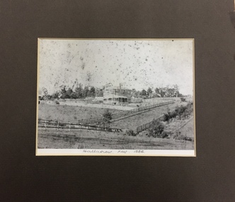 Kew Historical Society Inc
Photograph, 'Hallatrow', Holroyd Street, Kew, 1886, 1886
... 'Hallatrow', Holroyd Street, Kew, 1886...hallatrow - 6 holroyd street - kew )vic)... of Hallatrow, now mounted, originally listed as A'Beckett Street West... holroyd street - kew )vic) historic buidlings - studley park - kew ...An important early photograph of a significant Kew mansion - Hallatrow - dating from 1886, soon after it was constructed.What appears to be a reprint of an earlier photograph of Hallatrow, now mounted, originally listed as A'Beckett Street West or Conran Street, but now 6 Holroyd Street in Studley Park. The photograph was originally taken when the house was occupied by the family of Thomas Brodribb. Pencil: “Hallatrow, Kew, 1886” hallatrow - 6 holroyd street - kew )vic), historic buidlings - studley park - kew (vic) -
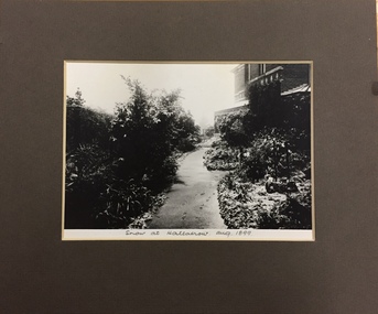 Kew Historical Society Inc
Photograph, Snow at Hallatrow, Aug 1899, 1899
... hallatrow - 6 holroyd street - kew )vic)... of Hallatrow, now mounted, originally listed as A'Beckett Street West... - dating from 1899. hallatrow - 6 holroyd street - kew )vic ...An important early photograph of a significant Kew mansion - Hallatrow - dating from 1899.What appears to be a reprint of an earlier photograph of Hallatrow, now mounted, originally listed as A'Beckett Street West or Conran Street, but now 6 Holroyd Street in Studley Park. The photograph was originally taken when the house was occupied by the family of Thomas Brodribb. Pencil: “Snow at Hallatrow, Aug 1899” hallatrow - 6 holroyd street - kew )vic), historic buidlings - studley park - kew (vic) -
 City of Ballarat Libraries
Photograph - Card Box Photographs, Views looking east and west along Bridge Street, Ballarat c1915
... Views looking east and west along Bridge Street, Ballarat...Bridge Street...East and west views along Bridge Street. Buildings along...City of Ballarat Libraries Eureka Centre Eureka Street ...East and west views along Bridge Street. Buildings along the streets include Cowdell Tonner & Ellis and the Bucks Head Hotel. This comes from the Ballarat Homecoming publication.bridge street, ballarat, streetscape, buildings, cowdell tonner & ellis, bucks head hotel, public, commerical, hotel, ballarat homecoming -
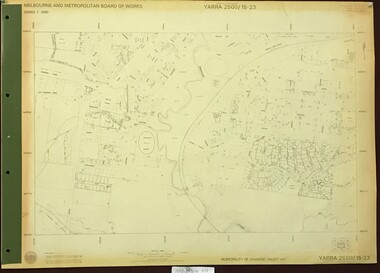 Greensborough Historical Society
Map, Melbourne and Metropolitan Board of Works. Survey Division, MMBW, Yarra 2500 / 15.23. Diamond Creek Reserve, 1978_02
... . Prominent streets include: Challenger Street, James Cook Drive... of Diamond Valley 257. Prominent streets include: Challenger Street ...Melbourne and Metropolitan Board of Works. Yarra 2500 [base map] 15.23. Hurstbridge. Municipality of Diamond Valley 257. Prominent streets include: Challenger Street, James Cook Drive and Ryans Road / Main Street. Features include the Diamond Creek and Diamond Creek Reserve.MMBW Map in 1:2500 [scale] series. Cream parchment with green tape reinforcing on edges and punched holes on left edge.mmbw, melbourne and metropolitan board of works, shire of diamond valley, diamond creek - maps -
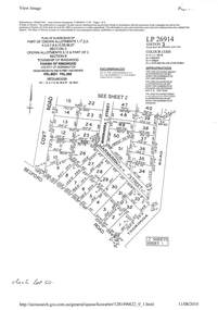 Ringwood and District Historical Society
Document - Subdivision Plan, LP26914 Multiple Crown Allotments, Parish of Ringwood, County of Mornington, Vol 8021 Fol 053 - 1954
... Bedford Park Road then Hill Street), Marwarra Street and Tooronga... Bedford Park Road then Hill Street), Marwarra Street and Tooronga ...LANDATA Land Victoria plan printout dated 2010Part of Crown Allotments 1, 1A, 2, 3, 4, 5, 6, 7, 8, 9, 10, 55, 56, 57. Section C Crown Allotments 3, 12 & part of 2. Section B Map includes Bedford Road, Government Road (later Bedford Park Road then Hill Street), Marwarra Street and Tooronga Road, Ringwood. (Sheet 1 of 2 - Sheet 2 not included with collection). -
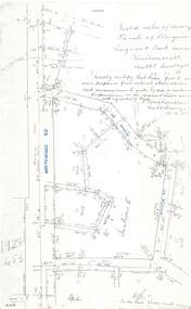 Ringwood and District Historical Society
Document - Copy of Lands Department Field Notes - Parish of Ringwood, Victoria, Field Notes - 1928/453 - Part of OP R72C Surveyed on 17.11.1928
... , Wilson Street, Rupert Street, New Road (Braeside Avenue), Section... Whitehorse Road, Mines Road, Wilson Street, Rupert Street, New Road ...5616b Foolscap size photocopy of survey map with handwritten notations. References include Whitehorse Road, Mines Road, Wilson Street, Rupert Street, New Road (Braeside Avenue), Section E, Allot 31 sold, Allot 32 sold, Recreation Reserve, Allot 25 sold, Allot 29 sold, hedge, spikes, links on line from each corner, I hereby certify that these field notes were prepared from actual observations and measurements made by me or under my supervision on the ground and in accord with regulations (signed) Authorised Surveyor 17/11/28.